Learn how to add features from feature layers to a map.
A feature layer is a dataset in a hosted feature service. Each feature layer contains features with a single geometry type (point, line, or polygon), and a set of attributes. You can access and display features by making query requests to the feature service and displaying them in a map.
In this tutorial, you access and display three different hosted feature layers.
The feature layers are:
Prerequisites
You need an ArcGIS Location Platform or ArcGIS Online account.
Steps
Get the starter app
Select a type of authentication and follow the steps to create a new app.
Choose API key authentication if you:
- Want the easiest way to get started.
- Want to build public applications that access ArcGIS Location Services and secure items.
- Have an ArcGIS Location Platform or ArcGIS Online account.
Choose user authentication if you:
- Want to build private applications.
- Require application users to sign in with their own ArcGIS account and access resources their behalf.
- Have an ArcGIS Online account.
To learn more about both types of authentication, go to Authentication.
Set up authentication
Set developer credentials
Use the API key or OAuth developer credentials so your application can access ArcGIS services.
Add a point feature layer
Point features are typically displayed in a feature layer on top of all other layers. Use the Feature class to reference the Trailheads URL and add features to the map.
-
Go to the Trailheads URL and browse the properties of the layer. Make note of the Name, Type, Drawing Info, and Fields properties.
-
In CodePen, create a
Featureand set theLayer urlproperty.Use dark colors for code blocks L.esri.Vector.vectorBasemapLayer(basemapEnum, { token: accessToken }).addTo(map); var trailheads = L.esri .featureLayer({ url: "https://services3.arcgis.com/GVgbJbqm8hXASVYi/arcgis/rest/services/Trailheads_Styled/FeatureServer/0" }); -
Add the
trailheadslayer to the map.Use dark colors for code blocks L.esri.Vector.vectorBasemapLayer(basemapEnum, { token: accessToken }).addTo(map); var trailheads = L.esri .featureLayer({ url: "https://services3.arcgis.com/GVgbJbqm8hXASVYi/arcgis/rest/services/Trailheads_Styled/FeatureServer/0" }); trailheads.addTo(map); -
Run the app to view the Trailheads layer in the map.
Add a line feature layer
Line features are typically displayed in a feature layer below points. Use the Feature class to reference the Trails URL and add features to the map.
-
Go to the Trails URL and browse the properties of the layer. Make note of the Name, Type, Drawing Info, and Fields properties.
-
In CodePen, create a
Featureand set theLayer urlproperty.Use dark colors for code blocks var trailheads = L.esri .featureLayer({ url: "https://services3.arcgis.com/GVgbJbqm8hXASVYi/arcgis/rest/services/Trailheads_Styled/FeatureServer/0" }); trailheads.addTo(map); var trails = L.esri .featureLayer({ url: "https://services3.arcgis.com/GVgbJbqm8hXASVYi/arcgis/rest/services/Trails_Styled/FeatureServer/0" }); -
Add the
trailslayer to the map.Use dark colors for code blocks var trailheads = L.esri .featureLayer({ url: "https://services3.arcgis.com/GVgbJbqm8hXASVYi/arcgis/rest/services/Trailheads_Styled/FeatureServer/0" }); trailheads.addTo(map); var trails = L.esri .featureLayer({ url: "https://services3.arcgis.com/GVgbJbqm8hXASVYi/arcgis/rest/services/Trails_Styled/FeatureServer/0" }); trails.addTo(map); -
Run the app to view the Trails layer in the map.
Add a polygon feature layer
Polygon features are typically displayed in a feature layer below lines. Use the Feature class to reference the Parks and Open Spaces URL and add features to the map.
-
Go to the Parks and Open Spaces URL and browse the properties of the layer. Make note of the Name, Type, Drawing Info, and Fields properties.
-
In CodePen, create a
Featureand set theLayer urlproperty.Use dark colors for code blocks var trailheads = L.esri .featureLayer({ url: "https://services3.arcgis.com/GVgbJbqm8hXASVYi/arcgis/rest/services/Trailheads_Styled/FeatureServer/0" }); trailheads.addTo(map); var trails = L.esri .featureLayer({ url: "https://services3.arcgis.com/GVgbJbqm8hXASVYi/arcgis/rest/services/Trails_Styled/FeatureServer/0" }); trails.addTo(map); var parks = L.esri .featureLayer({ url: "https://services3.arcgis.com/GVgbJbqm8hXASVYi/arcgis/rest/services/Parks_and_Open_Space_Styled/FeatureServer/0" }); -
Add the
parkslayer to the map.Use dark colors for code blocks var trailheads = L.esri .featureLayer({ url: "https://services3.arcgis.com/GVgbJbqm8hXASVYi/arcgis/rest/services/Trailheads_Styled/FeatureServer/0" }); trailheads.addTo(map); var trails = L.esri .featureLayer({ url: "https://services3.arcgis.com/GVgbJbqm8hXASVYi/arcgis/rest/services/Trails_Styled/FeatureServer/0" }); trails.addTo(map); var parks = L.esri .featureLayer({ url: "https://services3.arcgis.com/GVgbJbqm8hXASVYi/arcgis/rest/services/Parks_and_Open_Space_Styled/FeatureServer/0" }); parks.addTo(map);
Run the app
Run the app.
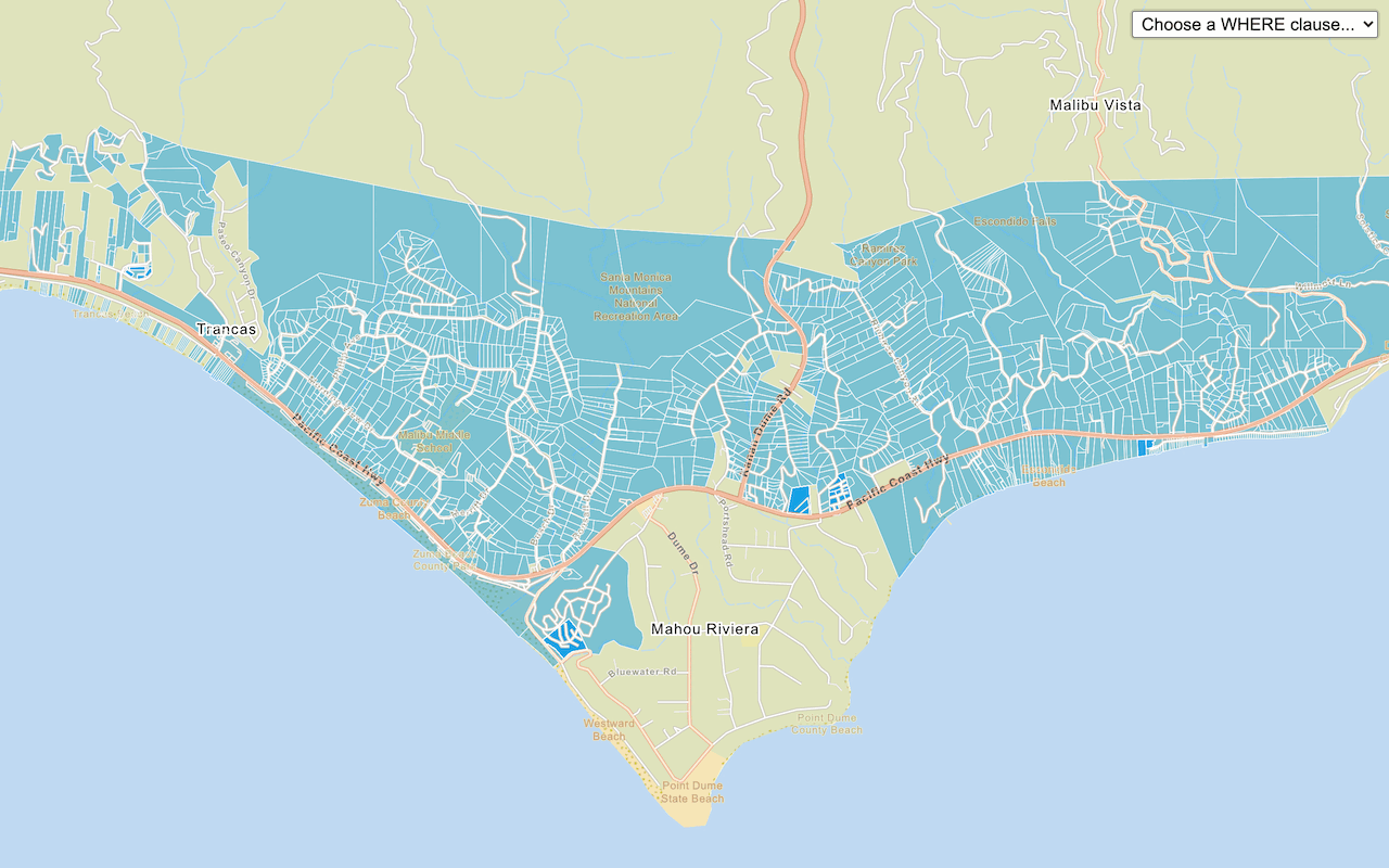
Your map should display the locations of trailheads, trails, and open spaces in the Santa Monica Mountains.The map view should display all three feature layers in the map. The map view draws the map in following order:
- Topographic basemap layer
- Trailheads (points)
- Trails (lines)
- Parks and Open Spaces (polygons)
It is important to add feature layers in the correct order so that features are displayed correctly (not overlapping) and so you can interact with the features.
What's next?
Learn how to use additional location services in these tutorials:
Query a feature layer (SQL)
Execute a SQL query to access polygon features from a feature layer.

Query a feature layer (spatial)
Execute a spatial query to access polygon features from a feature service.

Style a feature layer
Use data-driven styling to apply symbol colors and styles to feature layers.

Display a pop-up
Display feature attributes in a popup.