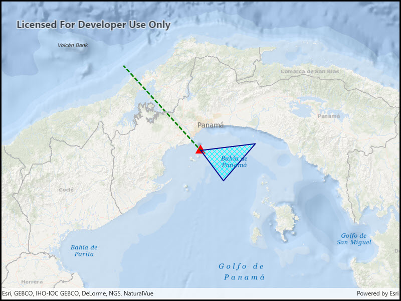
Create a Feature Collection Layer from a Feature Collection Table, and add it to a map.
Use case
A Feature Collection allows easily importing external data (such as CSV files), as well as creating custom schema for data that is in non-standardized format. This data can then be used to populate a Feature Collection Table, and displayed in a Feature Collection Layer using the attributes and geometries provided in the external data source. For example, an electricity supplier could use this functionality to visualize existing location data of coverage areas (polygons), power stations (points), transmission lines (polylines), and others.
How to use the sample
When launched, this sample displays a
with a , and geometry.How it works
- Create a using a new feature collection,
- Add the feature collection layer to the map, .
- Create a for the s , , and ,
- Additionally, pass in a list of objects to represent the table’s schema. In this case a field of type String named is added.
- Assign a to each table to render any s from that table using the that was set.
- Add the feature collection table to the feature collection, .
- Use the method to create a feature from the feature collection table, passing an attribute and geometry for that feature, .
- Add new features to the table, .
Relevant API
- Feature
- FeatureCollection
- FeatureCollectionLayer
- FeatureCollectionTable
- Field
- SimpleRenderer
Tags
feature collection, layers
Sample Code
<UserControl x:Class="ArcGIS.WinUI.Samples.CreateFeatureCollectionLayer.CreateFeatureCollectionLayer" xmlns="http://schemas.microsoft.com/winfx/2006/xaml/presentation" xmlns:x="http://schemas.microsoft.com/winfx/2006/xaml" xmlns:esriUI="using:Esri.ArcGISRuntime.UI.Controls"> <Grid> <esriUI:MapView x:Name="MyMapView" /> </Grid></UserControl>// Copyright 2016 Esri.//// Licensed under the Apache License, Version 2.0 (the "License"); you may not use this file except in compliance with the License.// You may obtain a copy of the License at: http://www.apache.org/licenses/LICENSE-2.0//// Unless required by applicable law or agreed to in writing, software distributed under the License is distributed on an// "AS IS" BASIS, WITHOUT WARRANTIES OR CONDITIONS OF ANY KIND, either express or implied. See the License for the specific// language governing permissions and limitations under the License.
using Esri.ArcGISRuntime.Data;using Esri.ArcGISRuntime.Geometry;using Esri.ArcGISRuntime.Mapping;using Esri.ArcGISRuntime.Symbology;using System;using System.Collections.Generic;using System.Drawing;using System.Threading.Tasks;
namespace ArcGIS.WinUI.Samples.CreateFeatureCollectionLayer{ [ArcGIS.Samples.Shared.Attributes.Sample( name: "Feature collection layer", category: "Layers", description: "Create a Feature Collection Layer from a Feature Collection Table, and add it to a map.", instructions: "When launched, this sample displays a `FeatureCollectionLayer` with a `Point`, `Polyline` and `Polygon` geometry.", tags: new[] { "feature collection", "layers" })] public partial class CreateFeatureCollectionLayer { public CreateFeatureCollectionLayer() { InitializeComponent();
// Call a function to set up the map Initialize(); }
private void Initialize() { // Create a new map with the oceans basemap and add it to the map view Map myMap = new Map(BasemapStyle.ArcGISOceans); MyMapView.Map = myMap;
// Call a function that will create a new feature collection layer and zoom to it _ = CreateNewFeatureCollection(); }
private async Task CreateNewFeatureCollection() { // Create the schema for a points table (one text field to contain a name attribute) List<Field> pointFields = new List<Field>(); Field placeField = new Field(FieldType.Text, "Place", "Place Name", 50); pointFields.Add(placeField);
// Create the schema for a lines table (one text field to contain a name attribute) List<Field> lineFields = new List<Field>(); Field boundaryField = new Field(FieldType.Text, "Boundary", "Boundary Name", 50); lineFields.Add(boundaryField);
// Create the schema for a polygon table (one text field to contain a name attribute) List<Field> polyFields = new List<Field>(); Field areaField = new Field(FieldType.Text, "AreaName", "Area Name", 50); polyFields.Add(areaField);
// Instantiate FeatureCollectionTables with schema and geometry type FeatureCollectionTable pointsTable = new FeatureCollectionTable(pointFields, GeometryType.Point, SpatialReferences.Wgs84); FeatureCollectionTable linesTable = new FeatureCollectionTable(lineFields, GeometryType.Polyline, SpatialReferences.Wgs84); FeatureCollectionTable polysTable = new FeatureCollectionTable(polyFields, GeometryType.Polygon, SpatialReferences.Wgs84);
// Set rendering for each table pointsTable.Renderer = CreateRenderer(GeometryType.Point); linesTable.Renderer = CreateRenderer(GeometryType.Polyline); polysTable.Renderer = CreateRenderer(GeometryType.Polygon);
// Create a new point feature, provide geometry and attribute values Feature pointFeature = pointsTable.CreateFeature(); pointFeature.SetAttributeValue(placeField, "Current location"); MapPoint point1 = new MapPoint(-79.497238, 8.849289, SpatialReferences.Wgs84); pointFeature.Geometry = point1;
// Create a new line feature, provide geometry and attribute values Feature lineFeature = linesTable.CreateFeature(); lineFeature.SetAttributeValue(boundaryField, "AManAPlanACanalPanama"); MapPoint point2 = new MapPoint(-80.035568, 9.432302, SpatialReferences.Wgs84); Polyline line = new Polyline(new MapPoint[] { point1, point2 }); lineFeature.Geometry = line;
// Create a new polygon feature, provide geometry and attribute values Feature polyFeature = polysTable.CreateFeature(); polyFeature.SetAttributeValue(areaField, "Restricted area"); MapPoint point3 = new MapPoint(-79.337936, 8.638903, SpatialReferences.Wgs84); MapPoint point4 = new MapPoint(-79.11409, 8.895422, SpatialReferences.Wgs84); Polygon poly = new Polygon(new MapPoint[] { point1, point3, point4 }); polyFeature.Geometry = poly;
try { // Add the new features to the appropriate feature collection table await pointsTable.AddFeatureAsync(pointFeature); await linesTable.AddFeatureAsync(lineFeature); await polysTable.AddFeatureAsync(polyFeature);
// Create a feature collection and add the feature collection tables FeatureCollection featuresCollection = new FeatureCollection(); featuresCollection.Tables.Add(pointsTable); featuresCollection.Tables.Add(linesTable); featuresCollection.Tables.Add(polysTable);
// Create a FeatureCollectionLayer FeatureCollectionLayer collectionLayer = new FeatureCollectionLayer(featuresCollection);
// When the layer loads, zoom the map centered on the feature collection await collectionLayer.LoadAsync(); await MyMapView.SetViewpointCenterAsync(collectionLayer.FullExtent.GetCenter(), 1000000);
// Add the layer to the Map's Operational Layers collection MyMapView.Map.OperationalLayers.Add(collectionLayer); } catch (Exception e) { await new MessageDialog2(e.ToString(), "Error").ShowAsync(); } }
private Renderer CreateRenderer(GeometryType rendererType) { // Return a simple renderer to match the geometry type provided Symbol sym = null;
switch (rendererType) { case GeometryType.Point: case GeometryType.Multipoint: // Create a marker symbol sym = new SimpleMarkerSymbol(SimpleMarkerSymbolStyle.Triangle, Color.Red, 18); break;
case GeometryType.Polyline: // Create a line symbol sym = new SimpleLineSymbol(SimpleLineSymbolStyle.Dash, Color.Green, 3); break;
case GeometryType.Polygon: // Create a fill symbol SimpleLineSymbol lineSym = new SimpleLineSymbol(SimpleLineSymbolStyle.Solid, Color.DarkBlue, 2); sym = new SimpleFillSymbol(SimpleFillSymbolStyle.DiagonalCross, Color.Cyan, lineSym); break;
default: break; }
// Return a new renderer that uses the symbol created above return new SimpleRenderer(sym); } }}