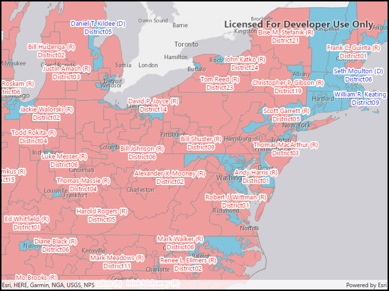
Display custom labels on a feature layer.
Use case
Labeling features is useful to visually display a key piece of information or attribute of a feature on a map. For example, you may want to label rivers or streets with their names.
How to use the sample
Pan and zoom around the United States. Labels for congressional districts will be shown in red for Republican districts and blue for Democrat districts. Notice how labels pop into view as you zoom in.
How it works
- Create a using a feature service URL.
- Create a from the service feature table.
- Create a to use for displaying the label text.
- Create an for the label definition.
- You can use fields of the feature by using in the expression.
- Create a new from the arcade label expression and text symbol.
- Add the definition to the feature layer with .
- Lastly, enable labels on the layer using .
Relevant API
- ArcadeLabelExpression
- FeatureLayer
- LabelDefinition
- TextSymbol
About the data
This sample uses the USA 116th Congressional Districts feature layer hosted on ArcGIS Online.
Additional information
Help regarding the Arcade label expression script for defining a label definition can be found on the ArcGIS Developers site.
Tags
arcade, attribute, deconfliction, label, labeling, string, symbol, text, visualization
Sample Code
<UserControl x:Name="_this" x:Class="ArcGIS.WinUI.Samples.ShowLabelsOnLayer.ShowLabelsOnLayer" xmlns="http://schemas.microsoft.com/winfx/2006/xaml/presentation" xmlns:x="http://schemas.microsoft.com/winfx/2006/xaml" xmlns:esriUI="using:Esri.ArcGISRuntime.UI.Controls"> <Grid> <esriUI:MapView x:Name="MyMapView" /> </Grid></UserControl>// Copyright 2021 Esri.//// Licensed under the Apache License, Version 2.0 (the "License"); you may not use this file except in compliance with the License.// You may obtain a copy of the License at: http://www.apache.org/licenses/LICENSE-2.0//// Unless required by applicable law or agreed to in writing, software distributed under the License is distributed on an// "AS IS" BASIS, WITHOUT WARRANTIES OR CONDITIONS OF ANY KIND, either express or implied. See the License for the specific// language governing permissions and limitations under the License.
using Esri.ArcGISRuntime.Data;using Esri.ArcGISRuntime.Geometry;using Esri.ArcGISRuntime.Mapping;using Esri.ArcGISRuntime.Mapping.Labeling;using Esri.ArcGISRuntime.Symbology;using System;using System.Drawing;using System.Threading.Tasks;
namespace ArcGIS.WinUI.Samples.ShowLabelsOnLayer{ [ArcGIS.Samples.Shared.Attributes.Sample( name: "Show labels on layers", category: "Layers", description: "Display custom labels on a feature layer.", instructions: "Pan and zoom around the United States. Labels for congressional districts will be shown in red for Republican districts and blue for Democrat districts. Notice how labels pop into view as you zoom in.", tags: new[] { "arcade", "attribute", "deconfliction", "label", "labeling", "string", "symbol", "text", "visualization" })] public partial class ShowLabelsOnLayer { public ShowLabelsOnLayer() { InitializeComponent(); _ = Initialize(); }
private async Task Initialize() { // Create a map with a light gray canvas basemap. Map sampleMap = new Map(BasemapStyle.ArcGISLightGray);
// Assign the map to the MapView. MyMapView.Map = sampleMap;
// Define the URL string for the feature layer. string layerUrl = "https://services.arcgis.com/P3ePLMYs2RVChkJx/arcgis/rest/services/USA_116th_Congressional_Districts/FeatureServer/0";
// Create a service feature table from the URL. ServiceFeatureTable featureTable = new ServiceFeatureTable(new Uri(layerUrl));
// Create a feature layer from the service feature table. FeatureLayer districtFeatureLayer = new FeatureLayer(featureTable);
// Add the feature layer to the operations layers collection of the map. sampleMap.OperationalLayers.Add(districtFeatureLayer);
try { // Load the feature layer - this way we can obtain it's extent. await districtFeatureLayer.LoadAsync();
// Zoom the map view to the extent of the feature layer. await MyMapView.SetViewpointCenterAsync(new MapPoint(-10846309.950860, 4683272.219411, SpatialReferences.WebMercator), 20000000);
// create label definitions for each party. LabelDefinition republicanLabelDefinition = MakeLabelDefinition("Republican", Color.Red); LabelDefinition democratLabelDefinition = MakeLabelDefinition("Democrat", Color.Blue);
// Add the label definition to the feature layer's label definition collection. districtFeatureLayer.LabelDefinitions.Add(republicanLabelDefinition); districtFeatureLayer.LabelDefinitions.Add(democratLabelDefinition);
// Enable the visibility of labels to be seen. districtFeatureLayer.LabelsEnabled = true; } catch (Exception ex) { await new MessageDialog2(ex.Message, "Error").ShowAsync(); } }
private LabelDefinition MakeLabelDefinition(string partyName, Color color) { // Create a text symbol for styling the label. TextSymbol textSymbol = new TextSymbol { Size = 12, Color = color, HaloColor = Color.White, HaloWidth = 2, };
// Create a label expression using an Arcade expression script. LabelExpression arcadeLabelExpression = new ArcadeLabelExpression("$feature.NAME + \" (\" + left($feature.PARTY,1) + \")\\nDistrict \" + $feature.CDFIPS");
return new LabelDefinition(arcadeLabelExpression, textSymbol) { Placement = Esri.ArcGISRuntime.ArcGISServices.LabelingPlacement.PolygonAlwaysHorizontal, WhereClause = $"PARTY = '{partyName}'", }; } }}