Search for an address

Learn how to find an address or place using a search box and the geocoding service.

A mapping application that performs geocoding to find the location of street addresses

Find the location of addresses with the geocoding service.

Geocoding is the process of converting address or place text into a location. The geocoding service provides address and place geocoding as well as reverse geocoding.

Esri Leaflet provides a geocoder to access the geocoding service. In this tutorial, you use the Geosearch control to search for addresses and places.

Prerequisites

You need an ArcGIS Developer or ArcGIS Online account to access the developer dashboard and create an API key.

Steps

Create a new pen

  1. To get started, either complete the Display a map tutorial or .

Set the API key

To access location services, you need an API key or OAuth 2.0 access token. To learn how to create and scope your key, visit the Create an API key tutorial.

  1. Go to your dashboard to get an API key. The API key must be scoped to access the services used in this tutorial.

  2. In CodePen, update apiKey to use your key.

    Use dark colors for code blocks
    1
    2
    3
    4
    5
    6
    7
    8
    9
    10
    11
    12
    13
    14
    15
    16
    17
    18
    19
    20
    21
    22
    23
    24
    25
    26
    27
    28
    29
    30
    31
    32
    33
    34
    35
    36
    37
    38
    39
    40
    41
    42
    43
    44
    45
    46
    47
    48
    49
    50
    51
    52
    53
    54
    55
    56
    57
    58
          const map = L.map("map", {
            minZoom: 2
          })
    
          map.setView([34.02, -118.805], 13);
    
          const apiKey = "YOUR_API_KEY";
    
          const basemapEnum = "arcgis/streets";
    
          L.esri.Vector.vectorBasemapLayer(basemapEnum, {
            apiKey: apiKey
          }).addTo(map);
    

Reference the geocoder

  1. Reference the Esri Leaflet Geocoder plugin and its CSS stylesheet.

    Expand
    Use dark colors for code blocks
    1
    2
    3
    4
    5
    6
    7
    8
    9
    10
    11
    12
    13
    14
    15
    16
    17
    18
    19
    20
    21
    22
    23
    24
    25
    26
    27
    28
    29
    30
    31
    32
    33
    34
    35
    36
    37
    38
    39
    40
    41
    42
    43
    44
    45
    46
    47
    48
    49
    50
    51
    52
    53
    54
    55
    56
    57
    58
    59
    60
    61
    62
    63
    64
    65
    66
    67
    68
    69
    70
    71
    72
    73
    74
    75
    76
    77
    78
    79
    80
    81
    82
    83
    84
    85
    86
    87
    88
    89
    90
    91
    92
    93
    94
    95
    96
        <!-- Load Leaflet from CDN -->
        <link rel="stylesheet" href="https://unpkg.com/leaflet@1.9.4/dist/leaflet.css" crossorigin="" />
        <script src="https://unpkg.com/leaflet@1.9.4/dist/leaflet.js" crossorigin=""></script>
    
        <!-- Load Esri Leaflet from CDN -->
        <script src="https://unpkg.com/esri-leaflet@3.0.12/dist/esri-leaflet.js"></script>
        <script src="https://unpkg.com/esri-leaflet-vector@4.2.3/dist/esri-leaflet-vector.js"></script>
    
        <!-- Load Esri Leaflet Geocoder from CDN -->
        <link rel="stylesheet" href="https://unpkg.com/esri-leaflet-geocoder@3.1.4/dist/esri-leaflet-geocoder.css">
        <script src="https://unpkg.com/esri-leaflet-geocoder@3.1.4/dist/esri-leaflet-geocoder.js"></script>
    
    Expand

Update the map

A navigation basemap layer is typically used in geocoding and routing applications. Update the basemap layer to use arcgis/navigation.

  1. Update the basemap style and change the map view to center on location [151.2093, -33.8688], Sydney.

    Expand
    Use dark colors for code blocks
    1
    2
    3
    4
    5
    6
    7
    8
    9
    10
    11
    12
    13
    14
    15
    16
    17
    18
    19
    20
    21
    22
    23
    24
    25
    26
    27
    28
    29
    30
    31
    32
    33
    34
    35
    36
    37
    38
    39
    40
    41
    42
    43
    44
    45
    46
    47
    48
    49
    50
    51
    52
    53
    54
    55
    56
    57
    58
    59
    60
    61
    62
    63
    64
    65
    66
    67
    68
    69
    70
    71
    72
    73
    74
    75
    76
    77
    78
    79
    80
    81
    82
    83
    84
    85
    86
    87
    88
    89
    90
    91
    92
    93
    94
    95
    96
          const apiKey = "YOUR_API_KEY";
    
          const basemapEnum = "arcgis/navigation";
    
          const map = L.map("map", {
            minZoom: 2
          })
    
          map.setView([-33.8688, 151.2093], 14); // Sydney
    
          L.esri.Vector.vectorBasemapLayer(basemapEnum, {
            apiKey: apiKey
          }).addTo(map);
    
    Expand

Add the Geosearch control

Use the Geosearch control to access the geocoding service.

  1. Add the control to the topright corner of the map. Create placeholder text and set useMapBounds to false.

    Expand
    Use dark colors for code blocks
    1
    2
    3
    4
    5
    6
    7
    8
    9
    10
    11
    12
    13
    14
    15
    16
    17
    18
    19
    20
    21
    22
    23
    24
    25
    26
    27
    28
    29
    30
    31
    32
    33
    34
    35
    36
    37
    38
    39
    40
    41
    42
    43
    44
    45
    46
    47
    48
    49
    50
    51
    52
    53
    54
    55
    56
    57
    58
    59
    60
    61
    62
    63
    64
    65
    66
    67
    68
    69
    70
    71
    72
    73
    74
    75
    76
    77
    78
    79
    80
    81
    82
    83
    84
    85
    86
    87
    88
    89
    90
    91
    92
    93
    94
    95
    96
          L.esri.Vector.vectorBasemapLayer(basemapEnum, {
            apiKey: apiKey
          }).addTo(map);
    
          const searchControl = L.esri.Geocoding.geosearch({
            position: "topright",
            placeholder: "Enter an address or place e.g. 1 York St",
            useMapBounds: false,
    
          }).addTo(map);
    
    Expand
  2. Set the providers to arcgisOnlineProvider in order to access the geocoding service. Set your apiKey and the lat and lng so that the geocoder returns the geocoded results for Sydney first.

    Expand
    Use dark colors for code blocks
    1
    2
    3
    4
    5
    6
    7
    8
    9
    10
    11
    12
    13
    14
    15
    16
    17
    18
    19
    20
    21
    22
    23
    24
    25
    26
    27
    28
    29
    30
    31
    32
    33
    34
    35
    36
    37
    38
    39
    40
    41
    42
    43
    44
    45
    46
    47
    48
    49
    50
    51
    52
    53
    54
    55
    56
    57
    58
    59
    60
    61
    62
    63
    64
    65
    66
    67
    68
    69
    70
    71
    72
    73
    74
    75
    76
    77
    78
    79
    80
    81
    82
    83
    84
    85
    86
    87
    88
    89
    90
    91
    92
    93
    94
    95
    96
          const searchControl = L.esri.Geocoding.geosearch({
            position: "topright",
            placeholder: "Enter an address or place e.g. 1 York St",
            useMapBounds: false,
    
            providers: [
              L.esri.Geocoding.arcgisOnlineProvider({
                apikey: apiKey,
                nearby: {
                  lat: -33.8688,
                  lng: 151.2093
                }
              })
            ]
    
          }).addTo(map);
    
    Expand
  3. Run your app, and interact with the auto-complete enabled search control.

Display results

You can display the results of the search using a Marker and Popup.

  1. Add a LayerGroup to the map to contain the geocoding results.

    Expand
    Use dark colors for code blocks
    1
    2
    3
    4
    5
    6
    7
    8
    9
    10
    11
    12
    13
    14
    15
    16
    17
    18
    19
    20
    21
    22
    23
    24
    25
    26
    27
    28
    29
    30
    31
    32
    33
    34
    35
    36
    37
    38
    39
    40
    41
    42
    43
    44
    45
    46
    47
    48
    49
    50
    51
    52
    53
    54
    55
    56
    57
    58
    59
    60
    61
    62
    63
    64
    65
    66
    67
    68
    69
    70
    71
    72
    73
    74
    75
    76
    77
    78
    79
    80
    81
    82
    83
    84
    85
    86
    87
    88
    89
    90
    91
    92
    93
    94
    95
    96
          const searchControl = L.esri.Geocoding.geosearch({
            position: "topright",
            placeholder: "Enter an address or place e.g. 1 York St",
            useMapBounds: false,
    
            providers: [
              L.esri.Geocoding.arcgisOnlineProvider({
                apikey: apiKey,
                nearby: {
                  lat: -33.8688,
                  lng: 151.2093
                }
              })
            ]
    
          }).addTo(map);
    
          const results = L.layerGroup().addTo(map);
    
    
    Expand
  2. Create an event handler to access the data from the search results. Call the clearLayers method to remove the previous data from the LayerGroup.

    Expand
    Use dark colors for code blocks
    1
    2
    3
    4
    5
    6
    7
    8
    9
    10
    11
    12
    13
    14
    15
    16
    17
    18
    19
    20
    21
    22
    23
    24
    25
    26
    27
    28
    29
    30
    31
    32
    33
    34
    35
    36
    37
    38
    39
    40
    41
    42
    43
    44
    45
    46
    47
    48
    49
    50
    51
    52
    53
    54
    55
    56
    57
    58
    59
    60
    61
    62
    63
    64
    65
    66
    67
    68
    69
    70
    71
    72
    73
    74
    75
    76
    77
    78
    79
    80
    81
    82
    83
    84
    85
    86
    87
    88
    89
    90
    91
    92
    93
    94
    95
    96
          const results = L.layerGroup().addTo(map);
    
          searchControl.on("results", (data) => {
            results.clearLayers();
    
          });
    
    Expand
  3. Create a loop that adds the coordinates of a selected search results to a Marker.

    Expand
    Use dark colors for code blocks
    1
    2
    3
    4
    5
    6
    7
    8
    9
    10
    11
    12
    13
    14
    15
    16
    17
    18
    19
    20
    21
    22
    23
    24
    25
    26
    27
    28
    29
    30
    31
    32
    33
    34
    35
    36
    37
    38
    39
    40
    41
    42
    43
    44
    45
    46
    47
    48
    49
    50
    51
    52
    53
    54
    55
    56
    57
    58
    59
    60
    61
    62
    63
    64
    65
    66
    67
    68
    69
    70
    71
    72
    73
    74
    75
    76
    77
    78
    79
    80
    81
    82
    83
    84
    85
    86
    87
    88
    89
    90
    91
    92
    93
    94
    95
    96
          const results = L.layerGroup().addTo(map);
    
          searchControl.on("results", (data) => {
            results.clearLayers();
    
            for (let i = data.results.length - 1; i >= 0; i--) {
              const marker = L.marker(data.results[i].latlng);
    
              results.addLayer(marker);
    
            }
    
          });
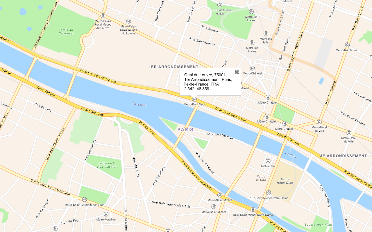
    
    Expand
  4. Add a lngLatString variable that stores the rounded search result coordinates. Append the bindPopup method to the marker to display the coordinates and address of the result.

    Expand
    Use dark colors for code blocks
    1
    2
    3
    4
    5
    6
    7
    8
    9
    10
    11
    12
    13
    14
    15
    16
    17
    18
    19
    20
    21
    22
    23
    24
    25
    26
    27
    28
    29
    30
    31
    32
    33
    34
    35
    36
    37
    38
    39
    40
    41
    42
    43
    44
    45
    46
    47
    48
    49
    50
    51
    52
    53
    54
    55
    56
    57
    58
    59
    60
    61
    62
    63
    64
    65
    66
    67
    68
    69
    70
    71
    72
    73
    74
    75
    76
    77
    78
    79
    80
    81
    82
    83
    84
    85
    86
    87
    88
    89
    90
    91
    92
    93
    94
    95
    96
          const results = L.layerGroup().addTo(map);
    
          searchControl.on("results", (data) => {
            results.clearLayers();
    
            for (let i = data.results.length - 1; i >= 0; i--) {
              const marker = L.marker(data.results[i].latlng);
    
              const lngLatString = `${Math.round(data.results[i].latlng.lng * 100000) / 100000}, ${
                Math.round(data.results[i].latlng.lat * 100000) / 100000
              }`;
              marker.bindPopup(`<b>${lngLatString}</b><p>${data.results[i].properties.LongLabel}</p>`);
    
              results.addLayer(marker);
    
              marker.openPopup();
    
            }
    
          });
    
    Expand

Run the app

In CodePen, run your code to display the map.

Click on the geocoder control and enter an address or place such as "Starbucks". When you select a result, the map will zoom to its location.

What's next?

Learn how to use additional ArcGIS location services in these tutorials:

Your browser is no longer supported. Please upgrade your browser for the best experience. See our browser deprecation post for more details.