GeoAnalytics Engine offers various tools and functions that enable you to analyze and understand the spatial relationships between geometries. For example, to find the number of homes that were affected by a recent flood, you could join the homes to the flood boundary using the Within spatial relationship.
Using functions to analyze spatial relationships
Functions analyze spatial relationships using geometry columns from a DataFrame. Depending on the function, the input can be one or two geometry columns, and in some cases additional spatial considerations (for example, a distance or boundary).
Functions return values of True or False for each geometry depending on whether or not it meets the
spatial conditions specified.
Using tools to analyze spatial relationships
Tools analyze spatial relationships using DataFrames as input. Each input DataFrame must have only one geometry column set in order to be used in an analysis tool.
Tools return DataFrames that contain geometries and columns that can be used to understand the spatial relationship. The contents of the output DataFrame depend on the tool that was used. Some results contain all input geometries with new columns indicating the relationship, and other results contain only the geometries that met the specified condition. See the respective tool help for more information.
This topic outlines spatial relationships available in the tools Spatiotemporal Join and Group By Proximity.
Spatial relationships between geometries
The following legend applies to all the examples in this topic:
-
Geometry 1—Blue
-
Geometry 2—Yellow
-
Geometry 1 exhibits the selected spatial relationship with geometry 2—Red highlight
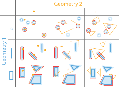
In a spatial relationship, each type of geometry (point, polyline, and polygon) has an interior and a boundary. How the interiors and boundaries of two geometries compare determines the spatial relationship they exhibit. The following image outlines the geometries, boundaries, and interiors of points, polylines, and polygons:

Geometry types and supported relationships
The following table lists the supported spatial relationships between geometries of a given type (for example, the relationship of points to other points):
| Equals | Intersects | Contains | Within | Crosses | Touches | Overlaps | Planar Near | Geodetic Near | Disjoint | EnvIntersects | Relates | DWithin | |
|---|---|---|---|---|---|---|---|---|---|---|---|---|---|
| Point and point | |||||||||||||
| Point and linestring | |||||||||||||
| Point and polygon | |||||||||||||
| Linestring and point | |||||||||||||
| Linestring and linestring | |||||||||||||
| Linestring and polygon | |||||||||||||
| Polygon and point | |||||||||||||
| Polygon and linestring | |||||||||||||
| Polygon and polygon |
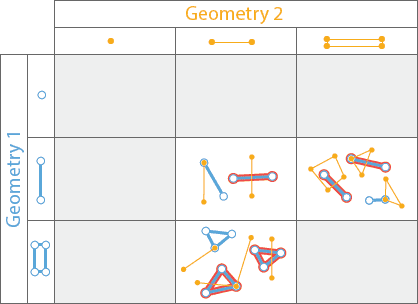
Equals
Geometry 1 is equal to Geometry 2 if their interiors are identical and the geometry types are the same.
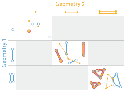
You can access this spatial relationship in the following ways:
- Use the Spatiotemporal Join tool with a value of
Equalsfor thespatialparameter. Geometries in red will be joined._relationship - Use the spatial function ST_Equals. Geometries in red will return a value of
True.
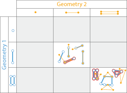
Intersects
Geometry 1 intersects Geometry 2 if it shares any portion of its Geometry with Geometry 2. If Geometry 1 contains, is within, crosses, touches, or overlaps Geometry 2, it intersects.
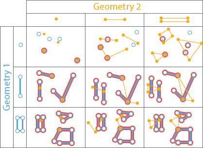
You can access this spatial relationship in the following ways:
- Use the Spatiotemporal Join tool with a value of
Intersectsfor thespatialparameter. Geometries in red will be joined._relationship - Use the Group By Proximity tool with a value of
Intersectsfor thespatialparameter. Geometries in red will be grouped with the intersecting geometries._relationship - Use the spatial function ST_Intersects. Geometries in red will return a value of
True.
Contains
Geometry 1 contains Geometry 2 if Geometry 2 is a subset of Geometry 1, with intersecting interiors. If Geometry 2 is on the boundary and intersects the interior, then Geometry 1 contains Geometry 2. If Geometry 2 is only on the boundary (and not the interior), then Geometry 1 does not contain Geometry 2. This is the inverse of the Within function operator.
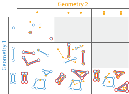
You can access this spatial relationship in the following ways:
- Use the Spatiotemporal Join tool with a value of
Containsfor thespatialparameter. Geometries in red will be joined._relationship - Use the spatial function ST_Contains. Geometries in red will return a value of
True.
Within
Geometry 1 is within Geometry 2 if it is completely inside Geometry 2. A geometry is within if the intersection of the interiors is nonempty and Geometry 1 is a subset of Geometry 2. If there is no intersecting interior, then Geometry 1 is not within Geometry 2. This is the inverse of the Contains operator.
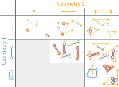
You can access this spatial relationship in the following ways:
- Use the Spatiotemporal Join tool with a value of
Withinfor thespatialparameter. Geometries in red will be joined._relationship - Use the spatial function ST_Within. Geometries in red will return a value of
True.
Crosses
Two linestrings cross if their intersection contains only points, and at least one of the points of intersection is internal to both linestrings. A linestring and polygon cross if a connected part of the linestring is partly inside and partly outside the polygon. A linestring and polygon cross if they share a linestring in common on the interior of the polygon, which is not equal to the entire linestring. Geometry 1 and Geometry 2 must be either linestrings or polygons.
You can access this spatial relationship in the following ways:
- Use the Spatiotemporal Join tool with a value of
Crossesfor thespatialparameter. Geometries in red will be joined._relationship - Use the spatial function ST_Crosses. Geometries in red will return a value of
True.
Touches
Geometry 1 touches Geometry 2 if they have an intersecting vertex, but the geometries do not overlap.

You can access this spatial relationship in the following ways:
- Use the Spatiotemporal Join tool with a value of
Touchesfor thespatialparameter. Geometries in red will be joined._relationship - Use the Group By Proximity tool with a value of
Touchesfor thespatialparameter. Geometries in red will be grouped with the touching geometries._relationship - Use the spatial function ST_Touches. Geometries in red will return a value of
True.
Overlaps
Two geometries overlap if they are the same geometry type and their intersection also has the same geometry type, but the geometry that intersects is different from both of the original geometries.
You can access this spatial relationship in the following ways:
- Use the Spatiotemporal Join tool with a value of
Overlapsfor thespatialparameter. Geometries in red will be joined._relationship - Use the spatial function ST_Overlaps. Geometries in red will return a value of
True.
Near
Conceptually, these operators buffer Geometry 1 using the specified distance and return all the geometries from Geometry 1 that intersect geometries in Geometry 2 with the buffer applied. Planar Near uses Planar distance, and Geodetic Near uses Geodetic distance. Choose the geodetic relationship if your data covers a large geographic extent or the coordinate system of the inputs is geographic.
The Planar Near and Geodetic Near functions work similar to the DWithin function.
You can access this spatial relationship in the following ways:
- Use the Spatiotemporal Join tool with a value of
NearorPlanar Nearfor theGeodetic spatialparameter. Geometries in red will be joined._relationship - Use the Group By Proximity tool with a value of
NearorPlanar Nearfor theGeodetic spatialparameter. Geometries in red will be grouped with the near geometries._relationship - Use the spatial function ST_DWithin.
Disjoint
Disjoint takes two geometry columns as input and determines whether they are intersecting or not. If Geometry 1 does not intersect
Geometry 2 they are disjoint and a value of True is returned; otherwise a value of False is returned.

You can access this spatial relationship using the spatial function ST_Disjoint.
EnvIntersects
EnvIntersects takes a geometry column and envelope values (xmin, ymin, xmax, ymax) as input. If the geometry intersects
with the envelope a value of True will be returned; otherwise a value of False is returned.

You can access this spatial relationship using the spatial function ST_BboxIntersects.
Relate
Relate takes two geometry columns as input and considers a DE-9IM pattern matrix to determine the relationships between each pair of geometries.
If the relationship between Geometry 1 and Geometry 2 meets the conditions specified by the DE-9IM matrix a value of True will be returned;
otherwise a value of False is returned.
You can access this spatial relationship using the function ST_Relate.
DWithin
See Near to learn about DWithin.
You can access this spatial relationship using the function ST_DWithin.
What's next?
Learn more about spatial relationships and spatial functions:
- Use the analysis tool Spatiotemporal Join to analyze relationships between your data
- Use the analysis tool Group By Proximity to analyze relationships of spatial grouping in your data
- Use SQL functions to analyze spatial relationships between geometries
- Learn about temporal relationships in the Spatiotemporal Join tool
- Enable geometry on a DataFrame