import Legend from "@arcgis/core/widgets/Legend.js";const Legend = await $arcgis.import("@arcgis/core/widgets/Legend.js");- Since
- ArcGIS Maps SDK for JavaScript 4.0
The Legend widget describes the symbols used to represent layers in a map.
All symbols and text used in this widget are configured in the
Renderer of the layer.
The legend will only display layers and sublayers that are
visible in the view unless respectLayerVisibility is false.
The legend automatically updates when
- the visibility of a layer or sublayer changes
- a layer is added or removed from the map
- a layer's
renderer,opacity, ortitleis changed - the
legendEnabledproperty is changed (set totrueorfalseon the layer)
You can use the view's DefaultUI to add widgets
to the view's user interface via the ui property on the view.
Known Limitations
Currently, the legend widget does not support the following layer types: ElevationLayer, GraphicsLayer, IntegratedMeshLayer, KMLLayer, MapNotesLayer, OpenStreetMapLayer, VectorTileLayer, VideoLayer, and WebTileLayer. 3D symbols with more than one symbol layer are not supported. DictionaryRenderer is not supported.
Expand the "Read more" section below to view various examples of legends based on renderer type.
Read More
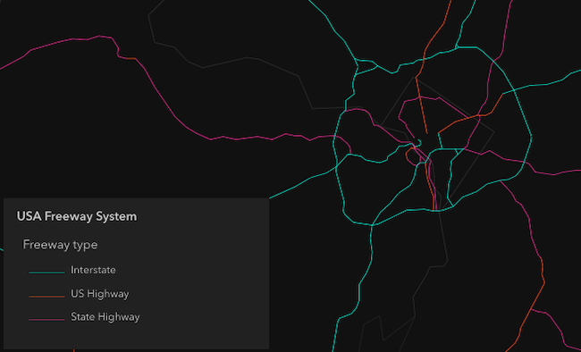
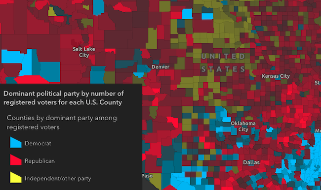
Unique values
Continuous color

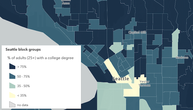
Classed color
Continuous size

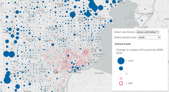
Size - above and below
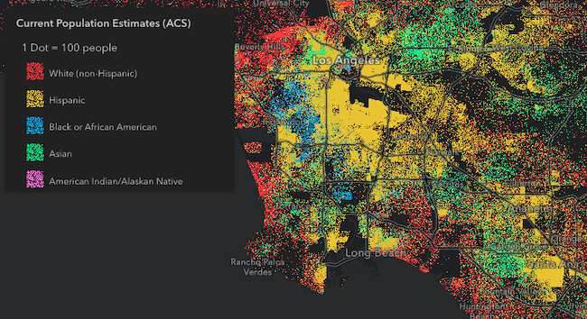
Dot density
Predominance
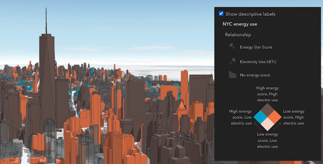
Relationship
- See also
Example
let legend = new Legend({  view: view});
view.ui.add(legend, "bottom-right");
Constructors
Constructor
Parameters
| Parameter | Type | Description | Required |
|---|---|---|---|
| properties | | |
Example
// typical usagelet legend = new Legend({ view: view});Properties
| Property | Type | Class |
|---|---|---|
| | ||
| | ||
container inherited | HTMLElement | null | undefined | |
declaredClass readonly inherited | ||
destroyed readonly inherited | ||
| | ||
| | ||
Icon["icon"] | | |
id inherited | ||
| | ||
| | ||
| | ||
| | ||
| | ||
| | ||
| | ||
visible inherited |
activeLayerInfos
- Type
- Collection<ActiveLayerInfo>
Collection of ActiveLayerInfo objects used by the legend view to display data in the legend. The legend widget watches this property to hide or display the layer's legend when an ActiveLayerInfo is removed from or added to this collection.
basemapLegendVisible
- Type
- boolean
Indicates whether to show the Basemap layers in the Legend. If you set this property to
true and specify layerInfos, the basemap layers you want included in the legend must also be
specified in layerInfos.
- Default value
- false
Example
legend.basemapLegendVisible = true; container
- Type
- HTMLElement | null | undefined
The ID or node representing the DOM element containing the widget. This property can only be set once. The following examples are all valid use case when working with widgets.
Examples
// Create the HTML div element programmatically at runtime and set to the widget's containerconst basemapGallery = new BasemapGallery({  view: view,  container: document.createElement("div")});
// Add the widget to the top-right corner of the viewview.ui.add(basemapGallery, {  position: "top-right"});
// Specify an already-defined HTML div element in the widget's container
const basemapGallery = new BasemapGallery({ view: view, container: basemapGalleryDiv});
// Add the widget to the top-right corner of the viewview.ui.add(basemapGallery, { position: "top-right"});
// HTML markup<body> <div id="viewDiv"></div> <div id="basemapGalleryDiv"></div></body>// Specify the widget while adding to the view's UIconst basemapGallery = new BasemapGallery({ view: view});
// Add the widget to the top-right corner of the viewview.ui.add(basemapGallery, { position: "top-right"}); headingLevel
- Type
- HeadingLevel
- Since
- ArcGIS Maps SDK for JavaScript 4.20
Indicates the heading level to use for the legend title. By default, legend titles
are rendered as level 3 headings (e.g. <h3>Legend title</h3>). Depending on the legend placement
in your app, you may need to adjust this heading for proper semantics. This is
important for meeting accessibility standards.
- See also
- Default value
- 3
Example
// legend title will render as an <h2>legend.headingLevel = 2; hideLayersNotInCurrentView
- Type
- boolean
- Since
- ArcGIS Maps SDK for JavaScript 4.21
When true, layers will only be shown in the legend if
they are visible in the view's extent. When data from a layer
is not visible in the view, the layer's legend information
will be hidden. Only layers that implement the createQuery()
and queryFeatureCount() methods are supported by hideLayersNotInCurrentView.
To hide layers completely
from the legend, you should set the legendEnabled property of
the layer to false.
- See also
- Default value
- false
Example
// layers not displayed in the view// will not be shown in the legendlegend.hideLayersNotInCurrentView = true; icon
- Type
- Icon["icon"]
- Since
- ArcGIS Maps SDK for JavaScript 4.27
Icon which represents the widget. It is typically used when the widget is controlled by another one (e.g. in the Expand widget).
- Default value
- "legend"
layerInfos
- Type
- LayerInfo[]
Defines which layers and sublayers are shown in the legend, including any basemap layers you want visible.
If not set, all layers in the map are displayed in the legend by default, including basemap layers when
basemapLegendVisible is true.
Example
const subtypeGroupLayer = webmap.layers.getItemAt(0);const subtypeSubLayer = subtypeGroupLayer.sublayers.getItemAt(1);const subtypeSublayerId = parseInt(subtypeSubLayer.subtypeCode);const legend = new Legend({ view: view, layerInfos: [ { layer: subtypeGroupLayer, sublayerIds: [subtypeSublayerId] } ]}); respectLayerDefinitionExpression
- Type
- boolean
- Since
- ArcGIS Maps SDK for JavaScript 4.30
If a layer uses a unique value render, only features that satisfy the layer's definition expression will be displayed in the legend when set to true.
- Default value
- false
respectLayerVisibility
- Type
- boolean
- Since
- ArcGIS Maps SDK for JavaScript 4.13
Determines whether to respect the properties of the layers in the map that
control the legend's visibility (minScale, maxScale, legendEnabled).
By default, a layer's legend elements will
not render in the legend given the following conditions:
- The layer's FeatureLayer.legendEnabled property
is set to
false. - If the view's scale is outside the visibility range defined by the layer's ScaleRangeLayer.minScale and ScaleRangeLayer.maxScale properties.
When the respectLayerVisibility property of the legend is set to false, the legend elements for each
layer in the map will always display, thus disregarding the minScale, maxScale,
and legendEnabled properties for each layer in the map.
- See also
- Default value
- true
Example
// Always displays legend elements for the map's layers// regardless of their minScale, maxScale, and legendEnabled propertieslegend.respectLayerVisibility = false; style
- Type
- LegendStyle
- Since
- ArcGIS Maps SDK for JavaScript 4.7
Indicates the style of the legend. The style determines the legend's layout and behavior.
You can either specify a string or an object to indicate the style. The known string values are the same values listed in
the table within the type property.
- Default value
- "classic"
Examples
// renders the legend in the card style with a "stack" layoutlegend.style = "card";// renders the legend in the card style with a responsive// layout that toggles between "stack" and "side-by-side"legend.style = { type: "card", layout: "auto"};// renders the legend in the classic layoutlegend.style = "classic"; view
- Type
- MapViewOrSceneView | LinkChartView | null | undefined
A reference to the MapView, LinkChartView, or SceneView. Set this to link the widget to a specific view.
viewModel
- Type
- LegendViewModel
The view model for this widget. This is a class that contains all the logic (properties and methods) that controls this widget's behavior. See the LegendViewModel class to access all properties and methods on the widget.
visible
- Type
- boolean
Indicates whether the widget is visible.
If false, the widget will no longer be rendered in the web document. This may affect the layout of other elements or widgets in the document. For example, if this widget is
the first of three widgets associated to the upper right hand corner of the DefaultUI, then the other widgets will reposition when this widget is made invisible.
For more information, refer to the css display value of "none".
- Default value
- true
Example
// Hides the widget in the viewwidget.visible = false;Methods
| Method | Signature | Class |
|---|---|---|
classes inherited | classes(...classNames: ((string | null | undefined) | ((string[] | Record<string, boolean>) | null | undefined) | false | null | undefined)[]): string | |
destroy inherited | destroy(): void | |
emit inherited | emit<Type extends EventNames<this>>(type: Type, event?: this["@eventTypes"][Type]): boolean | |
hasEventListener inherited | hasEventListener<Type extends EventNames<this>>(type: Type): boolean | |
isFulfilled inherited | isFulfilled(): boolean | |
isRejected inherited | isRejected(): boolean | |
isResolved inherited | isResolved(): boolean | |
on inherited | on<Type extends EventNames<this>>(type: Type, listener: EventedCallback<this["@eventTypes"][Type]>): ResourceHandle | |
postInitialize inherited | postInitialize(): void | |
render inherited | render(): any | null | |
renderNow inherited | renderNow(): void | |
scheduleRender inherited | scheduleRender(): void | |
when inherited | when<TResult1 = this, TResult2 = never>(onFulfilled?: OnFulfilledCallback<this, TResult1> | null | undefined, onRejected?: OnRejectedCallback<TResult2> | null | undefined): Promise<TResult1 | TResult2> |
classes
- Signature
-
classes (...classNames: ((string | null | undefined) | ((string[] | Record<string, boolean>) | null | undefined) | false | null | undefined)[]): string
- Since
- ArcGIS Maps SDK for JavaScript 4.7
A utility method used for building the value for a widget's class property.
This aids in simplifying css class setup.
Parameters
- Returns
- string
The computed class name.
Example
// .tsx syntax showing how to set css classes while rendering the widget
render() {  const dynamicClasses = {    [css.flip]: this.flip,    [css.primary]: this.primary  };
return ( <div class={classes(css.root, css.mixin, dynamicClasses)} /> );} emit
- Signature
-
emit <Type extends EventNames<this>>(type: Type, event?: this["@eventTypes"][Type]): boolean
- Type parameters
- <Type extends EventNames<this>>
- Since
- ArcGIS Maps SDK for JavaScript 4.5
Emits an event on the instance. This method should only be used when creating subclasses of this class.
hasEventListener
- Signature
-
hasEventListener <Type extends EventNames<this>>(type: Type): boolean
- Type parameters
- <Type extends EventNames<this>>
Indicates whether there is an event listener on the instance that matches the provided event name.
Parameters
| Parameter | Type | Description | Required |
|---|---|---|---|
| type | Type | The name of the event. | |
- Returns
- boolean
Returns true if the class supports the input event.
isFulfilled
- Signature
-
isFulfilled (): boolean
isFulfilled() may be used to verify if creating an instance of the class is fulfilled (either resolved or rejected).
If it is fulfilled, true will be returned.
- Returns
- boolean
Indicates whether creating an instance of the class has been fulfilled (either resolved or rejected).
isRejected
- Signature
-
isRejected (): boolean
isRejected() may be used to verify if creating an instance of the class is rejected.
If it is rejected, true will be returned.
- Returns
- boolean
Indicates whether creating an instance of the class has been rejected.
isResolved
- Signature
-
isResolved (): boolean
isResolved() may be used to verify if creating an instance of the class is resolved.
If it is resolved, true will be returned.
- Returns
- boolean
Indicates whether creating an instance of the class has been resolved.
on
- Signature
-
on <Type extends EventNames<this>>(type: Type, listener: EventedCallback<this["@eventTypes"][Type]>): ResourceHandle
- Type parameters
- <Type extends EventNames<this>>
Registers an event handler on the instance. Call this method to hook an event with a listener.
Parameters
| Parameter | Type | Description | Required |
|---|---|---|---|
| type | Type | An event or an array of events to listen for. | |
| listener | EventedCallback<this["@eventTypes"][Type]> | The function to call when the event fires. | |
- Returns
- ResourceHandle
Returns an event handler with a
remove()method that should be called to stop listening for the event(s).Property Type Description remove Function When called, removes the listener from the event.
Example
view.on("click", function(event){ // event is the event handle returned after the event fires. console.log(event.mapPoint);}); when
- Signature
-
when <TResult1 = this, TResult2 = never>(onFulfilled?: OnFulfilledCallback<this, TResult1> | null | undefined, onRejected?: OnRejectedCallback<TResult2> | null | undefined): Promise<TResult1 | TResult2>
- Since
- ArcGIS Maps SDK for JavaScript 4.6
when() may be leveraged once an instance of the class is created. This method takes two input parameters: an onFulfilled function and an onRejected function.
The onFulfilled executes when the instance of the class loads. The
onRejected executes if the instance of the class fails to load.
Parameters
| Parameter | Type | Description | Required |
|---|---|---|---|
| onFulfilled | OnFulfilledCallback<this, TResult1> | null | undefined | The function to call when the promise resolves. | |
| onRejected | The function to execute when the promise fails. | |
- Returns
- Promise<TResult1 | TResult2>
Returns a new promise for the result of
onFulfilledthat may be used to chain additional functions.
Example
// Although this example uses MapView, any class instance that is a promise may use when() in the same waylet view = new MapView();view.when(function(){ // This function will execute once the promise is resolved}, function(error){ // This function will execute if the promise is rejected due to an error});Type definitions
StyleType
- Since
- ArcGIS Maps SDK for JavaScript 5.0
Represents the allowed values for the style property,
as defined by the type property of the CardView and ClassicView classes.
- Type
- CardView["type"] | ClassicView["type"]
LegendStyle
- Since
- ArcGIS Maps SDK for JavaScript 5.0
Represents the allowed styles for the style property.
- See also
- Type
- CardView | ClassicView