Use the Geometry Editor to edit geometries using utility network connectivity rules.
Use case
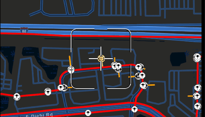
A field worker can create new features in a utility network by editing and snapping the vertices of a geometry to existing features on a map. In a gas utility network, gas pipeline features can be represented with the polyline geometry type. Utility networks use geometric coincident-based connectivity to provide pathways for resources. Rule-based snapping uses utility network connectivity rules when editing features based on their asset type and asset group to help maintain network connectivity.
How to use the sample
To edit a geometry, tap a point geometry to be edited in the map to select it. Then edit the geometry by tapping the button to start the geometry edito with the reticle tool.
Snap sources can be enabled and disabled. Snapping will not occur when SnapRuleBehavior.RulesPreventSnapping even when the source is enabled.
To interactively snap a vertex to a feature or graphic, ensure that snapping is enabled for the relevant snap source, tap the reticle to pick up the point geometry, then move the map to position the reticle nearby an existing feature or graphic. If the existing feature or graphic has valid utility network connectivity rules for the asset type that is being created or edited, the edit position will be adjusted to coincide with (or snap to) edges and vertices of its geometry. Tap again to place the vertex at the snapped location.
To discard changes and stop the geometry editor, press the discard button.
To save your edits, press the save button.
How it works
-
Create a map with
LoadSettings.FeatureTilingModeset toEnabledWithFullResolutionWhenSupported. -
Create a
Geodatabaseusing the mobile geodatabase file location. -
Display
Geodatabase.featureTableson the map using subtype feature layers. -
Create a
GeometryEditor, create aReticleVertexTooland set this ontoGeometryEditor.tool, and connect the editor to the map view. -
When editing a feature:
a. Call
SnapRules.create(UtilityNetwork, UtilityAssetType)to get the snap rules associated with a givenUtilityAssetType.b. Use
syncSourceSettings(SnapRules, SnapSourceEnablingBehavior.setFromRules)to populate thesnapSettings.sourceSettingswithSnapSourceSettingsenabling the sources with rules. -
Start the geometry editor with an existing geometry or
GeometryType.Point.
Relevant API
- FeatureLayer
- Geometry
- GeometryEditor
- GeometryEditorStyle
- GraphicsOverlay
- MapView
- ReticleVertexTool
- SnapRuleBehavior
- SnapRules
- SnapSettings
- SnapSource
- SnapSourceEnablingBehavior
- SnapSourceSettings
- UtilityNetwork
About the data
The Naperville gas network mobile geodatabase contains a utility network with a set of connectivity rules that can be used to perform geometry edits with rules based snapping.
Tags
edit, feature, geometry editor, graphics, layers, map, reticle, snapping, utility network
Sample Code
/* Copyright 2025 Esri
*
* Licensed under the Apache License, Version 2.0 (the "License");
* you may not use this file except in compliance with the License.
* You may obtain a copy of the License at
*
* http://www.apache.org/licenses/LICENSE-2.0
*
* Unless required by applicable law or agreed to in writing, software
* distributed under the License is distributed on an "AS IS" BASIS,
* WITHOUT WARRANTIES OR CONDITIONS OF ANY KIND, either express or implied.
* See the License for the specific language governing permissions and
* limitations under the License.
*
*/
package com.esri.arcgismaps.sample.snapgeometryeditswithutilitynetworkrules.components
import android.app.Application
import android.graphics.drawable.BitmapDrawable
import androidx.compose.ui.unit.dp
import androidx.lifecycle.AndroidViewModel
import androidx.lifecycle.viewModelScope
import com.arcgismaps.Color
import com.arcgismaps.data.ArcGISFeature
import com.arcgismaps.data.ArcGISFeatureTable
import com.arcgismaps.data.Geodatabase
import com.arcgismaps.data.GeodatabaseFeatureTable
import com.arcgismaps.geometry.Geometry
import com.arcgismaps.geometry.GeometryType
import com.arcgismaps.geometry.Point
import com.arcgismaps.geometry.SpatialReference
import com.arcgismaps.mapping.ArcGISMap
import com.arcgismaps.mapping.BasemapStyle
import com.arcgismaps.mapping.Viewpoint
import com.arcgismaps.mapping.layers.FeatureLayer
import com.arcgismaps.mapping.layers.FeatureTilingMode
import com.arcgismaps.mapping.layers.SubtypeFeatureLayer
import com.arcgismaps.mapping.layers.SubtypeSublayer
import com.arcgismaps.mapping.symbology.Renderer
import com.arcgismaps.mapping.symbology.SimpleLineSymbol
import com.arcgismaps.mapping.symbology.SimpleLineSymbolStyle
import com.arcgismaps.mapping.symbology.SimpleRenderer
import com.arcgismaps.mapping.symbology.Symbol
import com.arcgismaps.mapping.view.Graphic
import com.arcgismaps.mapping.view.GraphicsOverlay
import com.arcgismaps.mapping.view.SingleTapConfirmedEvent
import com.arcgismaps.mapping.view.geometryeditor.GeometryEditor
import com.arcgismaps.mapping.view.geometryeditor.ReticleVertexTool
import com.arcgismaps.mapping.view.geometryeditor.SnapRuleBehavior
import com.arcgismaps.mapping.view.geometryeditor.SnapRules
import com.arcgismaps.mapping.view.geometryeditor.SnapSourceEnablingBehavior
import com.arcgismaps.mapping.view.geometryeditor.SnapSourceSettings
import com.arcgismaps.toolkit.geoviewcompose.MapViewProxy
import com.arcgismaps.utilitynetworks.UtilityAssetType
import com.esri.arcgismaps.sample.sampleslib.components.MessageDialogViewModel
import com.esri.arcgismaps.sample.snapgeometryeditswithutilitynetworkrules.R
import kotlinx.coroutines.flow.MutableStateFlow
import kotlinx.coroutines.flow.asStateFlow
import kotlinx.coroutines.launch
import java.io.File
class SnapGeometryEditsWithUtilityNetworkRulesViewModel(application: Application) : AndroidViewModel(application) {
// Define the map view proxy and map with basemap and initial extent
val mapViewProxy = MapViewProxy()
val arcGISMap = ArcGISMap(basemapStyle = BasemapStyle.ArcGISStreetsNight).apply {
// Geodatabase layers are always full extent, however if using feature service layers, we
// must ensure that tiles use full resolution in order to snap to features
loadSettings.featureTilingMode = FeatureTilingMode.EnabledWithFullResolutionWhenSupported
initialViewpoint = Viewpoint(
center = Point(-9811055.156028448, 5131792.19502501, SpatialReference.webMercator()),
scale = 1e4
)
}
// Get the file path of the geodatabase file
private val provisionPath: String by lazy {
application.getExternalFilesDir(null)?.path.toString() + File.separator +
application.getString(R.string.snap_geometry_edits_with_utility_network_rules_app_name)
}
private val filePath = provisionPath + application.getString(R.string.naperville_geodatabase)
// Create the mobile map package
private val geodatabase = Geodatabase(filePath)
// Hold references to the subtype sublayers for the distribution and service pipe layers
private var distributionPipeLayer: SubtypeSublayer? = null
private var servicePipeLayer: SubtypeSublayer? = null
private val pipelineLayerName = application.getString(R.string.pipeline_layer_name)
private val distributionPipeName = application.getString(R.string.distribution_pipe_name)
private val servicePipeLayerName = application.getString(R.string.service_pipe_layer_name)
// Message dialog view model for handling error messages
val messageDialogVM = MessageDialogViewModel()
// Symbols to help visualize the snap rules behaviors
private val rulesPreventSymbol: Symbol =
SimpleLineSymbol(SimpleLineSymbolStyle.Solid, Color.red, 4f)
private val rulesLimitSymbol: Symbol =
SimpleLineSymbol(SimpleLineSymbolStyle.Solid, Color.fromRgba(255, 165, 0 ), 3f)
private val noneSymbol: Symbol =
SimpleLineSymbol(SimpleLineSymbolStyle.Dash, Color.green, 3f)
private val symbols = mutableMapOf(
SnapRuleBehavior.RulesPreventSnapping to rulesPreventSymbol,
SnapRuleBehavior.RulesLimitSnapping to rulesLimitSymbol,
SnapRuleBehavior.None to noneSymbol
)
private val symbolSwatches = mutableMapOf<SnapRuleBehavior, BitmapDrawable?>()
// Save default renderers to reset the layers when a feature selection is cleared
private var defaultDistributionRenderer: Renderer? = null
private var defaultServiceRenderer: Renderer? = null
// Define a geometry editor with a snapping enabled. A reticle tool is ideal for touch devices.
val geometryEditor = GeometryEditor().apply {
snapSettings.isEnabled = true
snapSettings.isFeatureSnappingEnabled = true
tool = ReticleVertexTool()
}
// Define a graphics overlay which can also act as a snap source
private val defaultGraphicRenderer = SimpleRenderer(SimpleLineSymbol(
SimpleLineSymbolStyle.Dash, Color.fromRgba(165, 165, 165), 3f))
val graphicsOverlay = GraphicsOverlay(
graphics = listOf(Graphic(Geometry.fromJsonOrNull(application.getString(R.string.graphic_geometry_json))))
).apply {
id = application.getString(R.string.graphics_overlay_id)
renderer = defaultGraphicRenderer
}
// Hold a reference to a selected feature and its related asset group and type
private var selectedFeature: ArcGISFeature? = null
private val _assetGroupNameState = MutableStateFlow("<Nothing selected>")
val assetGroupNameState = _assetGroupNameState.asStateFlow()
private val _assetTypeNameState = MutableStateFlow("<Nothing selected>")
val assetTypeNameState = _assetTypeNameState.asStateFlow()
// Represents the snap source settings object (for enabling and disabling), along with a name
// to use in the UI, and a symbol swatch
data class SnapSourceProperty(
val name: String,
val swatch: BitmapDrawable,
val snapSourceSettings: SnapSourceSettings
)
private val _snapSourcePropertyList = MutableStateFlow(listOf<SnapSourceProperty>())
val snapSourcePropertyList = _snapSourcePropertyList.asStateFlow()
// Create boolean flags to track the state of UI components
private val _isEditButtonEnabled = MutableStateFlow(false)
internal val isEditButtonEnabled = _isEditButtonEnabled.asStateFlow()
init {
viewModelScope.launch {
arcGISMap.load().onFailure { error ->
messageDialogVM.showMessageDialog(error)
}
// Load the mobile map package
geodatabase.load().onSuccess {
// Add layers from the geodatabase to the map
addLayersToMapFromGeodatabase(application)
// Set the utility network on the map and load it
arcGISMap.utilityNetworks.add(geodatabase.utilityNetworks.first())
arcGISMap.utilityNetworks.first().load().onFailure {
messageDialogVM.showMessageDialog(it)
}
// Set up symbol swatches
symbolSwatches[SnapRuleBehavior.RulesPreventSnapping] = createSwatch(rulesPreventSymbol)
symbolSwatches[SnapRuleBehavior.RulesLimitSnapping] = createSwatch(rulesLimitSymbol)
symbolSwatches[SnapRuleBehavior.None] = createSwatch(noneSymbol)
}.onFailure {
messageDialogVM.showMessageDialog(it)
}
}
}
/**
* Start the geometry editor to edit the geometry of the selected feature.
*/
private fun editFeatureGeometry() {
// Get the symbol for the selected feature
selectedFeature?.let { feature ->
// Get the geodatabase feature table of the selected feature
val featureTable = (feature.featureTable as? GeodatabaseFeatureTable) ?: return
// Use the symbol from the selected feature in the style of the geometry editor tool
val symbol = featureTable.layerInfo?.drawingInfo?.renderer?.getSymbol(feature)
geometryEditor.tool.style.apply {
vertexSymbol = symbol
feedbackVertexSymbol = symbol
selectedVertexSymbol = symbol
vertexTextSymbol = null
}
// Hide the selected feature
(featureTable.layer as? FeatureLayer)?.setFeatureVisible(feature, false)
// Start the geometry editor and center the map underneath the reticle
feature.geometry?.let { initialGeometry ->
viewModelScope.launch {
mapViewProxy.setViewpointCenter(initialGeometry.extent.center)
}
geometryEditor.start(initialGeometry)
geometryEditor.selectVertex(0,0)
}
}
}
/**
* Stop the geometry editor and discard the changes made to the geometry.
*/
fun discardGeometryChanges() {
// Discard the current edit
geometryEditor.stop()
// Reset the selection
resetSelections()
}
/**
* Stop the geometry editor, and update the previously identified feature with the new geometry.
*/
fun saveGeometryChanges() {
// Stop the geometry editor and get the updated geometry
val finalGeometry = geometryEditor.stop()
// Update the feature with the new geometry
selectedFeature?.let { feature ->
feature.geometry = finalGeometry
viewModelScope.launch {
(feature.featureTable as? GeodatabaseFeatureTable)?.updateFeature(feature)
?.onFailure { error -> messageDialogVM.showMessageDialog(error) }
}
}
// Reset the selection
resetSelections()
}
/**
* Identifies the tapped screen coordinate in the provided [singleTapConfirmedEvent] and gets
* the asset at that location.
*/
fun identify(singleTapConfirmedEvent: SingleTapConfirmedEvent) {
if (geometryEditor.isStarted.value || arcGISMap.operationalLayers.isEmpty()) {
return
}
viewModelScope.launch {
mapViewProxy.identifyLayers(
screenCoordinate = singleTapConfirmedEvent.screenCoordinate,
tolerance = 12.dp,
returnPopupsOnly = false,
maximumResults = 1
).onSuccess { identifyResultList ->
// As we are using subtype feature layers in this sample the returned features are
// contained in the sublayer results
val identifiedFeature = identifyResultList.firstOrNull()?.sublayerResults?.firstOrNull()?.geoElements?.firstOrNull()
if (identifiedFeature !is ArcGISFeature) {
return@launch resetSelections()
}
// In this sample we only allow selection of point features. If the identified
// feature is null or the feature is not a point feature then reset and return.
if (identifiedFeature.featureTable?.geometryType != GeometryType.Point) {
return@launch resetSelections()
} else if (
selectedFeature != null
&& identifiedFeature != selectedFeature
&& selectedFeature?.featureTable?.layer is FeatureLayer
) {
// If a feature is already selected and the tapped feature is not the selected
// feature then clear the previous selection
(selectedFeature?.featureTable?.layer as? FeatureLayer)?.clearSelection()
}
// Update the selected feature and select it on the layer
selectedFeature = identifiedFeature
selectedFeature?.let { feature ->
(feature.featureTable?.layer as? FeatureLayer)?.selectFeature(feature)
// Create a utility element for the selected feature using the utility network
arcGISMap.utilityNetworks.first().createElementOrNull(feature)?.let { element ->
// Update values for UI based on the selected feature
_assetGroupNameState.value = element.assetGroup.name
_assetTypeNameState.value = element.assetType.name
_isEditButtonEnabled.value = true
setSnapSettings(element.assetType)
} ?: return@launch messageDialogVM.showMessageDialog("Error creating UtilityElement")
// Start the editing session once feature is selected.
editFeatureGeometry()
}
}
}
}
/**
* Creates [SnapRules] based on the given asset type, synchronizes the snap sources using these
* rules, then updates the snap sources list used by the UI.
*/
private suspend fun setSnapSettings(assetType: UtilityAssetType) {
// Get the snap rules associated with the asset type
val snapRules = SnapRules.create(arcGISMap.utilityNetworks.first(), assetType).getOrElse {
return messageDialogVM.showMessageDialog(it)
}
geometryEditor.snapSettings.apply {
// Synchronize the snap source collection with the map's operational layers using the snap
// rules. Setting SnapSourceEnablingBehavior.SetFromRules will enable snapping for the
// layers and sublayers specified in the snap rules.
syncSourceSettings(snapRules, SnapSourceEnablingBehavior.SetFromRules)
// Enable snapping for the graphics overlay as this will not be affected by the given
// SnapSourceEnablingBehavior.setFromRules
sourceSettings.first { it.source == graphicsOverlay }.isEnabled = true
}
updateSnapSourceList()
}
/**
* Updates the enabled value of the [SnapSourceSettings] object at the given index and rebuilds
* the snap source list.
*/
fun setSnapSourceCheckedValue(checkedValue: Boolean, index: Int) {
// Set new value into appropriate property via index
_snapSourcePropertyList.value[index].snapSourceSettings.isEnabled = checkedValue
updateSnapSourceList()
}
/**
* Updates the lists used by the UI to show SnapSourceSettings information.
*/
private fun updateSnapSourceList() {
// Update the backing list with a new list of current properties from snapSettings
_snapSourcePropertyList.value = currentSnapSourcePropertyList()
}
/**
* Returns a list of [SnapSourceProperty] objects based on the current snap sources.
*/
private fun currentSnapSourcePropertyList(): List<SnapSourceProperty> {
return buildList {
geometryEditor.snapSettings.sourceSettings.forEach { sourceSettings ->
when (sourceSettings.source) {
is GraphicsOverlay -> {
symbolSwatches[sourceSettings.ruleBehavior]?.let { swatch ->
add(SnapSourceProperty((sourceSettings.source as GraphicsOverlay).id, swatch, sourceSettings))
}
// Set the appropriate symbol for the layer based on the SnapRuleBehavior.
graphicsOverlay.renderer = SimpleRenderer(symbols[sourceSettings.ruleBehavior])
}
is SubtypeFeatureLayer -> {
sourceSettings.childSourceSettings.forEach { childSourceSettings ->
(childSourceSettings.source as? SubtypeSublayer)?.let { childSource ->
when (childSource.name) {
distributionPipeName, servicePipeLayerName -> {
symbolSwatches[childSourceSettings.ruleBehavior]?.let { swatch ->
add(SnapSourceProperty(childSource.name, swatch, childSourceSettings))
}
// Set the appropriate symbol for the sublayer based on the SnapRuleBehavior.
childSource.renderer =
SimpleRenderer(symbols[childSourceSettings.ruleBehavior])
}
}
}
}
}
}
}
}
}
/**
* Clears the selection on the layer and reinstates feature visibility, then resets the selected
* feature and layer and any UI backing variables.
*/
private fun resetSelections() {
// Clear the existing selection and show the selected feature
selectedFeature?.let { feature ->
(feature.featureTable?.layer as? FeatureLayer)?.let {
it.clearSelection()
it.setFeatureVisible(feature = feature, visible = true)
}
}
// Reset the selected feature and layer
selectedFeature = null
_assetGroupNameState.value = "<Nothing selected>"
_assetTypeNameState.value = "<Nothing selected>"
_isEditButtonEnabled.value = false
// Revert back to the default renderer for the distribution and service pipe layers and
// graphics overlay
distributionPipeLayer?.renderer = defaultDistributionRenderer
servicePipeLayer?.renderer = defaultServiceRenderer
graphicsOverlay.renderer = defaultGraphicRenderer
// Clear the snap sources list
_snapSourcePropertyList.value = emptyList()
}
/**
* Adds required layers from the geodatabase to the map, setting the visibility of sublayers to
* show only a small subset in order to avoid too much visual clutter.
*/
private suspend fun addLayersToMapFromGeodatabase(application: Application) {
// Only show the Distribution Pipe and Service Pipe sublayers in the pipeline layer. Also
// store the default renderer for the these sublayers.
val pipeLayer = SubtypeFeatureLayer(
geodatabase.getFeatureTable(pipelineLayerName) as ArcGISFeatureTable
)
pipeLayer.load().getOrElse {
messageDialogVM.showMessageDialog(
"Error loading pipeline layer",
it.message.toString()
)
}
val distributionPipeName = application.getString(R.string.distribution_pipe_name)
val servicePipeLayerName = application.getString(R.string.service_pipe_layer_name)
// Set the visibility of the sublayers and store the default renderer for the distribution
// and service pipe layers.
pipeLayer.subtypeSublayers.forEach { sublayer ->
when (sublayer.name) {
distributionPipeName -> {
distributionPipeLayer = sublayer
defaultDistributionRenderer = sublayer.renderer
}
servicePipeLayerName -> {
servicePipeLayer = sublayer
defaultServiceRenderer = sublayer.renderer
}
else -> {
// Hide all other sublayers
sublayer.isVisible = false
}
}
}
arcGISMap.operationalLayers.add(pipeLayer)
// Only show the Excess Flow Valve and Controllable Tee sublayers in the device layer
val deviceLayer = SubtypeFeatureLayer(
geodatabase.getFeatureTable(
application.getString(R.string.device_layer_name)
) as ArcGISFeatureTable
)
deviceLayer.load().getOrElse {
messageDialogVM.showMessageDialog(
"Error loading pipeline layer",
it.message.toString()
)
}
val excessFlowValveName = application.getString(R.string.excess_flow_valve_name)
val controllableTeeName = application.getString(R.string.controllable_tee_name)
// Hide all sublayers that aren't excess flow valves or controllable tees
deviceLayer.subtypeSublayers.filter { sublayer ->
sublayer.name != excessFlowValveName && sublayer.name != controllableTeeName
}.forEach { sublayerToHide ->
sublayerToHide.isVisible = false
}
// Add the device layer to the map
arcGISMap.operationalLayers.add(deviceLayer)
val junctionLayer = (geodatabase.getFeatureTable(
tableName = application.getString(R.string.junction_layer_name)
) as? ArcGISFeatureTable)?.let { junctionFeatureTable ->
SubtypeFeatureLayer(featureTable = junctionFeatureTable)
} ?: return messageDialogVM.showMessageDialog("Error retrieving junction layer")
// Add the junction layer to the map
arcGISMap.operationalLayers.add(junctionLayer)
}
/**
* Create a swatch from the given symbol.
*/
private suspend fun createSwatch(symbol: Symbol): BitmapDrawable? {
// Create a swatch from the symbol
val swatch = symbol.createSwatch(
screenScale = 30.0f,
width = 4.0f,
height = 4.0f
).getOrNull()
return swatch
}
}