Learn how to download and display an offline map for a user-defined geographical area of a web map.
Offline maps allow users to continue working when network connectivity is poor or lost. If a web map is enabled for offline use, a user can request that ArcGIS generates an offline map for a specified geographic area of interest.
In this tutorial, you will download an offline map for an area of interest from the web map of the stormwater network within Naperville, IL, USA . You can then use this offline map without a network connection.
Prerequisites
Before starting this tutorial:
-
You need an ArcGIS Location Platform or ArcGIS Online account.
-
Your system meets the system requirements.
-
The ArcGIS Maps SDK for Qt, version 200.8.0 or later is installed.
-
The Qt 6.8.2 software development framework or later is installed.
Get the web map item ID
You can use ArcGIS tools to create and view web maps. Use the Map Viewer to identify the web map item ID. This item ID will be used later in the tutorial.
- Go to the Naperville water network in the Map Viewer in ArcGIS Online. This web map displays stormwater network within Naperville, IL, USA .
- Make a note of the item ID at the end of the browser's URL. The item ID should be:
acc027394bc84c2fb04d1ed317aac674
Develop or Download
You have two options for completing this tutorial:
Option 1: Develop the code
Open a Qt Creator project
-
Open the project you created by completing the Display a map tutorial.
-
Continue with the following instructions to display an offline map.
Update the header file
You can display a web map using the web map's item ID. Create a map from the web map portal item, and display it in your app.
-
In Projects, double-click Headers > Display_a_map.h to open the file. Add the following classes to the header file.
Display_a_map.hUse dark colors for code blocks namespace Esri::ArcGISRuntime { class Map; class MapQuickView; class PortalItem; class OfflineMapTask; -
Remove the unnecessary declaration for the
setfunction.Viewpoint() Display_a_map.hUse dark colors for code blocks private: Esri::ArcGISRuntime::MapQuickView* mapView() const; void setMapView(Esri::ArcGISRuntime::MapQuickView* mapView); void setupViewpoint(); Esri::ArcGISRuntime::Map* m_map = nullptr; Esri::ArcGISRuntime::MapQuickView* m_mapView = nullptr; }; -
Add the
generatefunction declaration and member variablesMap By Extent() mand_portal Item m. Then save the file._offline Map Task Display_a_map.hUse dark colors for code blocks private: Esri::ArcGISRuntime::MapQuickView* mapView() const; void setMapView(Esri::ArcGISRuntime::MapQuickView* mapView); void generateMapByExtent(); Esri::ArcGISRuntime::Map* m_map = nullptr; Esri::ArcGISRuntime::MapQuickView* m_mapView = nullptr; Esri::ArcGISRuntime::PortalItem* m_portalItem = nullptr; Esri::ArcGISRuntime::OfflineMapTask* m_offlineMapTask = nullptr;
Update include statements
-
In the Projects window, open the Sources folder and then open the Display_a_map.cpp file. Remove the following unneeded include statements.
Display_a_map.cppUse dark colors for code blocks #include "Display_a_map.h" #include "Map.h" #include "MapTypes.h" #include "MapQuickView.h" #include "Point.h" #include "Viewpoint.h" #include "SpatialReference.h" #include <QFuture> -
Add the following new include statements.
Display_a_map.cppUse dark colors for code blocks #include "Display_a_map.h" #include "Map.h" #include "MapQuickView.h" #include "SpatialReference.h" #include <QFuture> #include "Envelope.h" #include "EnvelopeBuilder.h" #include "Error.h" #include "GenerateOfflineMapParameters.h" #include "GenerateOfflineMapJob.h" #include "GenerateOfflineMapResult.h" #include "Graphic.h" #include "GraphicListModel.h" #include "GraphicsOverlay.h" #include "GraphicsOverlayListModel.h" #include "OfflineMapTask.h" #include "Portal.h" #include "PortalItem.h" #include "SimpleFillSymbol.h" #include "SimpleLineSymbol.h" #include "SymbolTypes.h" #include "TaskTypes.h" #include <QDir> #include <QUuid>
Remove remaining unneeded code
At this point we will remove the additional unnecessary code before we add the logic for the rest of the app.
-
Continuing on the Display_a_map.cpp file, remove the
setupmethod.Viewpoint() Display_a_map.cppUse dark colors for code blocks void Display_a_map::setupViewpoint() { const Point center(-118.80543, 34.02700, SpatialReference::wgs84()); const Viewpoint viewpoint(center, 100000.0); m_mapView->setViewpointAsync(viewpoint); } -
Remove the call to the
setupmethod from within theViewpoint() setfunction.Map View( Map Quick View* map View) Display_a_map.cppUse dark colors for code blocks // Set the view (created in QML) void Display_a_map::setMapView(MapQuickView* mapView) { if (!mapView || mapView == m_mapView) { return; } m_mapView = mapView; m_mapView->setMap(m_map); setupViewpoint(); emit mapViewChanged(); }
Update the constructor
At this point you will update the constructor in the app.
-
Still editing the Display_a_map.cpp file, remove the comma after
Qand then modify the constructor to remove initialization withObject(parent) Basemapand theStyle Map.Display_a_map.cppUse dark colors for code blocks Display_a_map::Display_a_map(QObject* parent /* = nullptr */): QObject(parent), m_map(new Map(BasemapStyle::ArcGISTopographic, this)) -
Inside the body of the constructor, add code to Instantiate a
Portaland from that, aPortalItemusing the web map item ID for the Naperville water network. Use that to create a newMap. Then create a newOfflineMapTaskreferencing that portal item.Display_a_map.cppUse dark colors for code blocks Display_a_map::Display_a_map(QObject* parent /* = nullptr */): QObject(parent) { Portal* portal = new Portal(false, this); m_portalItem = new PortalItem(portal, "acc027394bc84c2fb04d1ed317aac674", this); m_map = new Map(m_portalItem, this); m_offlineMapTask = new OfflineMapTask(m_portalItem, this);
Specify the area of the web map to take offline
-
Continuing on the Display_a_map.cpp file, add the call to
generatemethod within theMap By Extent() setfunction. The next step implements this method.Map View( Map Quick View* map View) Display_a_map.cppUse dark colors for code blocks // Set the view (created in QML) void Display_a_map::setMapView(MapQuickView* mapView) { if (!mapView || mapView == m_mapView) { return; } m_mapView = mapView; m_mapView->setMap(m_map); generateMapByExtent(); emit mapViewChanged(); } -
Begin to implement the
generatefunction. UseMap By Extent() EnvelopeBuilderto set four parameters and then calltoto create the envelope. Add this new function near the bottom of the file.Envelope() Display_a_map.cppUse dark colors for code blocks void Display_a_map::generateMapByExtent() { // Create envelope to define area of interest EnvelopeBuilder* envelopeBuilder = new EnvelopeBuilder(SpatialReference::wgs84(), this); envelopeBuilder->setXMin(-88.1526); envelopeBuilder->setXMax(-88.1490); envelopeBuilder->setYMin(41.7694); envelopeBuilder->setYMax(41.7714); Envelope offlineArea = envelopeBuilder->toEnvelope(); } -
Add a graphic to
generateto show the area you will take offline.Map By Extent() Create a
Graphicusing the envelope,SimpleFillSymbolandSimpleLineSymbol. From this create aGraphicsOverlayand add it to the mapView.Display_a_map.cppUse dark colors for code blocks void Display_a_map::generateMapByExtent() { // Create envelope to define area of interest EnvelopeBuilder* envelopeBuilder = new EnvelopeBuilder(SpatialReference::wgs84(), this); envelopeBuilder->setXMin(-88.1526); envelopeBuilder->setXMax(-88.1490); envelopeBuilder->setYMin(41.7694); envelopeBuilder->setYMax(41.7714); Envelope offlineArea = envelopeBuilder->toEnvelope(); Graphic* box = new Graphic(offlineArea, new SimpleFillSymbol(SimpleFillSymbolStyle::Solid, Qt::transparent, new SimpleLineSymbol(SimpleLineSymbolStyle::Solid, Qt::red, 3, this), this), this); GraphicsOverlay* boxOverlay = new GraphicsOverlay(this); boxOverlay->graphics()->append(box); // add graphics overlay to the map view m_mapView->graphicsOverlays()->append(boxOverlay); }
Download and display the offline map
-
Add the following
createmethod that creates aDefault Generate Offline Map Parameters Async Generateobject. These offline map parameters will serve as the input to create aOffline Map Parameters GenerateOfflineMapJob. Store the resulting offline mobile map package (MMPK) in a location on your development machine. It is important that you specify the folder location that exists on the device and that it matches the code for the outputPath variable.Display_a_map.cppUse dark colors for code blocks void Display_a_map::generateMapByExtent() { // Create envelope to define area of interest EnvelopeBuilder* envelopeBuilder = new EnvelopeBuilder(SpatialReference::wgs84(), this); envelopeBuilder->setXMin(-88.1526); envelopeBuilder->setXMax(-88.1490); envelopeBuilder->setYMin(41.7694); envelopeBuilder->setYMax(41.7714); Envelope offlineArea = envelopeBuilder->toEnvelope(); Graphic* box = new Graphic(offlineArea, new SimpleFillSymbol(SimpleFillSymbolStyle::Solid, Qt::transparent, new SimpleLineSymbol(SimpleLineSymbolStyle::Solid, Qt::red, 3, this), this), this); GraphicsOverlay* boxOverlay = new GraphicsOverlay(this); boxOverlay->graphics()->append(box); // add graphics overlay to the map view m_mapView->graphicsOverlays()->append(boxOverlay); // generate the offline map parameters m_offlineMapTask->createDefaultGenerateOfflineMapParametersAsync(offlineArea).then(this,[this](const GenerateOfflineMapParameters& params) { // Generate the offline map. Store the .mmpk in the desired location. const QString outputPath = "ENTER_PATH_TO_MMPK_FILE/offlinemap.mmpk"; // Ex: "C:/mmpk_folder/offlinemap.mmpk" GenerateOfflineMapJob* generateJob = m_offlineMapTask->generateOfflineMap(params, outputPath); if (!generateJob) return; } -
Add a
connectthat monitors the status of theGenerateOfflineMapJoband returns changes to status.Display_a_map.cppUse dark colors for code blocks void Display_a_map::generateMapByExtent() { // Create envelope to define area of interest EnvelopeBuilder* envelopeBuilder = new EnvelopeBuilder(SpatialReference::wgs84(), this); envelopeBuilder->setXMin(-88.1526); envelopeBuilder->setXMax(-88.1490); envelopeBuilder->setYMin(41.7694); envelopeBuilder->setYMax(41.7714); Envelope offlineArea = envelopeBuilder->toEnvelope(); Graphic* box = new Graphic(offlineArea, new SimpleFillSymbol(SimpleFillSymbolStyle::Solid, Qt::transparent, new SimpleLineSymbol(SimpleLineSymbolStyle::Solid, Qt::red, 3, this), this), this); GraphicsOverlay* boxOverlay = new GraphicsOverlay(this); boxOverlay->graphics()->append(box); // add graphics overlay to the map view m_mapView->graphicsOverlays()->append(boxOverlay); // generate the offline map parameters m_offlineMapTask->createDefaultGenerateOfflineMapParametersAsync(offlineArea).then(this,[this](const GenerateOfflineMapParameters& params) { // Generate the offline map. Store the .mmpk in the desired location. const QString outputPath = "ENTER_PATH_TO_MMPK_FILE/offlinemap.mmpk"; // Ex: "C:/mmpk_folder/offlinemap.mmpk" GenerateOfflineMapJob* generateJob = m_offlineMapTask->generateOfflineMap(params, outputPath); if (!generateJob) return; // use connect to monitor job status for changes and return job status connect(generateJob, &GenerateOfflineMapJob::statusChanged, this, [this, generateJob]() { if (generateJob->jobStatus() == JobStatus::Succeeded) { qDebug() << "generating offline map"; m_mapView->setMap(generateJob->result()->offlineMap(this)); qDebug() << (generateJob->error().isEmpty() ? "No errors" : (generateJob->error().message() + generateJob->error().additionalMessage())); } else if (generateJob->jobStatus() == JobStatus::Failed) { qWarning() << generateJob->error().message() << generateJob->error().additionalMessage(); } }); } -
Finally, add another
connectthat displays progress of theGenerateOfflineMapJobas the job executes. Then add code for thegenerate.Job- >start() Display_a_map.cppUse dark colors for code blocks void Display_a_map::generateMapByExtent() { // Create envelope to define area of interest EnvelopeBuilder* envelopeBuilder = new EnvelopeBuilder(SpatialReference::wgs84(), this); envelopeBuilder->setXMin(-88.1526); envelopeBuilder->setXMax(-88.1490); envelopeBuilder->setYMin(41.7694); envelopeBuilder->setYMax(41.7714); Envelope offlineArea = envelopeBuilder->toEnvelope(); Graphic* box = new Graphic(offlineArea, new SimpleFillSymbol(SimpleFillSymbolStyle::Solid, Qt::transparent, new SimpleLineSymbol(SimpleLineSymbolStyle::Solid, Qt::red, 3, this), this), this); GraphicsOverlay* boxOverlay = new GraphicsOverlay(this); boxOverlay->graphics()->append(box); // add graphics overlay to the map view m_mapView->graphicsOverlays()->append(boxOverlay); // generate the offline map parameters m_offlineMapTask->createDefaultGenerateOfflineMapParametersAsync(offlineArea).then(this,[this](const GenerateOfflineMapParameters& params) { // Generate the offline map. Store the .mmpk in the desired location. const QString outputPath = "ENTER_PATH_TO_MMPK_FILE/offlinemap.mmpk"; // Ex: "C:/mmpk_folder/offlinemap.mmpk" GenerateOfflineMapJob* generateJob = m_offlineMapTask->generateOfflineMap(params, outputPath); if (!generateJob) return; // use connect to monitor job status for changes and return job status connect(generateJob, &GenerateOfflineMapJob::statusChanged, this, [this, generateJob]() { if (generateJob->jobStatus() == JobStatus::Succeeded) { qDebug() << "generating offline map"; m_mapView->setMap(generateJob->result()->offlineMap(this)); qDebug() << (generateJob->error().isEmpty() ? "No errors" : (generateJob->error().message() + generateJob->error().additionalMessage())); } else if (generateJob->jobStatus() == JobStatus::Failed) { qWarning() << generateJob->error().message() << generateJob->error().additionalMessage(); } }); // use connect to monitor job progress changes and return progress return job progress connect(generateJob, &GenerateOfflineMapJob::progressChanged, this, [generateJob]() { qDebug() << "Job status:" << generateJob->progress() << "%"; }); generateJob->start(); }); }
Set developer credentials
For the final steps of this tutorial, click the tab below that corresponds to the authentication type (API key authentication or User authentication) that you chose when you completed the Display a map tutorial.
Be sure to also provide the same authentication (API key or user authentication Client ID/Redirect URL) that you used for the Display a map tutorial.
Set the API Key
-
In the project Sources folder of Qt Creator, open the main.cpp file.
-
Modify the code to set the
accessusing your API key access token (highlighted in yellow).Token main.cppUse dark colors for code blocks // The following methods grant an access token: // 1. User authentication: Grants a temporary access token associated with a user's ArcGIS account. // To generate a token, a user logs in to the app with an ArcGIS account that is part of an // organization in ArcGIS Online or ArcGIS Enterprise. // 2. API key authentication: Get a long-lived access token that gives your application access to // ArcGIS location services. Go to the tutorial at https://links.esri.com/create-an-api-key. // Copy the API Key access token. const QString accessToken = QString(""); if (accessToken.isEmpty()) { qWarning() << "Use of ArcGIS location services, such as the basemap styles service, requires" << "you to authenticate with an ArcGIS account or set the API Key property."; } else { ArcGISRuntimeEnvironment::setApiKey(accessToken); } -
Save the main.cpp file.
Best Practice: The access token is stored directly in the code as a convenience for this tutorial. Do not store credentials directly in source code in a production environment.
Press Ctrl + R to run the app.
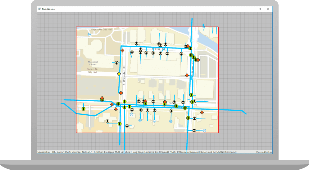
Initially, you should see the map of the stormwater network for Naperville, IL, USA, with a red outline as before. At the Application Output tab in Creator, the Job status percentage should increment up to 100%, and then you should see the offline map for the specified area of the stormwater network for Naperville, IL, USA. You should also be able to see the downloaded .mmpk file on the device hard drive for the output variable you specified in the code. Remove your network connection and you will still be able to use the mouse to drag, scroll, and double-click the map view to explore this offline map.
Alternatively, you can download the tutorial solution, as follows.
Option 2: Download the solution
-
Click the
Download solutionlink underSolutionand unzip the file to a location on your machine. -
Open the .pro project file in Qt Creator.
Since the downloaded solution does not contain authentication credentials, you must set up authentication to create the developer credentials and add them to the project.
In the project Sources folder of Qt Creator, open the Display_a_map.cpp file.
You will need to store the resulting offline mobile map package (MMPK) in a location on your development machine. It is important that you specify the folder location that exists on the device and that it matches the code for the outputPath variable. The code line you need to modify is found in the generate method and is highlighted in yellow.
// generate the offline map parameters
m_offlineMapTask->createDefaultGenerateOfflineMapParametersAsync(offlineArea).then(this,[this](const GenerateOfflineMapParameters& params)
{
// Generate the offline map. Store the .mmpk in the desired location.
const QString outputPath = "ENTER_PATH_TO_MMPK_FILE/offlinemap.mmpk"; // Ex: "C:/mmpk_folder/offlinemap.mmpk"
GenerateOfflineMapJob* generateJob = m_offlineMapTask->generateOfflineMap(params, outputPath);
if (!generateJob)
return;
For the final steps of this tutorial, click the tab below that corresponds to the authentication type (API key authentication or User authentication) that you chose when you completed the Display a map tutorial.
Be sure to also provide the same authentication (API key or user authentication Client ID/Redirect URL) that you used for the Display a map tutorial.
Set developer credentials in the solution
Set the API Key
-
In the project Sources folder of Qt Creator, open the main.cpp file.
-
Modify the code to set the
accessusing your API key access token (highlighted in yellow).Token main.cppUse dark colors for code blocks // The following methods grant an access token: // 1. User authentication: Grants a temporary access token associated with a user's ArcGIS account. // To generate a token, a user logs in to the app with an ArcGIS account that is part of an // organization in ArcGIS Online or ArcGIS Enterprise. // 2. API key authentication: Get a long-lived access token that gives your application access to // ArcGIS location services. Go to the tutorial at https://links.esri.com/create-an-api-key. // Copy the API Key access token. const QString accessToken = QString(""); if (accessToken.isEmpty()) { qWarning() << "Use of ArcGIS location services, such as the basemap styles service, requires" << "you to authenticate with an ArcGIS account or set the API Key property."; } else { ArcGISRuntimeEnvironment::setApiKey(accessToken); } -
Save main.cpp file.
Best Practice: The access token is stored directly in the code as a convenience for this tutorial. Do not store credentials directly in source code in a production environment.
Run the app
Press Ctrl + R to run the app.
Initially, you should see the map of the stormwater network for Naperville, IL, USA, with a red outline as before. At the Application Output tab in Creator, the Job status percentage should increment up to 100%, and then you should see the offline map for the specified area of the stormwater network for Naperville, IL, USA. You should also be able to see the downloaded .mmpk file on the device hard drive for the output variable you specified in the code. Remove your network connection and you will still be able to use the mouse to drag, scroll, and double-click the map view to explore this offline map.
What's next?
Learn how to use additional API features, ArcGIS location services, and ArcGIS tools in these tutorials: