Learn how to use a URL to access and
display a feature layer
A map
A feature layerx,y coordinates and a spatial reference.
Prerequisites
Before starting this tutorial:
-
You need an ArcGIS Location Platform or ArcGIS Online account.
-
Your system meets the system requirements.
-
The ArcGIS Maps SDK for Qt, version 300.0.0 or later is installed.
-
The Qt 6.8.2 software development framework or later is installed.
Develop or Download
You have two options for completing this tutorial:
Option 1: Develop the code
To start the tutorial, complete the Display a map tutorial. This creates a map to display the Santa Monica Mountains in California using the topographic basemap from the ArcGIS Basemap Styles service
Open a Qt Creator project
- Open the project you created by completing the Display a map tutorial.
- Continue with the following instructions to use a URL to access and display a feature layer in a map.
Include header files
-
In the project Headers folder of Qt Creator, double-click the Display_a_map.cpp file to open it. Include these header files to be able to create
ServiceFeatureTableandFeatureLayerinstances.Display-a-map.cpp#include "Display_a_map.h"#include "Map.h"#include "MapTypes.h"#include "MapQuickView.h"#include "Point.h"#include "Viewpoint.h"#include "SpatialReference.h"#include <QFuture>#include "LayerListModel.h"#include "ServiceFeatureTable.h"#include "FeatureLayer.h"
Add a polygon feature layer
This tutorial will draw the map in following order:
- ArcGISTopographic basemap style layer
- Parks and Open Spaces (polygons)
- Trails (lines)
- Trailheads (points)
It is important to add feature layers in the correct order so features are displayed correctly. Polygon feature layers
Use the FeatureLayer class to reference the Parks and Open Spaces URL and add features to the map
-
Go to the Parks and Open Spaces URL and browse the properties of the layer. You may want to explore the Name, Type, Drawing Info, and Fields properties.
-
Within the
setupViewpoint()method, add the following code. Create aQUrlinstance namedpolygonFeatureUrlusing an ArcGIS feature server as the feature data source. Then create aServiceFeatureTablenamedpolygon_feature_tablefrom thatQUrl.Display-a-map.cppvoid Display_a_map::setupViewpoint(){const Point center(-118.80543, 34.02700, SpatialReference::wgs84());const Viewpoint viewpoint(center, 100000.0);m_mapView->setViewpointAsync(viewpoint);const QUrl polygonFeatureUrl("https://services3.arcgis.com/GVgbJbqm8hXASVYi/ArcGIS/rest/services/Parks_and_Open_Space/FeatureServer/0");ServiceFeatureTable* polygon_feature_table = new ServiceFeatureTable(polygonFeatureUrl, this);} -
Continuing within the
setupViewpoint()method, you will create aFeatureLayerinstance namedpolygon_feature_layer, passing inpolygon_feature_tableas the argument. Then append your newpolygon_feature_layerto theMapinstance namedm_map.Display-a-map.cppvoid Display_a_map::setupViewpoint(){const Point center(-118.80543, 34.02700, SpatialReference::wgs84());const Viewpoint viewpoint(center, 100000.0);m_mapView->setViewpointAsync(viewpoint);const QUrl polygonFeatureUrl("https://services3.arcgis.com/GVgbJbqm8hXASVYi/ArcGIS/rest/services/Parks_and_Open_Space/FeatureServer/0");ServiceFeatureTable* polygon_feature_table = new ServiceFeatureTable(polygonFeatureUrl, this);FeatureLayer* polygon_feature_layer = new FeatureLayer(polygon_feature_table, this);m_map->operationalLayers()->append(polygon_feature_layer);}
Add a line feature layer
Line featuresFeatureLayer class to reference the Trails URL and add features to the map, as described next.
-
Staying within the
setupViewpoint()method, add the following code to create aQUrlinstance namedlineFeatureUrlusing the ArcGIS feature server as the feature data source, in this case,Trails_Styled. Then create aServiceFeatureTablenamedline_feature_tablefrom thatQUrl.Display-a-map.cppvoid Display_a_map::setupViewpoint(){const Point center(-118.80543, 34.02700, SpatialReference::wgs84());const Viewpoint viewpoint(center, 100000.0);m_mapView->setViewpointAsync(viewpoint);const QUrl polygonFeatureUrl("https://services3.arcgis.com/GVgbJbqm8hXASVYi/ArcGIS/rest/services/Parks_and_Open_Space/FeatureServer/0");ServiceFeatureTable* polygon_feature_table = new ServiceFeatureTable(polygonFeatureUrl, this);FeatureLayer* polygon_feature_layer = new FeatureLayer(polygon_feature_table, this);m_map->operationalLayers()->append(polygon_feature_layer);const QUrl lineFeatureUrl("https://services3.arcgis.com/GVgbJbqm8hXASVYi/ArcGIS/rest/services/Trails/FeatureServer/0");ServiceFeatureTable* line_feature_table = new ServiceFeatureTable(lineFeatureUrl, this);} -
Continuing within the
setupViewpoint()method, create aFeatureLayerinstance namedline_feature_layer, passing inline_feature_tableas the argument. Then append your newline_feature_layerto theMapinstance namedm_map.Display-a-map.cppvoid Display_a_map::setupViewpoint(){const Point center(-118.80543, 34.02700, SpatialReference::wgs84());const Viewpoint viewpoint(center, 100000.0);m_mapView->setViewpointAsync(viewpoint);const QUrl polygonFeatureUrl("https://services3.arcgis.com/GVgbJbqm8hXASVYi/ArcGIS/rest/services/Parks_and_Open_Space/FeatureServer/0");ServiceFeatureTable* polygon_feature_table = new ServiceFeatureTable(polygonFeatureUrl, this);FeatureLayer* polygon_feature_layer = new FeatureLayer(polygon_feature_table, this);m_map->operationalLayers()->append(polygon_feature_layer);const QUrl lineFeatureUrl("https://services3.arcgis.com/GVgbJbqm8hXASVYi/ArcGIS/rest/services/Trails/FeatureServer/0");ServiceFeatureTable* line_feature_table = new ServiceFeatureTable(lineFeatureUrl, this);FeatureLayer* line_feature_layer = new FeatureLayer(line_feature_table, this);m_map->operationalLayers()->append(line_feature_layer);}
Add a point feature layer
-
Staying within the
setupViewpoint()method, add the following code to create aQUrlinstance namedpointFeatureUrlusing the ArcGIS feature server as the feature data source, in this case,Trailheads. Then create aServiceFeatureTablenamedpoint_feature_tablefrom thatQUrl.Display-a-map.cppvoid Display_a_map::setupViewpoint(){const Point center(-118.80543, 34.02700, SpatialReference::wgs84());const Viewpoint viewpoint(center, 100000.0);m_mapView->setViewpointAsync(viewpoint);const QUrl polygonFeatureUrl("https://services3.arcgis.com/GVgbJbqm8hXASVYi/ArcGIS/rest/services/Parks_and_Open_Space/FeatureServer/0");ServiceFeatureTable* polygon_feature_table = new ServiceFeatureTable(polygonFeatureUrl, this);FeatureLayer* polygon_feature_layer = new FeatureLayer(polygon_feature_table, this);m_map->operationalLayers()->append(polygon_feature_layer);const QUrl lineFeatureUrl("https://services3.arcgis.com/GVgbJbqm8hXASVYi/ArcGIS/rest/services/Trails/FeatureServer/0");ServiceFeatureTable* line_feature_table = new ServiceFeatureTable(lineFeatureUrl, this);FeatureLayer* line_feature_layer = new FeatureLayer(line_feature_table, this);m_map->operationalLayers()->append(line_feature_layer);const QUrl pointFeatureUrl("https://services3.arcgis.com/GVgbJbqm8hXASVYi/arcgis/rest/services/Trailheads/FeatureServer/0");ServiceFeatureTable* point_feature_table= new ServiceFeatureTable(pointFeatureUrl, this);} -
Continuing within the
setupViewpoint()method, add the following two lines of code to create aFeatureLayer, passing inpoint_feature_tableas the argument. Then append yourFeatureLayerto theMapinstance namedm_map.Display-a-map.cppvoid Display_a_map::setupViewpoint(){const Point center(-118.80543, 34.02700, SpatialReference::wgs84());const Viewpoint viewpoint(center, 100000.0);m_mapView->setViewpointAsync(viewpoint);const QUrl polygonFeatureUrl("https://services3.arcgis.com/GVgbJbqm8hXASVYi/ArcGIS/rest/services/Parks_and_Open_Space/FeatureServer/0");ServiceFeatureTable* polygon_feature_table = new ServiceFeatureTable(polygonFeatureUrl, this);FeatureLayer* polygon_feature_layer = new FeatureLayer(polygon_feature_table, this);m_map->operationalLayers()->append(polygon_feature_layer);const QUrl lineFeatureUrl("https://services3.arcgis.com/GVgbJbqm8hXASVYi/ArcGIS/rest/services/Trails/FeatureServer/0");ServiceFeatureTable* line_feature_table = new ServiceFeatureTable(lineFeatureUrl, this);FeatureLayer* line_feature_layer = new FeatureLayer(line_feature_table, this);m_map->operationalLayers()->append(line_feature_layer);const QUrl pointFeatureUrl("https://services3.arcgis.com/GVgbJbqm8hXASVYi/arcgis/rest/services/Trailheads/FeatureServer/0");ServiceFeatureTable* point_feature_table= new ServiceFeatureTable(pointFeatureUrl, this);FeatureLayer* point_feature_layer = new FeatureLayer(point_feature_table, this);m_map->operationalLayers()->append(point_feature_layer);}
Set developer credentials
For the final steps of this tutorial, click the tab below that corresponds to the authentication type (API key authentication or User authentication) that you chose when you completed the Display a map tutorial.
Be sure to also provide the same authentication (API key or user authentication Client ID/Redirect URL) that you used for the Display a map tutorial.
Set the API Key
-
In the project Sources folder of Qt Creator, open the main.cpp file.
-
Modify the code to set the
accessTokenusing your API key access token (highlighted in yellow).main.cpp// The following methods grant an access token:// 1. User authentication: Grants a temporary access token associated with a user's ArcGIS account.// To generate a token, a user logs in to the app with an ArcGIS account that is part of an// organization in ArcGIS Online or ArcGIS Enterprise.// 2. API key authentication: Get a long-lived access token that gives your application access to// ArcGIS location services. Go to the tutorial at https://links.esri.com/create-an-api-key.// Copy the API Key access token.const QString accessToken = QString("");if (accessToken.isEmpty()){qWarning() << "Use of ArcGIS location services, such as the basemap styles service, requires" <<"you to authenticate with an ArcGIS account or set the API Key property.";}else{ArcGISRuntimeEnvironment::setApiKey(accessToken);} -
Save the main.cpp file.
Best Practice: The access token is stored directly in the code as a convenience for this tutorial. Do not store credentials directly in source code in a production environment.
Set path to the Qt Toolkit in the project
In the project Sources folder of Qt Creator, open the Display_a_map.pro file and locate the following lines and update PATH_TO_TOOLKIT variable with the path of the toolkitcpp.pri file (highlighted in yellow) or the OAuth dialog will not appear to enter your user credentials. Then save the file.
ARCGIS_RUNTIME_VERSION = 300.0.0include($$PWD/arcgisruntime.pri)
# TODO: You need to replace the <path_to_toolkit_repo> with a valid location where the Qt Toolkit# resides on your system, example: C:/arcgis-maps-sdk-toolkit-qt/uitools/toolkitcpp/toolkitcpp.pri# This block determines whether you've cloned your toolkitPATH_TO_TOOLKIT = "<path_to_toolkit_repo>/uitools/toolkitcpp/toolkitcpp.pri"
exists($${PATH_TO_TOOLKIT}) {  message("Toolkit found")  DEFINES += TOOLKIT_FOUND
  # include the toolkitcpp.pri, which contains all the toolkit resources  include($${PATH_TO_TOOLKIT})
  qtHaveModule(webenginequick) {    QT += webenginequick  }} else {  message("Toolkit not found in provided path. Either set PATH_TO_TOOLKIT or use an API Key")}
Set developer credentials in the solution
In the project Sources folder of Qt Creator, open the Display_a_map.cpp file.
Set your values for the REDIRECT_URL and the CLIENT_ID strings (highlighted in yellow). Then save the file.
{
#ifdef TOOLKIT_FOUND
    // Define the Redirect URL string obtained when creating the OAuth credentials.    // TODO: You need to replace the "REDIRECT_URL" with your own valid string,    // ex: "urn:ietf:wg:oauth:2.0:oob"    const auto qStringRedirectUrl = QString{"REDIRECT_URL"};
    // Define the URL of the portal to authenticate with.    const QUrl qUrlPortal = QUrl{"https://www.arcgis.com/"};
    // Define a unique identifier associated with an application registered with the    // portal that assists with client/server OAuth authentication.    // TODO: You need to replace the "CLIENT_ID" with your own valid string.    const QString qStringClientId = QString{"CLIENT_ID"};
    // Create a new OAuth user configuration using: the Url to mapping web service, the Client ID    // string, and the Redirect Url string.    auto* oAuthUserConfiguration = new OAuthUserConfiguration(qUrlPortal, qStringClientId,                                                              qStringRedirectUrl, this);
    // Call the Toolkit's OAuthUserConfigurationManager static `addConfiguration`    // method to use the OAuth dialog. This will tell the Authenticator to use OAuth for the provided configuration.    Toolkit::OAuthUserConfigurationManager::addConfiguration(oAuthUserConfiguration);#endif // TOOLKIT_FOUND
Press Ctrl + R to run the app.
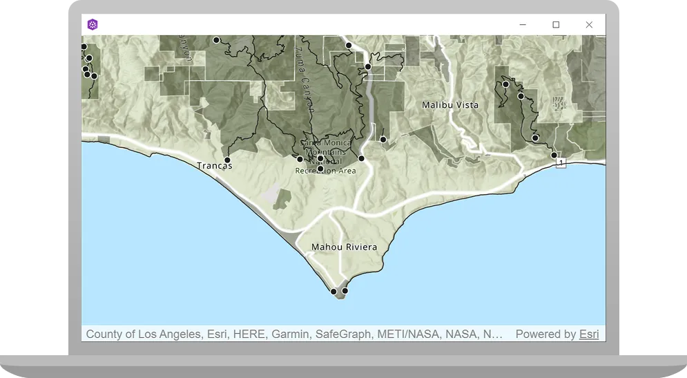
The map view should display all three feature layers in the map. Double-click, drag, and scroll the mouse wheel over the map view to explore the map.
Alternatively, you can download the tutorial solution, as follows.
Option 2: Download the solution
-
Click the
Download solutionlink underSolutionand unzip the file to a location on your machine. -
Open the .pro project file in Qt Creator.
Since the downloaded solution does not contain authentication credentials, you must set up authentication to create the developer credentials and add them to the project.
For the final steps of this tutorial, click the tab below that corresponds to the authentication type (API key authentication or User authentication) that you chose when you completed the Display a map tutorial.
Be sure to also provide the same authentication (API key or user authentication Client ID/Redirect URL) that you used for the Display a map tutorial.
Set developer credentials in the solution
Set the API Key
-
In the project Sources folder of Qt Creator, open the main.cpp file.
-
Modify the code to set the
accessTokenusing your API key access token (highlighted in yellow).main.cpp// The following methods grant an access token:// 1. User authentication: Grants a temporary access token associated with a user's ArcGIS account.// To generate a token, a user logs in to the app with an ArcGIS account that is part of an// organization in ArcGIS Online or ArcGIS Enterprise.// 2. API key authentication: Get a long-lived access token that gives your application access to// ArcGIS location services. Go to the tutorial at https://links.esri.com/create-an-api-key.// Copy the API Key access token.const QString accessToken = QString("");if (accessToken.isEmpty()){qWarning() << "Use of ArcGIS location services, such as the basemap styles service, requires" <<"you to authenticate with an ArcGIS account or set the API Key property.";}else{ArcGISRuntimeEnvironment::setApiKey(accessToken);} -
Save main.cpp file.
Best Practice: The access token is stored directly in the code as a convenience for this tutorial. Do not store credentials directly in source code in a production environment.
Set path to the Qt Toolkit in the project
In the project Sources folder of Qt Creator, open the Display_a_map.pro file and locate the following lines and update PATH_TO_TOOLKIT variable with the path of the toolkitcpp.pri file (highlighted in yellow) or the OAuth dialog will not appear to enter your user credentials. Then save the file.
ARCGIS_RUNTIME_VERSION = 300.0.0include($$PWD/arcgisruntime.pri)
# TODO: You need to replace the <path_to_toolkit_repo> with a valid location where the Qt Toolkit# resides on your system, example: C:/arcgis-maps-sdk-toolkit-qt/uitools/toolkitcpp/toolkitcpp.pri# This block determines whether you've cloned your toolkitPATH_TO_TOOLKIT = "<path_to_toolkit_repo>/uitools/toolkitcpp/toolkitcpp.pri"
exists($${PATH_TO_TOOLKIT}) {  message("Toolkit found")  DEFINES += TOOLKIT_FOUND
  # include the toolkitcpp.pri, which contains all the toolkit resources  include($${PATH_TO_TOOLKIT})
  qtHaveModule(webenginequick) {    QT += webenginequick  }} else {  message("Toolkit not found in provided path. Either set PATH_TO_TOOLKIT or use an API Key")}
Set developer credentials in the solution
-
In the project Sources folder of Qt Creator, open the Display_a_map.cpp file.
-
Set your values for the REDIRECT_URL and the CLIENT_ID strings (highlighted in yellow). Then save the file.
{
#ifdef TOOLKIT_FOUND
    // Define the Redirect URL string obtained when creating the OAuth credentials.    // TODO: You need to replace the "REDIRECT_URL" with your own valid string,    // ex: "urn:ietf:wg:oauth:2.0:oob"    const auto qStringRedirectUrl = QString{"REDIRECT_URL"};
    // Define the URL of the portal to authenticate with.    const QUrl qUrlPortal = QUrl{"https://www.arcgis.com/"};
    // Define a unique identifier associated with an application registered with the    // portal that assists with client/server OAuth authentication.    // TODO: You need to replace the "CLIENT_ID" with your own valid string.    const QString qStringClientId = QString{"CLIENT_ID"};
    // Create a new OAuth user configuration using: the Url to mapping web service, the Client ID    // string, and the Redirect Url string.    auto* oAuthUserConfiguration = new OAuthUserConfiguration(qUrlPortal, qStringClientId,                                                              qStringRedirectUrl, this);
    // Call the Toolkit's OAuthUserConfigurationManager static `addConfiguration`    // method to use the OAuth dialog. This will tell the Authenticator to use OAuth for the provided configuration.    Toolkit::OAuthUserConfigurationManager::addConfiguration(oAuthUserConfiguration);#endif // TOOLKIT_FOUND
Run the solution
Press Ctrl + R to run the app.
The map view should display all three feature layers in the map. Double-click, drag, and scroll the mouse wheel over the map view to explore the map.
What’s next?
Learn how to use additional API features, ArcGIS location services, and ArcGIS tools in these tutorials: