Display a layer from a WFS service, requesting only features for the current extent.
Use case
WFS is an open standard with functionality similar to ArcGIS feature services. ArcGIS Maps SDK support for WFS allows you to interoperate with open systems, which are often used in inter-agency efforts, like those for disaster relief.
How to use the sample
Pan and zoom the map to see features within the current map extent. The WFS layer will be populated with features for the visible area whenever you stop navigating the map.
How it works
- Create a
WfsFeatureTablewith a service URL and table name. - Set the feature request mode to
ManualCacheand axis order toNoSwap. - Create a
FeatureLayerfrom the WFS feature table and add it to the map's operational layers. - Listen for the
onVisibleAreaChangedevent to detect the visible map area, and for theonNavigationChangedevent to detect when the user has stopped navigating. - When navigation ends, call
populateFromService(...)on the WFS feature table, passing a query for the current visible extent. - Display a loading indicator while the WFS table is being populated.
Relevant API
- FeatureLayer
- MapView.onNavigationChanged
- MapView.onVisibleAreaChanged
- WfsFeatureTable
- WfsFeatureTable.populateFromService
About the data
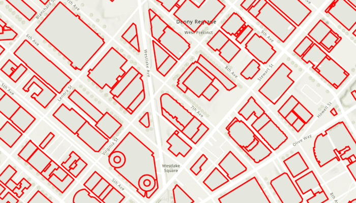
This sample uses a WFS service showing building footprints for downtown Seattle. For more information, see the ArcGIS Online item.
Tags
browse, catalog, feature, interaction cache, layers, OGC, service, web, WFS
Sample Code
/* Copyright 2025 Esri
*
* Licensed under the Apache License, Version 2.0 (the "License");
* you may not use this file except in compliance with the License.
* You may obtain a copy of the License at
*
* http://www.apache.org/licenses/LICENSE-2.0
*
* Unless required by applicable law or agreed to in writing, software
* distributed under the License is distributed on an "AS IS" BASIS,
* WITHOUT WARRANTIES OR CONDITIONS OF ANY KIND, either express or implied.
* See the License for the specific language governing permissions and
* limitations under the License.
*
*/
package com.esri.arcgismaps.sample.addwfslayer.components
import android.app.Application
import androidx.lifecycle.AndroidViewModel
import androidx.lifecycle.viewModelScope
import com.arcgismaps.Color
import com.arcgismaps.data.FeatureRequestMode
import com.arcgismaps.data.QueryParameters
import com.arcgismaps.data.SpatialRelationship.Intersects
import com.arcgismaps.data.WfsFeatureTable
import com.arcgismaps.geometry.Envelope
import com.arcgismaps.geometry.Polygon
import com.arcgismaps.geometry.SpatialReference
import com.arcgismaps.mapping.ArcGISMap
import com.arcgismaps.mapping.BasemapStyle
import com.arcgismaps.mapping.Viewpoint
import com.arcgismaps.mapping.layers.FeatureLayer
import com.arcgismaps.mapping.layers.OgcAxisOrder
import com.arcgismaps.mapping.symbology.SimpleLineSymbol
import com.arcgismaps.mapping.symbology.SimpleLineSymbolStyle
import com.arcgismaps.mapping.symbology.SimpleRenderer
import com.esri.arcgismaps.sample.sampleslib.components.MessageDialogViewModel
import kotlinx.coroutines.flow.MutableStateFlow
import kotlinx.coroutines.flow.StateFlow
import kotlinx.coroutines.flow.asStateFlow
import kotlinx.coroutines.launch
class AddWfsLayerViewModel(app: Application) : AndroidViewModel(app) {
// Message dialog for error reporting
val messageDialogVM = MessageDialogViewModel()
// WFS service URL and table name
private val wfsUrl = "https://dservices2.arcgis.com/ZQgQTuoyBrtmoGdP/arcgis/services/Seattle_Downtown_Features/WFSServer?service=wfs&request=getcapabilities"
private val wfsTableName = "Seattle_Downtown_Features:Buildings"
// Hold a reference to the WFS feature table for population
private val wfsFeatureTable = WfsFeatureTable(url = wfsUrl, tableName = wfsTableName).apply {
// Set manual cache mode so features are only requested when we call populateFromService
featureRequestMode = FeatureRequestMode.ManualCache
// Set axis order to NoSwap as required by the service
axisOrder = OgcAxisOrder.NoSwap
}
// The ArcGISMap with the Seattle downtown initial viewpoint
val arcGISMap = ArcGISMap(BasemapStyle.ArcGISTopographic).apply {
// Envelope for Seattle downtown area (used for initial viewpoint)
val seattleEnvelope = Envelope(
xMin = -122.341581, yMin = 47.613758, xMax = -122.332662, yMax = 47.617207,
spatialReference = SpatialReference.wgs84()
)
// FeatureLayer for displaying the WFS features
val wfsFeatureLayer = FeatureLayer.createWithFeatureTable(wfsFeatureTable).apply {
// Apply a simple red line renderer to building features
renderer = SimpleRenderer(
SimpleLineSymbol(
style = SimpleLineSymbolStyle.Solid,
color = Color.red,
width = 3f
)
)
}
initialViewpoint = Viewpoint(boundingGeometry = seattleEnvelope)
operationalLayers.add(wfsFeatureLayer)
}
// Track if the WFS table is currently populating
private val _isPopulating = MutableStateFlow(false)
val isPopulating: StateFlow<Boolean> = _isPopulating.asStateFlow()
// Used to track the latest visible area (Polygon)
private var visibleArea: Polygon? = null
init {
// The FeatureLayer is the only operational layer
val featureLayer = arcGISMap.operationalLayers.first() as FeatureLayer
// Load the map and layer
viewModelScope.launch {
arcGISMap.load().onFailure { messageDialogVM.showMessageDialog(it) }
featureLayer.load().onFailure { messageDialogVM.showMessageDialog(it) }
}
}
/**
* Called when the visible area changes. Used to update the visible area and trigger population if needed.
*/
fun onVisibleAreaChanged(polygon: Polygon) {
// Only populate on first visible area event
if (visibleArea == null) {
visibleArea = polygon
populateWfsLayer(polygon.extent)
} else {
visibleArea = polygon
}
}
/**
* Called when navigation ends. Populates the WFS table for the current visible extent.
*/
fun onNavigatingChanged(isNavigating: Boolean) {
if (!isNavigating) {
visibleArea?.extent?.let { populateWfsLayer(it) }
}
}
/**
* Populate the WFS feature table for the given extent.
*/
private fun populateWfsLayer(extent: Envelope) {
viewModelScope.launch {
_isPopulating.value = true
val query = QueryParameters().apply {
geometry = extent
spatialRelationship = Intersects
}
wfsFeatureTable.populateFromService(
parameters = query,
clearCache = false,
outFields = emptyList()
).onFailure {
messageDialogVM.showMessageDialog(it)
}
_isPopulating.value = false
}
}
}