Browse an OGC API feature service for layers and add them to the map.
Use case
OGC API standards are used for sharing geospatial data on the web. As an open standard, the OGC API aims to improve access to geospatial or location information and could be a good choice for sharing data internationally or between organizations. That data could be of any type, including, for example, transportation layers shared between government organizations and private businesses.
How to use the sample
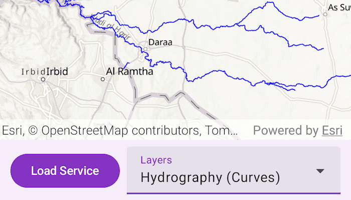
Select a layer to display from the list of layers shown in an OGC API service. The Daraa data is used as the default feature service, however, alternative feature services can be used.
How it works
- Create an
OgcFeatureServiceobject with a URL to an OGC API feature service. - Obtain the
OgcFeatureServiceInfofromOgcFeatureService.serviceInfo. - Create a list of feature collections from the
OgcFeatureServiceInfo.featureCollectionInfos. - When a feature collection is selected, create an
OgcFeatureCollectionTablefrom theOgcFeatureCollectionInfo. - Populate the
OgcFeatureCollectionTableusingpopulateFromService(...)withQueryParametersthat contain amaxFeaturesproperty. - Create a feature layer from the feature table.
- Add the feature layer to the map.
Relevant API
- OgcFeatureCollectionInfo
- OgcFeatureCollectionTable
- OgcFeatureService
- OgcFeatureServiceInfo
About the data
The Daraa, Syria test data is OpenStreetMap data converted to the Topographic Data Store schema of NGA.
Additional information
See the OGC API website for more information on the OGC API family of standards.
Tags
browse, catalog, feature, layers, OGC, OGC API, service, web
Sample Code
/* Copyright 2025 Esri
*
* Licensed under the Apache License, Version 2.0 (the "License");
* you may not use this file except in compliance with the License.
* You may obtain a copy of the License at
*
* http://www.apache.org/licenses/LICENSE-2.0
*
* Unless required by applicable law or agreed to in writing, software
* distributed under the License is distributed on an "AS IS" BASIS,
* WITHOUT WARRANTIES OR CONDITIONS OF ANY KIND, either express or implied.
* See the License for the specific language governing permissions and
* limitations under the License.
*
*/
package com.esri.arcgismaps.sample.browseogcapifeatureservice.components
import android.app.Application
import androidx.compose.runtime.getValue
import androidx.compose.runtime.mutableStateOf
import androidx.compose.runtime.setValue
import androidx.lifecycle.AndroidViewModel
import androidx.lifecycle.viewModelScope
import com.arcgismaps.Color
import com.arcgismaps.data.FeatureRequestMode
import com.arcgismaps.data.OgcFeatureCollectionTable
import com.arcgismaps.data.QueryParameters
import com.arcgismaps.geometry.GeometryType
import com.arcgismaps.geometry.Point
import com.arcgismaps.geometry.SpatialReference
import com.arcgismaps.mapping.ArcGISMap
import com.arcgismaps.mapping.BasemapStyle
import com.arcgismaps.mapping.Viewpoint
import com.arcgismaps.mapping.layers.FeatureLayer
import com.arcgismaps.mapping.layers.OgcFeatureCollectionInfo
import com.arcgismaps.mapping.layers.OgcFeatureService
import com.arcgismaps.mapping.symbology.SimpleFillSymbol
import com.arcgismaps.mapping.symbology.SimpleFillSymbolStyle
import com.arcgismaps.mapping.symbology.SimpleLineSymbol
import com.arcgismaps.mapping.symbology.SimpleLineSymbolStyle
import com.arcgismaps.mapping.symbology.SimpleMarkerSymbol
import com.arcgismaps.mapping.symbology.SimpleMarkerSymbolStyle
import com.arcgismaps.mapping.symbology.SimpleRenderer
import com.arcgismaps.toolkit.geoviewcompose.MapViewProxy
import com.esri.arcgismaps.sample.sampleslib.components.MessageDialogViewModel
import kotlinx.coroutines.flow.MutableStateFlow
import kotlinx.coroutines.flow.StateFlow
import kotlinx.coroutines.flow.asStateFlow
import kotlinx.coroutines.launch
class BrowseOgcApiFeatureServiceViewModel(app: Application) : AndroidViewModel(app) {
val mapViewProxy = MapViewProxy()
// Message dialog for error handling
val messageDialogVM = MessageDialogViewModel()
var arcGISMap = ArcGISMap(BasemapStyle.ArcGISTopographic).apply {
initialViewpoint = Viewpoint(
center = Point(x = 36.10, y = 32.62, spatialReference = SpatialReference.wgs84()),
scale = 200000.0
)
}
// The current OGC API feature service URL
var ogcServiceUrl by mutableStateOf("https://demo.ldproxy.net/daraa")
private set
// The list of available feature collection info titles
private val _featureCollectionTitles = MutableStateFlow<List<String>>(emptyList())
val featureCollectionTitles: StateFlow<List<String>> = _featureCollectionTitles.asStateFlow()
// Map of title to OgcFeatureCollectionInfo
private val featureCollectionInfos = mutableMapOf<String, OgcFeatureCollectionInfo>()
// The currently selected feature collection title
var selectedTitle by mutableStateOf("")
private set
// Show/hide the input dialog for entering a new OGC API URL
var isUrlDialogVisible by mutableStateOf(false)
private set
// The text input for the OGC API URL dialog
var urlInputText by mutableStateOf("https://demo.ldproxy.net/daraa")
private set
// The OGC API feature service instance
private var ogcFeatureService: OgcFeatureService? = null
/**
* Loads an OGC API feature service from the given [url].
*/
fun loadOgcFeatureService(url: String) {
viewModelScope.launch {
ogcFeatureService = OgcFeatureService(url)
ogcFeatureService?.load()?.onSuccess {
val serviceInfo = ogcFeatureService?.serviceInfo
val infos = serviceInfo?.featureCollectionInfos ?: emptyList()
// Map titles to info objects, discarding duplicates
featureCollectionInfos.clear()
infos.forEach { info ->
if (!featureCollectionInfos.containsKey(info.title)) {
featureCollectionInfos[info.title] = info
}
}
_featureCollectionTitles.value = featureCollectionInfos.keys.toList()
// Set the selected title to the first available
selectedTitle = featureCollectionTitles.value.firstOrNull() ?: ""
// Display the first layer if available
selectedTitle.takeIf { it.isNotEmpty() }?.let { title ->
displayLayerForTitle(title)
}
}?.onFailure {
messageDialogVM.showMessageDialog(
title = "Failed to load OGC API feature service",
description = it.message.toString()
)
}
}
}
/**
* Loads and displays the feature layer for the given feature collection [title].
*/
private fun displayLayerForTitle(title: String) {
val info = featureCollectionInfos[title] ?: return
viewModelScope.launch {
// Remove all operational layers
arcGISMap.operationalLayers.clear()
// Create the OGC feature collection table
val ogcFeatureCollectionTable = OgcFeatureCollectionTable(info)
ogcFeatureCollectionTable.featureRequestMode = FeatureRequestMode.ManualCache
// Populate the table with up to 1000 features
val queryParams = QueryParameters().apply { maxFeatures = 1000 }
ogcFeatureCollectionTable.populateFromService(queryParams, clearCache = false).onSuccess {
// Create the feature layer
val featureLayer = FeatureLayer.createWithFeatureTable(ogcFeatureCollectionTable)
// Set a renderer based on geometry type
featureLayer.renderer = createRendererForGeometryType(ogcFeatureCollectionTable.geometryType)
arcGISMap.operationalLayers.add(featureLayer)
info.extent?.let { envelope ->
mapViewProxy.setViewpointAnimated(Viewpoint(boundingGeometry = envelope))
}
}.onFailure {
messageDialogVM.showMessageDialog(
title = "Failed to populate OGC feature collection table",
description = it.message.toString()
)
}
}
}
/**
* Creates a SimpleRenderer with a symbol appropriate for the given [geometryType].
*/
private fun createRendererForGeometryType(geometryType: GeometryType?): SimpleRenderer? {
return when (geometryType) {
GeometryType.Point, GeometryType.Multipoint -> SimpleRenderer(
SimpleMarkerSymbol(
style = SimpleMarkerSymbolStyle.Circle,
color = Color.blue,
size = 5f
)
)
GeometryType.Polyline -> SimpleRenderer(
SimpleLineSymbol(
style = SimpleLineSymbolStyle.Solid,
color = Color.blue,
width = 1f
)
)
GeometryType.Polygon, GeometryType.Envelope -> SimpleRenderer(
SimpleFillSymbol(
style = SimpleFillSymbolStyle.Solid,
color = Color.blue
)
)
else -> null
}
}
/**
* Called when the user selects a new feature collection title.
*/
fun onFeatureCollectionTitleSelected(title: String) {
selectedTitle = title
displayLayerForTitle(title)
}
/**
* Called when the user requests to open the OGC API URL dialog.
*/
fun onOpenUrlDialog() {
isUrlDialogVisible = true
urlInputText = ogcServiceUrl
}
/**
* Called when the user cancels the OGC API URL dialog.
*/
fun onCancelUrlDialog() {
isUrlDialogVisible = false
urlInputText = ogcServiceUrl
}
/**
* Called when the user confirms a new OGC API URL.
*/
fun onConfirmUrlDialog() {
isUrlDialogVisible = false
ogcServiceUrl = urlInputText
loadOgcFeatureService(ogcServiceUrl)
}
/**
* Called when the user edits the OGC API URL input text.
*/
fun onUrlInputTextChanged(newText: String) {
urlInputText = newText
}
}
// Extension property to provide blue color for ArcGISMaps Color class
val Color.Companion.blue: Color
get() = fromRgba(0, 0, 255, 255)