Format coordinates in a variety of common notations.
Use case
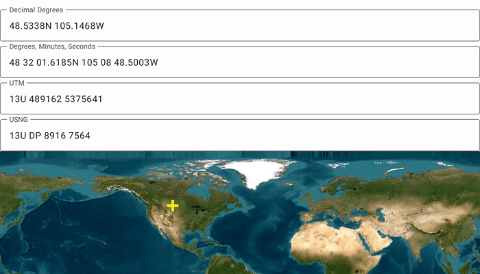
The coordinate formatter can format a map location in WGS84 in a number of common coordinate notations. Parsing one of these formats to a location is also supported. Formats include decimal degrees; degrees, minutes, seconds; Universal Transverse Mercator (UTM), and United States National Grid (USNG).
How to use the sample
Tap on the map to see a marker with the tapped location's coordinate formatted in 4 different ways. You can also put a coordinate string in any of these formats in the text field. Hit Enter and the coordinate string will be parsed to a map location which the marker will move to.
How it works
- Get or create a map
Pointwith a spatial reference. - Use one of the static "to" methods on
CoordinateFormattersuch asCoordinateFormatter.toLatitudeLongitudeOrNull(point = newLocation, format = LatitudeLongitudeFormat.DecimalDegrees, decimalPlaces = 4)to get the formatted string. - To go from a formatted string to a
Point, use one of the "from" static methods likeCoordinateFormatter.fromUtmOrNull(coordinates = coordinateNotation, utmConversionMode = UtmConversionMode.LatitudeBandIndicators, spatialReference = null).
Relevant API
- CoordinateFormatter
- CoordinateFormatter.LatitudeLongitudeFormat
- CoordinateFormatter.UtmConversionMode
Additional information
This sample uses the GeoView-Compose Toolkit module to be able to implement a composable MapView.
Tags
convert, coordinate, decimal degrees, degree minutes seconds, format, geoview-compose, latitude, longitude, toolkit, USNG, UTM
Sample Code
/* Copyright 2023 Esri
*
* Licensed under the Apache License, Version 2.0 (the "License");
* you may not use this file except in compliance with the License.
* You may obtain a copy of the License at
*
* http://www.apache.org/licenses/LICENSE-2.0
*
* Unless required by applicable law or agreed to in writing, software
* distributed under the License is distributed on an "AS IS" BASIS,
* WITHOUT WARRANTIES OR CONDITIONS OF ANY KIND, either express or implied.
* See the License for the specific language governing permissions and
* limitations under the License.
*
*/
package com.esri.arcgismaps.sample.showcoordinatesinmultipleformats.components
import android.app.Application
import androidx.compose.runtime.getValue
import androidx.compose.runtime.mutableStateOf
import androidx.compose.runtime.setValue
import androidx.lifecycle.AndroidViewModel
import com.arcgismaps.Color
import com.arcgismaps.geometry.CoordinateFormatter
import com.arcgismaps.geometry.LatitudeLongitudeFormat
import com.arcgismaps.geometry.Point
import com.arcgismaps.geometry.SpatialReference
import com.arcgismaps.geometry.UtmConversionMode
import com.arcgismaps.mapping.symbology.SimpleMarkerSymbol
import com.arcgismaps.mapping.symbology.SimpleMarkerSymbolStyle
import com.arcgismaps.mapping.view.Graphic
import com.esri.arcgismaps.sample.sampleslib.components.MessageDialogViewModel
class MapViewModel(application: Application) : AndroidViewModel(application) {
var decimalDegrees by mutableStateOf("")
private set
var degreesMinutesSeconds by mutableStateOf("")
private set
var utm by mutableStateOf("")
private set
var usng by mutableStateOf("")
private set
// create a ViewModel to handle dialog interactions
val messageDialogVM: MessageDialogViewModel = MessageDialogViewModel()
// set up a graphic to indicate where the coordinates relate to, with an initial location
val initialPoint = Point(0.0, 0.0, SpatialReference.wgs84())
val coordinateLocationGraphic = Graphic(
geometry = initialPoint,
symbol = SimpleMarkerSymbol(
style = SimpleMarkerSymbolStyle.Cross,
color = Color.fromRgba(255, 255, 0, 255),
size = 20f
)
)
/**
* Uses CoordinateFormatter to update the UI with coordinate notation strings based on the
* given [newLocation] point to convert to coordinate notations
*/
fun toCoordinateNotationFromPoint(newLocation: Point) {
coordinateLocationGraphic.geometry = newLocation
// use CoordinateFormatter to convert to Latitude Longitude, formatted as Decimal Degrees
decimalDegrees = CoordinateFormatter.toLatitudeLongitudeOrNull(
point = newLocation,
format = LatitudeLongitudeFormat.DecimalDegrees,
decimalPlaces = 4
) ?: return messageDialogVM.showMessageDialog("Failed to convert from point DD coordinate")
// use CoordinateFormatter to convert to Latitude Longitude, formatted as Degrees, Minutes, Seconds
degreesMinutesSeconds = CoordinateFormatter.toLatitudeLongitudeOrNull(
point = newLocation,
format = LatitudeLongitudeFormat.DegreesMinutesSeconds,
decimalPlaces = 4
) ?: return messageDialogVM.showMessageDialog("Failed to convert from point DMS coordinate")
// use CoordinateFormatter to convert to Universal Transverse Mercator, using latitudinal bands indicator
utm = CoordinateFormatter.toUtmOrNull(
point = newLocation,
utmConversionMode = UtmConversionMode.LatitudeBandIndicators,
addSpaces = true
) ?: return messageDialogVM.showMessageDialog("Failed to convert from point UTM coordinate")
// use CoordinateFormatter to convert to United States National Grid (USNG)
usng = CoordinateFormatter.toUsngOrNull(
point = newLocation,
precision = 4,
addSpaces = true,
) ?: return messageDialogVM.showMessageDialog("Failed to convert from point USNG coordinate")
}
/**
* Uses CoordinateFormatter to update the graphic in the map from the given [coordinateNotation]
* string entered by the user. Also calls corresponding method to update all the remaining
* [coordinateNotation] strings using the notation [notationType].
*/
fun fromCoordinateNotationToPoint(notationType: NotationType, coordinateNotation: String) {
// ignore empty input coordinate notation strings, do not update UI
if (coordinateNotation.isEmpty()) return
val convertedPoint: Point = when (notationType) {
NotationType.DMS, NotationType.DD -> {
// use CoordinateFormatter to parse Latitude Longitude - different numeric notations (Decimal Degrees;
// Degrees, Minutes, Seconds; Degrees, Decimal Minutes) can all be passed to this same method
CoordinateFormatter.fromLatitudeLongitudeOrNull(
coordinates = coordinateNotation,
spatialReference = null
) ?: return messageDialogVM.showMessageDialog("Failed to convert DMS/DD coordinate to point")
}
NotationType.UTM -> {
// use CoordinateFormatter to parse UTM coordinates
CoordinateFormatter.fromUtmOrNull(
coordinates = coordinateNotation,
utmConversionMode = UtmConversionMode.LatitudeBandIndicators,
spatialReference = null
) ?: return messageDialogVM.showMessageDialog("Failed to convert UTM coordinate to point")
}
NotationType.USNG -> {
// use CoordinateFormatter to parse US National Grid coordinates
CoordinateFormatter.fromUsngOrNull(
coordinates = coordinateNotation,
spatialReference = null
) ?: return messageDialogVM.showMessageDialog("Failed to convert USNG coordinate to point")
}
}
// update the location shown in the map
toCoordinateNotationFromPoint(convertedPoint)
}
/**
* Coordinate notations supported by this sample
*/
enum class NotationType {
DMS, DD, UTM, USNG
}
/**
* Set's [decimalDegrees] entered in the text field to the [inputString]
*/
fun setDecimalDegreesCoordinate(inputString: String) {
decimalDegrees = inputString
}
/**
* Set's [degreesMinutesSeconds] entered in the text field to the [inputString]
*/
fun degreesMinutesSecondsCoordinate(inputString: String) {
degreesMinutesSeconds = inputString
}
/**
* Set's [utm] entered in the text field to the [inputString]
*/
fun setUTMCoordinate(inputString: String) {
utm = inputString
}
/**
* Set's [usng] entered in the text field to the [inputString]
*/
fun setUSNGDegreesCoordinate(inputString: String) {
usng = inputString
}
}