Apply mosaic rule to a mosaic dataset of rasters.
Use case
An image service can use a mosaic rule to mosaic multiple rasters on-the-fly. A mosaic rule can specify which rasters are selected, and how the selected rasters are z-ordered. It can also specify how overlapping pixels from different rasters at the same location are resolved.
For example, when using the “By Attribute” mosaic method, the values in an attribute field are used to sort the images, and when using the “Center” method, the image closest to the center of the display is positioned as the top image in the mosaic. Additionally, the mosaic operator allows you to define how to resolve the overlapping cells, such as choosing a blending operation.
Specifying mosaic rules is useful for viewing overlapping rasters. For example, using the “ByAttribute” mosaic method to sort the rasters based on their acquisition date allows the newest image to be on top. Using “mean” mosaic operation makes the overlapping areas contain the mean cell values from all the overlapping rasters.
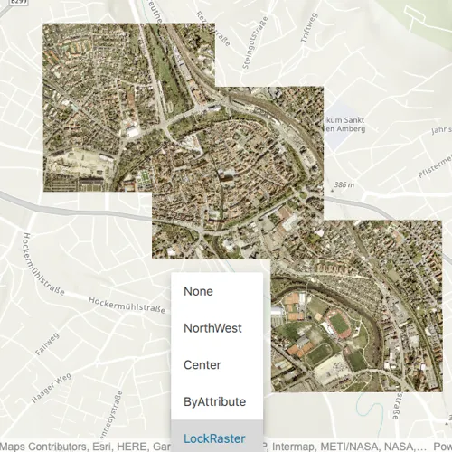
How to use the sample
When the rasters are loaded, choose from a list of preset mosaic rules to apply to the rasters.
How it works
- Create an
ImageServiceRasterusing the service’s URL. - Create a
RasterLayerfrom the image service raster and add it to the map. - Create a
MosaicRuleobject and set it to themosaicRuleproperty of the image service raster. - Use
MosaicRule::setMosaicMethod,MosaicRule::setMosaicOperationand other functions of the mosaic rule object accordingly to specify the rule on the raster dataset.
Relevant API
- ImageServiceRaster
- MosaicRule
- MosaicRule::setMosaicMethod
- MosaicRule::setMosaicOperation
About the data
This sample uses a raster image service hosted on ArcGIS Online that shows aerial images of Amberg, Germany.
Additional information
For more information, see Understanding the mosaicking rules from ArcGIS Desktop documentation. To learn more about how to define certain mosaic rules, see Mosaic rule objects from ArcGIS for Developers.
Tags
image service, mosaic method, mosaic rule, raster
Sample code
// [WriteFile Name=ApplyMosaicRuleToRasters, Category=Layers]// [Legal]// Copyright 2020 Esri.//// Licensed under the Apache License, Version 2.0 (the "License");// you may not use this file except in compliance with the License.// You may obtain a copy of the License at// http://www.apache.org/licenses/LICENSE-2.0//// Unless required by applicable law or agreed to in writing, software// distributed under the License is distributed on an "AS IS" BASIS,// WITHOUT WARRANTIES OR CONDITIONS OF ANY KIND, either express or implied.// See the License for the specific language governing permissions and// limitations under the License.// [Legal]
#ifdef PCH_BUILD#include "pch.hpp"#endif // PCH_BUILD
// sample headers#include "ApplyMosaicRuleToRasters.h"
// ArcGIS Maps SDK headers#include "Envelope.h"#include "Error.h"#include "ImageServiceRaster.h"#include "LayerListModel.h"#include "Map.h"#include "MapQuickView.h"#include "MapTypes.h"#include "MosaicRule.h"#include "Point.h"#include "RasterLayer.h"#include "RasterTypes.h"
// Qt headers#include <QFuture>
using namespace Esri::ArcGISRuntime;
ApplyMosaicRuleToRasters::ApplyMosaicRuleToRasters(QObject* parent /* = nullptr */):  QObject(parent),  m_map(new Map(BasemapStyle::ArcGISTopographic, this)),  m_mosaicRule(new MosaicRule(this)){}
ApplyMosaicRuleToRasters::~ApplyMosaicRuleToRasters() = default;
void ApplyMosaicRuleToRasters::init(){  // Register the map view for QML  qmlRegisterType<MapQuickView>("Esri.Samples", 1, 0, "MapView");  qmlRegisterType<ApplyMosaicRuleToRasters>("Esri.Samples", 1, 0, "ApplyMosaicRuleToRastersSample");}
MapQuickView* ApplyMosaicRuleToRasters::mapView() const{  return m_mapView;}
// Set the view (created in QML)void ApplyMosaicRuleToRasters::setMapView(MapQuickView* mapView){  if (!mapView || mapView == m_mapView)    return;
  m_mapView = mapView;  m_mapView->setMap(m_map);
  // Create image service raster from image server  m_imageServiceRaster = new ImageServiceRaster(QUrl("https://sampleserver7.arcgisonline.com/server/rest/services/amberg_germany/ImageServer"), this);
  // Set Mosaic Rule if none exists on the image service raster  if (!m_imageServiceRaster->mosaicRule())    m_imageServiceRaster->setMosaicRule(m_mosaicRule);
  // Create a raster layer form the image service raster  m_rasterLayer = new RasterLayer(m_imageServiceRaster, this);
  // Once loaded change the viewpoint the the center of the raster layers full extent  connect(m_rasterLayer, &RasterLayer::doneLoading, this, [this](const Error& e)  {    if (e.isEmpty())    {      m_rasterLoaded = true;      emit rasterLoadedChanged();      m_mapView->setViewpointCenterAsync(m_rasterLayer->fullExtent().center(), 25000.0);    }  });
  m_map->operationalLayers()->append(m_rasterLayer);  emit mapViewChanged();}
void ApplyMosaicRuleToRasters::applyRasterRule(const QString& ruleString){  // Reset to clear previous mosaic rule parameters  ApplyMosaicRuleToRasters::resetMosaicRule();
  if (ruleString == "None")  {    m_mosaicRule->setMosaicMethod(MosaicMethod::None);  }  else if (ruleString == "NorthWest")  {    m_mosaicRule->setMosaicMethod(MosaicMethod::Northwest);    m_mosaicRule->setMosaicOperation(MosaicOperation::First);  }  else if (ruleString == "Center")  {    m_mosaicRule->setMosaicMethod(MosaicMethod::Center);    m_mosaicRule->setMosaicOperation(MosaicOperation::Blend);  }  else if (ruleString == "ByAttribute")  {    m_mosaicRule->setMosaicMethod(MosaicMethod::Attribute);    m_mosaicRule->setSortField("OBJECTID");
  }  else if (ruleString  == "LockRaster")  {    m_mosaicRule->setMosaicMethod(MosaicMethod::LockRaster);    m_mosaicRule->setLockRasterIds(QList<qint64>{1,7,12});  }  m_imageServiceRaster->setMosaicRule(m_mosaicRule);}
// Helper function to reset the mosaic rulevoid ApplyMosaicRuleToRasters::resetMosaicRule(){  delete m_mosaicRule;  m_mosaicRule = new MosaicRule(this);}
// [WriteFile Name=ApplyMosaicRuleToRasters, Category=Layers]// [Legal]// Copyright 2020 Esri.//// Licensed under the Apache License, Version 2.0 (the "License");// you may not use this file except in compliance with the License.// You may obtain a copy of the License at// http://www.apache.org/licenses/LICENSE-2.0//// Unless required by applicable law or agreed to in writing, software// distributed under the License is distributed on an "AS IS" BASIS,// WITHOUT WARRANTIES OR CONDITIONS OF ANY KIND, either express or implied.// See the License for the specific language governing permissions and// limitations under the License.// [Legal]
#ifndef APPLYMOSAICRULETORASTERS_H#define APPLYMOSAICRULETORASTERS_H
// Qt headers#include <QObject>
namespace Esri::ArcGISRuntime{class ImageServiceRaster;class Map;class MapQuickView;class MosaicRule;class RasterLayer;}
Q_MOC_INCLUDE("MapQuickView.h")
class ApplyMosaicRuleToRasters : public QObject{ Q_OBJECT
Q_PROPERTY(Esri::ArcGISRuntime::MapQuickView* mapView READ mapView WRITE setMapView NOTIFY mapViewChanged) Q_PROPERTY(bool rasterLoaded MEMBER m_rasterLoaded NOTIFY rasterLoadedChanged)
public: explicit ApplyMosaicRuleToRasters(QObject* parent = nullptr); ~ApplyMosaicRuleToRasters();
static void init(); Q_INVOKABLE void applyRasterRule(const QString& ruleString);
signals: void mapViewChanged(); void rasterLoadedChanged();
private: Esri::ArcGISRuntime::MapQuickView* mapView() const; void setMapView(Esri::ArcGISRuntime::MapQuickView* mapView);
void resetMosaicRule();
Esri::ArcGISRuntime::Map* m_map = nullptr; Esri::ArcGISRuntime::MapQuickView* m_mapView = nullptr; Esri::ArcGISRuntime::ImageServiceRaster* m_imageServiceRaster = nullptr; Esri::ArcGISRuntime::RasterLayer* m_rasterLayer = nullptr; Esri::ArcGISRuntime::MosaicRule* m_mosaicRule = nullptr; bool m_rasterLoaded = false;
};
#endif // APPLYMOSAICRULETORASTERS_H// [WriteFile Name=ApplyMosaicRuleToRasters, Category=Layers]// [Legal]// Copyright 2020 Esri.//// Licensed under the Apache License, Version 2.0 (the "License");// you may not use this file except in compliance with the License.// You may obtain a copy of the License at// http://www.apache.org/licenses/LICENSE-2.0//// Unless required by applicable law or agreed to in writing, software// distributed under the License is distributed on an "AS IS" BASIS,// WITHOUT WARRANTIES OR CONDITIONS OF ANY KIND, either express or implied.// See the License for the specific language governing permissions and// limitations under the License.// [Legal]
import QtQuickimport QtQuick.Controlsimport Esri.Samples
Item {
property var rasterRules: ["None","NorthWest","Center","ByAttribute","LockRaster"]
// add a mapView component MapView { id: view anchors.fill: parent
Component.onCompleted: { // Set the focus on MapView to initially enable keyboard navigation forceActiveFocus(); }
Rectangle { width: childrenRect.width height: childrenRect.height anchors { bottom: view.attributionTop horizontalCenter: view.horizontalCenter } color: "lightgrey" opacity: 0.8 visible: model.rasterLoaded
Column { Text { anchors.horizontalCenter: parent.horizontalCenter text: qsTr("Select Mosaic Rule") } ComboBox { id: rasterRulesComboBox anchors.horizontalCenter: parent.horizontalCenter model: rasterRules visible: model.rasterLoaded
onActivated: model.applyRasterRule(rasterRules[currentIndex]); } } } }
// Declare the C++ instance which creates the map etc. and supply the view ApplyMosaicRuleToRastersSample { id: model mapView: view }}