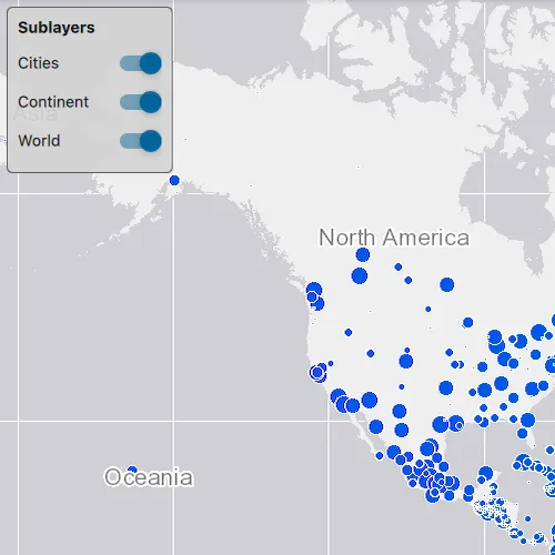
Change the visibility of sublayers.
Use case
A map image layer may contain many sublayers such as different types of roads in a road network or city, county, and state borders in a US map. The user may only be interested in a subset of these sublayers. Or, perhaps showing all of the sublayers would show too much detail. In these cases, you can hide certain sublayers by changing their visibility.
How to use the sample
Each sublayer has a check box which can be used to toggle the visibility of the sublayer.
How it works
- Create an
ArcGISMapImageLayerobject with the URL to a map image service. - Get the
ArcGISSublayerListModelwithmapImageLayer::mapImageSublayers(). - For each layer in the sublayer list, set its visible property to true or false.
Relevant API
- ArcGISMapImageLayer
- ArcGISSublayerListModel
Tags
layer, sublayer, visibility
Sample code
// [WriteFile Name=ChangeSublayerVisibility, Category=Layers]// [Legal]// Copyright 2016 Esri.//// Licensed under the Apache License, Version 2.0 (the "License");// you may not use this file except in compliance with the License.// You may obtain a copy of the License at// http://www.apache.org/licenses/LICENSE-2.0//// Unless required by applicable law or agreed to in writing, software// distributed under the License is distributed on an "AS IS" BASIS,// WITHOUT WARRANTIES OR CONDITIONS OF ANY KIND, either express or implied.// See the License for the specific language governing permissions and// limitations under the License.// [Legal]
#ifdef PCH_BUILD#include "pch.hpp"#endif // PCH_BUILD
// sample headers#include "ChangeSublayerVisibility.h"
// ArcGIS Maps SDK headers#include "ArcGISMapImageLayer.h"#include "ArcGISSublayerListModel.h"#include "Basemap.h"#include "LayerListModel.h"#include "Map.h"#include "MapQuickView.h"#include "MapTypes.h"#include "Point.h"#include "SpatialReference.h"#include "Viewpoint.h"
// Qt headers#include <QUrl>
using namespace Esri::ArcGISRuntime;
ChangeSublayerVisibility::ChangeSublayerVisibility(QQuickItem* parent) :  QQuickItem(parent){}
ChangeSublayerVisibility::~ChangeSublayerVisibility() = default;
void ChangeSublayerVisibility::init(){  qmlRegisterType<MapQuickView>("Esri.Samples", 1, 0, "MapView");  qmlRegisterType<ChangeSublayerVisibility>("Esri.Samples", 1, 0, "ChangeSublayerVisibilitySample");  qmlRegisterUncreatableType<QAbstractListModel>("Esri.Samples", 1, 0, "AbstractListModel", "AbstractListModel is uncreateable");}
void ChangeSublayerVisibility::componentComplete(){  QQuickItem::componentComplete();
  // find QML MapView component  m_mapView = findChild<MapQuickView*>("mapView");
  // create a new map instance  m_map = new Map(BasemapStyle::ArcGISTopographic, this);  m_map->setInitialViewpoint(Viewpoint(Point(-11e6, 6e6, SpatialReference(102100)), 9e7));
  // add the map image layer  m_mapImageLayer = new ArcGISMapImageLayer(QUrl("https://sampleserver6.arcgisonline.com/arcgis/rest/services/SampleWorldCities/MapServer"), this);  m_map->operationalLayers()->append(m_mapImageLayer);
  // set map on the map view  m_mapView->setMap(m_map);
  // set the map image layer's sublayer list model to the Q_PROPERTY  m_sublayerModel = m_mapImageLayer->mapImageSublayers();  emit sublayerModelChanged();}
QAbstractListModel* ChangeSublayerVisibility::sublayerModel(){  return m_sublayerModel;}
// [WriteFile Name=ChangeSublayerVisibility, Category=Layers]// [Legal]// Copyright 2016 Esri.//// Licensed under the Apache License, Version 2.0 (the "License");// you may not use this file except in compliance with the License.// You may obtain a copy of the License at// http://www.apache.org/licenses/LICENSE-2.0//// Unless required by applicable law or agreed to in writing, software// distributed under the License is distributed on an "AS IS" BASIS,// WITHOUT WARRANTIES OR CONDITIONS OF ANY KIND, either express or implied.// See the License for the specific language governing permissions and// limitations under the License.// [Legal]
#ifndef CHANGE_SUBLAYER_VISIBILITY_H#define CHANGE_SUBLAYER_VISIBILITY_H
// Qt headers#include <QAbstractListModel>#include <QQuickItem>
namespace Esri::ArcGISRuntime{ class Map; class MapQuickView; class ArcGISMapImageLayer;}
class ChangeSublayerVisibility : public QQuickItem{ Q_OBJECT
Q_PROPERTY(QAbstractListModel* sublayerModel READ sublayerModel NOTIFY sublayerModelChanged)
public: explicit ChangeSublayerVisibility(QQuickItem* parent = nullptr); ~ChangeSublayerVisibility() override;
void componentComplete() override; static void init();
signals: void sublayerModelChanged();
private: QAbstractListModel* sublayerModel();
private: Esri::ArcGISRuntime::Map* m_map = nullptr; Esri::ArcGISRuntime::MapQuickView* m_mapView = nullptr; Esri::ArcGISRuntime::ArcGISMapImageLayer* m_mapImageLayer = nullptr; QAbstractListModel* m_sublayerModel = nullptr;};
#endif // CHANGE_SUBLAYER_VISIBILITY_H// [WriteFile Name=ChangeSublayerVisibility, Category=Layers]// [Legal]// Copyright 2016 Esri.//// Licensed under the Apache License, Version 2.0 (the "License");// you may not use this file except in compliance with the License.// You may obtain a copy of the License at// http://www.apache.org/licenses/LICENSE-2.0//// Unless required by applicable law or agreed to in writing, software// distributed under the License is distributed on an "AS IS" BASIS,// WITHOUT WARRANTIES OR CONDITIONS OF ANY KIND, either express or implied.// See the License for the specific language governing permissions and// limitations under the License.// [Legal]
import QtQuickimport QtQuick.Controlsimport Esri.Samples
ChangeSublayerVisibilitySample { id: changeSublayerVisibilitySample width: 800 height: 600
// add a mapView component MapView { anchors.fill: parent objectName: "mapView"
Component.onCompleted: { // Set the focus on MapView to initially enable keyboard navigation forceActiveFocus(); } }
// Create a window to display the sublayers Rectangle { id: layerVisibilityRect anchors { margins: 10 left: parent.left top: parent.top } height: 150 width: 170 color: "transparent"
MouseArea { anchors.fill: parent onClicked: mouse => mouse.accepted = true onWheel: wheel => wheel.accepted = true }
Rectangle { anchors.fill: parent width: layerVisibilityRect.width height: layerVisibilityRect.height color: "lightgrey" opacity: .9 radius: 5 border { color: "#4D4D4D" width: 1 }
Column { anchors { fill: parent margins: 10 }
Text { width: parent.width text: "Sublayers" wrapMode: Text.WordWrap clip: true font { pointSize: 14 bold: true } }
// Create a list view to display the items ListView { id: layerVisibilityListView anchors.margins: 10 width: parent.width height: parent.height clip: true
// Assign the model to the list model of sublayers model: changeSublayerVisibilitySample.sublayerModel
// Assign the delegate to the delegate created above delegate: Item { id: layerVisibilityDelegate width: parent.width height: 35
Row { spacing: 5 Text { anchors.verticalCenter: parent.verticalCenter width: 75 text: name wrapMode: Text.WordWrap font.pointSize: 14 }
Switch { anchors.verticalCenter: parent.verticalCenter checked: sublayerVisible
onCheckedChanged: { sublayerVisible = checked; } } } } } } } }}