September 2021
Performance improvements
Version 4.21 introduces many performance improvements that will decrease the draw time of your layers. These improvements are focused on polygon features and maps with multiple layers.
Complex polygons
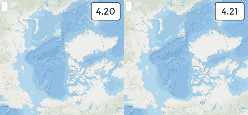
For complex polygons with a large number of vertices, layer draw time has significantly improved. Behind the scenes, we added a new simplification algorithm to preprocess the geometries and optimize memory management. We now use web assembly for triangulation for the majority of use cases. As you can see in the example below, this Arctic sea ice layer loads over 5x faster than the same layer in 4.20. The improvement varies layer by layer, but for most polygons with a large number of vertices, you will see at least a 2-3x improvement.
Large layers with many polygons
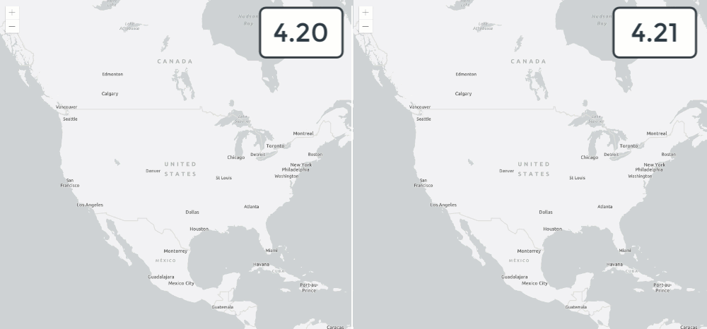
Because of the optimizations mentioned above and the switch to web assembly, you should also see performance improvements for layers with a large number of polygon features. The following example shows a layer with over 73,000 polygons. On average, we are seeing a 20% improvement in draw time.
Maps with many layers
We've also added some optimizations for the way we handle maps with a large number of feature collections. These optimizations have resulted in an improved start time and an improved frame rate for smoother map panning.
Enterprise point FeatureLayers
At version 4.19, we improved the performance of point FeatureLayers hosted on ArcGIS Online. Version 4.21 brings these changes to ArcGIS Enterprise point services.
Control the drawing order of features
You can configure the order features are drawn in the view by setting the order property of a FeatureLayer, CSVLayer, GeoJSONLayer, and OGCFeatureLayer.
This property allows you to sort features using any field or Arcade expression that returns a number or a date.
layer.orderBy = [{
order: "descending", // or "ascending"
field: "Population",
// or alternatively...
valueExpression: "$feature.Poverty / $feature.Population"
}];In layers with date fields that have many overlapping features, this property allows you to ensure the most recent features are drawn on top of older ones. This property is also important in proportional symbol maps where smaller features are typically rendered on top of large ones to maximize the visibility of overlapping features in the view.
| ascending (small values on top) | descending (large values on top) |
|---|---|

|

|
Check out the Configure feature sort order sample for more information.
Layer updates
Refreshable layers
We've added the following optimizations and improvements for working with refreshable layers — layers that update their data at a specified interval. A layer is refreshable if it has a refresh property.
- To reduce load on the server and minimize unnecessary requests, the FeatureLayer will only request data at its specified refreshInterval if the
lastin the layer's metadata has changed. If the FeatureLayer does not haveEdit Date lastinfo, then the layer will refresh unconditionally.Edit Date - All refreshable layers emit a
refreshevent that will indicate when the data has been refreshed. - WFSLayer is now a refreshable layer.
Raster layer updates
ImageryLayer
Two new query methods were added to ImageryLayer: queryRasterCount and queryObjectIds. The FeatureTable widget can display raster catalog info associated with an ImageryLayer that has a mosaic dataset. For example, you can examine resolution and cloud cover information associated with each image in the service.
ImageryTileLayer
The VectorFieldRenderer renderer is supported on ImageryTileLayer in addition to ImageryLayer.
Widget updates
User interface for configuring snapping
The SnappingControls widget was added to provide a simple user interface to handle all snapping functionality. This widget provides the ability to control whether snapping is enabled, which layers to snap to, and other snapping settings. SnappingControls can only be used in conjunction with the Sketch, SketchViewModel, Editor, and EditorViewModel.
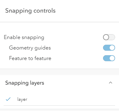
This is included in the Sketch widget by default. In the future, we plan to add this as part of the Editor and Measurement widgets.
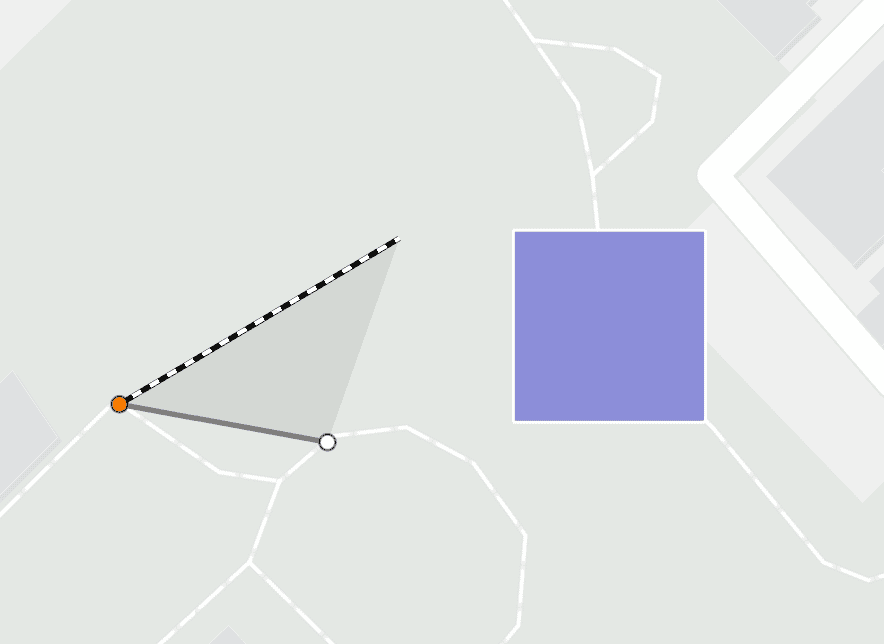
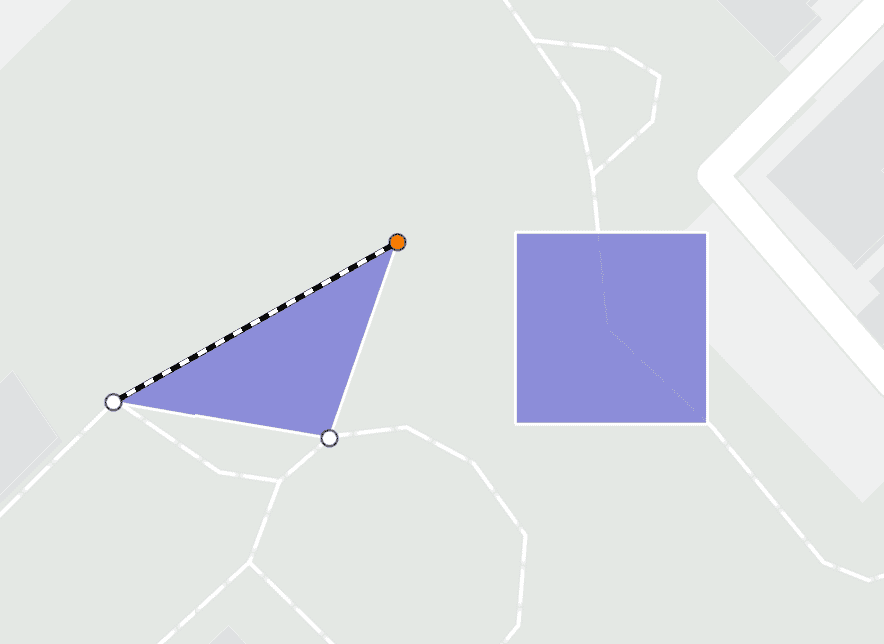
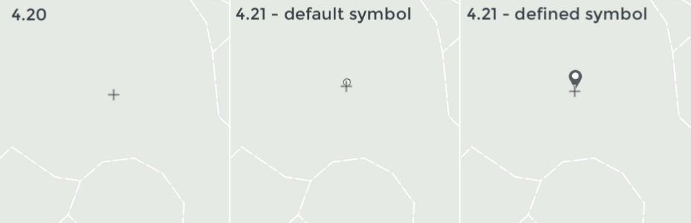
SketchViewModel - updated drawing symbology
The SketchViewModel has been updated to override the active drawing symbology, if there is a point, polygon, or polyline set. The defined graphic symbols will now be shown while in an active drawing state. In earlier versions, the defined graphic symbols set would not be visible until the drawing operation completed.
| 4.20 | 4.21 |
|---|---|
|
|
Additionally, a point symbol was added to the mouse cursor when drawing using the SketchViewModel or Sketch widget. You can override the default symbol by setting the point property.
An updated and improved Editor widget is coming
In version 4.22, we will introduce a significant update to the look and feel of the Editor's UI and workflow. In addition to the UI/UX improvements, there will be support for batch feature creation and the ability to easily work with snapping via a default UI.
Although these updates will add additional functionality and improve the overall editing experience, the user experience will deviate slightly from the current implementation. We do not anticipate any loss of functionality or breaking changes. Anything that is currently supported will continue to be supported in upcoming releases. As with any API redesign, we intend on taking these Editor updates slowly and incrementally. Version 4.22 will be the first release with these Editor updates. As it matures, additional capabilities will be implemented.
If you would like an early look at these changes, check out the /next repo where we will post early development updates.
Revised November 18, 2022
The release of the new Editor update has been postponed from its original expected 4.22 release. We are now aiming to release this at version 4.23 (March 2022). We apologize for any inconvenience this may cause. Developer builds will be made available for those that wish to test these updates. Please keep posted to the /next repo for updates.
FeatureTable - support for additional layers
The FeatureTable widget added support for the following layer types: CSVLayer, GeoJSONLayer, ImageryLayer, and WFSLayer. The FeatureTable already supported FeatureLayers and SceneLayers.
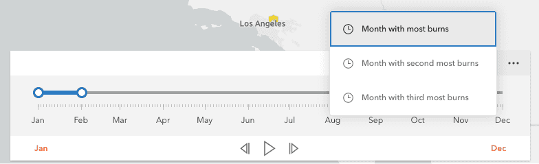
TimeSlider actions
The TimeSlider widget has been updated to support custom actions, which allows you to execute custom code such as such as setting the timeExtent to a specific date or copying the timeExtent to the browser's clipboard. The trigger-action event fires whenever an action in the menu is clicked.
Popup and Feature
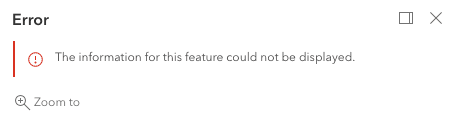
Popup error messages
The Popup widget has been updated to display an error message if any errors occur when accessing its content.
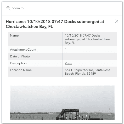
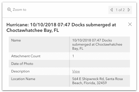
Configure what elements are queried and displayed
You can override what content is queried and displayed in the Popup or Feature widgets with the featureViewModelAbilities and abilities properties, respectively. By default, any pre-defined content types are displayed. This is useful in circumstances where there may be an already-defined popup (e.g. carried over from an existing webmap), and you don't want to query and display all of its content.
The images below show the default behavior of a popup with an associated feature attachment as opposed to the same popup without the attachment. The popup view model's featureViewModelAbilities.attachmentContent is set to false.
| Default popup displaying feature attachment | Popup with feature |
|---|---|
|
|
Search suggestions
We enhanced the Search widget suggestion behavior to make the search experience smoother and faster. First, we increased the default minimum characters required before suggestions are displayed, from 1 to 3 characters. Second, we increased performance for searching on hosted layers by refining the internal SQL query. Third, we increased the default suggestion delay before suggestions are displayed, from 150ms to 350ms.
3D updates
Local scene support for WGS84
SceneView now allows you to fully leverage your WGS84 scene layers by combining them with Web Mercator layers in local scenes.
In addition, local scenes now support geographic coordinate systems, giving you more flexibility in displaying data. Constrain the view by defining a clipping area for example.
WebGL2 support
SceneView now uses WebGL2, if available in the browser, as the underlying rendering engine. This change is the basis for future visualization capabilities and performance enhancements. WebGL1 context can still be explicitly requested for apps using externalRenderers.
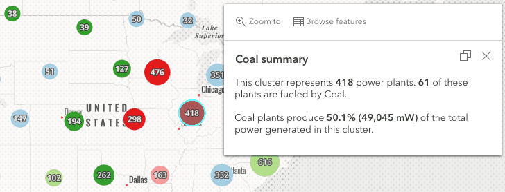
Clustering updates
You can access clustered features using Arcade expressions within the cluster popup via the $aggregated profile variable. This allows you to filter, sort, and calculate statistics on a cluster's aggregated features exclusively using Arcade.
While you can already query clustered features using JavaScript, using Arcade allows cluster popup content to be saved and persisted in webmaps so users can understand more detailed information about clusters without having to implement cluster query logic with custom JavaScript in each app that loads the webmap. This also means the popup will be persisted if the webmap is loaded in any other ArcGIS app, such as ArcGIS Pro or an app built with ArcGIS Runtime.
Check out the Clustering - filter popup features sample, which filters and displays information about a subset of features included in the cluster.
Utility Network
In the previous release, we implemented initial support for utility network, viewing associations, SubtypeGroupLayer, and simple network tracing. For this release, we improved upon network tracing by providing the ability to create custom trace configurations using the Trace class. Some of the trace settings that can be configured with this class are functions, barriers, traversability, outputs, and filters.
Tracing was also improved to return more relevant asset information after performing a trace. To learn more details about the Utility Network for this release, take a look at the following blog: What's new in Utility Network JavaScript API 4.21.
API keys
In this version, we added support for fine-grained control of API keys for
closestFacility.solve() and
serviceArea.solve() methods.
The closest method uses a new ClosestFacilityParameters.apiKey property,
and the service method uses a new ServiceAreaParameters.apiKey property.
Both methods work with either a global or a fine-grained API key.
Smart mapping updates
All smart mapping functions, including those that generate renderers, popups, labels, statistics, and clustering configurations, now support OGCFeatureLayer.
WebMap persistence updates
Layer effects can be persisted in the WebMap. This allows for easier configuration of effects — you can use the Map Viewer to explore effects and configure them in your WebMap, then those predefined effects will show in any apps where the WebMap is used.
WMSLayer and WMTSLayer can also be persisted in a WebMap at version 4.21.
Content Security Policy
Most CSP directives are supported and certified within the ArcGIS Maps SDK for JavaScript. Both 3D functionality and the projection engine makes use of WebAssembly (wasm). Wasm requires unsafe-eval in the script-src directive. Adding this in CSP goes against the protection that it is supposed to provide. There is a WebAssembly GitHub proposal that discusses this in more detail. Until this is addressed, applications that make use of these two parts of the API will not be able to take advantage of using CSP.
Documentation updates
Calcite Design System guide page
This new guide page details how you can use the Calcite Design System in your applications. Browse the library of Calcite icons and view samples that use Calcite components with the ArcGIS Maps SDK for JavaScript.
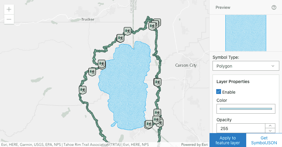
CIM Symbol Builder - support for lines and polygons
The CIM Symbol Builder has been updated to support line and polygon symbols. Combine different symbol layers, update symbol layer properties, and watch how the CIMSymbol updates. When you've created your perfect symbol, get the symbol JSON and use it to create CIMSymbols in your own applications.
Added classes, properties, methods, events
- esri/networks/support/TraceConfiguration
- esri/rest/support/NetworkFeatureSet
- esri/rest/support/NetworkUrl
- esri/support/timeUtils
- esri/widgets/ShadowCast
- esri/widgets/ShadowCast/ShadowCastViewModel
- esri/widgets/support/SnappingControls
- esri/widgets/support/SnappingControls/SnappingControlsViewModel
esri/layers/Imagery Layer - Added methods: queryObjectIds, queryRasterCount
esri/widgets/Feature/ Feature View Model esri/widgets/Popup/ Popup View Model - Added properties: featureViewModelAbilities, featureViewModels
esri/widgets/Time Slider - Added property: actions
- Added event: trigger-action
esri/widgets/Time Slider/ Time Slider View Model - Added property: actions
- Added event: trigger-action
- Added property:
orderto esri/layers/CSVLayer, esri/layers/FeatureLayer, esri/layers/GeoJSONLayer, esri/layers/OGCFeatureLayerBy - Added property:
datesto esri/layers/FeatureLayer, esri/layers/MapImageLayerIn Unknown Timezone - Added property:
sublayerto esri/layers/support/FacilityLayerInfo, esri/layers/support/LevelLayerInfo, esri/layers/support/SiteLayerInfoId - Added property:
floorto esri/layers/support/SublayerInfo - Added property:
refreshto esri/layers/WFSLayerInterval - Added property:
apito esri/rest/support/ClosestFacilityParameters, esri/rest/support/ServiceAreaParametersKey - Added property:
doto esri/rest/support/DataLayerNot Locate On Restricted Elements - Added property:
hideto esri/widgets/Legend, esri/widgets/Legend/LegendViewModel, esri/widgets/Legend/support/ActiveLayerInfoLayers Not In Current View - Added method:
fromto esri/rest/support/BufferParametersJSON - Added method:
forceto esri/views/3d/externalRenderersWeb GL Context
Deprecated classes, properties, methods, events
The following are deprecated and will be removed in a future release:
- Widget view source code: Starting at 4.21, the
.tsxwidget view source code is being deprecated for all widgets. This will be removed in a future release. Many of these files contain references to modules that are not open sourced or for internal-use only. This change does not affect the ability to build custom widgets, extend the ViewModel or customize widget CSS. - AddressCandidate deprecated since version 4.20. Use AddressCandidate instead.
- AlgorithmicColorRamp deprecated since version 4.20. Use AlgorithmicColorRamp instead.
- AreasAndLengthsParameters deprecated since version 4.20. Use AreasAndLengthsParameters instead.
- AttachmentInfo deprecated since version 4.19. Use AttachmentInfo instead.
- AttachmentQuery deprecated since version 4.20. Use AttachmentQuery instead.
- Bookmark.extent deprecated since 4.17. Use viewpoint instead.
- BufferParameters deprecated since version 4.20. Use BufferParameters instead.
- ChartMediaInfoValueSeries.x deprecated since version 4.17. Use value instead.
- ChartMediaInfoValueSeries.y deprecated since version 4.17. Use tooltip instead.
- ClosestFacilityParameters deprecated since version 4.20. Use ClosestFacilityParameters instead.
- ClosestFacilitySolveResult deprecated since version 4.20. Use ClosestFacilitySolveResult instead.
- ClosestFacilityTask deprecated since version 4.20. Use closestFacility instead.
- ColorRamp deprecated since version 4.20. Use ColorRamp instead.
- DataFile deprecated since version 4.20. Use DataFile instead.
- DataLayer deprecated since version 4.20. Use DataLayer instead.
- decorators.cast(classFunction) deprecated since version 4.14. Parameter decorators won't be supported by JavaScript decorators.
- decorators.declared deprecated since version 4.16.
declared()is not needed to extend Accessor anymore. See Implementing Accessor for updated information. - DensifyParameters deprecated since version 4.20. Use DensifyParameters instead.
- DirectionsFeatureSet deprecated since version 4.20. Use DirectionsFeatureSet instead.
- DistanceParameters deprecated since version 4.20. Use DistanceParameters instead.
- FeatureSet deprecated since version 4.20. Use FeatureSet instead.
- FindParameters deprecated since version 4.20. Use FindParameters instead.
- FindResult deprecated since version 4.20. Use FindResult instead.
- FindTask deprecated since version 4.20. Use find instead.
- GeneralizeParameters deprecated since version 4.20. Use GeneralizeParameters instead.
- GeometryService deprecated since version 4.20. Use geometryService instead.
- Geoprocessor deprecated since version 4.20. Use geoprocessor instead.
- GPMessage deprecated since version 4.20. Use GPMessage instead.
- IdentifyParameters deprecated since version 4.20. Use IdentifyParameters instead.
- IdentifyResult deprecated since version 4.20. Use IdentifyResult instead.
- IdentifyTask deprecated since version 4.20. Use identify instead.
- ImageHistogramParameters deprecated since version 4.20. Use ImageHistogramParameters instead.
- ImageIdentifyParameters deprecated since version 4.20. Use ImageIdentifyParameters instead.
- ImageIdentifyResult deprecated since version 4.20. Use ImageIdentifyResult instead.
- ImageIdentifyTask deprecated since version 4.20. Use imageService instead.
- JobInfo deprecated since version 4.20. Use JobInfo instead.
- LabelClass.labelExpressionInfo.value deprecated since version 4.5. Use expression instead.
- LegendLayer deprecated since version 4.20. Use LegendLayer instead.
- LengthsParameters deprecated since version 4.20. Use LengthsParameters instead.
- LinearUnit deprecated since version 4.20. Use LinearUnit instead.
- Locator deprecated since version 4.20. Use locator instead.
- MultipartColorRamp deprecated since version 4.20. Use MultipartColorRamp instead.
- NAMessage deprecated since version 4.20. Use NAMessage instead.
- OffsetParameters deprecated since version 4.20. Use OffsetParameters instead.
- ParameterValue deprecated since version 4.20. Use ParameterValue instead.
- PointDrawAction.coordinates deprecated since version 4.19. Use vertices instead.
- Portal.createClosestFacilityTask deprecated since version 4.21.
- Portal.createGeometryService deprecated since version 4.21.
- Portal.createPrintTask deprecated since version 4.21.
- Portal.createRouteTask deprecated since version 4.21.
- Portal.createServiceAreaTask deprecated since version 4.21.
- PrintParameters deprecated since version 4.20. Use PrintParameters instead.
- PrintTask deprecated since version 4.20. Use print instead.
- PrintTemplate deprecated since version 4.20. Use PrintTemplate instead.
- projection.isSupported deprecated since version 4.18.
- ProjectParameters deprecated since version 4.20. Use ProjectParameters instead.
- promiseUtils.reject deprecated since version 4.19. Use the native Promise.reject() method instead.
- promiseUtils.resolve deprecated since version 4.19. Use the native Promise.resolve() method instead.
- Query deprecated since version 4.20. Use Query instead.
- QueryTask deprecated since version 4.20. Use query instead.
- RasterData deprecated since version 4.20. Use RasterData instead.
- RelationParameters deprecated since version 4.20. Use RelationParameters instead.
- RelationshipQuery deprecated since version 4.20. Use RelationshipQuery instead.
- RouteParameters deprecated since version 4.20. Use RouteParameters instead.
- RouteResult deprecated since version 4.20. Use RouteResult instead.
- RouteTask deprecated since version 4.20. Use route instead.
- SceneView.constraints.collision deprecated since version 4.8. Use Ground.navigationConstraint instead.
- ServiceAreaParameters deprecated since version 4.20. Use ServiceAreaParameters instead.
- ServiceAreaSolveResult deprecated since version 4.20. Use ServiceAreaSolveResult instead.
- ServiceAreaTask deprecated since version 4.20. Use serviceArea instead.
- SizeVariable.expression deprecated since version 4.2. Use SizeVariable.valueExpression instead.
- Slider.labelsVisible deprecated since version 4.15. Use Slider.visibleElements.labels instead.
- Slider.rangeLabelsVisible deprecated since version 4.15. Use Slider.visibleElements.rangeLabels instead.
- StatisticDefinition deprecated since version 4.20. Use StatisticDefinition instead.
- symbolPreview.renderPreviewHTML deprecated since version 4.11. Use symbolUtils.renderPreviewHTML instead.
- symbolPreview deprecated since version 4.11. Use symbolUtils instead.
- Task deprecated since version 4.20.
- TimeSlider.values deprecated since version 4.20. Use timeExtent instead.
- TimeSliderViewModel.values deprecated since version 4.20. Use timeExtent instead.
- TrimExtendParameters deprecated since version 4.20. Use TrimExtendParameters instead.
- widget.renderable deprecated since version 4.19. All properties are automatically tracked now and don't need to be decorated with this decorator.
Smartdeprecated since version 4.13. UseMapping.params.basemap viewinstead.- The light-blue, dark-blue, light-green, dark-green, light-purple, dark-purple, light-red, dark-red are deprecated since 4.19. Please use
lightordarkinstead, or create your own theme.
Breaking changes
- Field configurations can no longer be set on the FeatureForm. Instead, configure the fields via the FieldElement or GroupElement. Set these elements on either the form or feature layer's formTemplate.
- ShadowAccumulation widget has been renamed to ShadowCast widget.
- ShadowAccumulationViewModel has been renamed to ShadowCastViewModel.
- The FeatureForm widget has changed the way it handles a value’s input. Prior to version 4.21, field values were processed and applied using
on. Moving forward, this has been updated to useBlur onwith values getting validated as a user types. Date values will only be appliedInput onif the value is valid. It will subsequently be committed or discardedInput onbased on the final value.Blur
The following classes, methods, properties and events have been deprecated for at least 2 releases and have been removed from the API:
| Class/Property/Method/Event | Alternate option | Version deprecated |
|---|---|---|
Basemap | BasemapLayerList.visibleElements.statusIndicators | 4.15 |
Bookmarks.bookmark | Bookmarks.defaultCreateOptions | 4.18 |
esri/tasks/ | imageService.identify | 4.18 |
esri/tasks/support/ | ImageIdentifyResult | 4.18 |
esri/tasks/support/ | ImageIdentifyParameters | 4.18 |
Feature and Feature | FormTemplate.description set either on the FeatureForm or FeatureLayer formTemplate | 4.18 |
Feature and Feature | FieldElement/GroupElement set in the FormTemplate.elements | 4.16 |
Feature and Feature | FormTemplate.title set either on the FeatureForm or FeatureLayer formTemplate | 4.18 |
Layer | LayerList.visibleElements.statusIndicators | 4.15 |
Please refer to the Breaking changes guide topic for a complete list of breaking changes across all releases of the 4x API.
Bug fixes and enhancements
- BUG-000132900: Fixed an issue with WMTSLayer requesting tiles that were not within the coverage of the TileMatrix.
- BUG-000135406: Fixed an issue where switching renderers on a FeatureLayer with clustering enabled did not update the symbology until the
Mapwas panned or zoomed. - BUG-000137190: Fixed an issue where labels in a VectorTileLayer render irrespective of the style layer's visibility range.
- BUG-000140810: Groups within the FeatureForm widget no longer fail to open read-only fields when set to display sequentially.
- BUG-000141284: Fixed an issue with WMSLayer where custom parameters would be added to the GetLegendGraphic request with a
?instead of an&, causing the request to fail. - BUG-000141323: Fixed an issue with SketchViewModel where creating a polygon with
defaultfailed withCreate Options.has Z = true cannot read property '0' of undefined. This also affected the Editor on polygon layers withhas.Z = true - BUG-000141553: Fixed an issue where the locationToAddress() method was missing a URL parameter.
- BUG-000141653: Fixed an issue where using a Gamepad causes the MapView to stop responding after changing web maps.
- BUG-000141956: Fixed an issue where the
doproperty was sent as a standalone parameter rather than as part of DataLayer, NetworkFeatureSet, or NetworkUrl.Not Locate On Restricted Elements - BUG-000142000: Fixed an issue where the listItemCreatedFunction of the LayerList widget gets called an excessive number of times.
- BUG-000142027: Fixed an issue with the DistanceMeasurement2D widget returning incorrect readings at very large scales.
- BUG-000142800: Fixed an issue with 2D FeatureLayer labels failing to display for one layer when there are overlapping identical layers.
- Esri Community - 1085769: Fixed a regression with being unable to create a single point multipoint graphic with SketchViewModel.
- Esri Community - 1086457: Fixed an issue where editingEnabled was returning true even if the feature layer wasn't editable.
- Esri Community - 1087391: Fixed an issue where CIMTextSymbol were getting cut off within a CIMSymbol.
- Esri Community - 1093495: Fixed an issue where
primitivewere not being applied to CIMPictureMarker symbol layers in CIMSymbols.Overrides - Fixed an issue in SketchViewModel where scaling graphics was still possible despite setting
enable.Scaling = false - Fixed an issue when signing into multiple authenticated layers from federated sources. The modal dialog now displays as expected, i.e. one at a time, when the user clicks
cancel. - Fixed an issue where layer effects were not being applied to ImageryLayer.
- Fixed an issue where Layer.fromPortalItem() was not working with WMTSLayer portal items.
- Fixed an issue where Legend didn't correctly display above and below theme when per feature transparency was enabled.
- Fixed an issue where Legend didn't correctly display custom symbols.
- Fixed an issue where Legend flickered when using a slider to adjust transparency on a MapImageLayer sublayer.
- Fixed an issue where MapImageLayer made multiple requests for legends.
- Fixed an issue where returnDistinctValues queries returned incorrect results when used on LayerViews.
- Fixed an issue where VectorFieldRenderer would not update when used with the TimeSlider widget.
- Fixed an issue where websocket events were not being emitted when StreamLayer.geometryDefinition was being set on a map pan.
- Fixed an issue with CIMSymbol where the
tintwas not applied toColor CIMsymbols.Picture Marker - Fixed an issue with clustered labels where they didn't render properly on edges of the view.
- ENH-000138022: Added the hideLayersNotInCurrentView property to the Legend widget. This property determines whether the Legend displays layers visible in the current view extent.
- ENH-000131075: Added the orderBy property to the FeatureLayer to order and draw features based on attribute values.
- Esri Community - 1069711: Enhanced the CoordinateConversion widget's
Copy to clipboardpopup to be smaller and more subdued. - Enhanced the geodesicUtils.geodesicDistance() method to return
azimuthandreversevalues in the range of 0-360°.Azimuth - Improved navigation performance in 3D.
- Updated the Editor widget to temporarily disable either the
UpdateorAddbuttons afteron. This stops duplicateClick applyrequests from being sent if either of these buttons are accidentally clicked before the edit process is finished.Edits - WFSLayer can now be added to a web scene.
Additional packages
Version 4.21 of the ArcGIS Maps SDK for JavaScript uses ArcGIS Arcade 1.15 (since 4.21).
Downloads
The API installation has been simplified, so you no longer need to modify any files. Just download and start using. We've also added a test application to the API downloads to quickly verify your API installation.
How to access the SDK
- The API library is available on both CDN and npm, Read more at Get started.
- For supported versions, you can also download both the documentation and the API library. These downloads are typically available 3-4 weeks after release.
Previous releases
- Version 4.29 - February 2024
- Version 4.28 - October 2023
- Version 4.27 - June 2023
- Version 4.26 - February 2023
- Version 4.25 - November 2022
- Version 4.24 - June 2022
- Version 4.23 - March 2022
- Version 4.22 - December 2021
- Version 4.21 - September 2021