April 2021
ES modules - production release
The API's ES modules are now ready for production use, they were originally released in beta at version 4.18. These modules make it easier to do local builds of the API when integrating with third party frameworks and build tools. They are available for installation via the NPM package @arcgis/core.
Install the modules by running npm i @arcgis/core. Then, you can use native imports like this:
import WebMap from "@arcgis/core/WebMap";
import MapView from "@arcgis/core/views/MapView";The benefits of this approach include:
- Simplified code
- Native support in modern browsers
- Minimal configuration
- Seamless integration with all modern frameworks and build tools
Visit the Introduction to tooling guide topic to learn more about the new modules and whether you should migrate. There are also sample apps that demonstrate the basic concepts for getting started.
Assets for local builds
NPM installs of @arcgis/core and arcgis-js-api for local builds now use a CDN as the default way to retrieve assets at runtime. The assets include styles, images, web workers, wasm and localization files. The new default setting will make initial installs and configuration much easier, and can still be overridden using config.assets when working with local assets.
Performance improvements
At this release, we improved the performance of point FeatureLayers hosted on ArcGIS Online. The FeatureLayer will now fetch all its features at once from the server. Once loaded, the features won't need to be re-requested from the server, which will make future redraws after panning and zooming much faster. We will continue to add support for other feature services in the next few upcoming releases.
Editing updates
Snapping
Self snapping support added to 2D
Self-snapping is now supported when creating or updating line and polygon features in 2D. This makes it easier to create geometries that have parallel lines
and right angles. To enable snapping, set the snapping property to true
in the Sketch or Editor widget. 3D support for self snapping was previously implemented in 4.18, and is now no longer in beta.
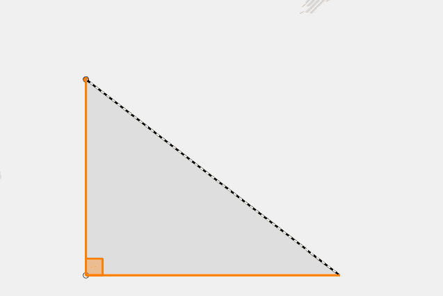
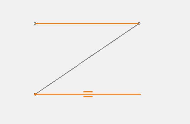
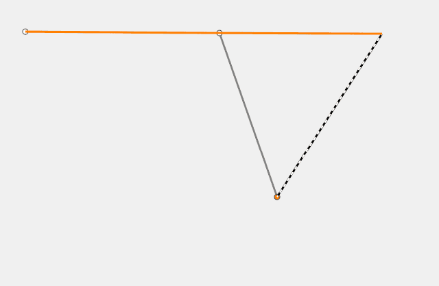
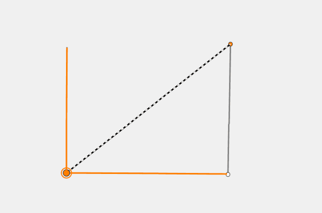
Self snapping will snap to perpendicular lines (right angles), parallel lines, an extension of a line, and to a vertex of the feature being edited, as shown in the images below.
| Perpendicular lines | Parallel lines | Extension of a line | Vertex |
|---|---|---|---|
|
|
|
|
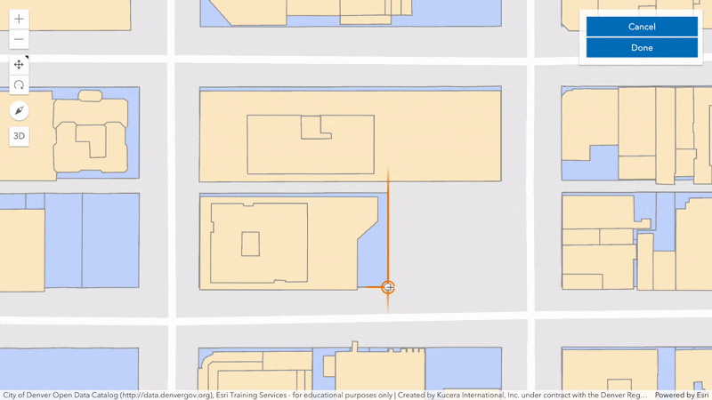
Feature snapping now supported in 2D and 3D
We also added support for feature snapping in both 2D and 3D. Now, it is possible to snap to existing features from a FeatureLayer,
GraphicsLayer, GeoJSONLayer, or
CSVLayer currently loaded on the Map. In order to utilize feature snapping, the Snapping must be assigned to one
or more of the layers on the map.
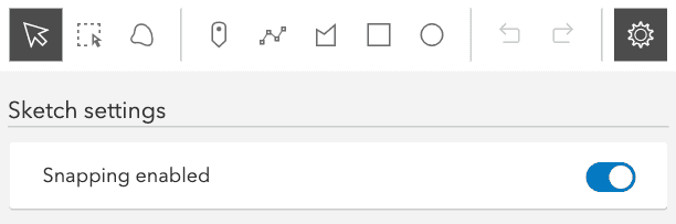
Enable snapping in the Sketch widget
The Sketch widget's UI now includes an options menu to toggle snapping on/off. This control toggles the Sketch.snapping property. By default,
snapping is disabled, but it can be enabled either by toggling the switch in the widget's UI, or by holding the Ctrl key while drawing a graphic.
Editor widget
Snapping in Editor
The Editor widget now provides the ability to set snapping when creating or updating features. This is all handled programmatically via the API by setting the snappingOptions property. The snappingOptions object contains various properties for configuring sketch snapping. These configurations include enabling/disabling both self and feature snapping. Information on these two forms of snapping is provided in the SnappingOptions documentation. In addition, please refer to this documentation for any known limitations while working with snapping.
Examples showing this functionality are provided in the updated Edit features with the Editor widget, Editor widget with configurations, and Edit features in 3D with the Editor widget samples.
Currently, the snapping functionality offered in the Editor widget does not provide a UI similar to that of the Sketch widget. This behavior will change in upcoming releases with an updated UI to help with configuring snapping options.
Other improvements
The Editor widget will now automatically disable the view's popup when selecting a feature to edit. It is no longer necessary to add a line similar to the following:
view.popup.autoOpenEnabled = false; // no longer necessary to add when using the Editor to edit existing featuresFeatureForm
Additional input types have been added to FormTemplate field elements. These input types include:
API keys
In version 4.18, we added support for a global API key to use with Location Services. Version 4.19 builds on top of that and makes it easier to use by supporting more fine-grained control of API keys, easier to work in conjunction with ArcGIS Identity, as well as improving default services when API key is used.
- When using a global API key, the Search and Directions widgets will automatically default to the correct services. See Directions sample.
- New apiKey property on Directions widget.
- New apiKey property on RouteParameters. Useful if using the RouteTask outside the Directions widget. See RouteTask sample.
- New apiKey property on LocatorSearchSource (for use with Search widget's sources property). See "Search widget with multiple sources" sample.
3D updates
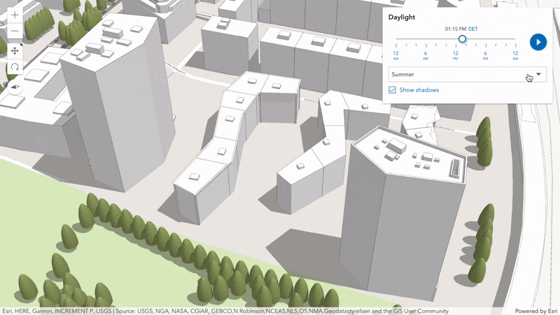
Shadow highlight
Identify the shadow of individual 3D objects, such as buildings or trees, when clicking on the feature or calling highlight(). Combining the new shadow highlight with the Daylight widget you can determine how each building contributes to a certain shadowed area, for any season and time of day. You can configure the strength of the highlight by setting the new SceneView property highlight and additional opacity settings to allow you to differentiate shadows that overlap with the highlighted one.
Line and polygon transformations
Interactively scale and rotate line and polygon geometries using the Sketch and Editor widgets. Clicking on a line or polygon being updated will toggle between reshaping and transforming the feature. The available modes can be customized through the SketchViewModel.defaultUpdateOptions settings. To scale a geometry by keeping its proportions, keep the CTRL button pressed during the transformation.
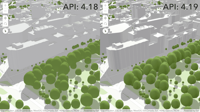
Improved rendering quality
A new lighting and shading model adds more contrast and definition to your 3D content. With the 4.19 release, existing scenes will benefit from this visual improvement when SceneView.qualityProfile is set to medium or high. Additionally, objects with Physically-Based Rendering (PBR) materials, such as used in WebStyleSymbols, display light reflections on glass or metallic surfaces.
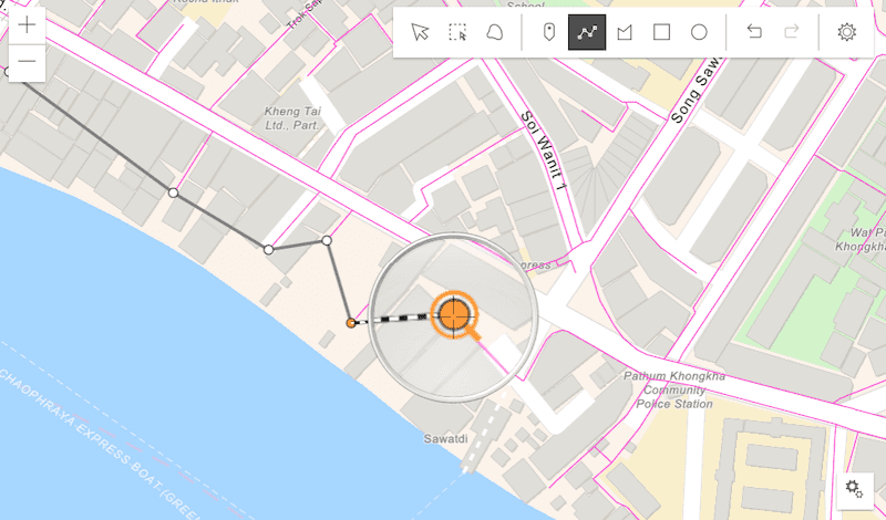
Magnifier
Added a Magnifier to the MapView and SceneView, which displays a portion of the view as a magnified image. The Magnifier can improve the editing and drawing experience of applications utilizing the Sketch and Editor widgets, especially when pairing with the new snapping functionality.
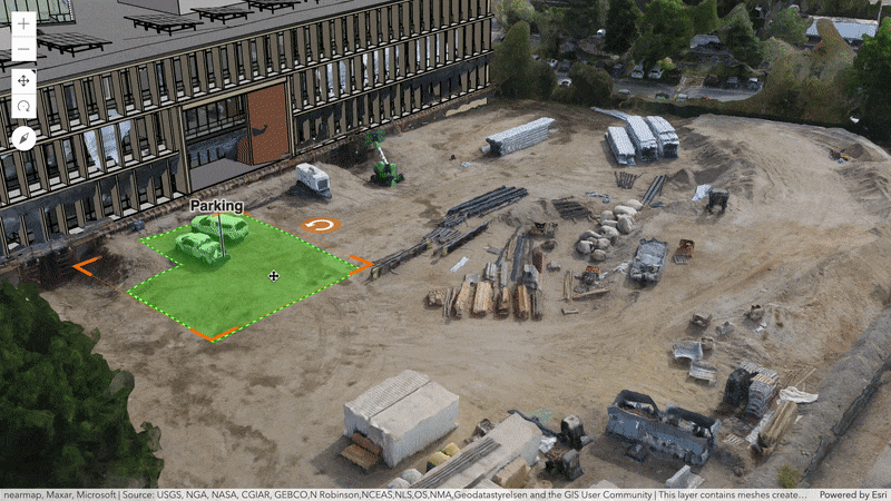
Floor awareness
Floor-aware maps and layers
We introduced floor awareness, which brings indoor GIS data representing floor plan features to your maps and layers.
You can now specify the floor property in your WebMap, WebScene,
FeatureLayer, or SceneLayer to make your map or scene floor-aware.
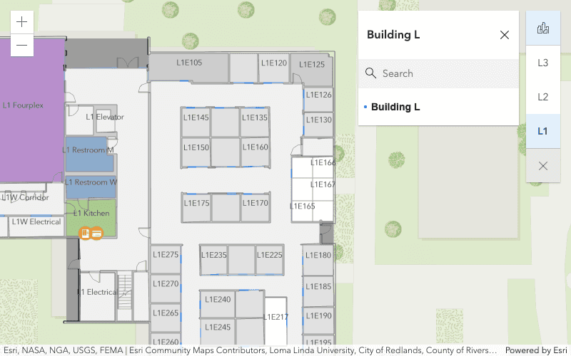
FloorFilter widget
The FloorFilter widget filters features from floor-aware layers to control
visualization in both MapView and SceneView. Once you have defined the floor for a map or scene, you can use the
FloorFilter widget to interactively filter your floor plan data.
Widget updates
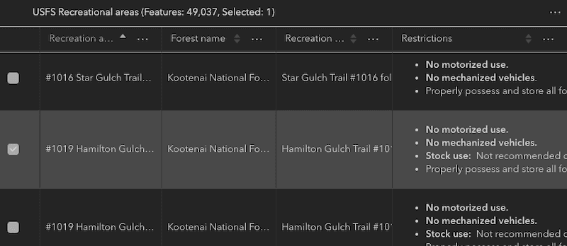
FeatureTable
Filter the table by geometry or extent
It is now possible to filter out what is displayed within the table. This functionality is handled via the filterGeometry property. It works by passing in a Geometry and any features that intersect it are displayed within the table. You can see how this works in the updated FeatureTable widget with map sample.
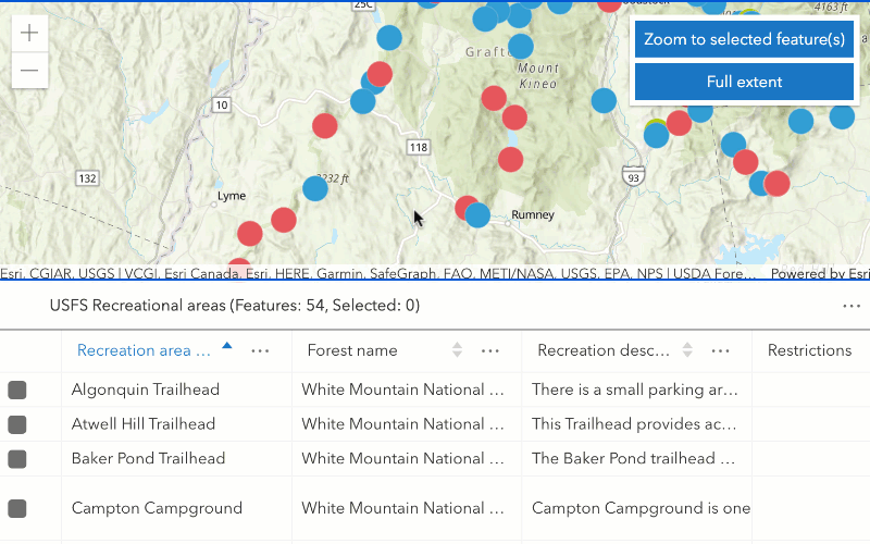
Improved theme compatibility
The FeatureTable widget was enhanced to improve compatibility with the API themes provided out-of-the-box. The FeatureTable now takes advantage of the dark theme, which was not available in previous releases. The light-theme compatibility was also improved.
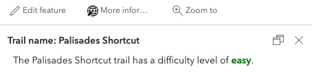
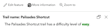
Popup
The Popup widget now dynamically displays content in the header and footer to handle longer strings. This can be seen when displaying action text with a large amount of characters.
| 4.18 | 4.19 |
|---|---|
|
|
In addition to the UI update mentioned above, two additional title and description properties were added for the Attachments, Fields, and Media content elements. This is shown below in the various screen captures.
| Attachments | Fields | Media |
|---|---|---|
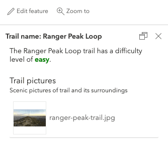
|
|
|
Directions
The Directions widget now allows a Time Unspecified departure option.
This uses the average travel time to calculate estimated travel durations.
Promises
All widgets now support the following methods: when(), i, i, and i.
You can use these methods to return a promise when the widget is created or to verify if the widget was created successfully.
// Add the BasemapGallery to the view only one the widget has been instantiated
const bmGallery = new BasemapGallery();
bmGallery.when(() => {
// This function will execute once the promise is resolved
view.ui.add(bmGallery);
}, (error) => {
// This function will execute if the promise is rejected due to an error
});Layer updates
OGCFeatureLayer spatial references
The OGCFeatureLayer now supports OGC API - Features - Part 2, which provides support for additional spatial references. Previously only WGS84 was supported. Now, all OGCFeatureLayers will work in WGS84 and WebMercator, along with any other spatial references provided by the service.
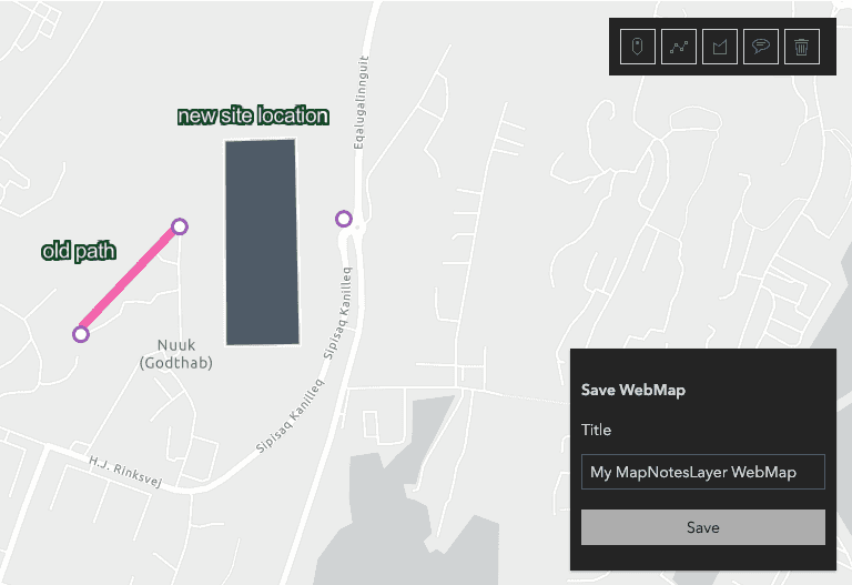
MapNotesLayer - editing support
The MapNotesLayer can now be edited if it was created in the new Map Viewer.
Map notes can be added, updated, and deleted - allowing you to easily sketch, add, remove, or update notes from any map, then persist your changes using Web.
Map notes created with Map Viewer Classic can be displayed, but the map notes cannot be modified or accessed with this class. Check out the MapNotesLayer sample to see it in action.
GroupLayer
GroupLayer now supports minScale and maxScale properties. The 2D MapView will support scale range defined for a group layer. For a child layer in a group to be visible, the view scale should intersect the scale range defined for the child as well as all its parent group layers.
VectorTileLayer - support for expressions
At this release, we added a full support for lookup, ramp, variable binding, color, math (with an exception of distance), and zoom expressions and a limited support for type, feature data, decision, and string expressions. We will continue to add support for all expressions in coming releases.
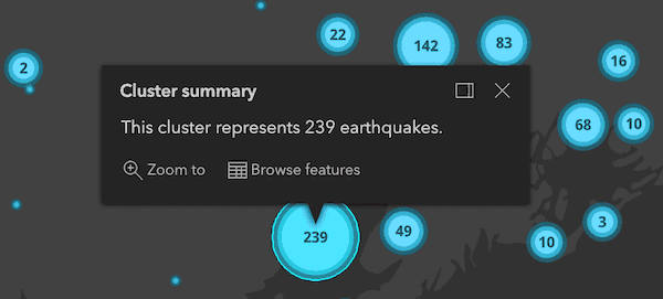
Browse cluster features
We added Browse features as a new default action to the cluster popup. This allows you to browse and select individual features included in a cluster directly from the cluster popup. The Zoom to action was updated to zoom to the extent of a cluster's features. You can explore these new actions in any of the cluster samples. Also, point clustering is no longer in beta.
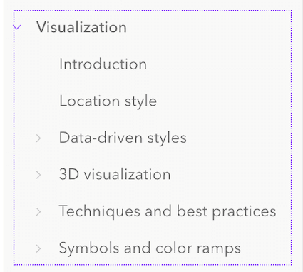
Data visualization guide
The data visualization guide was revamped with more than 20 new conceptual topics and four chapters. Explore the guide to learn about visualization best practices, the various layer styles available in the JS API, and browse the hundreds of symbols and color ramps provided for easy copy/paste use in your apps.
Smart mapping updates
Added normalization to support various transformations in histogram and summary statistics. Includes support for normalization-total, log, natural-log, and square-root. Check out the histogram sample to explore these new normalization types.
We also added 20 new color ramps to the Color ramps guide.
IdentityManager update
Two methods, enablePostMessageAuth and disablePostMessageAuth, were added to the IdentityManager to help make passing authentication from an embedded application using an iframe to its host application easier to manage. This is necessary as problems could arise if a user is logged into a web application containing an embedded application that is not public. If this scenario occurs, its easier to pass the already-provided credentials to the secured embedded application.
rest modules
We've ported the majority of Tasks functionality to simple functional rest modules. This will make it easier to incorporate into a more modular app design,
and also reduce unnecessary dependencies (you only import what you want). The next release will see the rest of the Tasks ported over, and then we will deprecate Tasks.
Note that esri/layers/support/Attachment has been moved to esri/rest/query/support/AttachmentInfo.
Added classes, properties, methods, events
- esri/form/elements/inputs/BarcodeScannerInput
- esri/form/elements/inputs/ComboBoxInput
- esri/form/elements/inputs/RadioButtonsInput
- esri/layers/support/FacilityLayerInfo
- esri/layers/support/GeometryFieldsInfo
- esri/layers/support/LayerFloorInfo
- esri/layers/support/LevelLayerInfo
- esri/layers/support/SiteLayerInfo
- esri/renderers/visualVariables/support/ColorSizeStop
- esri/rest/closestFacility
- esri/rest/find
- esri/rest/geometryService
- esri/rest/geoprocessor
- esri/rest/geoprocessor/GPOptions
- esri/rest/identify
- esri/rest/imageService
- esri/rest/locator
- esri/rest/query
- esri/rest/query/support/AttachmentInfo
- esri/rest/route
- esri/rest/serviceArea
- esri/support/MapFloorInfo
- esri/views/interactive/snapping/FeatureSnappingLayerSource
- esri/views/interactive/snapping/SnappingOptions
- esri/views/Magnifier
- esri/widgets/FloorFilter
- esri/widgets/FloorFilter/FloorFilterViewModel
esri/identity/IdentityManager - Added methods: disablePostMessageAuth, enablePostMessageAuth
esri/layers/FeatureLayer - Added properties: floorInfo, geometryFieldsInfo
esri/layers/GroupLayer esri/layers/ImageryTile Layer - Added property: rasterInfo to
esri/layers/ImageryTile Layer - Added method: fetchPixels to
esri/layers/ImageryTile Layer
- Added property: rasterInfo to
esri/layers/MapNotes Layer - Added properties: capabilities, multipointLayer, pointLayer, polygonLayer, polylineLayer, textLayer
esri/layers/WCSLayer- Added property: rasterInfo to
esri/layers/WCSLayer - Added method: fetchPixels to
esri/layers/WCSLayer
- Added property: rasterInfo to
esri/popup/content/AttachmentsContent - Added properties: description, title
esri/popup/content/FieldsContent - Added properties: description, title
esri/popup/content/MediaContent - Added properties: activeMediaInfoIndex, description, title
esri/tasks/support/JobInfo - Added properties: requestOptions, sourceUrl
- Added methods: cancelJob, fetchResultData, fetchResultImage, fetchResultMapImageLayer
esri/views/draw/PointDraw Action esri/views/MapView esri/views/SceneView esri/widgets/CoordinateConversion - Added property: visibleElements to
esri/widgets/CoordinateConversion
- Added property: visibleElements to
esri/widgets/Daylight- Added property: iconClass to
esri/widgets/Daylight
- Added property: iconClass to
esri/widgets/Directions- Added property: apiKey to
esri/widgets/Directions
- Added property: apiKey to
esri/widgets/Editor- Added property: snappingOptions to
esri/widgets/Editor
- Added property: snappingOptions to
esri/widgets/Expand- Added property: closeOnEsc to
esri/widgets/Expand
- Added property: closeOnEsc to
esri/widgets/FeatureForm/Field Config - Added properties: noValueOptionLabel, showNoValueOption
esri/widgets/FeatureTable - Added properties: filterGeometry, menu, pageSize
- Added method: scrollToIndex
esri/widgets/FeatureTable/Feature Table View Model - Added property: filterGeometry to
esri/widgets/FeatureTable/Feature Table View Model - Added method: scrollToIndex to
esri/widgets/FeatureTable/Feature Table View Model
- Added property: filterGeometry to
esri/widgets/FeatureTable/Field Column Config - Added properties: noValueOptionLabel, showNoValueOption
esri/widgets/LineOf Sight - Added property: iconClass to
esri/widgets/LineOf Sight
- Added property: iconClass to
esri/widgets/Locate- Added property: popupEnabled to
esri/widgets/Locate
- Added property: popupEnabled to
esri/widgets/Popup- Added property: featureMenuOpen to
esri/widgets/Popup
- Added property: featureMenuOpen to
esri/widgets/Popup/PopupView Model - Added properties: defaultActions, includeDefaultActions, selectedClusterBoundaryFeature
esri/widgets/Sketch- Added property: snappingOptions to
esri/widgets/Sketch
- Added property: snappingOptions to
esri/widgets/Slice- Added property: iconClass to
esri/widgets/Slice
- Added property: iconClass to
esri/widgets/smartMapping/Color Size Slider - Added property: persistSizeRangeEnabled to
esri/widgets/smartMapping/Color Size Slider
- Added property: persistSizeRangeEnabled to
esri/widgets/smartMapping/Size Slider - Added property: persistSizeRangeEnabled to
esri/widgets/smartMapping/Size Slider
- Added property: persistSizeRangeEnabled to
esri/widgets/Widget- Added methods: isFulfilled, isRejected, isResolved, when
- Added property:
floorto esri/layers/FeatureLayer, esri/layers/SceneLayer, esri/WebMap, esri/WebSceneInfo - Added property:
geometryto esri/layers/FeatureLayerFields Info - Added property:
maxto esri/layers/GroupLayerScale - Added property:
minto esri/layers/GroupLayerScale - Added property:
bandto esri/layers/ImageryLayerIds - Added property:
rasterto esri/layers/ImageryTileLayer, esri/layers/WCSLayerInfo - Added property:
capabilitiesto esri/layers/MapNotesLayer - Added property:
multipointto esri/layers/MapNotesLayerLayer - Added property:
pointto esri/layers/MapNotesLayerLayer - Added property:
polygonto esri/layers/MapNotesLayerLayer - Added property:
polylineto esri/layers/MapNotesLayerLayer - Added property:
textto esri/layers/MapNotesLayerLayer - Added property:
descriptionto esri/popup/content/AttachmentsContent, esri/popup/content/FieldsContent, esri/popup/content/MediaContent - Added property:
titleto esri/popup/content/AttachmentsContent, esri/popup/content/FieldsContent, esri/popup/content/MediaContent - Added property:
activeto esri/popup/content/MediaContentMedia Info Index - Added property:
ito esri/popup/FieldInfos Editable - Added property:
requestto esri/tasks/support/JobInfoOptions - Added property:
sourceto esri/tasks/support/JobInfoUrl - Added property:
apito esri/tasks/support/RouteParameters, esri/widgets/Directions, esri/widgets/Directions/DirectionsViewModel, esri/widgets/Search/LocatorSearchSourceKey - Added property:
verticesto esri/views/draw/DrawAction, esri/views/draw/PointDrawAction - Added property:
hasto esri/views/draw/MultipointDrawAction, esri/views/draw/PointDrawAction, esri/views/draw/PolygonDrawAction, esri/views/draw/PolylineDrawAction, esri/views/draw/SegmentDrawActionZ - Added property:
floorsto esri/views/MapView, esri/views/SceneView - Added property:
magnifierto esri/views/MapView, esri/views/SceneView, esri/views/View - Added property:
visibleto esri/widgets/CoordinateConversionElements - Added property:
iconto esri/widgets/Daylight, esri/widgets/LineOfSight, esri/widgets/SliceClass - Added property:
snappingto esri/widgets/Editor, esri/widgets/Editor/EditorViewModel, esri/widgets/SketchOptions - Added property:
closeto esri/widgets/ExpandOn Esc - Added property:
nto esri/widgets/FeatureForm/FieldConfig, esri/widgets/FeatureTable/FieldColumnConfigo Value Option Label - Added property:
showto esri/widgets/FeatureForm/FieldConfig, esri/widgets/FeatureTable/FieldColumnConfigNo Value Option - Added property:
filterto esri/widgets/FeatureTable, esri/widgets/FeatureTable/FeatureTableViewModelGeometry - Added property:
menuto esri/widgets/FeatureTable - Added property:
pageto esri/widgets/FeatureTableSize - Added property:
popupto esri/widgets/Locate, esri/widgets/Locate/LocateViewModelEnabled - Added property:
featureto esri/widgets/PopupMenu Open - Added property:
defaultto esri/widgets/Popup/PopupViewModelActions - Added property:
includeto esri/widgets/Popup/PopupViewModelDefault Actions - Added property:
selectedto esri/widgets/Popup/PopupViewModelCluster Boundary Feature - Added property:
persistto esri/widgets/smartMapping/ColorSizeSlider, esri/widgets/smartMapping/ColorSizeSlider/ColorSizeSliderViewModel, esri/widgets/smartMapping/SizeSlider, esri/widgets/smartMapping/SizeSlider/SizeSliderViewModelSize Range Enabled - Added method:
disableto esri/identity/IdentityManagerPost Message Auth - Added method:
enableto esri/identity/IdentityManagerPost Message Auth - Added method:
fetchto esri/layers/ImageryTileLayer, esri/layers/WCSLayerPixels - Added method:
getto esri/layers/support/fieldUtilsFeature Geometry Fields - Added method:
getto esri/symbols/support/symbolUtilsDisplayed Color - Added method:
cancelto esri/tasks/support/JobInfoJob - Added method:
fetchto esri/tasks/support/JobInfoResult Data - Added method:
fetchto esri/tasks/support/JobInfoResult Image - Added method:
fetchto esri/tasks/support/JobInfoResult M a p Image Layer - Added method:
scrollto esri/widgets/FeatureTable, esri/widgets/FeatureTable/FeatureTableViewModelTo Index - Added method:
formatto esri/widgets/smartMapping/support/utilsNumber Label
Deprecated classes, properties, methods, events
The following are deprecated and will be removed in a future release:
- AttachmentInfo deprecated since version 4.19. Use AttachmentInfo instead.
- BasemapLayerList.statusIndicatorsVisible deprecated since version 4.15. Use BasemapLayerList.visibleElements.statusIndicators instead.
- Bookmark.extent deprecated since 4.17. Use viewpoint instead.
- Bookmarks.bookmarkCreationOptions deprecated since 4.18. Use defaultCreateOptions instead.
- Bookmarks.select-bookmark deprecated since version 4.17. Use bookmark-select instead.
- BookmarksViewModel.BookmarkCreationOptions.captureExtent deprecated since version 4.17. Use
captureinstead.Viewpoint - ChartMediaInfoValueSeries.x deprecated since version 4.17. Use value instead.
- ChartMediaInfoValueSeries.y deprecated since version 4.17. Use tooltip instead.
- decorators.cast(classFunction) deprecated since version 4.14. Parameter decorators won't be supported by JavaScript decorators.
- decorators.declared deprecated since version 4.16.
declared()is not needed to extend Accessor anymore. See Implementing Accessor for updated information. - FeatureForm.fieldConfig deprecated since version 4.16. Use FieldElement and/or GroupElement instead.
- FeatureFormViewModel.fieldConfig deprecated since version 4.16. Use FieldElement and/or GroupElement instead.
- FeatureTemplates.filterEnabled deprecated since version 4.15. Use FeatureTemplates.visibleElements.filter instead.
- ImageServiceIdentifyParameters deprecated since version 4.18. Use ImageIdentifyParameters instead.
- ImageServiceIdentifyResult deprecated since version 4.18. Use ImageIdentifyResult instead.
- ImageServiceIdentifyTask deprecated since version 4.18. Use ImageIdentifyTask instead.
- LabelClass.labelExpressionInfo.value deprecated since version 4.5. Use expression instead.
- LayerList.statusIndicatorsVisible deprecated since version 4.15. Use LayerList.visibleElements.statusIndicators instead.
- PathSymbol3DLayer.size deprecated since version 4.12. Use PathSymbol3DLayer.width or PathSymbol3DLayer.height instead.
- PointDrawAction.coordinates deprecated since version 4.19. Use vertices instead.
- Popup.featureNavigationEnabled deprecated since version 4.15. Use Popup.visibleElements.featureNavigation instead.
- projection.isSupported deprecated since version 4.18.
- promiseUtils.reject deprecated since version 4.19. Use the native Promise.reject() method instead.
- promiseUtils.resolve deprecated since version 4.19. Use the native Promise.resolve() method instead.
- SceneView.constraints.collision deprecated since version 4.8. Use Ground.navigationConstraint instead.
- SizeVariable.expression deprecated since version 4.2. Use SizeVariable.valueExpression instead.
- Slider.labelsVisible deprecated since version 4.15. Use Slider.visibleElements.labels instead.
- Slider.rangeLabelsVisible deprecated since version 4.15. Use Slider.visibleElements.rangeLabels instead.
Smartdeprecated since version 4.13. UseMapping.params.basemap viewinstead.- symbolPreview.renderPreviewHTML deprecated since version 4.11. Use symbolUtils.renderPreviewHTML instead.
- symbolPreview deprecated since version 4.11. Use symbolUtils instead.
- The light-blue, dark-blue, light-green, dark-green, light-purple, dark-purple, light-red, dark-red themes are deprecated since 4.19. Please use
lightordarkinstead, or create your own theme. - widget.renderable deprecated since version 4.19. All properties are automatically tracked now and don't need to be decorated with this decorator.
Breaking changes
- The IdentityManager's
setmethod andRedirection Handler useproperty were removed at 4.19. This was a result of Enterprise Portal apps no longer making use of this functionality beginning with the upcoming Enterprise 10.9.1 release.Sign In Page - The InputField and FieldElement hint property has been updated to display a temporary placeholder for text and number inputs for both TextAreaInput and TextBoxInput. Prior to this, whatever was set in the FieldElement's hint would display as a tooltip while hovering over the input field.
- In order to disable any default actions in a Popup, it is now necessary to set includeDefaultActions to
false. Prior to version 4.19, this was not necessary. All that was needed to remove a default action, e.g. the "Zoom to" button, was to directly set the popup's actions. This would disable the "Zoom to" button from displaying. - FieldElement input types of
InputandTexthave been removed in favor of exposing only their subclass types. These subclass types include TextAreaInput, TextBoxInput, and DateTimePickerInput. In addition to the latter three types, some additional new input types were also included at 4.19. These include BarcodeScannerInput, RadioButtonsInput, and ComboBoxInput. No properties or functionality was removed withInput InputandText. These two classes' properties are now accessible directly from their subclasses.Input esri/layers/support/Attachmenthas been moved to esri/rest/query/support/AttachmentInfo. While the older class will still work with JavaScript, you will need to update the reference to the new class location to get the correct typings with TypeScript.Info - The
@renderabledecorator has been deprecated and removed in the esri widgets helper class. Nothing else is required by the developer as widgets should still work as expected. - If extending a class that implements Accessor, it is no longer necessary to use
dependswith theO n @propertydecorator when defining an Accessor property. - The Custom Recenter widget sample has been removed from the SDK samples. For more information visit the Custom UI basics guide page.
- Removed the
requestproperty from the following tasks (Options requestis still available as an optional method parameter): ClosestFacilityTask, FindTask, GeometryService, IdentifyTask, ImageIdentifyTask, ImageServiceIdentifyTask, PrintTask, RouteTask, ServiceAreaTask.Options
The following classes, methods, properties and events have been deprecated for at least 2 releases and have now been removed from the API:
| Class/Property/Method/Event | Alternate option | Version deprecated |
|---|---|---|
Project | ProjectParameters.outSpatialReference | 4.4 |
Basemap | BasemapToggle.visibleElements.title | 4.15 |
Area | AreaMeasurement2DViewModel.clear() | 4.16 |
Area | AreaMeasurement2DViewModel.start() | 4.16 |
Area | AreaMeasurement3DViewModel.clear() | 4.16 |
Area | AreaMeasurement3DViewModel.start() | 4.16 |
Distance | DistanceMeasurement2DViewModel.clear() | 4.16 |
Distance | DistanceMeasurement2DViewModel.start() | 4.16 |
Direct | DirectLineMeasurement3DViewModel.clear() | 4.16 |
Direct | DirectLineMeasurement3DViewModel.start() | 4.16 |
Print | PrintTemplate.scalePreserved | 4.16 |
Slice | SliceViewModel.clear() | 4.16 |
Slice | SliceViewModel.start() | 4.16 |
Please refer to the Breaking changes guide topic for a complete list of breaking changes across all releases of the 4x API.
Bug fixes and enhancements
- BUG-000126808: Fixed an issue where web maps with custom symbology would not carry this symbology over correctly in the hosted web application.
- BUG-000131005: Fixed an issue where clicking on the view unexpectedly changes the symbology of features represented in a Legend that is embedded in a LayerList panel.
- BUG-000131546: Fixed an issue where selecting features using the Editor widget would fail at large scales if the service's spatial reference does not match the map's spatial reference.
- BUG-000134522: Fixed an issue where the UniqueValueRenderer would fail to display PictureMarkerSymbol graphics when attempting to load over a thousand images.
- BUG-000135208: Pop-ups now display related records in a many-to-many (M-N) relationship correctly.
- BUG-000135526: Fixed an issue where clicking on the view unexpectedly changes the symbology of features represented in a Legend that is embedded in a LayerList panel.
- BUG-000135733: Fixed an issue where a Graphic with an Extent geometry containing a TextSymbol would disappear from the map at certain zoom levels.
- BUG-000135869: Fixed an issue where the undo action executed using the 'z' key on a keyboard is not respected when editing features with the Editor widget.
- BUG-000135930: Fixed an issue where a feature is flashed when refresh() is called after applyEdits() resolves.
- BUG-000136086: Fixed an issue in the documentation where the return type of the
addedandvertices.coordinatesproperties of the Sketch widget'sVertextypedef returnedA d d Event Info Graphic[]instead ofNumber[]. - BUG-000136200: Fixed an issue where the Expand would not close by pressing the Escape key. We added the
closeproperty so users can configure when to allow this, but it is enabled by default to improve accessibility.On Esc - BUG-000137044: Fixed an issue where multipoint features in a FeatureLayer are cut off along tile edges.
- BUG-000137240: Fixed an issue where load times for applications with over 20,000 graphics were significantly slower when compared to 3.x applications.
- BUG-000137309: Fixed an issue where the Search.suggestions returned slightly inconsistent results.
- BUG-000137382: Fixed an issue where the OGCFeatureLayer request would fail on servers that have a "limit" maximum less than 10,000.
- BUG-000137625: Fixed an issue where the stroke width of a line or polygon CIMSymbol would be inconsistent with the stroke of the symbol in the Legend widget.
- BUG-000136445: Fixed an issue where attributes are not updated when FeatureLayer.applyEdits is called continuously.
- ENH-000128899: Added support for a Magnifier in the MapView and SceneView.
- GEONET-250539 and GEONET-251318: Fixed an issue where very few features are labeled when
timeis set on the view orExtent filteris set on the layer view. - GEONET-1027073: Fixed an issue where tile layers with transparency flash when interacting with a view.
- Fixed an issue where CIMSymbols would get cut off at tile boundaries.
- Fixed an issue where KMLLayer with HTML in its title does not display properly with the LayerList widget.
- Fixed an issue where a CIMSymbol with only a CIMPictureMarker symbol layer would not render in the GraphicsLayer.
- Fixed an issue where critical dependency warnings would occur when building the API with ES modules and webpack.
- Fixed an issue where requests were not being made initially when WMSLayer sublayers were toggled in the LayerList widget.
- Fixed an issue where the Print widget allowed illegal characters in the MAP_ONLY width and height.
- Fixed an issue where the ScaleBar widget was showing an incorrect scale for non-Earth GCS.
- Fixed an issue with printing layers from a MapServer if the map service supports dynamic layers.
- Fixed an issue with rendering centroids. For multi-part polygons, polygon centroids now render in the center of the largest ring. Previously, they were rendered using the centroid of all combined rings, which had undesirable results.
- Fixed an issue with the CIMSymbol where the
shiftproperty was not supported in theO d d Rows markerobject on a polygon symbol.Placement - Fixed an issue with the DictionaryRenderer, where call out lines would be added to each symbol in a SceneView, even if the symbol had elevation set.
- Fixed an issue with the DictionaryRenderer, where the configuration and text fields were being treated as mandatory, when they should have been optional.
- Fixed an issue with the Directions widget where the suggestions would get truncated when using
bottomplacement. - Fixed an issue with the OGCFeatureLayer where features were not automatically highlighted when selected.
- Fixed an issue with the OGCFeatureLayer where the Popup would re-request all data if there were missing attributes.
- Fixed an issue with the OGCFeatureLayer where unnecessary additional requests were being made for some server types.
- Fixed an issue with the WMTSLayer where it would load all sublayers even if a sublayer was preselected. For large layers, this would cause a long lag in load time.
- Fixed an issue where a decreased number of labels were being displayed than expected. This was caused by the improvements added for detecting label collisions.
- Enhanced the cimSymbolUtils by adding a
clockwiseoption for thegetandCIMSymbol Rotation applymethods.CIMSymbol Rotation - Enhanced the Directions widget by adding a Time Unspecified departure option.
- Enhanced the Gamepad so that navigation will only work over
https. - Enhanced the Popup by ensuring that there was sufficient contrast between the text and background color when the feature menu is open.
- Enhanced the Print widget and PrintTask to support printing the background color of MapViews and WebMaps. This requires ArcGIS Server 10.9 or later.
- Enhanced the scaleCIMSymbolTo method by adding a
scaleparameter to allow users to preserve the outline width of their symbol whenOptions scaleisSymbols Proportionally false.
Additional packages
Version 4.19 of the ArcGIS Maps SDK for JavaScript uses ArcGIS Arcade 1.13 (since 4.19).
How to access the SDK
- The API library is available on both CDN and npm, Read more at Get started.
- For supported versions, you can also download both the documentation and the API library. These downloads are typically available 3-4 weeks after release.
Previous releases
- Version 4.29 - February 2024
- Version 4.28 - October 2023
- Version 4.27 - June 2023
- Version 4.26 - February 2023
- Version 4.25 - November 2022
- Version 4.24 - June 2022
- Version 4.23 - March 2022
- Version 4.22 - December 2021
- Version 4.21 - September 2021
- Version 4.20 - June 2021
- Version 4.19 - April 2021