Archaeology, as a destructive science, offers no second chances for data recording. An innovative database platform, the Online Cultural and Historical Research Environment (OCHRE®), integrates mapping features using the Esri ArcGIS Maps SDK for Java to facilitate both data entry and visualization of geospatial data, adding a valuable tool to the field archaeologist's kit.
Key features
Identify locations
Interactively identify locations and add graphics to a map. Display georeferenced raster images in a MapView (for example, an Esri basemap if working online, or a drone photograph if working offline) as a spatially-aware canvas on which a user can click the mouse to capture a coordinate and drop a pin to mark a location of interest.
Map projections
Dynamically utilize a wide range of spatial references at a wide range of scales. Projected (e.g. UTM) or geographic coordinate systems provide an appropriate spatial reference, whether specifying the discovery of an Egyptian scarab in an ancient room in Northern Israel to centimeter-level accuracy, or gathering harpoon blade fragments from long-dried lake beds while trekking over kilometers in the central Sahara.
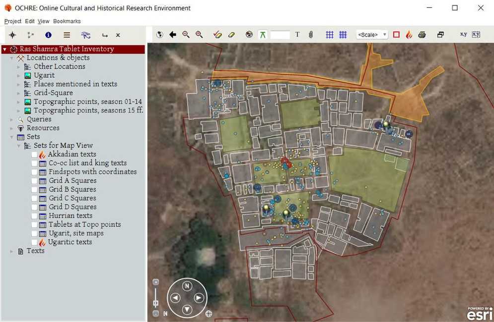
Display layers of geographic information
Display layers of geographic information from disparate data sources and of many data types together in one map canvas. Layering of maps, georeferenced drawings (“top plans”), drone photographs, and scans of published legacy material, along with controls to adjust color and transparency, let researchers compare last week's progress to this week's, or compare a prior excavation's result with their own.
Styles, symbols, renderers
Uniquely render your data based on various data values. Options for styles, symbols, renderers, grids, and labels allow creative visualizations, bringing ancient ruins to life as palaces or temples, courtyards or tombs, situated in time and space.
App details
For archaeologists, the importance of data capture and onsite field recording cannot be overstated. Walls and surfaces once excavated, and artifacts once collected from the site, are well and truly gone from their original contexts. A particular challenge, though, is that so much of the excavation data has spatial characteristics: locations of sites, coordinates of find-spots, points representing elevation data, shapes and outlines of units of excavation, 3D reconstructions of objects and structures, and so on. Using the ArcGIS Maps SDK for Java to integrate GIS features within a comprehensive, item-based core database like the Online Cultural and Historical Research Environment (OCHRE), gives archaeologists a vital and powerful means of revolutionizing their digital methods on the ground. GIS features in OCHRE, made possible by the Esri SDK, allow for data collection and visualization strategies that result in more accurate, all-inclusive data capture. OCHRE, as a full-featured, Java-based, graph database system, already had a solid data management framework. But Geospatially-Enabled OCHRE (GEO), thanks to the ArcGIS Maps SDK for Java, has the means to put everything in its place—geographically and spatially—within a uniquely-integrated computational environment, giving today's archaeologists a compelling and comprehensive perspective on the past.