Project a point from one coordinate system to another using a specific transformation step.
Use case
While the geometry engine supports automatic transformation of geometry between coordinate systems, some coordinate system pairs have specific transformations defined for additional accuracy within certain areas. For example, your organization could work in a local state plane using the NAD83 or NAD83 (HARN) datums while collecting data in the standard WGS 1984 datum. Your organization can define a specific transformation step to use to ensure precise, reliable data collection.
How to use the sample
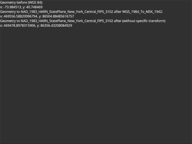
View the values for: unprojected point, projected with the GeometryEngine default, and projected with a specific transformation step.
How it works
- Get a locations coordinates in WGS 84.
- Use the geometry engine to project the point without specifying a transformation step. Display the result for comparison.
- Use the geometry engine to project the point, this time specifying a transformation step. Display the result.
- Compare the results to see how a specific transformation step can result in a slightly different (and potentially more accurate) result.
Relevant API
- GeographicTransformation
- GeographicTransformationStep
About the data
To avoid the need to project from mercator coordinates to WGS 84, this sample uses World Basemaps (WGS84) from ArcGIS Online’s living atlas.
Additional information
See Spatial references in the ArcGIS Maps SDK for .NET guide for more information about geographic coordinate systems, geographic transformations, and projected coordinate systems.
Tags
coordinate system, geographic, project, projection, transform, transformation, transformation step
Sample code
// Copyright 2022 Esri.//// Licensed under the Apache License, Version 2.0 (the "License"); you may not use this file except in compliance with the License.// You may obtain a copy of the License at: http://www.apache.org/licenses/LICENSE-2.0//// Unless required by applicable law or agreed to in writing, software distributed under the License is distributed on an// "AS IS" BASIS, WITHOUT WARRANTIES OR CONDITIONS OF ANY KIND, either express or implied. See the License for the specific// language governing permissions and limitations under the License.
using Esri.ArcGISRuntime.Geometry;
namespace ArcGIS.Samples.ProjectWithSpecificTransformation{    [ArcGIS.Samples.Shared.Attributes.Sample(        name: "Project with specific transformation",        category: "Geometry",        description: "Project a point from one coordinate system to another using a specific transformation step.",        instructions: "View the values for: unprojected point, projected with the GeometryEngine default, and projected with a specific transformation step.",        tags: new[] { "coordinate system", "geographic", "project", "projection", "transform", "transformation", "transformation step" })]    public partial class ProjectWithSpecificTransformation : ContentPage    {        public ProjectWithSpecificTransformation()        {            InitializeComponent();
            // Create the UI, setup the control references and execute initialization            Initialize();        }
        private void Initialize()        {            // Create a point geometry in NYC in WGS84            MapPoint startingPoint = new MapPoint(-73.984513, 40.748469, SpatialReferences.Wgs84);
            // Update the UI with the initial coordinates            BeforeLabel.Text = $"x: {startingPoint.X}, y: {startingPoint.Y}";
            // Create a geographic transformation step for transform WKID 108055, WGS_1984_To_MSK_1942            GeographicTransformationStep geoStep = new GeographicTransformationStep(108055);
            // Create the transformation            GeographicTransformation geoTransform = new GeographicTransformation(geoStep);
            // Project to a coordinate system used in New York, NAD_1983_HARN_StatePlane_New_York_Central_FIPS_3102            MapPoint afterPoint = (MapPoint)startingPoint.Project(SpatialReference.Create(2829), geoTransform);
            // Update the UI with the projected coordinates            AfterLabel.Text = $"x: {afterPoint.X}, y: {afterPoint.Y}";
            // Perform the same projection without specified transformation            MapPoint unspecifiedTransformPoint = (MapPoint)startingPoint.Project(SpatialReference.Create(2829));
// Update the UI with the projection done without specific transform for comparison purposes NonSpecificLabel.Text = $"x: {unspecifiedTransformPoint.X}, y: {unspecifiedTransformPoint.Y}"; } }}<?xml version="1.0" encoding="utf-8" ?><ContentPage x:Class="ArcGIS.Samples.ProjectWithSpecificTransformation.ProjectWithSpecificTransformation" xmlns="http://schemas.microsoft.com/dotnet/2021/maui" xmlns:x="http://schemas.microsoft.com/winfx/2009/xaml"> <StackLayout> <Label Text="Geometry before (WGS 84):" /> <Label x:Name="BeforeLabel" /> <Label Text="Geometry to NAD_1983_HARN_StatePlane_New_York_Central_FIPS_3102 after WGS_1984_To_MSK_1942:" /> <Label x:Name="AfterLabel" /> <Label Text="Geometry to NAD_1983_HARN_StatePlane_New_York_Central_FIPS_3102 after (without specific transform)" /> <Label x:Name="NonSpecificLabel" /> </StackLayout></ContentPage>