Query data from an OGC API feature service using CQL filters.
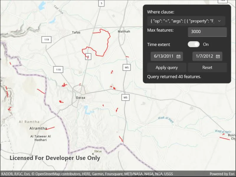
Use case
CQL (Common Query Language) is an OGC-created query language used to query for subsets of features. Use CQL filters to narrow geometry results from an OGC feature table.
How to use the sample
Enter a CQL query. Press the “Apply query” button to see the query applied to the OGC API features shown on the map.
How it works
- Create an
OgcFeatureCollectionTableobject using a URL to an OGC API feature service and a collection ID. - Create a
QueryParametersobject. - Set the
QueryParameters.WhereClauseproperty. - Set the
QueryParameters.MaxFeaturesproperty. - Create
Datetimeobjects for the start time and end time being queried. - Create a
TimeExtentobject using the start and endDatetimeobjects. Set theQueryParameters.TimeExtentproperty - Populate the
OgcFeatureCollectionTableusingPopulateFromServiceAsync()with the customQueryParameterscreated in the previous steps. - Use
MapView.SetViewpointGeometryAsync()with theOgcFeatureCollectionTable.Extentto view the newly-queried features.
Relevant API
- OgcFeatureCollectionTable
- QueryParameters
- TimeExtent
About the data
The Daraa, Syria test data is OpenStreetMap data converted to the Topographic Data Store schema of NGA.
Additional information
See the OGC API website for more information on the OGC API family of standards. See the CQL documentation to learn more about the common query language.
Tags
browse, catalog, common query language, CQL, feature table, filter, OGC, OGC API, query, service, web
Sample code
// Copyright 2022 Esri.//// Licensed under the Apache License, Version 2.0 (the "License"); you may not use this file except in compliance with the License.// You may obtain a copy of the License at: http://www.apache.org/licenses/LICENSE-2.0//// Unless required by applicable law or agreed to in writing, software distributed under the License is distributed on an// "AS IS" BASIS, WITHOUT WARRANTIES OR CONDITIONS OF ANY KIND, either express or implied. See the License for the specific// language governing permissions and limitations under the License.
using Esri.ArcGISRuntime.Data;using Esri.ArcGISRuntime.Geometry;using Esri.ArcGISRuntime.Mapping;using Esri.ArcGISRuntime.Symbology;
using Color = System.Drawing.Color;
namespace ArcGIS.Samples.QueryCQLFilters{    [ArcGIS.Samples.Shared.Attributes.Sample(        name: "Query with CQL filters",        category: "Layers",        description: "Query data from an OGC API feature service using CQL filters.",        instructions: "Enter a CQL query. Press the \"Apply query\" button to see the query applied to the OGC API features shown on the map.",        tags: new[] { "CQL", "OGC", "OGC API", "browse", "catalog", "common query language", "feature table", "filter", "query", "service", "web" })]    public partial class QueryCQLFilters : ContentPage    {        private List<string> DefaultWhereClause = new List<string>        {            // Sample Query 1: Query for features with an F_CODE attribute property of "AP010".            "{ \"op\": \"=\", \"args\": [ { \"property\": \"F_CODE\" }, \"AP010\" ] }", // cql2-json query
            // Sample Query 2: Query for features with an F_CODE attribute property similar to "AQ".            "F_CODE LIKE 'AQ%'", // cql-text query
            // Sample Query 3: use cql2-json to combine "before" and "eq" operators with the logical "and" operator.           "{\"op\": \"and\", \"args\":[{ \"op\": \"=\", \"args\":[{ \"property\" : \"F_CODE\" }, \"AP010\"]}, { \"op\": \"t_before\", \"args\":[{ \"property\" : \"ZI001_SDV\"},\"2013-01-01\"]}]}"        };
        // Hold a reference to the OGC feature collection table.        private OgcFeatureCollectionTable _featureTable;
        // Constants for the service URL and collection id.        private const string ServiceUrl = "https://demo.ldproxy.net/daraa";
        // Note that the service defines the collection id which can be accessed via OgcFeatureCollectionInfo.CollectionId.        private const string CollectionId = "TransportationGroundCrv";
        public QueryCQLFilters()        {            InitializeComponent();            _ = Initialize();        }
        private async Task Initialize()        {            // Populate the UI.            WhereClausePicker.ItemsSource = DefaultWhereClause;            MaxFeaturesBox.Text = "3000";            StartDatePicker.Date = new DateTime(2011, 6, 13);            EndDatePicker.Date = new DateTime(2012, 1, 7);
            // Create the map with topographic basemap.            MyMapView.Map = new Map(BasemapStyle.ArcGISTopographic);
            try            {                LoadingProgressBar.IsVisible = true;
                // Create the feature table from URI and collection id.                _featureTable = new OgcFeatureCollectionTable(new Uri(ServiceUrl), CollectionId);
                // Set the feature request mode to manual (only manual is currently supported).                // In this mode, you must manually populate the table - panning and zooming won't request features automatically.                _featureTable.FeatureRequestMode = FeatureRequestMode.ManualCache;
                // Load the table.                await _featureTable.LoadAsync();
                // Populate the OGC feature collection table.                QueryParameters queryParamaters = new QueryParameters();                queryParamaters.MaxFeatures = 3000;                await _featureTable.PopulateFromServiceAsync(queryParamaters, false, null);
                // Create a feature layer from the OGC feature collection                // table to visualize the OAFeat features.                FeatureLayer ogcFeatureLayer = new FeatureLayer(_featureTable);
                // Set a renderer for the layer.                ogcFeatureLayer.Renderer = new SimpleRenderer(new SimpleLineSymbol(SimpleLineSymbolStyle.Solid, Color.Red, 1.5));
                // Add the layer to the map.                MyMapView.Map.OperationalLayers.Add(ogcFeatureLayer);
                // Zoom to the extent of the feature layer/table.                Envelope tableExtent = _featureTable.Extent;                if (tableExtent != null && !tableExtent.IsEmpty)                {                    await MyMapView.SetViewpointGeometryAsync(tableExtent, 20);                }            }            catch (Exception ex)            {                await Application.Current.Windows[0].Page.DisplayAlert("Error", ex.Message, "OK");            }            finally            {                // Update the UI.                LoadingProgressBar.IsVisible = false;            }        }
        public QueryParameters CreateQueryParameters()        {            // Create new query parameters.            var queryParameters = new QueryParameters();
            // Assign the where clause if one is provided.            if (WhereClausePicker.SelectedItem is string selectedClause) queryParameters.WhereClause = selectedClause;
            // Set the MaxFeatures property to MaxFeaturesBox content.            if (int.TryParse(MaxFeaturesBox.Text, out int parsedMaxFeatures))                queryParameters.MaxFeatures = parsedMaxFeatures;
            // Set user date times if provided.            if (DateSwitch.IsToggled == true)            {                DateTime startDate = (StartDatePicker.Date is DateTime userStart) ? userStart : DateTime.MinValue;                DateTime endDate = (EndDatePicker.Date is DateTime userEnd) ? userEnd : new DateTime(9999, 12, 31);
                // Use the newly created startDate and endDate to create the TimeExtent.                queryParameters.TimeExtent = new Esri.ArcGISRuntime.TimeExtent(startDate, endDate);            }
            return queryParameters;        }
        private async void ApplyQuery_Pressed(object sender, EventArgs e)        {            if (_featureTable.LoadStatus != Esri.ArcGISRuntime.LoadStatus.Loaded)            {                return;            }
            try            {                LoadingProgressBar.IsVisible = true;
                // Set queryParameters to the user's input                var queryParameters = CreateQueryParameters();
                // Populate the table with the query, clearing the exist content of the table.                // Setting outFields to null requests all fields.                var result = await _featureTable.PopulateFromServiceAsync(queryParameters, true, outFields: null);
                // Report the number of returned features by the query                NumberOfReturnedFeatures.Text = $"Query returned {result.Count()} features.";
                // Zoom to the extent of the returned features.                Envelope tableExtent = GeometryEngine.CombineExtents(result.Select(feature => feature.Geometry));                if (tableExtent != null && !tableExtent.IsEmpty)                {                    await MyMapView.SetViewpointGeometryAsync(tableExtent, 20);                }            }            catch (Exception ex)            {                await Application.Current.Windows[0].Page.DisplayAlert("Error", ex.Message, "OK");            }            finally            {                // Update the UI.                LoadingProgressBar.IsVisible = false;            }        }
        private void ResetQuery_Pressed(object sender, EventArgs e)        {            WhereClausePicker.SelectedItem = null;            MaxFeaturesBox.Text = "3000";            DateSwitch.IsToggled = true;            StartDatePicker.Date = new DateTime(2011, 6, 13);            EndDatePicker.Date = new DateTime(2012, 1, 7);        }
private void DateSwitch_Toggled(object sender, ToggledEventArgs e) { if (StartDatePicker != null && EndDatePicker != null) { StartDatePicker.IsEnabled = EndDatePicker.IsEnabled = e.Value; } } }}<ContentPage x:Class="ArcGIS.Samples.QueryCQLFilters.QueryCQLFilters" xmlns="http://schemas.microsoft.com/dotnet/2021/maui" xmlns:x="http://schemas.microsoft.com/winfx/2009/xaml" xmlns:esriUI="clr-namespace:Esri.ArcGISRuntime.Maui;assembly=Esri.ArcGISRuntime.Maui" xmlns:resources="clr-namespace:ArcGIS.Resources"> <Grid Style="{DynamicResource EsriSampleContainer}"> <esriUI:MapView x:Name="MyMapView" Style="{DynamicResource EsriSampleGeoView}" /> <Border Style="{DynamicResource EsriSampleControlPanel}"> <Grid Padding="5" ColumnDefinitions="*,*" ColumnSpacing="5" RowDefinitions="auto,auto,auto,auto,auto,auto" RowSpacing="5"> <Label Grid.Row="0" Grid.Column="0" Text="Where clause:" VerticalOptions="Center" /> <Picker x:Name="WhereClausePicker" Grid.Row="0" Grid.Column="1" /> <Label Grid.Row="1" Grid.Column="0" Text="Max features:" /> <Entry x:Name="MaxFeaturesBox" Grid.Row="1" Grid.Column="1" Keyboard="Numeric" /> <Label Grid.Row="2" Grid.Column="0" Text="Time extent" VerticalOptions="Center" /> <Switch x:Name="DateSwitch" Grid.Row="2" Grid.Column="1" HorizontalOptions="Start" IsToggled="True" Toggled="DateSwitch_Toggled" /> <DatePicker x:Name="StartDatePicker" Grid.Row="3" Grid.Column="0" HorizontalOptions="Center" /> <DatePicker x:Name="EndDatePicker" Grid.Row="3" Grid.Column="1" HorizontalOptions="Center" /> <Button x:Name="ApplyQuery" Grid.Row="4" Grid.Column="0" Pressed="ApplyQuery_Pressed" Text="Apply query" /> <Button x:Name="ResetQuery" Grid.Row="4" Grid.Column="1" Pressed="ResetQuery_Pressed" Text="Reset" /> <Label x:Name="NumberOfReturnedFeatures" Grid.Row="5" Grid.Column="0" Grid.ColumnSpan="2" /> </Grid> </Border> <ActivityIndicator x:Name="LoadingProgressBar" Grid.RowSpan="2" Grid.ColumnSpan="2" HorizontalOptions="Center" IsRunning="True" VerticalOptions="Center" /> </Grid></ContentPage>