Create and share a mobile geodatabase.
Use case
A mobile geodatabase is a collection of various types of GIS datasets contained in a single file (.geodatabase) on disk that can store, query, and manage spatial and nonspatial data. Mobile geodatabases are stored in a SQLite database and can contain up to 2 TB of portable data. Users can create, edit and share mobile geodatabases across ArcGIS Pro, ArcGIS Runtime, or any SQL software. These mobile geodatabases support both viewing and editing and enable new offline editing workflows that don’t require a feature service.
For example, a user would like to track the location of their device at various intervals to generate a heat map of the most visited locations. The user can add each location as a feature to a table and generate a mobile geodatabase. The user can then instantly share the mobile geodatabase to ArcGIS Pro to generate a heat map using the recorded locations stored as a geodatabase feature table.
How to use the sample
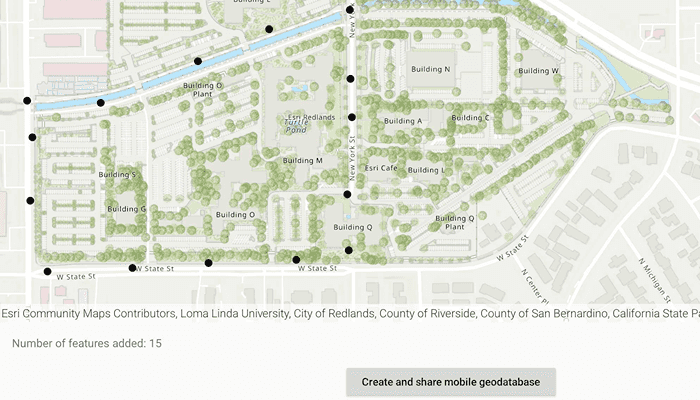
Tap on the map to add a feature symbolizing the user's location. Tap "View table" to view the contents of the geodatabase feature table. Once you have added the location points to the map, click on "Create and share mobile geodatabase" to retrieve the .geodatabase file which can then be imported into ArcGIS Pro or opened in an ArcGIS Runtime application.
How it works
- Create the
Geodatabasefrom the mobile geodatabase location on file. - Create a new
TableDescriptionand add the list ofFieldDescriptions to the table description. - Create a
GeodatabaseFeatureTablein the geodatabase from theTableDescriptionusingGeodatabase.createTableAsync(). - Create a feature on the selected map point using
GeodatabaseFeatureTable.createFeature(featureAttributes, mapPoint). - Add the feature to the table using
GeodatabaseFeatureTable.addFeatureAsync(feature). - Each feature added to the
GeodatabaseFeatureTableis committed to the mobile geodatabase file. - Close the mobile geodatabase to safely share the ".geodatabase" file using
Geodatabase.close()
Relevant API
- ArcGISFeature
- FeatureLayer
- FeatureTable
- FieldDescription
- Geodatabase
- GeodatabaseFeatureTable
- TableDescription
Additional information
Learn more about mobile geodatabases and how to utilize them on the ArcGIS Pro documentation page. The following mobile geodatabase behaviors are supported in ArcGIS Runtime: annotation, attachments, attribute rules, contingent values, dimensions, domains, feature-linked annotation, subtypes, utility network and relationship classes.
Learn more about the types of fields supported with mobile geodatabases on the ArcGIS Pro documentation page.
Tags
arcgis pro, database, feature, feature table, geodatabase, mobile geodatabase, sqlite
Sample Code
/* Copyright 2022 Esri
*
* Licensed under the Apache License, Version 2.0 (the "License");
* you may not use this file except in compliance with the License.
* You may obtain a copy of the License at
*
* http://www.apache.org/licenses/LICENSE-2.0
*
* Unless required by applicable law or agreed to in writing, software
* distributed under the License is distributed on an "AS IS" BASIS,
* WITHOUT WARRANTIES OR CONDITIONS OF ANY KIND, either express or implied.
* See the License for the specific language governing permissions and
* limitations under the License.
*
*/
package com.esri.arcgisruntime.sample.createmobilegeodatabase
import android.app.Dialog
import android.content.Intent
import android.os.Bundle
import android.util.Log
import android.view.MotionEvent
import android.widget.Button
import android.widget.TextView
import android.widget.Toast
import androidx.appcompat.app.AppCompatActivity
import androidx.core.content.FileProvider
import com.esri.arcgisruntime.ArcGISRuntimeEnvironment
import com.esri.arcgisruntime.concurrent.ListenableFuture
import com.esri.arcgisruntime.data.*
import com.esri.arcgisruntime.geometry.GeometryType
import com.esri.arcgisruntime.geometry.Point
import com.esri.arcgisruntime.geometry.SpatialReferences
import com.esri.arcgisruntime.layers.FeatureLayer
import com.esri.arcgisruntime.loadable.LoadStatus
import com.esri.arcgisruntime.mapping.ArcGISMap
import com.esri.arcgisruntime.mapping.BasemapStyle
import com.esri.arcgisruntime.mapping.Viewpoint
import com.esri.arcgisruntime.mapping.view.DefaultMapViewOnTouchListener
import com.esri.arcgisruntime.mapping.view.MapView
import com.esri.arcgisruntime.sample.createmobilegeodatabase.databinding.ActivityMainBinding
import com.esri.arcgisruntime.sample.createmobilegeodatabase.databinding.TableLayoutBinding
import com.esri.arcgisruntime.sample.createmobilegeodatabase.databinding.TableRowBinding
import java.io.File
import java.util.*
class MainActivity : AppCompatActivity() {
private val TAG = MainActivity::class.java.simpleName
private val activityMainBinding by lazy {
ActivityMainBinding.inflate(layoutInflater)
}
private val mapView: MapView by lazy {
activityMainBinding.mapView
}
private val createButton: Button by lazy {
activityMainBinding.createButton
}
private val viewTableButton: Button by lazy {
activityMainBinding.viewTableButton
}
private val featureCount: TextView by lazy {
activityMainBinding.featureCount
}
// feature table created using mobile geodatabase and added to the MapView
private var featureTable: GeodatabaseFeatureTable? = null
// mobile geodatabase used to create and store the feature attributes (LocationHistory.geodatabase)
private var geodatabase: Geodatabase? = null
override fun onCreate(savedInstanceState: Bundle?) {
super.onCreate(savedInstanceState)
setContentView(activityMainBinding.root)
// authentication with an API key or named user is
// required to access basemaps and other location services
ArcGISRuntimeEnvironment.setApiKey(BuildConfig.API_KEY)
mapView.apply {
// create a map with a topographic basemap and set the map to the mapview
map = ArcGISMap(BasemapStyle.ARCGIS_TOPOGRAPHIC)
setViewpoint(Viewpoint(34.056295, -117.195800, 10000.0))
// listen for single taps on the map
onTouchListener =
object : DefaultMapViewOnTouchListener(this@MainActivity, mapView) {
override fun onSingleTapConfirmed(motionEvent: MotionEvent?): Boolean {
motionEvent?.let { event ->
// get the map point from the screen point
val mapPoint = mapView.screenToLocation(
android.graphics.Point(
event.x.toInt(),
event.y.toInt()
)
)
// create a point from where the user clicked
addFeature(mapPoint)
}
return super.onSingleTapConfirmed(motionEvent)
}
}
}
viewTableButton.setOnClickListener {
// displays table dialog with the values in the feature table
displayTable()
}
// opens a share-sheet with the "LocationHistory.geodatabase" file
createButton.setOnClickListener {
try {
// close the mobile geodatabase before sharing
geodatabase?.close()
// get the URI of the geodatabase file using FileProvider
val geodatabaseURI = FileProvider.getUriForFile(
this, getString(R.string.file_provider_package), File(
geodatabase?.path.toString()
)
)
// set up the sharing intent with the geodatabase URI
val geodatabaseIntent = Intent(Intent.ACTION_SEND).apply {
type = "*/*"
putExtra(Intent.EXTRA_STREAM, geodatabaseURI)
}
// open the Android share sheet
startActivity(geodatabaseIntent)
} catch (e: Exception) {
showError("Error sharing file: ${e.message}")
}
}
}
/**
* Create and load a new geodatabase file with TableDescription fields
*/
private fun createGeodatabase() {
// define the path and name of the geodatabase file
// note: the path defined must be non-empty, available,
// allow read/write access, and end in ".geodatabase"
val file = File(getExternalFilesDir(null)?.path + "/LocationHistory.geodatabase")
if (file.exists()) {
file.delete()
}
// close the existing geodatabase
geodatabase?.close()
// create a geodatabase file at the file path
val geodatabaseFuture = Geodatabase.createAsync(file.path)
geodatabaseFuture.addDoneListener {
// get the instance of the mobile geodatabase
geodatabase = geodatabaseFuture.get()
// construct a table description which stores features as points on map
val tableDescription =
TableDescription(
"LocationHistory",
SpatialReferences.getWgs84(),
GeometryType.POINT
)
// set up the fields to the table,
// Field.Type.OID is the primary key of the SQLite table
// Field.Type.DATE is a date column used to store a Calendar date
// FieldDescriptions can be a SHORT, INTEGER, GUID, FLOAT, DOUBLE, DATE, TEXT, OID, GLOBALID, BLOB, GEOMETRY, RASTER, or XML.
tableDescription.fieldDescriptions.addAll(
listOf(
FieldDescription("oid", Field.Type.OID),
FieldDescription("collection_timestamp", Field.Type.DATE)
)
)
// set any properties not needed to false
tableDescription.apply {
setHasAttachments(false)
setHasM(false)
setHasZ(false)
}
// add a new table to the geodatabase by creating one from the tableDescription
val tableFuture = geodatabase?.createTableAsync(tableDescription)
if (tableFuture != null) {
setupMapFromGeodatabase(tableFuture)
} else {
showError("Error adding FieldDescriptions to the mobile geodatabase")
}
}
}
/**
* Set up the MapView to display the Feature layer
* using the loaded [tableFuture] GeodatabaseFeatureTable
*/
private fun setupMapFromGeodatabase(tableFuture: ListenableFuture<GeodatabaseFeatureTable>) {
tableFuture.addDoneListener {
// get the result of the loaded "LocationHistory" table
featureTable = tableFuture.get()
// create a feature layer for the map using the GeodatabaseFeatureTable
val featureLayer = FeatureLayer(featureTable)
mapView.map.operationalLayers.add(featureLayer)
// display the current count of features in the FeatureTable
featureCount.text = "Number of features added: ${featureTable?.totalFeatureCount}"
}
}
/**
* Create a feature with attributes on map click and it to the [featureTable]
* Also, updates the TotalFeatureCount on the screen
*/
private fun addFeature(mapPoint: Point) {
// set up the feature attributes
val featureAttributes = mutableMapOf<String, Any>()
featureAttributes["collection_timestamp"] = Calendar.getInstance()
// create a new feature at the mapPoint
val feature = featureTable?.createFeature(featureAttributes, mapPoint)
// add the feature to the feature table
val addFeatureFuture = featureTable?.addFeatureAsync(feature)
addFeatureFuture?.addDoneListener {
try {
// if feature wasn't added successfully "addFeatureFuture.get()" will throw an exception
addFeatureFuture.get()
// feature added successfully, update count
featureCount.text = "Number of features added: ${featureTable?.totalFeatureCount}"
// enable table button since at least 1 feature loaded on the GeodatabaseFeatureTable
viewTableButton.isEnabled = true
} catch (e: Exception) {
showError(e.message.toString())
}
}
}
/**
* Displays a dialog with the table of features
* added to the GeodatabaseFeatureTable [featureTable]
*/
private fun displayTable() {
// query all the features loaded to the table
val queryResultFuture = featureTable?.queryFeaturesAsync(QueryParameters())
queryResultFuture?.addDoneListener {
val queryResults = queryResultFuture.get()
// inflate the table layout
val tableLayoutBinding = TableLayoutBinding.inflate(layoutInflater)
// set up a dialog to be displayed
Dialog(this).apply {
setContentView(tableLayoutBinding.root)
setCancelable(true)
// grab the instance of the TableLayout
val table = tableLayoutBinding.tableLayout
// iterate through each feature to add to the TableLayout
queryResults.forEach { feature ->
// prepare the table row
val tableRowBinding = TableRowBinding.inflate(layoutInflater).apply {
oid.text = feature.attributes["oid"].toString()
collectionTimestamp.text = (feature.attributes["collection_timestamp"] as Calendar).time.toString()
}
// add the row to the TableLayout
table.addView(tableRowBinding.root)
}
}.show()
}
}
/**
* Called on app launch or when Android share sheet is closed
*/
private fun resetMap() {
mapView.map.addDoneLoadingListener {
if (mapView.map.loadStatus == LoadStatus.LOADED) {
// clear any feature layers displayed on the map
mapView.map.operationalLayers.clear()
// disable the button since no features are displayed
viewTableButton.isEnabled = false
// create a new geodatabase file to add features into the feature table
createGeodatabase()
} else {
showError("Error loading MapView: ${mapView.map.loadError.message}")
}
}
}
private fun showError(message: String?) {
Toast.makeText(this, message, Toast.LENGTH_SHORT).show()
Log.e(TAG, message.toString())
}
override fun onPause() {
mapView.pause()
super.onPause()
}
override fun onResume() {
super.onResume()
mapView.resume()
resetMap()
}
override fun onDestroy() {
mapView.dispose()
super.onDestroy()
}
}