Extrude features based on their attributes.
Use case
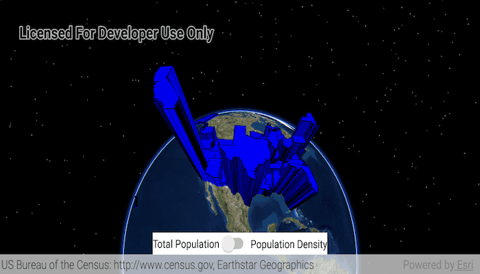
Extrusion is the process of stretching a flat, 2D shape vertically to create a 3D object in a scene. For example, you can extrude building polygons by a height value to create three-dimensional building shapes.
How to use the sample
Tap the toggle to switch between using population density and total population for extrusion. Higher extrusion directly corresponds to higher attribute values.
How it works
- Create a
ServiceFeatureTablefrom a URL. - Create a feature layer from the service feature table.
- Make sure to set the rendering mode to dynamic,
statesFeatureLayer.renderingMode = RenderingMode.DYNAMIC.
- Make sure to set the rendering mode to dynamic,
- Apply a
SimpleRendererto the feature layer. - Set the
ExtrusionModeof the renderer withrenderer.sceneProperties.extrusionMode = SceneProperties.ExtrusionMode.BASE_HEIGHT. - Set the extrusion expression of the renderer with
renderer.sceneProperties.extrusionExpression = "[POP2007]/ 10".
Relevant API
- FeatureLayer
- Renderer.SceneProperties
- ServiceFeatureTable
- SimpleRenderer
Tags
3D, extrude, extrusion, extrusion expression, height, renderer, scene
Sample Code
MainActivity.kt
/* Copyright 2017 Esri
*
* Licensed under the Apache License, Version 2.0 (the "License");
* you may not use this file except in compliance with the License.
* You may obtain a copy of the License at
*
* http://www.apache.org/licenses/LICENSE-2.0
*
* Unless required by applicable law or agreed to in writing, software
* distributed under the License is distributed on an "AS IS" BASIS,
* WITHOUT WARRANTIES OR CONDITIONS OF ANY KIND, either express or implied.
* See the License for the specific language governing permissions and
* limitations under the License.
*
*/
package com.esri.arcgisruntime.sample.featurelayerextrusion
import android.graphics.Color
import android.os.Bundle
import android.widget.Button
import androidx.appcompat.app.AppCompatActivity
import com.esri.arcgisruntime.ArcGISRuntimeEnvironment
import com.esri.arcgisruntime.data.ServiceFeatureTable
import com.esri.arcgisruntime.geometry.Point
import com.esri.arcgisruntime.geometry.SpatialReferences
import com.esri.arcgisruntime.layers.FeatureLayer
import com.esri.arcgisruntime.mapping.ArcGISScene
import com.esri.arcgisruntime.mapping.BasemapStyle
import com.esri.arcgisruntime.mapping.view.Camera
import com.esri.arcgisruntime.mapping.view.OrbitLocationCameraController
import com.esri.arcgisruntime.mapping.view.SceneView
import com.esri.arcgisruntime.symbology.Renderer
import com.esri.arcgisruntime.symbology.SimpleFillSymbol
import com.esri.arcgisruntime.symbology.SimpleLineSymbol
import com.esri.arcgisruntime.symbology.SimpleRenderer
import com.esri.arcgisruntime.sample.featurelayerextrusion.databinding.ActivityMainBinding
class MainActivity : AppCompatActivity() {
// set flag for showing total population or population density
private var showTotalPopulation = true
private val activityMainBinding by lazy {
ActivityMainBinding.inflate(layoutInflater)
}
private val sceneView: SceneView by lazy {
activityMainBinding.sceneView
}
private val toggleButton: Button by lazy {
activityMainBinding.toggleButton
}
override fun onCreate(savedInstanceState: Bundle?) {
super.onCreate(savedInstanceState)
setContentView(activityMainBinding.root)
// authentication with an API key or named user is required to access basemaps and other
// location services
ArcGISRuntimeEnvironment.setApiKey(BuildConfig.API_KEY)
// get us census data as a service feature table
val statesServiceFeatureTable =
ServiceFeatureTable(resources.getString(R.string.us_census_feature_service))
// add the service feature table to a feature layer
val statesFeatureLayer = FeatureLayer(statesServiceFeatureTable)
// set the feature layer to render dynamically to allow extrusion
statesFeatureLayer.renderingMode = FeatureLayer.RenderingMode.DYNAMIC
// create a scene and add it to the scene view
val scene = ArcGISScene(BasemapStyle.ARCGIS_IMAGERY)
sceneView.scene = scene
// add the feature layer to the scene
scene.operationalLayers.add(statesFeatureLayer)
// define line and fill symbols for a simple renderer
val lineSymbol = SimpleLineSymbol(SimpleLineSymbol.Style.SOLID, Color.BLACK, 1.0f)
val fillSymbol = SimpleFillSymbol(SimpleFillSymbol.Style.SOLID, Color.BLUE, lineSymbol)
val renderer = SimpleRenderer(fillSymbol)
// set renderer extrusion mode to base height, which includes base height of each vertex in calculating z values
renderer.sceneProperties.extrusionMode = Renderer.SceneProperties.ExtrusionMode.BASE_HEIGHT
// set the simple renderer to the feature layer
statesFeatureLayer.renderer = renderer
// define a look at point for the camera at geographical center of the continental US
val lookAtPoint = Point(-10974490.0, 4814376.0, 0.0, SpatialReferences.getWebMercator())
// add a camera and set it to orbit the look at point
val camera = Camera(lookAtPoint, 20000000.0, 0.0, 55.0, 0.0)
val orbitCamera = OrbitLocationCameraController(lookAtPoint, 20000000.0)
sceneView.cameraController = orbitCamera
sceneView.setViewpointCamera(camera)
// set button listener
toggleButton.setOnClickListener {
if (showTotalPopulation) {
// divide total population by 10 to make data legible
renderer.sceneProperties.extrusionExpression = "[POP2007] / 10"
// change text of button to total pop
toggleButton.text = resources.getString(R.string.total_pop)
showTotalPopulation = false
} else {
// multiple population density by 5000 to make data legible
renderer.sceneProperties.extrusionExpression = "[POP07_SQMI] * 5000"
// change text of button to pop density
toggleButton.text = resources.getString(R.string.density_pop)
showTotalPopulation = true
}
}
// click to set initial state
toggleButton.performClick()
}
override fun onPause() {
super.onPause()
sceneView.pause()
}
override fun onResume() {
super.onResume()
sceneView.resume()
}
override fun onDestroy() {
super.onDestroy()
sceneView.dispose()
}
}