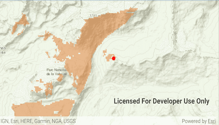
Calculate a viewshed using a geoprocessing service, in this case showing what parts of a landscape are visible from points on mountainous terrain.
Use case
A viewshed is used to highlight what is visible from a given point. A viewshed could be created to show what a hiker might be able to see from a given point at the top of a mountain. Equally, a viewshed could also be created from a point representing the maximum height of a proposed wind turbine to see from what areas the turbine would be visible.
How to use the sample
Tap the map to see all areas visible from that point within a 15km radius. Tapping on an elevated area will highlight a larger part of the surrounding landscape. It may take a few seconds for the task to run and send back the results.
How it works
- Create a
GeoprocessingTaskobject with the URL set to a geoprocessing service endpoint. - Create a
FeatureCollectionTableobject and add a newFeatureobject whose geometry is the viewshed's observerPoint. - Make a
GeoprocessingParametersobject passing in the observer point. - Use the geoprocessing task to create a
GeoprocessingJobobject with the parameters. - Start the job and wait for it to complete and return a
GeoprocessingResultobject. - Get the resulting
GeoprocessingFeaturesobject. - Iterate through the viewshed features to use their geometry or display the geometry in a new
Graphicobject.
Relevant API
- FeatureCollectionTable
- GeoprocessingFeatures
- GeoprocessingJob
- GeoprocessingParameters
- GeoprocessingResult
- GeoprocessingTask
Tags
analysis, geoprocessing, heat map, viewshed
Sample Code
/* Copyright 2020 Esri
*
* Licensed under the Apache License, Version 2.0 (the "License")
* you may not use this file except in compliance with the License.
* You may obtain a copy of the License at
*
* http://www.apache.org/licenses/LICENSE-2.0
*
* Unless required by applicable law or agreed to in writing, software
* distributed under the License is distributed on an "AS IS" BASIS,
* WITHOUT WARRANTIES OR CONDITIONS OF ANY KIND, either express or implied.
* See the License for the specific language governing permissions and
* limitations under the License.
*
*/
package com.esri.arcgisruntime.sample.viewshedgeoprocessing
import android.graphics.Color
import android.os.Bundle
import android.util.Log
import android.view.MotionEvent
import android.view.View
import android.widget.Toast
import androidx.appcompat.app.AppCompatActivity
import com.esri.arcgisruntime.ArcGISRuntimeEnvironment
import com.esri.arcgisruntime.concurrent.Job
import com.esri.arcgisruntime.concurrent.ListenableFuture
import com.esri.arcgisruntime.data.FeatureCollectionTable
import com.esri.arcgisruntime.data.Field
import com.esri.arcgisruntime.geometry.GeometryType
import com.esri.arcgisruntime.geometry.Point
import com.esri.arcgisruntime.loadable.LoadStatus
import com.esri.arcgisruntime.mapping.ArcGISMap
import com.esri.arcgisruntime.mapping.BasemapStyle
import com.esri.arcgisruntime.mapping.Viewpoint
import com.esri.arcgisruntime.mapping.view.DefaultMapViewOnTouchListener
import com.esri.arcgisruntime.mapping.view.Graphic
import com.esri.arcgisruntime.mapping.view.GraphicsOverlay
import com.esri.arcgisruntime.mapping.view.MapView
import com.esri.arcgisruntime.sample.viewshedgeoprocessing.databinding.ActivityMainBinding
import com.esri.arcgisruntime.symbology.SimpleFillSymbol
import com.esri.arcgisruntime.symbology.SimpleMarkerSymbol
import com.esri.arcgisruntime.symbology.SimpleRenderer
import com.esri.arcgisruntime.tasks.geoprocessing.GeoprocessingFeatures
import com.esri.arcgisruntime.tasks.geoprocessing.GeoprocessingJob
import com.esri.arcgisruntime.tasks.geoprocessing.GeoprocessingParameters
import com.esri.arcgisruntime.tasks.geoprocessing.GeoprocessingTask
import java.util.concurrent.ExecutionException
import kotlin.math.roundToInt
class MainActivity : AppCompatActivity() {
private val TAG: String = this::class.java.simpleName
private val activityMainBinding by lazy {
ActivityMainBinding.inflate(layoutInflater)
}
private val mapView: MapView by lazy {
activityMainBinding.mapView
}
private val loadingView: View by lazy {
activityMainBinding.loadingView
}
private val geoprocessingTask: GeoprocessingTask by lazy { GeoprocessingTask(getString(R.string.viewshed_service)) }
private var geoprocessingJob: GeoprocessingJob? = null
private val inputGraphicsOverlay: GraphicsOverlay by lazy { GraphicsOverlay() }
private val resultGraphicsOverlay: GraphicsOverlay by lazy { GraphicsOverlay() }
// objects that implement Loadable must be class fields to prevent being garbage collected before loading
private lateinit var featureCollectionTable: FeatureCollectionTable
override fun onCreate(savedInstanceState: Bundle?) {
super.onCreate(savedInstanceState)
setContentView(activityMainBinding.root)
// authentication with an API key or named user is required to access basemaps and other
// location services
ArcGISRuntimeEnvironment.setApiKey(BuildConfig.API_KEY)
// create renderers for graphics overlays
val fillColor = Color.argb(120, 226, 119, 40)
val fillSymbol = SimpleFillSymbol(SimpleFillSymbol.Style.SOLID, fillColor, null)
resultGraphicsOverlay.renderer = SimpleRenderer(fillSymbol)
val pointSymbol = SimpleMarkerSymbol(
SimpleMarkerSymbol.Style.CIRCLE,
Color.RED,
10F
)
inputGraphicsOverlay.renderer = SimpleRenderer(pointSymbol)
mapView.apply {
// create a map with the Basemap type topographic
map = ArcGISMap(BasemapStyle.ARCGIS_TOPOGRAPHIC)
// set the viewpoint
setViewpoint(Viewpoint(45.3790, 6.8490, 100000.0))
// add graphics overlays to the map view
graphicsOverlays.addAll(listOf(resultGraphicsOverlay, inputGraphicsOverlay))
// add onTouchListener for calculating the new viewshed
onTouchListener = object : DefaultMapViewOnTouchListener(
applicationContext,
mapView
) {
override fun onSingleTapConfirmed(e: MotionEvent): Boolean {
val screenPoint = android.graphics.Point(
e.x.roundToInt(),
e.y.roundToInt()
)
val mapPoint = mMapView.screenToLocation(screenPoint)
addGraphicForPoint(mapPoint)
calculateViewshedFrom(mapPoint)
return super.onSingleTapConfirmed(e)
}
}
}
}
/**
* Adds a graphic at the chosen mapPoint.
*
* @param point in MapView coordinates.
*/
private fun addGraphicForPoint(point: Point) {
// remove existing graphics
inputGraphicsOverlay.graphics.clear()
// add new graphic to the graphics overlay
inputGraphicsOverlay.graphics.add(Graphic(point))
}
/**
* Uses the given point to create a FeatureCollectionTable which is passed to performGeoprocessing.
*
* @param point in MapView coordinates.
*/
private fun calculateViewshedFrom(point: Point) {
// display the LoadingView while calculating the Viewshed
loadingView.visibility = View.VISIBLE
// remove previous graphics
resultGraphicsOverlay.graphics.clear()
// cancel any previous job
geoprocessingJob?.cancelAsync()
// create field with same alias as name
val field = Field.createString("observer", "", 8)
// create feature collection table for point geometry
featureCollectionTable =
FeatureCollectionTable(listOf(field), GeometryType.POINT, point.spatialReference)
featureCollectionTable.loadAsync()
// create a new feature and assign the geometry
val newFeature = featureCollectionTable.createFeature().apply {
geometry = point
}
// add newFeature and call perform Geoprocessing on done loading
featureCollectionTable.addFeatureAsync(newFeature)
featureCollectionTable.addDoneLoadingListener {
if (featureCollectionTable.loadStatus == LoadStatus.LOADED) {
performGeoprocessing(featureCollectionTable)
}
}
}
/**
* Creates a GeoprocessingJob from the GeoprocessingTask. Displays the resulting viewshed on the map.
*
* @param featureCollectionTable the feature collection table containing the observation point.
*/
private fun performGeoprocessing(featureCollectionTable: FeatureCollectionTable) {
// geoprocessing parameters
val parameterFuture: ListenableFuture<GeoprocessingParameters> =
geoprocessingTask.createDefaultParametersAsync()
parameterFuture.addDoneListener {
try {
val parameters = parameterFuture.get().apply {
processSpatialReference = featureCollectionTable.spatialReference
outputSpatialReference = featureCollectionTable.spatialReference
// use the feature collection table to create the required GeoprocessingFeatures input
inputs["Input_Observation_Point"] =
GeoprocessingFeatures(featureCollectionTable)
}
// initialize job from geoprocessingTask
geoprocessingJob = geoprocessingTask.createJob(parameters)
// start the job
geoprocessingJob?.start()
// listen for job success
geoprocessingJob?.addJobDoneListener {
// hide the LoadingView when job is done loading
loadingView.visibility = View.GONE
if (geoprocessingJob?.status == Job.Status.SUCCEEDED) {
// get the viewshed from geoprocessingResult
(geoprocessingJob?.result?.outputs?.get("Viewshed_Result") as? GeoprocessingFeatures)?.let { viewshedResult ->
// for each feature in the result
for (feature in viewshedResult.features) {
// add the feature as a graphic
resultGraphicsOverlay.graphics.add(Graphic(feature.geometry))
}
}
} else {
Toast.makeText(
applicationContext,
"Geoprocessing result failed!",
Toast.LENGTH_LONG
).show()
Log.e(TAG, geoprocessingJob?.error?.cause.toString())
}
}
} catch (e: Exception) {
when (e) {
is InterruptedException, is ExecutionException -> ("Error getting geoprocessing result: " + e.message).also {
Toast.makeText(this, it, Toast.LENGTH_LONG).show()
Log.e(TAG, it)
}
else -> throw e
}
}
}
}
override fun onResume() {
super.onResume()
mapView.resume()
}
override fun onPause() {
mapView.pause()
super.onPause()
}
override fun onDestroy() {
mapView.dispose()
super.onDestroy()
}
}