Create, save and preview a KML multi-track, captured from a location data source.
Use case
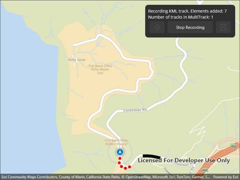
When capturing location data for outdoor activities such as hiking or skiing, it can be useful to record and share your path. This sample demonstrates how you can collect individual KML tracks during a navigation session, then combine and export them as a KML multi-track.
How to use the sample
Tap Start Navigation to begin moving along a simulated trail. Tap Record Track to start recording your current path. Tap Stop Recording to end recording and capture a KML track. Repeat these steps to capture multiple KML tracks in a single session. Tap the Save button to save your recorded tracks as a .kmz file to local storage. Then load the created .kmz file containing your KML multi-track to view all created tracks on the map.
How it works
- Create an
ArcGISMapwith a basemap and aGraphicsOverlayto display the path geometry for your navigation route. - Create a
SimulatedLocationDataSourceto drive theLocationDisplay. - As you receive
Locationupdates, add each point to a list ofKmlTrackElementobjects while recording. - Once recording stops, create a
KmlTrackusing one or moreKmlTrackElementobjects. - Combine one or more
KmlTrackobjects into aKmlMultiTrack. - Save the
KmlMultiTrackinside aKmlDocument, then export the document to a.kmzfile. - Load the saved
.kmzfile into aKmlDatasetand locate theKmlDocumentin the dataset'sRootNodes. From the document'sChildNodesget theKmlPlacemarkand retrieve theKmlMultiTrackgeometry. - Retrieve the geometry of each track in the
KmlMultiTrackby iterating through the list of tracks and obtaining the respectiveKmlTrack.Geometry.
Relevant API
- KmlDataset
- KmlDocument
- KmlMultiTrack
- KmlPlacemark
- KmlTrack
- LocationDisplay
- SimulatedLocationDataSource
Tags
export, geoview-compose, hiking, kml, kmz, multi-track, record, track
Sample Code
// Copyright 2025 Esri.
//
// Licensed under the Apache License, Version 2.0 (the "License"); you may not use this file except in compliance with the License.
// You may obtain a copy of the License at: http://www.apache.org/licenses/LICENSE-2.0
//
// Unless required by applicable law or agreed to in writing, software distributed under the License is distributed on an
// "AS IS" BASIS, WITHOUT WARRANTIES OR CONDITIONS OF ANY KIND, either express or implied. See the License for the specific
// language governing permissions and limitations under the License.
using Esri.ArcGISRuntime.Geometry;
using Esri.ArcGISRuntime.Mapping;
using Esri.ArcGISRuntime.Symbology;
using Esri.ArcGISRuntime.UI;
using Esri.ArcGISRuntime.Location;
using Esri.ArcGISRuntime.Ogc;
using ArcGIS.Samples.Managers;
using Microsoft.Maui.ApplicationModel;
using Map = Esri.ArcGISRuntime.Mapping.Map;
using Location = Esri.ArcGISRuntime.Location.Location;
using System.ComponentModel;
namespace ArcGIS.Samples.CreateKmlMultiTrack
{
[ArcGIS.Samples.Shared.Attributes.Sample(
name: "Create KML multi-track",
category: "Data",
description: "Create, save and preview a KML multi-track, captured from a location data source.",
instructions: "Tap **Start Navigation** to begin moving along a simulated trail. Tap **Record Track** to start recording your current path. Tap **Stop Recording** to end recording and capture a KML track. Repeat these steps to capture multiple KML tracks in a single session. Tap the **Save** button to save your recorded tracks as a `.kmz` file to local storage. Then load the created `.kmz` file containing your KML multi-track to view all created tracks on the map.",
tags: new[] { "export", "geoview-compose", "hiking", "kml", "kmz", "multi-track", "record", "track" })]
[ArcGIS.Samples.Shared.Attributes.OfflineData()]
public partial class CreateKmlMultiTrack
{
// Flag to indicate whether the app is recording a KML track.
private bool _isRecordingTrack = false;
// Lists for storing KML track elements and KML tracks.
private List<KmlTrackElement> _kmlTrackElements = new List<KmlTrackElement>();
private List<KmlTrack> _kmlTracks = new List<KmlTrack>();
// Graphics overlay indexes for the KML track elements and the KML tracks.
private int _elementsIndex = 0;
private int _tracksIndex = 1;
// Symbology to differentiate the KML track elements and the KML tracks.
private SimpleMarkerSymbol _locationSymbol = new SimpleMarkerSymbol(SimpleMarkerSymbolStyle.Circle, System.Drawing.Color.Red, 10);
private SimpleLineSymbol _routeSymbol = new SimpleLineSymbol(SimpleLineSymbolStyle.Solid, System.Drawing.Color.Black, 10);
// Route geometry for the simulation.
private Polyline _routeGeometry;
// File path for the .kmz file.
private string _filePath;
// Dictionary to store the KML tracks and their names.
private Dictionary<string, Geometry> _tracksDictionary = new Dictionary<string, Geometry>();
public CreateKmlMultiTrack()
{
InitializeComponent();
Initialize();
}
private void Initialize()
{
// Create a map with a street basemap style.
MyMapView.Map = new Map(BasemapStyle.ArcGISStreets);
// Get the hiking path geometry.
_routeGeometry = Geometry.FromJson(COASTAL_TRAIL_JSON) as Polyline;
// Set the map's initial viewpoint.
MyMapView.SetViewpoint(new Viewpoint(_routeGeometry, 25));
MyMapView.PropertyChanged += MyMapView_PropertyChanged;
// Add graphics overlays for the KML track elements and the KML tracks.
MyMapView.GraphicsOverlays.Add(new GraphicsOverlay());
MyMapView.GraphicsOverlays.Add(new GraphicsOverlay());
// Define the save file path.
_filePath = Path.Combine(DataManager.GetDataFolder(), "SampleData", "CreateKmlMultiTrack", "HikingTracks", "HikingTracks.kmz");
}
/// <summary>
/// // The map view's location display is initially null, so check for a location display property change before enabling it, configuring the simulated data source, and subscribing to location changes.
/// </summary>
private void MyMapView_PropertyChanged(object sender, PropertyChangedEventArgs e)
{
if (e.PropertyName == nameof(LocationDisplay))
{
// Create a simulated location data source from json data with simulation parameters to set a consistent velocity.
var simulatedLocationDataSource = new SimulatedLocationDataSource();
simulatedLocationDataSource.SetLocationsWithPolyline(
_routeGeometry,
new SimulationParameters(DateTimeOffset.Now, 25, 0, 0));
// Set the simulated location data source as the location data source for this app.
MyMapView.LocationDisplay.DataSource = simulatedLocationDataSource;
// Enable the recenter button when autopan mode isn't navigation.
MyMapView.LocationDisplay.AutoPanModeChanged += (s, e) =>
{
RecenterButton.IsEnabled = MyMapView.LocationDisplay.AutoPanMode != LocationDisplayAutoPanMode.Navigation;
};
StartNavigation();
// Unsubscribe now that the location display has been initialized.
MyMapView.PropertyChanged -= MyMapView_PropertyChanged;
}
}
#region KML track recording state
/// <summary>
/// Toggles the recording state and updates the UI accordingly. A KML track is created from the recorded elements when recording is stopped.
/// </summary>
private void RecordTrackButton_Clicked(object sender, EventArgs e)
{
// Toggle the recording state.
_isRecordingTrack = !_isRecordingTrack;
// Update the UI based on the recording state.
if (!_isRecordingTrack)
{
RecordTrackButton.Text = "Start Recording";
ElementsCountLabel.Text = "Clicked record to capture KML track elements.";
SaveButton.IsEnabled = true;
DisplayKmlTrack();
}
else
{
RecordTrackButton.Text = "Stop Recording";
ElementsCountLabel.Text = "Recording KML track. Elements added: 0";
SaveButton.IsEnabled = false;
ElementsCountLabel.IsVisible = true;
RecordTrackButton.IsEnabled = false;
}
}
/// <summary>
/// Creates a KML track and displays it on the map.
/// </summary>
private void DisplayKmlTrack()
{
// Remove the red location markers from the map.
MyMapView.GraphicsOverlays[_elementsIndex].Graphics.Clear();
// Create a new KML track from the recorded elements.
var kmlTrack = new KmlTrack(_kmlTrackElements, KmlAltitudeMode.RelativeToGround);
_kmlTracks.Add(kmlTrack);
// Set the KML geometry to use the same projection as the map.
var multipoint = kmlTrack.Geometry as Multipoint;
// Add the KML track as a graphic to the map.
var graphic = new Graphic(new Polyline(multipoint.Points), _routeSymbol);
MyMapView.GraphicsOverlays[_tracksIndex].Graphics.Add(graphic);
// Clear the list of track elements.
_kmlTrackElements.Clear();
// Increment the track count in the UI.
TracksCountLabel.Text = $"Number of tracks in MultiTrack: {_kmlTracks.Count}";
}
/// <summary>
/// When recording is enabled, add the given location to the list
/// of KML track elements and display the graphic on the map.
/// </summary>
private void LocationDisplay_LocationChanged(object sender, Location e)
{
if (_isRecordingTrack)
{
// Ensure the code runs on the UI thread.
MainThread.BeginInvokeOnMainThread(() =>
{
// Add a new element to the KMl track.
_kmlTrackElements.Add(new KmlTrackElement(DateTime.Now, e.Position));
// Add a graphic at the location's position.
MyMapView.GraphicsOverlays[_elementsIndex].Graphics.Add(new Graphic(e.Position, _locationSymbol));
ElementsCountLabel.Text = $"Recording KML track. Elements added: {_kmlTrackElements.Count}";
// KML tracks require at least two elements to be valid, so recording can only be stopped when this requirement is met.
if (_kmlTrackElements.Count >= 2)
{
RecordTrackButton.IsEnabled = true;
}
});
}
}
/// <summary>
/// Recenters the map view on the simulated location. This is helpful after panning away from the location.
/// </summary>
private void RecenterButton_Clicked(object sender, EventArgs e)
{
MyMapView.LocationDisplay.AutoPanMode = LocationDisplayAutoPanMode.Navigation;
}
#endregion KML track recording state
#region KML track viewing state
/// <summary>
/// Saves the KML muli-track to a file, loads it back and displays it on the map. Transitions the UI to the KML track viewing state.
/// </summary>
private async void SaveButton_Clicked(object sender, EventArgs e)
{
ToggleUIVisibility();
await ExportKlmMultiTrack();
_kmlTracks.Clear();
StopNavigation();
await LoadLocalKmlFile();
}
/// <summary>
/// Exports the KML multi-track to a .kmz file.
/// </summary>
private async Task ExportKlmMultiTrack()
{
// Create a default KML document which will export file to device.
var kmlDocument = new KmlDocument();
// Create a KML multi track using the current list of tracks.
var multiTrack = new KmlMultiTrack(_kmlTracks);
// Add the multi track as a placemark KML node to the KML document.
kmlDocument.ChildNodes.Add(new KmlPlacemark(multiTrack));
// Delete the file if it already exists.
if (File.Exists(_filePath))
{
File.Delete(_filePath);
}
// Save the KML document to the file path.
await kmlDocument.SaveAsAsync(_filePath);
}
/// <summary>
/// Loads a local KML file and displays the KML tracks on the map. Adds the KML tracks to the combo box for selection.
/// </summary>
private async Task LoadLocalKmlFile()
{
// Create a KML dataset using the local file path.
var kmlDataset = new KmlDataset(new Uri(_filePath));
// Load the KML dataset.
await kmlDataset.LoadAsync();
// Get the document's node which contains the placemark.
var kmlDocument = kmlDataset.RootNodes.OfType<KmlDocument>().FirstOrDefault();
var kmlPlacemark = kmlDocument.ChildNodes.OfType<KmlPlacemark>().FirstOrDefault();
// Get the multi-track geometry from the placemark.
var kmlMultiTrack = kmlPlacemark.KmlGeometry as KmlMultiTrack;
// Obtain all the KML tracks from the multi-track.
var trackGeometries = kmlMultiTrack.Tracks.Select(track => track.Geometry);
// Calculate the union of all the KML tracks.
var allTracksGeometry = GeometryEngine.Union(trackGeometries);
// Clear track graphics from the previous UI state.
MyMapView.GraphicsOverlays[_tracksIndex].Graphics.Clear();
// Project the KML tracks to the map's spatial reference and add them as graphics to the map.
// Populate a dictionary with the track names as keys and the track geometries as values.
_tracksDictionary.Add("Show all KLM tracks", allTracksGeometry);
for (int i = 0; i < kmlMultiTrack.Tracks.Count; i++)
{
var trackGeometry = kmlMultiTrack.Tracks[i].Geometry as Multipoint;
MyMapView.GraphicsOverlays[_tracksIndex].Graphics.Add(new Graphic(new Polyline(trackGeometry.Points), _routeSymbol));
_tracksDictionary.Add($"Track {i + 1}", trackGeometry);
}
// Set the combo box's item source to the dictionary.
TracksPicker.ItemsSource = _tracksDictionary.Keys.ToList();
// Set the viewpoint to the union geometry by invoking the selection changed event.
TracksPicker.SelectedIndex = 0;
}
/// <summary>
/// Zooms to the selected KML track.
/// </summary>
private void TracksPicker_SelectionChanged(object sender, EventArgs e)
{
if (TracksPicker.ItemsSource != null)
{
// TODO: implement tracks picker item lookup.
Geometry selectedGeometry = _tracksDictionary[TracksPicker.SelectedItem.ToString()];
// Set the viewpoint to the selected geometry.
MyMapView.SetViewpointGeometryAsync(selectedGeometry, 25);
}
}
#endregion KML track viewing state
#region Start and stop navigation
/// <summary>
/// Configures and starts the location display for navigation.
/// </summary>
private void StartNavigation()
{
// Start the location data source.
MyMapView.LocationDisplay.DataSource.StartAsync();
// Set the location display to auto pan mode.
MyMapView.LocationDisplay.AutoPanMode = LocationDisplayAutoPanMode.Navigation;
// Listen for changes in location.
MyMapView.LocationDisplay.LocationChanged += LocationDisplay_LocationChanged;
// Enable the location display.
MyMapView.LocationDisplay.IsEnabled = true;
}
/// <summary>
/// Turns off the location display and stops listening for location changes.
/// </summary>
private void StopNavigation()
{
MyMapView.LocationDisplay.IsEnabled = false;
MyMapView.LocationDisplay.LocationChanged -= LocationDisplay_LocationChanged;
MyMapView.LocationDisplay.DataSource.StopAsync();
MyMapView.LocationDisplay.AutoPanMode = LocationDisplayAutoPanMode.Off;
}
#endregion Start and stop navigation
#region Change UI state
/// <summary>
/// Resets the state for KML track recording.
/// </summary>
private void ResetButton_Clicked(object sender, EventArgs e)
{
ToggleUIVisibility();
StartNavigation();
TracksCountLabel.Text = "Number of tracks in MultiTrack: 0";
SaveButton.IsEnabled = false;
TracksPicker.ItemsSource = null;
_tracksDictionary.Clear();
MyMapView.GraphicsOverlays[_tracksIndex].Graphics.Clear();
}
/// <summary>
/// Toggles the visibility of the recording and viewing UIs.
/// </summary>
private void ToggleUIVisibility()
{
RecordingUI.IsVisible = !RecordingUI.IsVisible;
ViewingUI.IsVisible = !ViewingUI.IsVisible;
}
#endregion Change UI state
#region Data
private const string COASTAL_TRAIL_JSON =
"""
{ "paths" : [ [ [ -122.4835314726743, 37.83211865911945 ], [ -122.48368189197535, 37.83187118241683 ], [ -122.48380566095689, 37.83165751914316 ], [ -122.48388894197024, 37.83145169600181 ], [ -122.48397936099687, 37.83118043717595 ], [ -122.48400315647044, 37.83104956678124 ], [ -122.48402338114072, 37.830918696154455 ], [ -122.48402814041512, 37.830775928900714 ], [ -122.48402725647286, 37.83065575512642 ], [ -122.4840254014518, 37.8306072300538 ], [ -122.48401768492351, 37.83055928604177 ], [ -122.48400422097404, 37.830512629058774 ], [ -122.48398520902936, 37.8304679452088 ], [ -122.48396092666893, 37.83042589221653 ], [ -122.48393173142219, 37.83038708736564 ], [ -122.48389805358218, 37.83035210182205 ], [ -122.48386038812063, 37.830321452119506 ], [ -122.4837611170952, 37.83025151926742 ], [ -122.48375681057175, 37.830247746053175 ], [ -122.48366652719073, 37.83019051634461 ], [ -122.48350989334455, 37.83007565307785 ], [ -122.48338378245505, 37.82997452594437 ], [ -122.48337304219753, 37.82996166234225 ], [ -122.48334246534189, 37.82993380302198 ], [ -122.48331659206505, 37.82990152834285 ], [ -122.48330212200248, 37.829883812313646 ], [ -122.48328996510173, 37.82986443529098 ], [ -122.48327420775335, 37.82983760474022 ], [ -122.4832628090307, 37.82980865270958 ], [ -122.48325604381832, 37.82977828304244 ], [ -122.48325465951446, 37.829736521980415 ], [ -122.48325940890734, 37.82969500922772 ], [ -122.48327019228401, 37.829654640912736 ], [ -122.48328677518418, 37.82961628833229 ], [ -122.48330880007832, 37.829580780923116 ], [ -122.48333579085934, 37.82954888426596 ], [ -122.48336716541894, 37.82952128802347 ], [ -122.4833988256428, 37.82949318304136 ], [ -122.48343379705682, 37.82946932029889 ], [ -122.4834715110274, 37.82945008578193 ], [ -122.4835113611917, 37.82943579026623 ], [ -122.48355047743246, 37.82942204817761 ], [ -122.48359096270566, 37.82941311099388 ], [ -122.48363223041152, 37.82940911210755 ], [ -122.4836736777804, 37.829410106152956 ], [ -122.48383061435887, 37.8294303950351 ], [ -122.48388774451598, 37.82944460824695 ], [ -122.48394601373688, 37.82945299696391 ], [ -122.48400483272674, 37.82945547462583 ], [ -122.48433804301844, 37.82945355606976 ], [ -122.4847002015202, 37.82946846815932 ], [ -122.48476089259908, 37.82947500572284 ], [ -122.48482190527488, 37.82947691789268 ], [ -122.48488387645307, 37.82947778706078 ], [ -122.48494567066315, 37.82947301692427 ], [ -122.48500677406878, 37.82946264792504 ], [ -122.48504444851348, 37.82945476510069 ], [ -122.48508119410018, 37.829443311944246 ], [ -122.48511667575728, 37.829428394173405 ], [ -122.48516495211896, 37.82940757456553 ], [ -122.48521008617378, 37.829380612586306 ], [ -122.48525130267564, 37.82934797296873 ], [ -122.48535147291467, 37.829272927762155 ], [ -122.48573645311619, 37.82892955211324 ], [ -122.48591674050213, 37.828760237428405 ], [ -122.48595566360507, 37.82873302900504 ], [ -122.48598939803894, 37.828721079063996 ], [ -122.48602446467437, 37.82871392059287 ], [ -122.48606018438501, 37.82871169053279 ], [ -122.48609110799036, 37.82871612794789 ], [ -122.48612131833336, 37.82872408393298 ], [ -122.48615041656204, 37.82873545347624 ], [ -122.48626991585101, 37.82881679064391 ], [ -122.48686379927189, 37.82921515592806 ], [ -122.48689678540913, 37.82924047754071 ], [ -122.48692585219676, 37.82927021665974 ], [ -122.48695041303496, 37.829303773729634 ], [ -122.48696997295194, 37.82934047185724 ], [ -122.48698413579072, 37.82937956958323 ], [ -122.48699261768361, 37.82942028074957 ], [ -122.48699524795076, 37.8294617815949 ], [ -122.48699197179495, 37.82950323771682 ], [ -122.48698398038215, 37.82993403361622 ], [ -122.48700845677871, 37.830648260533444 ], [ -122.48700761056573, 37.83067257982134 ], [ -122.48700868764573, 37.83069688916802 ], [ -122.48701571875947, 37.83075467119421 ], [ -122.48702933272759, 37.830811264742294 ], [ -122.48704934898875, 37.83086592269937 ], [ -122.48707550253995, 37.83091792491589 ], [ -122.48710744842808, 37.83096658317209 ], [ -122.48714476713994, 37.83101125465843 ], [ -122.487323504932, 37.83124731116835 ], [ -122.48741675724503, 37.83139446297001 ], [ -122.48744101984254, 37.831443582800446 ], [ -122.4875141148589, 37.831616409760244 ], [ -122.48754615776508, 37.83168849608147 ], [ -122.48758326177958, 37.83175811184267 ], [ -122.48762523915447, 37.83182490300923 ], [ -122.48767187429414, 37.831888529737434 ], [ -122.4877229300433, 37.83194866566494 ], [ -122.48777814589057, 37.83200500713399 ], [ -122.48783724066321, 37.832057264677225 ], [ -122.48786344182511, 37.83207726690301 ], [ -122.48786530403268, 37.83207815590645 ], [ -122.48807228126402, 37.832205450731635 ], [ -122.4881376372942, 37.83225954857125 ], [ -122.48819890958313, 37.83231823185467 ], [ -122.48825577473723, 37.83238119406823 ], [ -122.4882838668528, 37.83243614956031 ], [ -122.48831646581614, 37.83248855792079 ], [ -122.48835334255688, 37.8325380487985 ], [ -122.48839423836019, 37.83258427454664 ], [ -122.48843886396857, 37.83262691093234 ], [ -122.48848690586995, 37.832665657136175 ], [ -122.48865428895684, 37.8327738428775 ], [ -122.48875650735471, 37.83282875408856 ], [ -122.48884649069839, 37.83286507585097 ], [ -122.48889117020568, 37.83287425171545 ], [ -122.48893661867086, 37.83287811702946 ], [ -122.4889822063749, 37.832876618581736 ], [ -122.48902730359879, 37.832869777656875 ], [ -122.48907128421679, 37.83285768790635 ], [ -122.48911354096774, 37.83284051818675 ], [ -122.4891724542807, 37.83282177764611 ], [ -122.48954335069523, 37.832650632883166 ], [ -122.48959461575184, 37.83262831147479 ], [ -122.48964780230489, 37.83261106152894 ], [ -122.48970240909438, 37.8325990441045 ], [ -122.48975792408062, 37.83259237201367 ], [ -122.48981382354579, 37.83259110769355 ], [ -122.48986958377212, 37.83259526462479 ], [ -122.48992467744847, 37.83260480307474 ], [ -122.48997621110139, 37.832614560047894 ], [ -122.49002627960206, 37.8326301859597 ], [ -122.49007421460394, 37.832651473634094 ], [ -122.49011937920147, 37.832678140687506 ], [ -122.49016117242178, 37.832709830948126 ], [ -122.49023068226181, 37.83275956574309 ], [ -122.49026306922278, 37.832780573839855 ], [ -122.49030543556819, 37.832804600113775 ], [ -122.49035076635404, 37.83282241193269 ], [ -122.49039815518022, 37.83283365384526 ], [ -122.49044665612074, 37.832838101654836 ], [ -122.49049530079171, 37.832835668094994 ], [ -122.490543114521, 37.832826398572614 ], [ -122.49058914419615, 37.8328104811008 ], [ -122.49063246994231, 37.832788230690106 ], [ -122.49067222578353, 37.8327600950252 ], [ -122.49070761671078, 37.832726634599354 ], [ -122.49073793664826, 37.832688518458234 ], [ -122.49082473456593, 37.83257808774918 ], [ -122.49086935029284, 37.83252239945379 ], [ -122.49089077062078, 37.83249764301668 ], [ -122.49091592883865, 37.83247669443703 ], [ -122.49094415659981, 37.83246011351073 ], [ -122.49098463019493, 37.83244232147022 ], [ -122.49099373372202, 37.83243859590428 ], [ -122.4910023314976, 37.83243381744524 ], [ -122.49101030224914, 37.83242805491412 ], [ -122.491018105914, 37.832420952852864 ], [ -122.49102474266732, 37.832412749652015 ], [ -122.49103005889717, 37.832403635456345 ], [ -122.49103393063605, 37.83239382098607 ], [ -122.49103627074737, 37.832383531860984 ], [ -122.49103702353558, 37.832373007890915 ], [ -122.49103937263004, 37.832361138003094 ], [ -122.49104356327085, 37.83234978675593 ], [ -122.49104948945677, 37.83233923794863 ], [ -122.49105700476245, 37.8323297548051 ], [ -122.49106591964332, 37.83232157358853 ], [ -122.49107601221553, 37.832314899344134 ], [ -122.49108703095081, 37.83230989951385 ], [ -122.49109869916803, 37.83230669755051 ], [ -122.49114375147617, 37.83229005485964 ], [ -122.49119043153159, 37.83227875894242 ], [ -122.49123810781863, 37.832272960924264 ], [ -122.4912861344487, 37.83227273956087 ], [ -122.49133386283806, 37.83227809981875 ], [ -122.4913806444031, 37.83228896648985 ], [ -122.4914497032889, 37.832311761945334 ], [ -122.49146307830515, 37.83231896973225 ], [ -122.49147522262948, 37.832328100966336 ], [ -122.49148585958076, 37.83233894989266 ], [ -122.49149475020712, 37.83235127031487 ], [ -122.49150169418427, 37.832364784818786 ], [ -122.4915065334087, 37.83237918761059 ], [ -122.49150915828595, 37.83239415232114 ], [ -122.49151461734795, 37.832407376633014 ], [ -122.49152190987142, 37.83241968569183 ], [ -122.49153088583776, 37.83243082691724 ], [ -122.49154136109226, 37.83244057185197 ], [ -122.49155312093764, 37.83244871970903 ], [ -122.49165264708462, 37.83251124050483 ], [ -122.49170158370804, 37.83254221992262 ], [ -122.4917477903513, 37.83257714057318 ], [ -122.49179095080746, 37.832615762641574 ], [ -122.49183076953072, 37.83265782289962 ], [ -122.49186697253498, 37.832703031867915 ], [ -122.49202598601836, 37.83298442443593 ], [ -122.49210611574172, 37.833117423416 ], [ -122.4921433778597, 37.833163624678505 ], [ -122.49218487014437, 37.83320606845782 ], [ -122.49223021440496, 37.83324436879858 ], [ -122.49227900100973, 37.833278177348404 ], [ -122.49233078259763, 37.83330718761463 ], [ -122.49238509294308, 37.83333113567338 ], [ -122.49283970066398, 37.833413136821356 ], [ -122.49312652105611, 37.833456201967486 ], [ -122.49324314304124, 37.833477260948875 ], [ -122.49335882538858, 37.83350298834403 ], [ -122.49346332011737, 37.83352714847554 ], [ -122.49356913536963, 37.83354464156086 ], [ -122.49361827052074, 37.83355233593457 ], [ -122.49366794825427, 37.833554671561714 ], [ -122.49371758825855, 37.8335516214824 ], [ -122.49379700112628, 37.83354132258596 ], [ -122.49387536745672, 37.83352485257872 ], [ -122.4939522075495, 37.83350231291309 ], [ -122.49402705248401, 37.8334738398049 ], [ -122.49409944501782, 37.83343960849056 ], [ -122.49416925579352, 37.83339903363501 ], [ -122.49423571225992, 37.83335316881714 ], [ -122.49429841197178, 37.83330228930838 ], [ -122.49453762434882, 37.83312377476988 ], [ -122.49458938886875, 37.83308543179706 ], [ -122.49463757809386, 37.83304268215786 ], [ -122.49468181832493, 37.83299585717693 ], [ -122.49472176550732, 37.83294532010619 ], [ -122.49475710882386, 37.83289146470621 ], [ -122.49478757608503, 37.83283470531341 ], [ -122.4948129292373, 37.83277548677341 ], [ -122.49483297244791, 37.832714265284764 ], [ -122.49498619000107, 37.83220090142562 ], [ -122.49499765340244, 37.83214462608956 ], [ -122.49501311430679, 37.83208931633994 ], [ -122.4950265324422, 37.83204720609278 ], [ -122.49504488143018, 37.832006999411824 ], [ -122.49506789806439, 37.83196926957701 ], [ -122.49509525445976, 37.83193455723217 ], [ -122.49513805738638, 37.831887085191816 ], [ -122.49518490452846, 37.83184359839491 ], [ -122.4952354239834, 37.83180443953837 ], [ -122.49528811107314, 37.83176867421362 ], [ -122.49534435369475, 37.83173881122903 ], [ -122.4954034942815, 37.83171519895808 ], [ -122.49546483933392, 37.83169811553204 ], [ -122.49552767019985, 37.831687758197596 ], [ -122.49559125295568, 37.83168425041114 ], [ -122.4961075955978, 37.8317212872069 ], [ -122.49613495289148, 37.8317209069131 ], [ -122.49623972789465, 37.831720735213274 ], [ -122.49634437623536, 37.83171555512881 ], [ -122.49644865626678, 37.831705381558166 ], [ -122.49655233173205, 37.8316902343655 ], [ -122.49665516457756, 37.83167015115136 ], [ -122.49675691944475, 37.831645175901 ], [ -122.4967770479953, 37.831640510911264 ], [ -122.49697923361293, 37.831584102470416 ], [ -122.49705029394518, 37.831565446041715 ], [ -122.4971199556005, 37.83154209694165 ], [ -122.49718790506692, 37.831514159463005 ], [ -122.4972538423071, 37.831481754926116 ], [ -122.49726954395994, 37.8314719644564 ], [ -122.49730905635771, 37.83144600931114 ], [ -122.49734523959904, 37.831415584976455 ], [ -122.49737759152569, 37.83138111431287 ], [ -122.49740566118335, 37.83134307623196 ], [ -122.4974290604999, 37.831301999311215 ], [ -122.4974474624885, 37.83125845328032 ], [ -122.49746061202762, 37.83121304476455 ], [ -122.49750996457102, 37.83101837743121 ], [ -122.49752449122748, 37.83096557992402 ], [ -122.49754512013965, 37.83091485415169 ], [ -122.49757156474499, 37.83086690395394 ], [ -122.49760345853082, 37.830822391310846 ], [ -122.4976403604244, 37.830781932795055 ], [ -122.49767692275478, 37.830737544975015 ], [ -122.49771008047021, 37.830705203953194 ], [ -122.49774190149253, 37.83067164397307 ], [ -122.49777243343242, 37.83063874169697 ], [ -122.49780693053596, 37.830610026248856 ], [ -122.4978448250679, 37.83058597017017 ], [ -122.49788549180082, 37.83056697008407 ], [ -122.49808111881853, 37.83047276281848 ], [ -122.49814084331021, 37.83044946232918 ], [ -122.49818555605516, 37.83043219484554 ], [ -122.4982277580089, 37.830409473308514 ], [ -122.49826678801135, 37.830381650342645 ], [ -122.49830203161491, 37.83034916513296 ], [ -122.49833293545731, 37.8303125271065 ], [ -122.4983590144483, 37.83027231167552 ], [ -122.49837986075279, 37.8302291510146 ], [ -122.49839514468903, 37.83018372199883 ], [ -122.49840462640687, 37.83013673910934 ], [ -122.49840815858256, 37.830088938114436 ], [ -122.49840568462227, 37.83004107110319 ], [ -122.49823317035847, 37.829449845962415 ], [ -122.49822651204559, 37.82942865385972 ], [ -122.4982172620931, 37.829391938747385 ], [ -122.49819795999261, 37.82932136218335 ], [ -122.49817403516164, 37.82925221595857 ], [ -122.4981455918048, 37.82918480162631 ], [ -122.49811275568624, 37.82911941506465 ], [ -122.4980756678414, 37.82905634221925 ], [ -122.49802898778596, 37.82899575693072 ], [ -122.49797913488098, 37.82893775357273 ], [ -122.4979262519585, 37.82888249960063 ], [ -122.49789337182249, 37.8288388669981 ], [ -122.4978645260204, 37.8287924679063 ], [ -122.49783994452095, 37.828743674824274 ], [ -122.49781982405521, 37.828692880118815 ], [ -122.49780400292644, 37.82863373701263 ], [ -122.49778639415025, 37.82857510188516 ], [ -122.49776761846248, 37.82851554218796 ], [ -122.49775808104911, 37.8284864001929 ], [ -122.49775257527475, 37.82845623503713 ], [ -122.49775120175067, 37.828425602994976 ], [ -122.49775398742636, 37.82839506672737 ], [ -122.4977558891598, 37.82837721907239 ], [ -122.49775589005814, 37.82835926853041 ], [ -122.49775315738304, 37.828339510796106 ], [ -122.49775289238003, 37.82831956715807 ], [ -122.49775509864237, 37.828299742716744 ], [ -122.49775504025189, 37.82829435307889 ], [ -122.49775412307199, 37.828289042199195 ], [ -122.49775237225548, 37.828283944179994 ], [ -122.49774983181987, 37.828279189576165 ], [ -122.49774656824043, 37.828274899718394 ], [ -122.4977426623656, 37.828271186004095 ], [ -122.49773821480662, 37.82826813996359 ], [ -122.49772966823501, 37.828263032009424 ], [ -122.49772202986013, 37.828256644760316 ], [ -122.49771549102317, 37.828249135732946 ], [ -122.49771298292691, 37.82824308693168 ], [ -122.49771131385711, 37.828236755734196 ], [ -122.49771051615315, 37.828230255666426 ], [ -122.4977106023914, 37.82822370876859 ], [ -122.49771194088117, 37.82820150380411 ], [ -122.49771620248889, 37.82817967063058 ], [ -122.4977233090611, 37.828158591689146 ], [ -122.49773313932525, 37.828138636649626 ], [ -122.4977483127687, 37.82811292015561 ], [ -122.49776756636018, 37.82809009502134 ], [ -122.49779035841559, 37.828070802672265 ], [ -122.4978160493344, 37.828055583779545 ], [ -122.49783288016957, 37.828045169880234 ], [ -122.49786895291813, 37.82803058105274 ], [ -122.4978894884055, 37.828020969638466 ], [ -122.49791097970038, 37.82801374653139 ], [ -122.49791707926114, 37.828012578630116 ], [ -122.49793710720041, 37.82800721380515 ], [ -122.49795773431596, 37.828005095121334 ], [ -122.49797843509337, 37.82800627579443 ], [ -122.49799868581479, 37.82801072673316 ], [ -122.49801515103566, 37.82801536215173 ], [ -122.49803215704229, 37.828017199148256 ], [ -122.49804923311754, 37.82801618805518 ], [ -122.49806590315424, 37.82801235583484 ], [ -122.49833957490557, 37.827932762538865 ], [ -122.49834853021062, 37.82793002158651 ], [ -122.49835701030693, 37.82792604603464 ], [ -122.49836484271789, 37.82792091393246 ], [ -122.49837187472993, 37.82791472887262 ], [ -122.49837796530757, 37.8279076136052 ], [ -122.49839488058437, 37.827888585866916 ], [ -122.49841417100677, 37.82787197198021 ], [ -122.4984354961133, 37.82785806498696 ], [ -122.49845847950984, 37.82784711180884 ], [ -122.4984945594449, 37.82783261305393 ], [ -122.4985323084498, 37.82781874507803 ], [ -122.49856835155393, 37.827800905798135 ], [ -122.49860227104074, 37.827779301687926 ], [ -122.49862292330913, 37.82776567139835 ], [ -122.49864314258954, 37.82775238594348 ] ] ], "spatialReference" : { "wkid" : 4326 } }
""";
#endregion Data
}
}