Display and configure electronic navigational charts per ENC specification.
Use case
The S-52 standard defines how Electronic Navigational Chart (ENC) content should be displayed to ensure that data is presented consistently across every charting system. S-52 defines several display options, including variations on symbology to ensure that charts are readable both at night and in direct sunlight.
How to use the sample
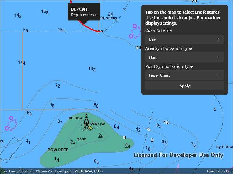
When opened, the sample displays an electronic navigational chart. Tap on the map to select Enc features and view the feature's acronyms and descriptions shown in a callout. Tap "Display Settings" and use the options to adjust some of the Enc mariner display settings, such as the colors and symbology.
How it works
- To display Enc content:
- Create an
EncExchangeSetusing a path to the local Enc exchange set files and load it. - Make an
EncCellfor each of theEncExchangeSet.Datasetsand then make anEncLayerfrom each cell. - Add the layers to the map using
Map.OperationalLayers.Add()and create aMapViewto display the map.
- Create an
- To select Enc features:
- Use
GeoViewTapped()on the map view to get the screen point from the tapped location. - Identify nearby features to the tapped location with
IdentifyLayersAsync(). - From the resulting
IdentifyLayerResult, get theEncLayerfromLayerContentand theEncFeature(s) fromGeoElements. - Use
EncLayer.SelectFeature()to select the Enc feature(s).
- Use
- To set Enc display settings:
- Get the
EncDisplaySettingsinstance fromEncEnvironmentSettings.Default.DisplaySettings. - Use
MarinerSettings,TextGroupVisibilitySettings, andViewingGroupSettingsto access the settings instances and set their properties. - Reset the display settings using
ResetToDefaults()on the settings instances.
- Get the
Relevant API
- EncCell
- EncDataset
- EncDisplaySettings
- EncEnvironmentSettings
- EncExchangeSet
- EncLayer
- EncMarinerSettings
- EncTextGroupVisibilitySettings
- EncViewingGroupSettings
- IdentifyLayerResult
Offline data
This sample downloads the ENC Exchange Set without updates item from ArcGIS Online automatically.
The latest Hydrography Data can be downloaded from the Esri Developer downloads. The S57DataDictionary.xml file is contained there.
Additional information
Read more about displaying and deploying electronic navigational charts on Esri Developer.
Tags
ENC, hydrography, identify, IHO, layers, maritime, nautical chart, S-52, S-57, select, settings, symbology
Sample Code
// Copyright 2022 Esri.
//
// Licensed under the Apache License, Version 2.0 (the "License"); you may not use this file except in compliance with the License.
// You may obtain a copy of the License at: http://www.apache.org/licenses/LICENSE-2.0
//
// Unless required by applicable law or agreed to in writing, software distributed under the License is distributed on an
// "AS IS" BASIS, WITHOUT WARRANTIES OR CONDITIONS OF ANY KIND, either express or implied. See the License for the specific
// language governing permissions and limitations under the License.
using ArcGIS.Samples.Managers;
using Esri.ArcGISRuntime.Data;
using Esri.ArcGISRuntime.Geometry;
using Esri.ArcGISRuntime.Hydrography;
using Esri.ArcGISRuntime.Mapping;
using Esri.ArcGISRuntime.UI;
namespace ArcGIS.Samples.ConfigureElectronicNavigationalCharts
{
[ArcGIS.Samples.Shared.Attributes.Sample(
name: "Configure electronic navigational charts",
category: "Layers",
description: "Display and configure electronic navigational charts per ENC specification.",
instructions: "When opened, the sample displays an electronic navigational chart. Tap on the map to select Enc features and view the feature's acronyms and descriptions shown in a callout. Tap \"Display Settings\" and use the options to adjust some of the Enc mariner display settings, such as the colors and symbology.",
tags: new[] { "ENC", "IHO", "S-52", "S-57", "hydrography", "identify", "layers", "maritime", "nautical chart", "select", "settings", "symbology" })]
[ArcGIS.Samples.Shared.Attributes.OfflineData("9d2987a825c646468b3ce7512fb76e2d")]
public partial class ConfigureElectronicNavigationalCharts : ContentPage, IDisposable
{
public ConfigureElectronicNavigationalCharts()
{
InitializeComponent();
// Create the UI, setup the control references and execute initialization.
_ = Initialize();
}
private async Task Initialize()
{
// Add display options to UI.
ColorSchemePicker.ItemsSource = new List<String>() { "Day", "Dusk", "Night" };
AreaPicker.ItemsSource = new List<String>() { "Plain", "Symbolized" };
PointPicker.ItemsSource = new List<String>() { "Paper Chart", "Simplified" };
// Provide initial selection.
ColorSchemePicker.SelectedIndex = 0; AreaPicker.SelectedIndex = 0; PointPicker.SelectedIndex = 0;
// Apply initial display settings.
UpdateDisplaySettings();
// Initialize the map with an oceans basemap.
MyMapView.Map = new Map(BasemapStyle.ArcGISOceans);
// Get the path to the ENC Exchange Set.
string encPath = DataManager.GetDataFolder("9d2987a825c646468b3ce7512fb76e2d", "ExchangeSetwithoutUpdates", "ENC_ROOT",
"CATALOG.031");
// Create the Exchange Set.
// Note: this constructor takes an array of paths because so that update sets can be loaded alongside base data.
EncExchangeSet myEncExchangeSet = new EncExchangeSet(new string[] { encPath });
try
{
// Wait for the exchange set to load.
await myEncExchangeSet.LoadAsync();
// Store a list of data set extent's - will be used to zoom the mapview to the full extent of the Exchange Set.
List<Envelope> dataSetExtents = new List<Envelope>();
// Add each data set as a layer.
foreach (EncDataset myEncDataSet in myEncExchangeSet.Datasets)
{
EncLayer myEncLayer = new EncLayer(new EncCell(myEncDataSet));
// Add the layer to the map.
MyMapView.Map.OperationalLayers.Add(myEncLayer);
// Wait for the layer to load.
await myEncLayer.LoadAsync();
// Add the extent to the list of extents.
dataSetExtents.Add(myEncLayer.FullExtent);
}
// Use the geometry engine to compute the full extent of the ENC Exchange Set.
Envelope fullExtent = dataSetExtents.CombineExtents();
// Set the viewpoint.
await MyMapView.SetViewpointAsync(new Viewpoint(fullExtent));
}
catch (Exception e)
{
await Application.Current.Windows[0].Page.DisplayAlert("Error", e.ToString(), "OK");
}
}
private void UpdateDisplaySettings()
{
// Hold a reference to the application-wide ENC Display Settings.
EncDisplaySettings globalDisplaySettings = EncEnvironmentSettings.Default.DisplaySettings;
// Hold a reference to the application-wide ENC Mariner Settings (part of display settings).
EncMarinerSettings globalMarinerSettings = globalDisplaySettings.MarinerSettings;
// Apply color scheme.
string selectedTheme = ColorSchemePicker.SelectedItem.ToString();
switch (selectedTheme)
{
case "Day":
globalMarinerSettings.ColorScheme = EncColorScheme.Day;
break;
case "Dusk":
globalMarinerSettings.ColorScheme = EncColorScheme.Dusk;
break;
case "Night":
globalMarinerSettings.ColorScheme = EncColorScheme.Night;
break;
}
// Apply area symbolization.
string selectedAreaType = AreaPicker.SelectedItem.ToString();
globalMarinerSettings.AreaSymbolizationType = selectedAreaType == "Plain" ? EncAreaSymbolizationType.Plain : EncAreaSymbolizationType.Symbolized;
// Apply point symbolization.
string selectedPointType = PointPicker.SelectedItem.ToString();
globalMarinerSettings.PointSymbolizationType = selectedPointType == "Paper Chart" ? EncPointSymbolizationType.PaperChart : EncPointSymbolizationType.Simplified;
}
private void Button_Clicked(object sender, EventArgs e)
{
UpdateDisplaySettings();
}
private void ClearAllSelections()
{
// For each layer in the operational layers that is an ENC layer
foreach (EncLayer layer in MyMapView.Map.OperationalLayers.OfType<EncLayer>())
{
// Clear the layer's selection
layer.ClearSelection();
}
// Clear the callout
MyMapView.DismissCallout();
}
private async void MyMapView_GeoViewTapped(object sender, Esri.ArcGISRuntime.Maui.GeoViewInputEventArgs e)
{
// First clear any existing selections
ClearAllSelections();
try
{
// Perform the identify operation.
IReadOnlyList<IdentifyLayerResult> results = await MyMapView.IdentifyLayersAsync(e.Position, 10, false);
// Return if there are no results.
if (results.Count < 1) { return; }
// Get the results that are from ENC layers.
IEnumerable<IdentifyLayerResult> encResults = results.Where(result => result.LayerContent is EncLayer);
// Get the first result with ENC features. (Depending on the data, there may be more than one IdentifyLayerResult that contains ENC features.)
IdentifyLayerResult firstResult = encResults.First();
// Get the layer associated with this set of results.
EncLayer containingLayer = (EncLayer)firstResult.LayerContent;
// Get the GeoElement identified in this layer.
EncFeature encFeature = (EncFeature)firstResult.GeoElements.First();
// Select the feature.
containingLayer.SelectFeature(encFeature);
// Create the callout definition.
CalloutDefinition definition = new CalloutDefinition(encFeature.Acronym, encFeature.Description);
// Show the callout.
MyMapView.ShowCalloutAt(e.Location, definition);
}
catch (Exception ex)
{
await Application.Current.Windows[0].Page.DisplayAlert("Error", ex.ToString(), "OK");
}
}
public void Dispose()
{
// ENC environment settings apply to the entire application.
// They need to be reset after leaving the sample to avoid affecting other samples.
EncEnvironmentSettings.Default.DisplaySettings.MarinerSettings.ResetToDefaults();
EncEnvironmentSettings.Default.DisplaySettings.ViewingGroupSettings.ResetToDefaults();
EncEnvironmentSettings.Default.DisplaySettings.TextGroupVisibilitySettings.ResetToDefaults();
}
}
}