Find dynamic entities from a data source that match a query.
Use case
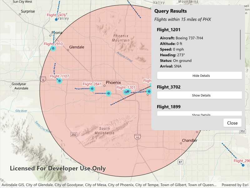
Developers can query a DynamicEntityDataSource to find dynamic entities that meet spatial and/or attribute criteria. The query returns a collection of dynamic entities matching the DynamicEntityQueryParameters at the moment the query is executed. An example of this is a flight tracking app that monitors airspace near a particular airport, allowing the user to monitor flights based on different criteria such as arrival airport or flight number.
How to use the sample
Tap the "Query Flights" button and select a query to perform from the menu. Once the query is complete, a list of the resulting flights will be displayed. Tap on a flight to see its latest attributes in real-time.
How it works
- Create a
DynamicEntityDataSourceto stream dynamic entity events. - Create a
DynamicEntityLayerusing the data source and add it to the map's operational layers. - Create
DynamicEntityQueryParametersand set its properties to specify the parameters for the query:- To spatially filter results, set the
geometryandspatialRelationship. The spatial relationship isintersectsby default. - To query entities with certain attribute values, set the
whereClause. - To get entities with specific track IDs, modify the
trackIDscollection.
- To spatially filter results, set the
- To perform a dynamic entities query, call
DynamicEntityDataSource.QueryDynamicEntitiesAsync()passing in the parameters. - When complete, iterate through the returned collection of
DynamicEntityobjects from the result. - Use the
DynamicEntity.DynamicEntityChangedevent to get real-time updates when entity attributes change. - Get the new observation from the resulting
DynamicEntityChangedEventArgsusing theReceivedObservationproperty to update the UI with current information.
Relevant API
- DynamicEntity
- DynamicEntityChangedInfo
- DynamicEntityDataSource
- DynamicEntityDataSourceInfo
- DynamicEntityLayer
- DynamicEntityObservation
- DynamicEntityQueryParameters
- DynamicEntityQueryResult
About the data
This sample uses the PHX Air Traffic JSON portal item, which is hosted on ArcGIS Online and downloaded automatically. The file contains JSON data for mock air traffic around the Phoenix Sky Harbor International Airport in Phoenix, AZ, USA. The decoded data is used to simulate dynamic entity events through a CustomDynamicEntityDataSource, which is displayed on the map with a DynamicEntityLayer.
Additional information
A dynamic entities query is performed on the most recent observation of each dynamic entity in the data source at the time the query is executed. As the dynamic entities change, they may no longer match the query parameters.
Tags
data, dynamic, entity, live, query, real-time, search, stream, track
Sample Code
// Copyright 2025 Esri.
//
// Licensed under the Apache License, Version 2.0 (the "License"); you may not use this file except in compliance with the License.
// You may obtain a copy of the License at: http://www.apache.org/licenses/LICENSE-2.0
//
// Unless required by applicable law or agreed to in writing, software distributed under the License is distributed on an
// "AS IS" BASIS, WITHOUT WARRANTIES OR CONDITIONS OF ANY KIND, either express or implied. See the License for the specific
// language governing permissions and limitations under the License.
using ArcGIS.Samples.Managers;
using Esri.ArcGISRuntime.ArcGISServices;
using Esri.ArcGISRuntime.Data;
using Esri.ArcGISRuntime.Geometry;
using Esri.ArcGISRuntime.Mapping;
using Esri.ArcGISRuntime.Mapping.Labeling;
using Esri.ArcGISRuntime.RealTime;
using Esri.ArcGISRuntime.Symbology;
using Esri.ArcGISRuntime.UI;
using System.Collections.ObjectModel;
using Map = Esri.ArcGISRuntime.Mapping.Map;
namespace ArcGIS.Samples.QueryDynamicEntities
{
[ArcGIS.Samples.Shared.Attributes.Sample(
name: "Query dynamic entities",
category: "Search",
description: "Find dynamic entities from a data source that match a query.",
instructions: "Tap the \"Query Flights\" button and select a query to perform from the menu. Once the query is complete, a list of the resulting flights will be displayed. Tap on a flight to see its latest attributes in real-time.",
tags: new[] { "data", "dynamic", "entity", "live", "query", "real-time", "search", "stream", "track" })]
[ArcGIS.Samples.Shared.Attributes.OfflineData("c78e297e99ad4572a48cdcd0b54bed30")]
public partial class QueryDynamicEntities : ContentPage
{
private CustomStreamService _dynamicEntityDataSource;
private DynamicEntityLayer _dynamicEntityLayer;
private GraphicsOverlay _bufferGraphicsOverlay;
private Geometry _phoenixAirportBuffer;
private ObservableCollection<FlightInfo> _queryResults;
private readonly MapPoint _phoenixAirport = new MapPoint(-112.0101, 33.4352, SpatialReferences.Wgs84);
private List<string> _queryOptions;
public QueryDynamicEntities()
{
InitializeComponent();
_ = Initialize();
}
private async Task Initialize()
{
try
{
// Create the map with a basemap and initial viewpoint.
MyMapView.Map = new Map(BasemapStyle.ArcGISTopographic);
await MyMapView.SetViewpointAsync(new Viewpoint(_phoenixAirport, 400000));
// Create and add a graphics overlay for the buffer around Phoenix Airport (PHX).
_bufferGraphicsOverlay = new GraphicsOverlay();
MyMapView.GraphicsOverlays.Add(_bufferGraphicsOverlay);
_phoenixAirportBuffer = GeometryEngine.BufferGeodetic(
_phoenixAirport, 15, LinearUnits.Miles, double.NaN, GeodeticCurveType.Geodesic);
// Create a semi-transparent fill symbol for the buffer area.
var bufferSymbol = new SimpleFillSymbol(
SimpleFillSymbolStyle.Solid,
System.Drawing.Color.FromArgb(40, 255, 0, 0),
new SimpleLineSymbol(SimpleLineSymbolStyle.Solid, System.Drawing.Color.Black, 1));
// Add the buffer graphic to the overlay and hide it initially.
_bufferGraphicsOverlay.Graphics.Add(new Graphic(_phoenixAirportBuffer, bufferSymbol));
_bufferGraphicsOverlay.IsVisible = false;
// Initialize the collection for query results and bind it to the results list.
_queryResults = new ObservableCollection<FlightInfo>();
ResultsList.ItemsSource = _queryResults;
// Set up the query options in the dropdown menu.
_queryOptions = new List<string>
{
"Within 15 Miles of PHX",
"Arriving in PHX",
"With Flight Number"
};
// Bind the query options to the dropdown and set initial visibility states.
QueryDropdown.ItemsSource = _queryOptions;
QueryDropdown.SelectedIndex = -1;
ResultsPanel.IsVisible = false;
FlightNumberDialog.IsVisible = false;
QueryDropdown.IsVisible = true;
// Create and configure the dynamic entity data source and layer.
await SetupDynamicEntityDataSource();
}
catch (Exception ex)
{
await DisplayAlert("Error", $"Error initializing sample: {ex.Message}", "OK");
}
}
// Creates and configures the dynamic entity data source and layer for real-time flight tracking.
private async Task SetupDynamicEntityDataSource()
{
try
{
// Define the fields expected in the dynamic entity data source.
var fields = new List<Field>
{
new Field(FieldType.Text, "flight_number", "", 50),
new Field(FieldType.Text, "aircraft", "", 50),
new Field(FieldType.Float64, "altitude_feet", "", 0),
new Field(FieldType.Text, "arrival_airport", "", 10),
new Field(FieldType.Float64, "heading", "", 0),
new Field(FieldType.Float64, "speed", "", 0),
new Field(FieldType.Text, "status", "", 50)
};
// Create the data source info with the unique track ID field and spatial reference.
var dataSourceInfo = new DynamicEntityDataSourceInfo("flight_number", fields)
{
SpatialReference = SpatialReferences.Wgs84
};
// Get the path to the JSON data file.
string dataPath = DataManager.GetDataFolder("c78e297e99ad4572a48cdcd0b54bed30", "phx_air_traffic.json");
// Initialize the custom stream service with the data source info and file path.
_dynamicEntityDataSource = new CustomStreamService(dataSourceInfo, dataPath, TimeSpan.FromMilliseconds(100));
// Create the dynamic entity layer with the data source and configure its display properties.
_dynamicEntityLayer = new DynamicEntityLayer(_dynamicEntityDataSource)
{
TrackDisplayProperties =
{
ShowPreviousObservations = true,
ShowTrackLine = true,
MaximumObservations = 20
}
};
// Define a simple marker symbol for the dynamic entities (flights).
var labelDefinition = new LabelDefinition(
new SimpleLabelExpression("[flight_number]"),
new TextSymbol
{
Color = System.Drawing.Color.Red,
Size = 12,
HaloColor = System.Drawing.Color.White,
HaloWidth = 2
})
{
Placement = LabelingPlacement.PointAboveCenter
};
// Create a simple marker symbol for the flights.
_dynamicEntityLayer.LabelDefinitions.Add(labelDefinition);
_dynamicEntityLayer.LabelsEnabled = true;
MyMapView.Map.OperationalLayers.Add(_dynamicEntityLayer);
await _dynamicEntityDataSource.ConnectAsync();
}
catch (Exception ex)
{
await DisplayAlert("Error", $"Error setting up data source: {ex.Message}", "OK");
}
}
// Handles query selection from dropdown and initiates appropriate query type.
private async void OnQuerySelectionChanged(object sender, EventArgs e)
{
if (QueryDropdown.SelectedIndex < 0)
return;
var selectedOption = QueryDropdown.SelectedItem as string;
if (string.IsNullOrEmpty(selectedOption))
return;
var queryType = selectedOption switch
{
"Within 15 Miles of PHX" => "QueryGeometry",
"Arriving in PHX" => "QueryAttributes",
"With Flight Number" => "QueryTrackId",
_ => null
};
if (string.IsNullOrEmpty(queryType))
return;
if (queryType == "QueryTrackId")
{
QueryDropdown.IsVisible = false;
FlightNumberDialog.IsVisible = true;
FlightNumberInput.Focus();
}
else
{
await PerformQuery(queryType);
}
}
// Processes flight number input and executes track ID query.
private async void OnFlightNumberQuery(object sender, EventArgs e)
{
var flightNumber = FlightNumberInput.Text?.Trim();
if (string.IsNullOrWhiteSpace(flightNumber))
{
await DisplayAlert("Input Required", "Please enter a flight number.", "OK");
return;
}
FlightNumberDialog.IsVisible = false;
QueryDropdown.IsVisible = false;
await PerformQuery("QueryTrackId", flightNumber);
FlightNumberInput.Text = string.Empty;
}
// Cancels flight number input and returns to query selection.
private void OnFlightNumberCancel(object sender, EventArgs e)
{
FlightNumberDialog.IsVisible = false;
FlightNumberInput.Text = string.Empty;
QueryDropdown.SelectedIndex = -1;
QueryDropdown.IsVisible = true;
}
// Toggles visibility of flight detail information in the results list.
private void OnToggleDetails(object sender, EventArgs e)
{
if (sender is Button button && button.BindingContext is FlightInfo flightInfo)
{
flightInfo.IsExpanded = !flightInfo.IsExpanded;
// On iOS, force the CollectionView to update its layout.
if (DeviceInfo.Platform == DevicePlatform.iOS)
{
// Add a small delay to ensure smooth animation.
Dispatcher.Dispatch(async () =>
{
await Task.Delay(10);
ResultsList.ScrollTo(flightInfo, position: ScrollToPosition.MakeVisible, animate: true);
});
}
}
}
// Executes the specified query type against the dynamic entity data source.
private async Task PerformQuery(string queryType, string flightNumber = null)
{
try
{
_queryResults.Clear();
if (_dynamicEntityLayer != null)
{
_dynamicEntityLayer.ClearSelection();
}
_bufferGraphicsOverlay.IsVisible = false;
if (_dynamicEntityDataSource == null || _dynamicEntityDataSource.ConnectionStatus != ConnectionStatus.Connected)
{
await DisplayAlert("Not Ready", "Data source is not connected. Please wait for the data to load.", "OK");
return;
}
// Set up query parameters based on the selected query type.
var queryParameters = new DynamicEntityQueryParameters();
switch (queryType)
{
// Query for entities within a 15-mile buffer of Phoenix Airport (PHX).
case "QueryGeometry":
queryParameters.Geometry = _phoenixAirportBuffer;
queryParameters.SpatialRelationship = SpatialRelationship.Intersects;
_bufferGraphicsOverlay.IsVisible = true;
ResultsDescription.Text = "Flights within 15 miles of PHX";
break;
// Query for entities with attributes indicating they are arriving at PHX.
case "QueryAttributes":
queryParameters.WhereClause = "status = 'In flight' AND arrival_airport = 'PHX'";
ResultsDescription.Text = "Flights arriving in PHX";
break;
// Query for a specific entity by its flight number (track ID).
case "QueryTrackId":
if (!string.IsNullOrEmpty(flightNumber))
{
queryParameters.TrackIds.Add(flightNumber);
ResultsDescription.Text = $"Flight {flightNumber}";
}
break;
default:
return;
}
IEnumerable<DynamicEntity> results = null;
// Execute the query against the dynamic entity data source.
if (_dynamicEntityLayer?.DataSource != null)
{
results = await _dynamicEntityLayer.DataSource.QueryDynamicEntitiesAsync(queryParameters);
}
results = results ?? Enumerable.Empty<DynamicEntity>();
// Process and display the query results.
if (results.Any())
{
foreach (var entity in results)
{
if (entity != null)
{
var flightNum = entity.Attributes["flight_number"]?.ToString();
if (!string.IsNullOrEmpty(flightNum))
{
_dynamicEntityLayer.SelectDynamicEntity(entity);
var flightInfo = new FlightInfo(entity);
_queryResults.Add(flightInfo);
}
}
}
}
// Update UI to show results and hide query options.
QueryDropdown.IsVisible = false;
ResultsPanel.IsVisible = true;
if (!_queryResults.Any())
{
await DisplayAlert("Live Tracking Active",
"No flights currently match the criteria, but the list will update as flights enter or leave the area.", "OK");
}
}
catch (Exception ex)
{
await DisplayAlert("Error", $"Query failed: {ex.Message}", "OK");
System.Diagnostics.Debug.WriteLine($"Query exception: {ex}");
}
}
// Centers the map view on the selected flight's current position.
private async void OnResultSelectionChanged(object sender, SelectionChangedEventArgs e)
{
if (e.CurrentSelection.FirstOrDefault() is FlightInfo flight && flight.Entity != null)
{
var latestObs = flight.Entity.GetLatestObservation();
if (latestObs?.Geometry is MapPoint point)
{
await MyMapView.SetViewpointCenterAsync(point, 50000);
}
}
}
// Closes the results panel and resets the UI to the initial state.
private void OnCloseResults(object sender, EventArgs e)
{
ResultsPanel.IsVisible = false;
QueryDropdown.IsVisible = true;
_queryResults.Clear();
if (_dynamicEntityLayer != null)
{
_dynamicEntityLayer.ClearSelection();
}
_bufferGraphicsOverlay.IsVisible = false;
QueryDropdown.SelectedIndex = -1;
}
}
}