Display an ArcGIS scene layer from a URL.
Use case
Adding a scene layer from a URL allows you to author the scene layer elsewhere in the platform, say with ArcGIS Pro or CityEngine, and then add that scene layer to a scene in ArcGIS Maps SDK. Loading a scene layer from a URL also permits the layer source to change dynamically without updating the code. Each scene layer added to a scene can assist in performing helpful visual analysis. For example, if presenting the results of a shadow analysis of a major metropolitan downtown area in 3D, adding a scene layer of 3D buildings to the scene that could be toggled on/off would help to better contextualize the source of the shadows.
How to use the sample
Pan and zoom to explore the scene.
How it works
- Create an
ArcGISSceneLayerpassing in the URL to a scene layer service. - Create a
Sceneand add the scene layer to its operational layers. - Create a
Surfaceobject and add anArcGISTiledElevationSourceto it. - Set the surface to the scene's base surface.
- Create a
SceneViewwith the scene.
Relevant API
- ArcGISSceneLayer
- ArcGISTiledElevationSource
- Scene
- SceneView
- Surface
About the data
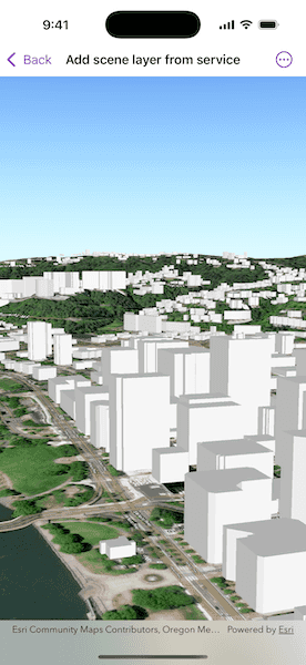
This sample shows a Portland, Oregon USA Scene hosted on ArcGIS Online.
Tags
3D, buildings, model, scene, service, URL
Sample Code
// Copyright 2022 Esri
//
// Licensed under the Apache License, Version 2.0 (the "License");
// you may not use this file except in compliance with the License.
// You may obtain a copy of the License at
//
// https://www.apache.org/licenses/LICENSE-2.0
//
// Unless required by applicable law or agreed to in writing, software
// distributed under the License is distributed on an "AS IS" BASIS,
// WITHOUT WARRANTIES OR CONDITIONS OF ANY KIND, either express or implied.
// See the License for the specific language governing permissions and
// limitations under the License.
import ArcGIS
import SwiftUI
struct AddSceneLayerFromServiceView: View {
/// A scene with an imagery basemap and a 3D buildings layer.
@State private var scene: ArcGIS.Scene = {
// Creates a scene layer using a URL to a scene layer service.
let sceneLayer = ArcGISSceneLayer(url: .portlandBuildingService)
// Creates a scene and adds the scene layer to its operational layers.
let scene = Scene(basemapStyle: .arcGISImagery)
scene.addOperationalLayer(sceneLayer)
// Creates an elevation source and adds it to the scene's base surface.
let elevationSource = ArcGISTiledElevationSource(url: .worldElevationService)
scene.baseSurface.addElevationSource(elevationSource)
// Sets the scene's initial viewpoint to center the scene view on the scene layer.
let point = Point(x: -122.66949, y: 45.51869, z: 227, spatialReference: .wgs84)
let camera = Camera(location: point, heading: 219, pitch: 82, roll: 0)
let viewpoint = Viewpoint(latitude: .nan, longitude: .nan, scale: .nan, camera: camera)
scene.initialViewpoint = viewpoint
return scene
}()
var body: some View {
// Displays the scene in a scene view.
SceneView(scene: scene)
}
}
private extension URL {
/// The URL of a scene service containing buildings in Portland, OR, USA.
static var portlandBuildingService: URL {
URL(string: "https://tiles.arcgis.com/tiles/P3ePLMYs2RVChkJx/arcgis/rest/services/Buildings_Portland/SceneServer")!
}
/// The URL of the Terrain 3D ArcGIS REST Service.
static var worldElevationService: URL {
URL(string: "https://elevation3d.arcgis.com/arcgis/rest/services/WorldElevation3D/Terrain3D/ImageServer")!
}
}
#Preview {
AddSceneLayerFromServiceView()
}