Use a geoprocessing service and a set of features to identify statistically significant hot spots and cold spots.
Use case
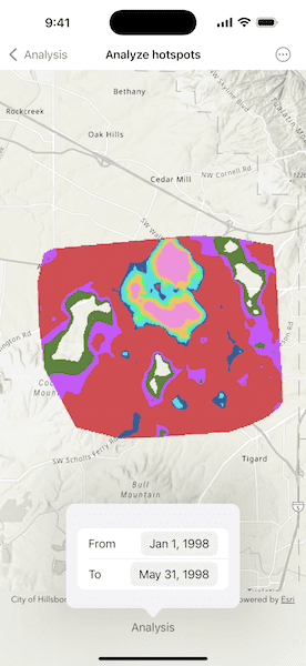
This tool identifies statistically significant spatial clusters of high values (hot spots) and low values (cold spots). For example, a hotspot analysis based on the frequency of 911 calls within a set region.
How to use the sample
Select a date range (between 1998-01-01 and 1998-05-31) from the dialog. The results will be shown on the map upon successful completion of the geoprocessing job.
How it works
- Create a geoprocessing task with the URL set to the endpoint of a geoprocessing service using
GeoprocessingTask.init(url:). - Create a query string with the date range and set it as an input of the geoprocessing parameters using
GeoprocessingParameters.setInputValue(_:forKey:). - Use the geoprocessing task to create a job with the parameters using
GeoprocessingTask.makeJob(parameters:). - Start the geoprocessing job and wait for it to complete and return a result using
GeoprocessingJob.output. - Get the resulting
ArcGISMapImageLayerinstance usingGeoprocessingResult.mapImageLayer. - Add the layer to the map's operational layers.
Relevant API
- GeoprocessingJob
- GeoprocessingParameters
- GeoprocessingResult
- GeoprocessingTask
Tags
analysis, density, geoprocessing, hot spots, hotspots
Sample Code
AnalyzeHotspotsView.swift
// Copyright 2025 Esri
//
// Licensed under the Apache License, Version 2.0 (the "License");
// you may not use this file except in compliance with the License.
// You may obtain a copy of the License at
//
// https://www.apache.org/licenses/LICENSE-2.0
//
// Unless required by applicable law or agreed to in writing, software
// distributed under the License is distributed on an "AS IS" BASIS,
// WITHOUT WARRANTIES OR CONDITIONS OF ANY KIND, either express or implied.
// See the License for the specific language governing permissions and
// limitations under the License.
import ArcGIS
import SwiftUI
struct AnalyzeHotspotsView: View {
/// The map displayed by the map view.
@State private var map: Map = {
let map = Map(basemapStyle: .arcGISTopographic)
map.initialViewpoint = Viewpoint(
center: Point(x: -13671170.647485, y: 5693633.356735, spatialReference: .webMercator),
scale: 57_779
)
return map
}()
/// The task used to perform geoprocessing jobs.
@State private var geoprocessingTask = GeoprocessingTask(
url: URL(string: "https://sampleserver6.arcgisonline.com/arcgis/rest/services/911CallsHotspot/GPServer/911%20Calls%20Hotspot")!
)
/// The error thrown by geoprocessing job.
@State private var analysisError: (any Error)?
/// A Boolean value indicating whether the geoprocessing job is running.
@State private var isAnalyzing = false
/// A Boolean value that indicates whether the analysis sheet is presented.
@State private var isAnalysisSheetPresented = false
/// The from date for the analysis.
@State private var fromDate = Self.minDate
/// The to date for the analysis.
@State private var toDate = Self.maxDate
/// The date range for the analysis.
var dateRange: ClosedRange<Date> { fromDate...toDate }
/// The minimum date for the analysis.
static var minDate: Date {
Calendar.current.date(from: DateComponents(year: 1998, month: 1, day: 1))!
}
/// The maximum date for the analysis.
static var maxDate: Date {
Calendar.current.date(from: DateComponents(year: 1998, month: 05, day: 31))!
}
var body: some View {
MapViewReader { mapView in
MapView(map: map)
.task(id: dateRange) {
map.removeAllOperationalLayers()
// Creates and configures the job's parameters.
let parameters = makeParameters(
spatialReference: map.spatialReference,
dateRange: dateRange
)
// Creates and runs the job.
let geoprocessingJob = geoprocessingTask.makeJob(parameters: parameters)
isAnalyzing = true
geoprocessingJob.start()
do {
let result = try await withTaskCancellationHandler {
try await geoprocessingJob.output
} onCancel: {
Task.detached {
await geoprocessingJob.cancel()
}
}
guard let mapImageLayer = result.mapImageLayer else {
return
}
try await mapImageLayer.load()
map.addOperationalLayer(mapImageLayer)
isAnalyzing = false
if let extent = mapImageLayer.fullExtent {
await mapView.setViewpointGeometry(extent)
}
} catch {
analysisError = error
}
}
.toolbar {
if isAnalyzing {
ToolbarItem(placement: .topBarTrailing) {
ProgressView()
.progressViewStyle(.circular)
}
}
ToolbarItem(placement: .bottomBar) {
Button("Analysis") {
isAnalysisSheetPresented.toggle()
}
.popover(isPresented: $isAnalysisSheetPresented) {
analysisForm
.frame(idealWidth: 250, idealHeight: 150)
.presentationCompactAdaptation(.popover)
}
}
}
.errorAlert(presentingError: $analysisError)
}
}
/// The form for customizing the analysis.
var analysisForm: some View {
Form {
Section {
let displayedComponents: DatePicker<Label>.Components = .date
DatePicker(
"From",
selection: $fromDate,
in: Self.minDate...toDate,
displayedComponents: displayedComponents
)
DatePicker(
"To",
selection: $toDate,
in: fromDate...Self.maxDate,
displayedComponents: displayedComponents
)
}
}
}
/// Creates the parameters for a geoprocessing job.
/// - Parameters:
/// - spatialReference: The process and output spatial reference.
/// - dateRange: The minimum and maximum dates.
/// - Returns: A new geoprocessing parameters object
func makeParameters(
spatialReference: SpatialReference?,
dateRange: ClosedRange<Date>
) -> GeoprocessingParameters {
// Creates the query string.
let format = Date.ISO8601FormatStyle()
.year()
.month()
.day()
let fromDateString = dateRange.lowerBound.formatted(format)
let toDateString = dateRange.upperBound.formatted(format)
let queryString = "(\"DATE\" > date '\(fromDateString) 00:00:00' AND \"DATE\" < date '\(toDateString) 00:00:00')"
// Creates and configures the parameters.
let parameters = GeoprocessingParameters(executionType: .asynchronousSubmit)
parameters.processSpatialReference = spatialReference
parameters.outputSpatialReference = spatialReference
parameters.setInputValue(GeoprocessingString(value: queryString), forKey: "Query")
return parameters
}
}
#Preview {
AnalyzeHotspotsView()
}