Display custom labels in a 3D scene.
Use case
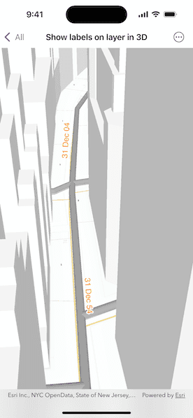
Labeling features is useful to visually display information or attributes on a scene. For example, city officials or maintenance crews may want to show installation dates of features of a gas network.
How to use the sample
Pan and zoom to explore the scene. Notice the labels showing installation dates of features in the 3D gas network.
How it works
- Create a scene from a
PortalItem. - Add the scene to a
SceneViewand load it. - After loading is complete, obtain the
FeatureLayerfrom one of theGroupLayers in the scene's operational layers. - Create a
TextSymbolto use for displaying the label text. - Create a
LabelDefinitionusing anArcadeLabelExpression. - Add the definition to the feature layer with
featureLayer.addLabelDefinition(labelDefinition). - Lastly, enable labels on the layer using
featureLayer.labelsAreEnabled.
Relevant API
- ArcadeLabelExpression
- FeatureLayer
- LabelDefinition
- Scene
- SceneView
- TextSymbol
About the data
This sample shows a New York City infrastructure scene hosted on ArcGIS Online.
Tags
3D, arcade, attribute, buildings, label, model, scene, symbol, text, URL, visualization
Sample Code
ShowLabelsOnLayerIn3DView.swift
// Copyright 2025 Esri
//
// Licensed under the Apache License, Version 2.0 (the "License");
// you may not use this file except in compliance with the License.
// You may obtain a copy of the License at
//
// https://www.apache.org/licenses/LICENSE-2.0
//
// Unless required by applicable law or agreed to in writing, software
// distributed under the License is distributed on an "AS IS" BASIS,
// WITHOUT WARRANTIES OR CONDITIONS OF ANY KIND, either express or implied.
// See the License for the specific language governing permissions and
// limitations under the License.
import ArcGIS
import SwiftUI
struct ShowLabelsOnLayerIn3DView: View {
/// A scene with a scene layer of utilities infrastructure in New York City.
@State private var scene: ArcGIS.Scene = Scene(
item: PortalItem(
portal: .arcGISOnline(connection: .anonymous),
id: .newYorkCityInfrastructure
)
)
/// The gas network feature layer on the scene.
private var gasFeatureLayer: FeatureLayer {
let groupLayer = scene.operationalLayers.first(where: { $0.name == "Gas" }) as! GroupLayer
return groupLayer.layers.first(where: { $0.name == "Gas Main" }) as! FeatureLayer
}
/// The error shown in the error alert.
@State private var error: (any Error)?
var body: some View {
SceneView(scene: scene)
.task {
do {
try await scene.load()
addLabels(to: gasFeatureLayer)
} catch {
self.error = error
}
}
.errorAlert(presentingError: $error)
}
}
private extension ShowLabelsOnLayerIn3DView {
/// Adds labels to a feature layer.
/// - Parameter layer: The `FeatureLayer` to add the labels to.
func addLabels(to layer: FeatureLayer) {
// Create a label definition.
let labelDefinition = makeLabelDefinition()
// Add label definition to the layer.
layer.addLabelDefinition(labelDefinition)
// Turn on labeling.
layer.labelsAreEnabled = true
}
/// Creates a label definition
func makeLabelDefinition() -> LabelDefinition {
// The styling for the label.
let textSymbol = TextSymbol(color: .orange, size: 16)
textSymbol.haloColor = .white
textSymbol.haloWidth = 2
// Make an arcade label expression.
let arcadeLabelExpression = ArcadeLabelExpression(arcadeString: "Text($feature.INSTALLATIONDATE, `DD MMM YY`)")
let labelDefinition = LabelDefinition(labelExpression: arcadeLabelExpression, textSymbol: textSymbol)
labelDefinition.placement = .lineAboveAlong
labelDefinition.usesCodedValues = true
return labelDefinition
}
}
private extension PortalItem.ID {
/// The ID to the "New York City infrastructure with 3D labels" web scene portal item on ArcGIS Online.
static var newYorkCityInfrastructure: Self { Self("850dfee7d30f4d9da0ebca34a533c169")! }
}
#Preview {
ShowLabelsOnLayerIn3DView()
}