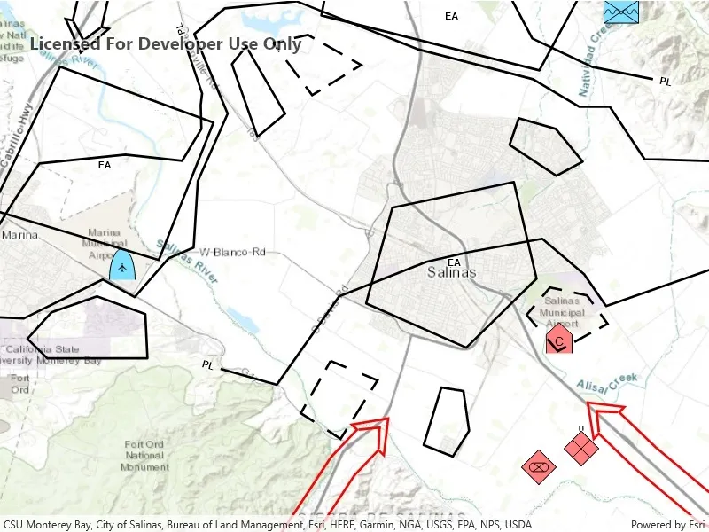
Convert features into graphics to show them with mil2525d symbols.
Use case
A dictionary renderer uses a style file along with a rule engine to display advanced symbology. This is useful for displaying features using precise military symbology.
How to use the sample
Pan and zoom around the map. Observe the displayed military symbology on the map.
How it works
- Create a
GeodatabaseusingGeodatabase(geodatabasePath). - Load the geodatabase asynchronously using
Geodatabase.LoadAsync(). - Instantiate a
SymbolDicitonaryusingSymbolDictionary(specificationType).specificationTypewill be the mil2525d.stylx file.
- Load the symbol dictionary asynchronously using
DictionarySymbol.LoadAsync(). - Wait for geodatabase to completely load.
- Cycle through each
GeodatabaseFeatureTablefrom the geodatabase usingGeodatabase.GeodatabaseFeatureTables. - Create a
FeatureLayerfrom each table within the geodatabase usingFeatureLayer(GeodatabaseFeatureTable). - Load the feature layer asynchronously with
FeatureLayer.LoadAsync(). - Wait for each layer to load.
- After the last layer has loaded, then create a new
Envelopefrom a union of the extents of all layers.- Set the envelope to be the
Viewpointof the map view usingMapView.SetViewpoint(new Viewpoint(Envelope)).
- Set the envelope to be the
- Add the feature layer to map using
Map.OperationalLayers.Add(FeatureLayer). - Create
DictionaryRenderer(SymbolDictionary)and attach to the feature layer.
Relevant API
- DictionaryRenderer
- SymbolDictionary
Offline data
This sample downloads the following items from ArcGIS Online automatically:
- mil2525d.stylx - A stylx file for building custom applications that incorporate the MIL-STD-2525D symbol dictionary.
- militaryoverlay.geodatabase.zip - This is a mobile geodatabase created from the Military Overlay template for use in ArcGIS Maps SDK for Native Apps samples
Tags
military, symbol
Sample code
// Copyright 2017 Esri.//// Licensed under the Apache License, Version 2.0 (the "License"); you may not use this file except in compliance with the License.// You may obtain a copy of the License at: http://www.apache.org/licenses/LICENSE-2.0//// Unless required by applicable law or agreed to in writing, software distributed under the License is distributed on an// "AS IS" BASIS, WITHOUT WARRANTIES OR CONDITIONS OF ANY KIND, either express or implied. See the License for the specific// language governing permissions and limitations under the License.
using ArcGIS.Samples.Managers;using Esri.ArcGISRuntime.Data;using Esri.ArcGISRuntime.Geometry;using Esri.ArcGISRuntime.Mapping;using Esri.ArcGISRuntime.Symbology;using System;using System.Threading.Tasks;
namespace ArcGIS.WinUI.Samples.FeatureLayerDictionaryRenderer{    [ArcGIS.Samples.Shared.Attributes.Sample(        name: "Dictionary renderer with feature layer",        category: "Layers",        description: "Convert features into graphics to show them with mil2525d symbols.",        instructions: "Pan and zoom around the map. Observe the displayed military symbology on the map.",        tags: new[] { "military", "symbol" })]    [ArcGIS.Samples.Shared.Attributes.OfflineData("c78b149a1d52414682c86a5feeb13d30", "e0d41b4b409a49a5a7ba11939d8535dc")]    public partial class FeatureLayerDictionaryRenderer    {        public FeatureLayerDictionaryRenderer()        {            InitializeComponent();
            // Setup the control references and execute initialization            _ = Initialize();        }
        private async Task Initialize()        {            // Create new Map with basemap            Map myMap = new Map(BasemapStyle.ArcGISTopographic);
            // Provide Map to the MapView            MyMapView.Map = myMap;
            // Get the path to the geodatabase            string geodbFilePath = GetGeodatabasePath();
            // Load the geodatabase from local storage            Geodatabase baseGeodatabase = await Geodatabase.OpenAsync(geodbFilePath);
            // Get the path to the symbol dictionary            string symbolFilepath = GetStyleDictionaryPath();
            try            {                // Load the symbol dictionary from local storage                DictionarySymbolStyle symbolStyle = await DictionarySymbolStyle.CreateFromFileAsync(symbolFilepath);
                // Add geodatabase features to the map, using the defined symbology                foreach (FeatureTable table in baseGeodatabase.GeodatabaseFeatureTables)                {                    // Load the table                    await table.LoadAsync();
                    // Create the feature layer from the table                    FeatureLayer myLayer = new FeatureLayer(table);
                    // Load the layer                    await myLayer.LoadAsync();
                    // Create a Dictionary Renderer using the DictionarySymbolStyle                    DictionaryRenderer dictRenderer = new DictionaryRenderer(symbolStyle);
                    // Apply the dictionary renderer to the layer                    myLayer.Renderer = dictRenderer;
                    // Add the layer to the map                    myMap.OperationalLayers.Add(myLayer);                }
                // Create geometry for the center of the map                MapPoint centerGeometry = new MapPoint(-13549402.587055, 4397264.96879385, SpatialReference.Create(3857));
                // Set the map's viewpoint to highlight the desired content                MyMapView.SetViewpoint(new Viewpoint(centerGeometry, 201555));            }            catch (Exception e)            {                await new MessageDialog2(e.ToString(), "Error").ShowAsync();            }        }
        // Get the file path for the style dictionary        private static string GetStyleDictionaryPath()        {            return DataManager.GetDataFolder("c78b149a1d52414682c86a5feeb13d30", "mil2525d.stylx");        }
// Get the file path for the geodatabase private static string GetGeodatabasePath() { return DataManager.GetDataFolder("e0d41b4b409a49a5a7ba11939d8535dc", "militaryoverlay.geodatabase"); } }}<UserControl x:Class="ArcGIS.WinUI.Samples.FeatureLayerDictionaryRenderer.FeatureLayerDictionaryRenderer" xmlns="http://schemas.microsoft.com/winfx/2006/xaml/presentation" xmlns:x="http://schemas.microsoft.com/winfx/2006/xaml" xmlns:esriUI="using:Esri.ArcGISRuntime.UI.Controls"> <Grid> <esriUI:MapView x:Name="MyMapView" /> </Grid></UserControl>