Display a file with a KML network link, including displaying any network link control messages at launch.
Use case
KML files can reference other KML files on the network and support automatically refreshing content. For example, survey workers will benefit from KML data shown on their devices automatically refreshing to show the most up-to-date state. Additionally, discovering KML files linked to the data they are currently viewing provides additional information to make better decisions in the field.
How to use the sample
The sample will load the KML file automatically. The data shown should refresh automatically every few seconds. Pan and zoom to explore the map.
How it works
- Create a
KmlDatasetfrom a KML source which has network links. - Construct a
KmlLayerwith the dataset and add the layer as an operational layer. - To listen for network messages, add an event handler to the
NetworkLinkControlMessageevent on the dataset.
Relevant API
- KmlDataset
- KmlDataset.NetworkLinkControlMessage
- KmlLayer
- KmlNetworkLinkControlMessageEventArgs
Offline data
This sample uses the radar.kmz file, which can be found on ArcGIS Online.
About the data
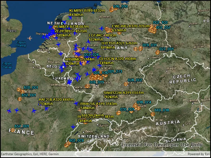
This map shows the current air traffic in parts of Europe with heading, altitude, and ground speed. Additionally, noise levels from ground monitoring stations are shown.
Tags
Keyhole, KML, KMZ, Network Link, Network Link Control, OGC
Sample code
// Copyright 2018 Esri.//// Licensed under the Apache License, Version 2.0 (the "License"); you may not use this file except in compliance with the License.// You may obtain a copy of the License at: http://www.apache.org/licenses/LICENSE-2.0//// Unless required by applicable law or agreed to in writing, software distributed under the License is distributed on an// "AS IS" BASIS, WITHOUT WARRANTIES OR CONDITIONS OF ANY KIND, either express or implied. See the License for the specific// language governing permissions and limitations under the License.
using Esri.ArcGISRuntime.Geometry;using Esri.ArcGISRuntime.Mapping;using Esri.ArcGISRuntime.Ogc;using System;
namespace ArcGIS.WinUI.Samples.DisplayKmlNetworkLinks{    [ArcGIS.Samples.Shared.Attributes.Sample(        name: "Display KML network links",        category: "Layers",        description: "Display a file with a KML network link, including displaying any network link control messages at launch.",        instructions: "The sample will load the KML file automatically. The data shown should refresh automatically every few seconds. Pan and zoom to explore the map.",        tags: new[] { "KML", "KMZ", "Keyhole", "Network Link", "Network Link Control", "OGC" })]    public partial class DisplayKmlNetworkLinks    {        public DisplayKmlNetworkLinks()        {            InitializeComponent();            Initialize();        }
        private void Initialize()        {            // Set up the basemap.            MySceneView.Scene = new Scene(BasemapStyle.ArcGISImagery);
            // Create the dataset.            KmlDataset dataset = new KmlDataset(new Uri("https://www.arcgis.com/sharing/rest/content/items/600748d4464442288f6db8a4ba27dc95/data"));
            // Listen for network link control messages.            // These should be shown to the user.            dataset.NetworkLinkControlMessage += Dataset_NetworkLinkControlMessage;
            // Create the layer from the dataset.            KmlLayer fileLayer = new KmlLayer(dataset);
            // Add the layer to the map.            MySceneView.Scene.OperationalLayers.Add(fileLayer);
            // Zoom in to center the map on Germany.            MySceneView.SetViewpoint(new Viewpoint(new MapPoint(8.150526, 50.472421, SpatialReferences.Wgs84), 20000000));        }
private void Dataset_NetworkLinkControlMessage(object sender, KmlNetworkLinkControlMessageEventArgs e) { // Due to the nature of the threading implementation, // the dispatcher needs to be used to interact with the UI. // The dispatcher takes an Action, provided here as a lambda function. DispatcherQueue.TryEnqueue(Microsoft.UI.Dispatching.DispatcherQueuePriority.Normal, () => { _ = new MessageDialog2(e.Message, "KML layer message").ShowAsync(); }); } }}<UserControl x:Class="ArcGIS.WinUI.Samples.DisplayKmlNetworkLinks.DisplayKmlNetworkLinks" xmlns="http://schemas.microsoft.com/winfx/2006/xaml/presentation" xmlns:x="http://schemas.microsoft.com/winfx/2006/xaml" xmlns:esriUI="using:Esri.ArcGISRuntime.UI.Controls"> <Grid> <esriUI:SceneView x:Name="MySceneView" /> </Grid></UserControl>