Display custom labels in a 3D scene.
Use case
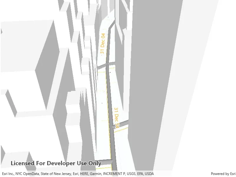
Labeling features is useful to visually display information or attributes on a scene. For example, city officials or maintenance crews may want to show installation dates of features of a gas network.
How to use the sample
Pan and zoom to explore the scene. Notice the labels showing installation dates of features in the 3D gas network.
How it works
To open a web scene from a portal item:
- Create a
Scenefrom a URL, then load. - After loading is complete, obtain the gas layer from the scene’s operational layers.
- From the gas layer, find the main gas sublayer.
- Create a
TextSymbolto use for displaying the label text. - Create a
LabelDefinitionusing anArcadeLabelExpression. - Add the definition to the feature layer’s
labelDefinitionslist.
Relevant API
- ArcadeLabelExpression
- LabelDefinition
- Scene
- SceneView
About the data
This sample shows a New York City infrastructure scene hosted on ArcGIS Online.
Tags
3D, labeling, scene, web scene
Sample code
// Copyright 2022 Esri.//// Licensed under the Apache License, Version 2.0 (the "License"); you may not use this file except in compliance with the License.// You may obtain a copy of the License at: http://www.apache.org/licenses/LICENSE-2.0//// Unless required by applicable law or agreed to in writing, software distributed under the License is distributed on an// "AS IS" BASIS, WITHOUT WARRANTIES OR CONDITIONS OF ANY KIND, either express or implied. See the License for the specific// language governing permissions and limitations under the License.
using Esri.ArcGISRuntime.Mapping;using Esri.ArcGISRuntime.Mapping.Labeling;using Esri.ArcGISRuntime.Symbology;using System;using System.Linq;using System.Threading.Tasks;
namespace ArcGIS.WinUI.Samples.ShowLabelsOnLayer3D{    [ArcGIS.Samples.Shared.Attributes.Sample(        name: "Show labels on layer 3D",        category: "Scene",        description: "Display custom labels in a 3D scene.",        instructions: "Pan and zoom to explore the scene. Notice the labels showing installation dates of features in the 3D gas network.",        tags: new[] { "3D", "labeling", "scene", "web scene" })]    public partial class ShowLabelsOnLayer3D    {        // Store the link to the web scene.        private const string ItemUrl = "https://www.arcgis.com/home/item.html?id=850dfee7d30f4d9da0ebca34a533c169";
        public ShowLabelsOnLayer3D()        {            InitializeComponent();            _ = Initialize();        }
        private async Task Initialize()        {            try            {                // Set the scene from a web scene.                MySceneView.Scene = new Scene(new Uri(ItemUrl));
                // Load scene to access properties.                await MySceneView.Scene.LoadAsync();
                // Find the gas layer, then the gas sublayer.                Layer gasLayer = MySceneView.Scene.OperationalLayers.Single(l => l.Name.Equals("Gas"));                FeatureLayer gasMainLayer = gasLayer.SublayerContents.Single(l => l.Name.Equals("Gas Main")) as FeatureLayer;
                gasMainLayer.LabelDefinitions.Clear();
                gasMainLayer.LabelsEnabled = true;
                // Create a text symbol for the label definition.                var textSymbol = new TextSymbol                {                    Color = System.Drawing.Color.Orange,                    HaloColor = System.Drawing.Color.White,                    HaloWidth = 2,                    Size = 16                };
                // Create a label defintion from an arcade label expression and the text symbol.                var labelDefinition = new LabelDefinition(new ArcadeLabelExpression("Text($feature.INSTALLATIONDATE, `DD MMM YY`)"),                    textSymbol);
gasMainLayer.LabelDefinitions.Add(labelDefinition); } catch (Exception e) { await new MessageDialog2(e.ToString(), "Error").ShowAsync(); } } }}<UserControl x:Class="ArcGIS.WinUI.Samples.ShowLabelsOnLayer3D.ShowLabelsOnLayer3D" xmlns="http://schemas.microsoft.com/winfx/2006/xaml/presentation" xmlns:x="http://schemas.microsoft.com/winfx/2006/xaml" xmlns:esriUI="using:Esri.ArcGISRuntime.UI.Controls">
<esriUI:SceneView x:Name="MySceneView" />
</UserControl>