Add, remove, and reorder operational layers in a map.
Use case
Operational layers display the primary content of the map and usually provide dynamic content for the user to interact with (as opposed to basemap layers that provide context).
The order of operational layers in a map determines the visual hierarchy of layers in the view. You can bring attention to a specific layer by rendering above other layers.
How to use the sample
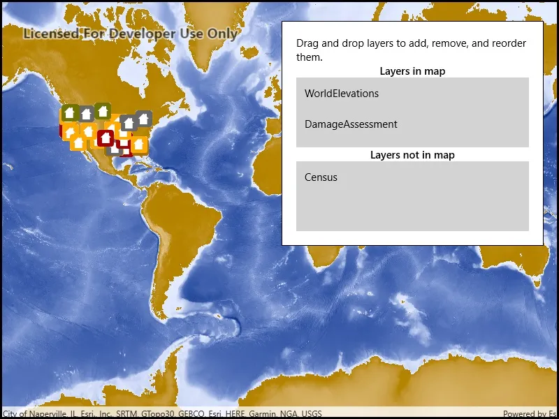
When the app starts, a list displays the operational layers that are currently displayed in the map. Right-click on the list item to remove the layer, or left-click to move it to the top. The map will be updated automatically.
The second list shows layers that have been removed from the map. Click one to add it to the map.
How it works
- Get the operational layers from the map using
map.OperationalLayers. - Add or remove layers using
layerList.Add(layer)andlayerList.Remove(layer)respectively. The last layer in the list will be rendered on top.
Relevant API
- ArcGISMapImageLayer
- Map
- MapView
- MapView.OperationalLayers
Additional information
You cannot add the same layer to the map multiple times or add the same layer to multiple maps. Instead, create a new layer using the FeatureTable.
Tags
add, delete, layer, map, remove
Sample code
// Copyright 2019 Esri.//// Licensed under the Apache License, Version 2.0 (the "License"); you may not use this file except in compliance with the License.// You may obtain a copy of the License at: http://www.apache.org/licenses/LICENSE-2.0//// Unless required by applicable law or agreed to in writing, software distributed under the License is distributed on an// "AS IS" BASIS, WITHOUT WARRANTIES OR CONDITIONS OF ANY KIND, either express or implied. See the License for the specific// language governing permissions and limitations under the License.
using Esri.ArcGISRuntime.Mapping;using Microsoft.UI.Xaml;using Microsoft.UI.Xaml.Controls;using System;using System.Collections.Generic;using System.Diagnostics;using System.Linq;using Windows.ApplicationModel.DataTransfer;
namespace ArcGIS.WinUI.Samples.ManageOperationalLayers{    [ArcGIS.Samples.Shared.Attributes.Sample(        name: "Manage operational layers",        category: "Map",        description: "Add, remove, and reorder operational layers in a map.",        instructions: "When the app starts, a list displays the operational layers that are currently displayed in the map. Right-click on the list item to remove the layer, or left-click to move it to the top. The map will be updated automatically.",        tags: new[] { "add", "delete", "layer", "map", "remove" })]    public partial class ManageOperationalLayers    {        // The view model manages the data for the sample.        private MapViewModel _viewModel;
        // Hold a reference to the originating listview when dragging and dropping.        private ListView _originListView;
        // Some URLs of layers to add to the map.        private readonly string[] _layerUrls = new[]        {            "http://sampleserver5.arcgisonline.com/arcgis/rest/services/Elevation/WorldElevations/MapServer",            "http://sampleserver5.arcgisonline.com/arcgis/rest/services/Census/MapServer",            "http://sampleserver5.arcgisonline.com/arcgis/rest/services/DamageAssessment/MapServer"        };
        public ManageOperationalLayers()        {            InitializeComponent();            Initialize();        }
        private void Initialize()        {            _viewModel = new MapViewModel(new Map(BasemapStyle.ArcGISStreets));
            // Configure the bindings to point to the view model.            this.DataContext = _viewModel;
            // Add the layers.            foreach (string layerUrl in _layerUrls)            {                _viewModel.AddLayerFromUrl(layerUrl);            }        }
        private void ListBox_OnDragOver(object sender, DragEventArgs e)        {            // Specify that the listview accepts dropping and that the operation is a move (rather than a copy or link)            e.AcceptedOperation = DataPackageOperation.Move;        }
        private void ListBox_OnDrop(object sender, DragEventArgs e)        {            // If the item being dropped is a layer...            if (e.DataView != null && e.DataView.Properties != null && e.DataView.Properties.Any(x => x.Key == "item" && x.Value is Layer))            {                try                {                    // Start doing work for the drop.                    DragOperationDeferral deferral = e.GetDeferral();
                    // Get the layer that is being moved.                    KeyValuePair<string, object> draggedItem = e.Data.Properties.FirstOrDefault(x => x.Key == "item");                    Layer draggedLayer = draggedItem.Value as Layer;
                    // Find the source and destination views.                    ListView destinationList = sender as ListView;                    ListView sourceList = _originListView;
                    // Remove the layer and re-add it.                    ((LayerCollection)sourceList.ItemsSource).Remove(draggedLayer);                    ((LayerCollection)destinationList.ItemsSource).Add(draggedLayer);
                    // Finish the drop.                    deferral.Complete();                }                catch (Exception ex)                {                    Debug.WriteLine(ex.ToString());                }            }            else            {                // Don't allow other things to be dropped (e.g. files from the desktop).                e.AcceptedOperation = DataPackageOperation.None;            }        }
        private void ListBox_OnDragItemsStarting(object sender, DragItemsStartingEventArgs e)        {            // Store the originating list view for the drag operation.            _originListView = sender as ListView;
            // Specify the type of drag and drop.            e.Data.RequestedOperation = DataPackageOperation.Move;
            if (e.Items != null && e.Items.Any())            {                // Store the layer in the data package.                e.Data.Properties.Add("item", e.Items.FirstOrDefault());            }        }    }
    internal class MapViewModel    {        public Map Map { get; }        public LayerCollection IncludedLayers => Map.OperationalLayers;        public LayerCollection ExcludedLayers { get; } = new LayerCollection();
        public MapViewModel(Map map)        {            Map = map;        }
public void AddLayerFromUrl(string layerUrl) { ArcGISMapImageLayer layer = new ArcGISMapImageLayer(new Uri(layerUrl)); Map.OperationalLayers.Add(layer); } }}<UserControl x:Class="ArcGIS.WinUI.Samples.ManageOperationalLayers.ManageOperationalLayers" xmlns="http://schemas.microsoft.com/winfx/2006/xaml/presentation" xmlns:x="http://schemas.microsoft.com/winfx/2006/xaml" xmlns:esriUI="using:Esri.ArcGISRuntime.UI.Controls"> <UserControl.Resources> <DataTemplate x:Key="LayerItemTemplate"> <TextBlock Text="{Binding Name}" /> </DataTemplate> <Style x:Key="LayerListStyle" TargetType="ListView"> <Setter Property="Background" Value="LightGray" /> <Setter Property="MinHeight" Value="100" /> <Setter Property="HorizontalAlignment" Value="Stretch" /> <!-- Allow items to be dropped on the listview. --> <Setter Property="AllowDrop" Value="True" /> <!-- Allow items to be dragged out of the listview. --> <Setter Property="CanDragItems" Value="True" /> <!-- Allow items to be reordered within the listview --> <Setter Property="CanReorderItems" Value="True" /> </Style> </UserControl.Resources> <Grid> <esriUI:MapView Map="{Binding Map}" /> <Border Style="{StaticResource BorderStyle}"> <StackPanel Orientation="Vertical"> <TextBlock Text="Drag and drop layers to add, remove, and reorder them." TextAlignment="Left" TextWrapping="Wrap" /> <TextBlock FontWeight="SemiBold" Text="Layers in map" TextAlignment="Center" /> <!-- Item template defined in UserControl.Resources above specifies that each listbox item's content consists of a label with the layer's Name property displayed. --> <ListView DragItemsStarting="ListBox_OnDragItemsStarting" DragOver="ListBox_OnDragOver" Drop="ListBox_OnDrop" ItemTemplate="{StaticResource LayerItemTemplate}" ItemsSource="{Binding IncludedLayers, Mode=TwoWay}" Style="{StaticResource LayerListStyle}" /> <TextBlock FontWeight="SemiBold" Text="Layers not in map" TextAlignment="Center" /> <!-- Item template defined in UserControl.Resources above specifies that each listbox item's content consists of a label with the layer's Name property displayed. --> <ListView DragItemsStarting="ListBox_OnDragItemsStarting" DragOver="ListBox_OnDragOver" Drop="ListBox_OnDrop" ItemTemplate="{StaticResource LayerItemTemplate}" ItemsSource="{Binding ExcludedLayers}" Style="{StaticResource LayerListStyle}" /> </StackPanel> </Border> </Grid></UserControl>