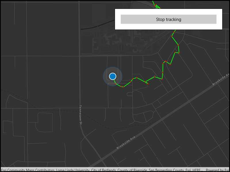
Display your location history on the map.
Use case
You can track device location history and display it as lines and points on the map. The history can be used to visualize how the user moved through the world, to retrace their steps, or to create new feature geometry. An unmapped trail, for example, could be added to the map using this technique.
How to use the sample
Click 'Start tracking' to start tracking your location, which will appear as points on the map. A line will connect the points for easier visualization. Click 'Stop tracking' to stop updating the location history. This sample uses a simulated data source to allow the sample to be useful on desktop/non-mobile devices. To track a user's real position, use the SystemLocationDataSource instead.
How it works
- If necessary, request location permission from the operating system.
- Create a graphics overlay to show each point and another graphics overlay for displaying the route line.
- Create a
SimulatedLocationDataSourceand initialize it with a polyline. Start theSimulatedLocationDataSourceto begin receiving location updates.
- NOTE: To track a user's real position, use
SystemLocationDataSourceinstead.
- Subscribe to the
LocationChangedevent to handle location updates. - Every time the location updates, store that location, display a point on the map, and recreate the route line.
Relevant API
- Location.Position
- LocationDataSource
- LocationDataSource.LocationChanged
- LocationDataSource.UpdateLocation
- LocationDisplay.AutoPanMode
- LocationDisplay.DataSource
- LocationDisplay.IsEnabled
- MapView.LocationDisplay
- SimulatedLocationDataSource
About the data
A custom set of points is used to create a Polyline and initialize a SimulatedLocationDataSource. This simulated location data source enables easier testing and allows the sample to be used on devices without an actively updating GPS signal.
Tags
bread crumb, breadcrumb, GPS, history, movement, navigation, real-time, trace, track, trail
Sample Code
// Copyright 2020 Esri.
//
// Licensed under the Apache License, Version 2.0 (the "License"); you may not use this file except in compliance with the License.
// You may obtain a copy of the License at: http://www.apache.org/licenses/LICENSE-2.0
//
// Unless required by applicable law or agreed to in writing, software distributed under the License is distributed on an
// "AS IS" BASIS, WITHOUT WARRANTIES OR CONDITIONS OF ANY KIND, either express or implied. See the License for the specific
// language governing permissions and limitations under the License.
using Esri.ArcGISRuntime.Geometry;
using Esri.ArcGISRuntime.Location;
using Esri.ArcGISRuntime.Mapping;
using Esri.ArcGISRuntime.Symbology;
using Esri.ArcGISRuntime.UI;
using Microsoft.UI.Xaml;
using System;
using System.Threading.Tasks;
namespace ArcGIS.WinUI.Samples.ShowLocationHistory
{
[ArcGIS.Samples.Shared.Attributes.Sample(
name: "Show location history",
category: "Location",
description: "Display your location history on the map.",
instructions: "Click 'Start tracking' to start tracking your location, which will appear as points on the map. A line will connect the points for easier visualization. Click 'Stop tracking' to stop updating the location history. This sample uses a simulated data source to allow the sample to be useful on desktop/non-mobile devices. To track a user's real position, use the `SystemLocationDataSource` instead.",
tags: new[] { "GPS", "bread crumb", "breadcrumb", "history", "movement", "navigation", "real-time", "trace", "track", "trail" })]
public partial class ShowLocationHistory
{
// Track whether location tracking is enabled.
private bool _isTrackingEnabled;
// Location data source provides location data updates.
private LocationDataSource _locationDataSource;
// Graphics overlay to display the location history (points).
private GraphicsOverlay _locationHistoryOverlay;
// Graphics overlay to display the line created by the location points.
private GraphicsOverlay _locationHistoryLineOverlay;
// Polyline builder to more efficiently manage large location history graphic.
private PolylineBuilder _polylineBuilder;
// Track previous location to ensure the route line appears behind the animating location symbol.
private MapPoint _lastPosition;
public ShowLocationHistory()
{
InitializeComponent();
Initialize();
}
private void Initialize()
{
// Add event handler for when this sample is unloaded.
Unloaded += SampleUnloaded;
// Create new Map with basemap.
Map myMap = new Map(BasemapStyle.ArcGISDarkGray);
// Display the map.
MyMapView.Map = myMap;
// Create and add graphics overlay for displaying the trail.
_locationHistoryLineOverlay = new GraphicsOverlay();
SimpleLineSymbol locationLineSymbol = new SimpleLineSymbol(SimpleLineSymbolStyle.Solid, System.Drawing.Color.Lime, 2);
_locationHistoryLineOverlay.Renderer = new SimpleRenderer(locationLineSymbol);
MyMapView.GraphicsOverlays.Add(_locationHistoryLineOverlay);
// Create and add graphics overlay for showing points.
_locationHistoryOverlay = new GraphicsOverlay();
SimpleMarkerSymbol locationPointSymbol = new SimpleMarkerSymbol(SimpleMarkerSymbolStyle.Circle, System.Drawing.Color.Red, 3);
_locationHistoryOverlay.Renderer = new SimpleRenderer(locationPointSymbol);
MyMapView.GraphicsOverlays.Add(_locationHistoryOverlay);
// Create the polyline builder.
_polylineBuilder = new PolylineBuilder(SpatialReferences.WebMercator);
// Start location services.
_ = HandleLocationReady();
}
private async Task HandleLocationReady()
{
// Create a polyline of mock data.
var simulatedLocations = (Polyline)Geometry.FromJson("{\"paths\":[[[-13185646.046666779,4037971.5966668758],[-13185586.780000051,4037827.6633333955], [-13185514.813333312,4037709.1299999417],[-13185569.846666701,4037522.8633330846], [-13185591.01333339,4037378.9299996048],[-13185629.113333428,4037283.6799995075], [-13185770.93000024,4037425.4966663187],[-13185821.730000293,4037546.146666442], [-13185880.996667018,4037704.8966666036],[-13185948.730000421,4037874.2300001099], [-13185974.130000448,4037946.1966668498],[-13186120.180000596,4037958.896666863], [-13186264.113334076,4037984.296666889],[-13186336.080000836,4038001.2300002342], [-13186314.91333415,4037757.8133333195],[-13186272.580000773,4037560.9633331187], [-13186187.913334005,4037463.59666635],[-13186431.33000092,4037404.3299996229], [-13186676.863334503,4037290.0299995062],[-13187625.130002158,4038589.6633341513], [-13187333.030001862,4038756.8800009824],[-13187091.730001617,4038617.1800008402], [-13186791.163334643,4038805.5633343654],[-13186721.313334571,4038801.3300010278], [-13186833.49666802,4038195.9633337436],[-13186977.677439401,4037699.8176972247], [-13186784.921301765,4037820.4541915278],[-13186749.517113185,4038150.8932846226], [-13186649.860878762,4038288.5762400767],[-13186556.760975549,4038323.9804286221], [-13186472.839936033,4038481.3323777127],[-13186373.183701571,4038489.1999751539], [-13186344.335844241,4038242.6819215398],[-13186126.665647998,4038308.245233661], [-13185814.584282301,4038358.0733508728],[-13185651.987268206,4038116.8003622484], [-13185203.534213299,4038048.6145176427],[-13184576.748949422,4038150.8932845518], [-13184251.55492135,4037833.5668537691],[-13184146.653621957,4037524.1080205571], [-13183949.963685593,4037621.1417224966],[-13183687.71043711,4037781.1162040718], [-13183480.530370807,4037875.5273735262],[-13182307.629999243,4037859.7460188437], [-13181376.039484169,4037820.9297473822],[-13180716.162869323,4038364.3575478429], [-13180182.439136729,4038810.7446696493],[-13178474.523192419,4040237.2426458625], [-13178321.134040033,4039740.6894803117],[-13177958.020228144,4039140.1550991111], [-13177073.512224896,4037459.5898928214],[-13177757.842101147,4037589.9384406791], [-13178386.308314031,4037799.427178307],[-13180095.012208173,4037811.6550856642], [-13180126.165447287,4036845.9046731163],[-13179806.844746364,4036324.0879179495], [-13180928.361354485,4035887.9425703473],[-13181598.155995468,4035428.432293402], [-13182984.47513606,4034447.105261297],[-13182229.264383668,4033222.8051626245], [-13182058.735615831,4033339.8690072047],[-13181939.035180708,4033691.2477038498], [-13182116.65518121,4033861.1450956347],[-13181792.305615077,4034085.1007484416], [-13182027.845180977,4034467.3698799671],[-13181877.254310986,4034644.9898804692], [-13181630.130832028,4034517.5668366305],[-13181386.868657427,4034424.8955320208], [-13181228.555178719,4034652.7124891868],[-13181379.14604871,4034942.3103160923], [-13181267.168222306,4035189.4337950516],[-13181074.103004368,4035015.6750989081], [-13180807.673003616,4034934.5877073747],[-13180618.469090037,4034814.8872722536], [-13180599.162568243,4035374.7764042714],[-13181047.073873857,4035494.476839392], [-13181317.365178969,4035413.3894478586],[-13180765.198655669,4035143.0981427468], [-13180328.871263131,4034892.1133594285],[-13180270.951697765,4035258.9372735149], [-13180325.009958787,4035718.4324922049],[-13180707.279090302,4035695.2646660525], [-13181413.897788007,4035536.9511873648],[-13181618.54691902,4035807.2424924765], [-13181884.976919774,4036065.949884512],[-13182159.129529245,4035861.3007534989], [-13182174.57474668,4035668.2355355616],[-13182417.83692128,4035664.374231203], [-13182784.660835361,4035409.5281435261],[-13182997.032575091,4035255.0759691764], [-13182618.624747934,4034679.7416197238]]], \"spatialReference\":{\"wkid\":102100,\"latestWkid\":3857}}");
// Create a simulated location data source using the mock data.
var parameters = new SimulationParameters(DateTimeOffset.Now, 150);
var simulatedSource = new SimulatedLocationDataSource();
simulatedSource.SetLocationsWithPolyline(simulatedLocations, parameters);
// Set the location data source to the simulated source.
_locationDataSource = simulatedSource;
// Use this instead if you want real location: _locationDataSource = new SystemLocationDataSource();
try
{
// Start the data source.
await _locationDataSource.StartAsync();
if (_locationDataSource.Status == LocationDataSourceStatus.Started)
{
// Set the location display data source and enable location display.
MyMapView.LocationDisplay.DataSource = _locationDataSource;
MyMapView.LocationDisplay.IsEnabled = true;
MyMapView.LocationDisplay.AutoPanMode = LocationDisplayAutoPanMode.Recenter;
MyMapView.LocationDisplay.InitialZoomScale = 10000;
// Enable the button to start location tracking.
LocationTrackingButton.IsEnabled = true;
}
else
{
ShowMessage("There was a problem enabling location", "Error");
}
}
catch (Exception e)
{
System.Diagnostics.Debug.WriteLine(e);
ShowMessage("There was a problem enabling location", "Error");
}
}
private void ToggleLocationTracking()
{
// Toggle location tracking.
_isTrackingEnabled = !_isTrackingEnabled;
// Apply new configuration.
if (_isTrackingEnabled)
{
// Configure new symbology first.
_locationDataSource.LocationChanged += LocationDataSourceOnLocationChanged;
// Update the UI.
LocationTrackingButton.Content = "Stop tracking";
}
else
{
// Stop updating.
_locationDataSource.LocationChanged -= LocationDataSourceOnLocationChanged;
// Update the UI.
LocationTrackingButton.Content = "Start tracking";
}
}
private void LocationDataSourceOnLocationChanged(object sender, Location e)
{
// Remove the old line.
_locationHistoryLineOverlay.Graphics.Clear();
// Add any previous position to the history.
if (_lastPosition != null)
{
_polylineBuilder.AddPoint(_lastPosition);
_locationHistoryOverlay.Graphics.Add(new Graphic(_lastPosition));
}
// Store the current position.
_lastPosition = e.Position;
// Add the updated line.
_locationHistoryLineOverlay.Graphics.Add(new Graphic(_polylineBuilder.ToGeometry()));
}
private void LocationTrackingButton_OnClick(object sender, RoutedEventArgs e) => ToggleLocationTracking();
private void ShowMessage(string title, string detail)
{
_ = new MessageDialog2(detail, title).ShowAsync();
}
private void SampleUnloaded(object sender, RoutedEventArgs e)
{
// Stop the location data source.
MyMapView.LocationDisplay?.DataSource?.StopAsync();
}
}
}