Sites
The blog articles referenced in this page are also available via the
ArcGIS Blog: JavaScript
, mostly focused on the
Latest blogs

Retirement of custom widgets in ArcGIS Experience Builder built with Maps SDK for JavaScript
ArcGIS Experience Builder custom built widgets using ArcGIS Maps SDK for JavaScript widgets will retire in Q1 …

Federal Technical Webinar Series
Register for this technical webinar series designed specifically for federal government professionals who rely on …

All things Web Development at the Esri Developer and Technology Summit 2026!
Join us March 10-13 in Palm Springs! Connect with the Esri technical team, explore in-depth sessions, and maximize your …
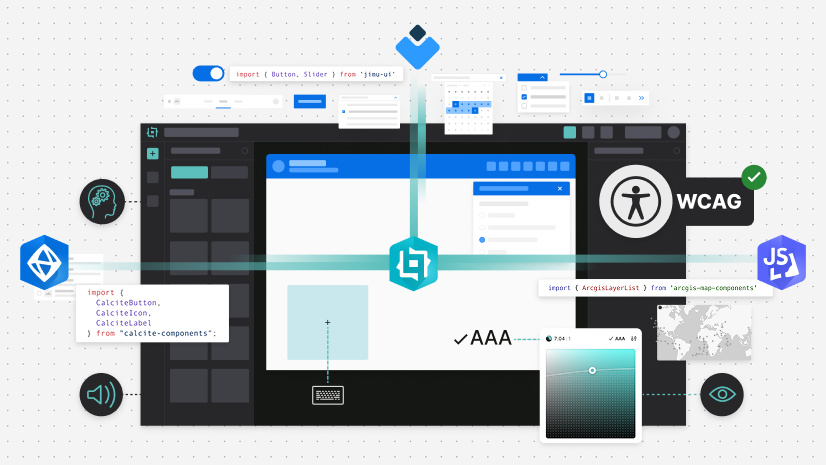
Building Accessible Custom Widgets in ArcGIS Experience Builder with Jimu UI, Calcite, and JavaScript Maps SDK Components
Create accessible ArcGIS Experience Builder widgets with Jimu UI, Calcite, and JavaScript Maps SDK …
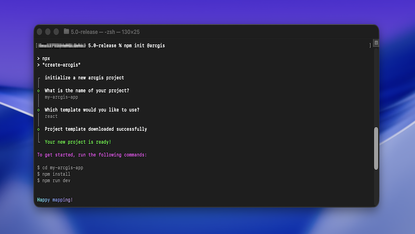
Quick Start New JavaScript Maps SDK Projects with @arcgis/create
Quickly scaffold web mapping apps in any framework with the @arcgis/create CLI, powered by the ArcGIS Maps SDK for …
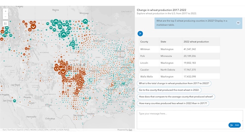
Introducing AI components (beta) in the ArcGIS Maps SDK for JavaScript
We're pleased to announce the beta release of the AI components package in the ArcGIS Maps SDK for JavaScript (JS Maps …
Concepts
Blogs are categorized by their concept topic. Navigate to any concept by clicking on the concept title in the sidebar or link below.
3D
| Date | Title | Release |
|---|---|---|
| October 17, 2024 | 4.30 | |
| August 7, 2024 | 4.30 | |
| July 23, 2024 | 4.30 | |
| March 8, 2024 | 4.29 | |
| November 10, 2022 | 4.25 | |
| October 20, 2022 | 4.24 | |
| October 5, 2022 | 4.24 | |
| August 1, 2022 | 4.24 | |
| July 8, 2021 | 4.20 | |
| April 29, 2021 | 4.19 | |
| February 18, 2021 | 4.18 | |
| August 20, 2020 | 4.16 | |
| April 22, 2020 | 4.15 | |
| April 22, 2020 | 4.15 | |
| April 10, 2020 | 4.15 | |
| January 26, 2020 | 4.14 | |
| December 23, 2019 | 4.14 | |
| December 13, 2019 | 4.14 | |
| November 26, 2019 | 4.13 | |
| August 26, 2019 | 4.12 | |
| April 25, 2019 | 4.11 | |
| March 1, 2019 | 4.11 | |
| October 15, 2018 | 4.9 | |
| September 27, 2018 | 4.9 | |
| July 20, 2018 | 4.8 | |
| July 12, 2018 | 4.8 | |
| June 5, 2018 | 4.7 | |
| May 26, 2018 | 4.7 | |
| May 21, 2018 | 4.7 | |
| April 24, 2018 | 4.7 | |
| February 13, 2018 | 4.6 | |
| September 5, 2017 | 4.5 | |
| August 15, 2017 | 4.4 | |
| July 14, 2017 | 4.4 | |
| April 12, 2017 | 4.3 | |
| February 1, 2016 | 4.0 | |
| January 25, 2016 | 4.0 | |
| January 19, 2016 | 4.0 |
Apps and solutions
| Date | Title | Release |
|---|---|---|
| December 20, 2024 | 4.31 | |
| December 19, 2024 | 4.31 | |
| April 29, 2024 | 4.29 | |
| January 20, 2021 | 4.18 | |
| August 13, 2020 | 4.16 | |
| May 5, 2020 | 4.15 | |
| March 3, 2017 | 4.3 |
Arcade
| Date | Title | Release |
|---|---|---|
| June 16, 2023 | 4.27 | |
| June 6, 2023 | 4.26 | |
| April 25, 2023 | 4.26 | |
| December 5, 2022 | 4.25 | |
| November 10, 2022 | 4.25 | |
| September 7, 2022 | 4.24 | |
| August 22, 2022 | 4.24 | |
| August 16, 2022 | 4.24 | |
| April 21, 2022 | 4.23 | |
| January 10, 2022 | 4.22 | |
| August 19, 2020 | 4.16 | |
| June 10, 2020 | 4.15 | |
| December 8, 2018 | 4.10 | |
| January 15, 2019 | 4.10 | |
| October 15, 2018 | 4.9 | |
| October 10, 2018 | 4.9 | |
| October 8, 2018 | 4.9 | |
| October 3, 2018 | 4.9 | |
| October 1, 2018 | 4.9 | |
| June 5, 2018 | 4.7 | |
| March 15, 2018 | 4.6 | |
| October 18, 2017 | 4.5 | |
| May 23, 2017 | 4.3 | |
| January 10, 2017 | 4.2 |
Developers
| Date | Title | Release |
|---|---|---|
| October 10, 2025 | 4.34 | |
| July 9, 2024 | 4.30 | |
| November 13, 2023 | 4.28 | |
| April 10, 2023 | 4.26 | |
| February 22, 2023 | 4.26 | |
| February 21, 2023 | 4.25 | |
| December 16, 2022 | 4.25 | |
| November 16, 2022 | 4.25 | |
| September 22, 2021 | 4.21 | |
| May 18, 2021 | 4.19 | |
| August 16, 2020 | 4.16 | |
| July 10, 2020 | 4.16 | |
| June 30, 2020 | 4.15 | |
| April 24, 2020 | 4.15 | |
| July 8, 2019 | 4.12 | |
| March 29, 2019 | 4.11 | |
| January 17, 2019 | 4.10 | |
| August 30, 2018 | 4.8 | |
| August 23, 2018 | 4.8 | |
| August 17, 2018 | 4.8 | |
| August 9, 2018 | 4.8 | |
| December 14, 2017 | 4.6 | |
| December 28, 2017 | 4.6 | |
| February 26, 2018 | 4.6 | |
| December 21, 2017 | 4.6 | |
| October 4, 2017 | 4.5 | |
| January 11, 2017 | 4.2 | |
| February 6, 2017 | 4.2 | |
| February 21, 2014 | 4.0 | |
| September 29, 2011 | 4.0 | |
| April 14, 2016 | 4.0 | |
| January 23, 2014 | 4.0 | |
| September 10, 2009 | 4.0 |
Developer tooling
| Date | Title | Release |
|---|---|---|
| July 5, 2022 | 4.24 | |
| June 21, 2022 | 4.23 | |
| April 14, 2022 | 4.23 | |
| April 26, 2021 | 4.19 | |
| April 22, 2021 | 4.19 | |
| January 15, 2021 | 4.18 | |
| November 3, 2020 | 4.17 | |
| March 26, 2020 | 4.14 | |
| February 25, 2019 | 4.10 | |
| December 4, 2018 | 4.10 | |
| October 16, 2018 | 4.9 | |
| June 21, 2018 | 4.7 | |
| April 27, 2018 | 4.7 | |
| December 14, 2017 | 4.6 | |
| September 8, 2017 | 4.5 |
Labeling
| Date | Title | Release |
|---|---|---|
| October 05, 2022 | 4.24 | |
| July 9, 2020 | 4.16 | |
| January 2, 2019 | 4.10 | |
| July 5, 2018 | 4.8 |
Layers and graphics
| Date | Title | Release |
|---|---|---|
| February 13, 2020 | 4.14 | |
| September 29, 2017 | 4.5 | |
| October 27, 2017 | 4.5 | |
| June 29, 2011 | 4.0 | |
| February 8, 2010 | 4.0 | |
| November 11, 2009 | 4.0 |
Popups
| Date | Title | Release |
|---|---|---|
| June 20, 2023 | 4.27 | |
| December 6, 2022 | 4.25 | |
| October 22, 2020 | 4.17 | |
| September 1, 2020 | 4.16 | |
| April 10, 2020 | 4.15 | |
| October 26, 2018 | 4.9 |
Symbols
| Date | Title | Release |
|---|---|---|
| August 7, 2023 | 4.27 | |
| November 17, 2022 | 4.25 | |
| September 22, 2021 | 4.21 | |
| July 24, 2020 | 4.16 | |
| March 28, 2017 | 4.3 | |
| October 26, 2009 | 4.0 | |
| June 22, 2016 | 4.0 | |
| February 3, 2012 | 4.0 |
Widgets
| Date | Title | Release |
|---|---|---|
| August 4, 2020 | 4.16 | |
| October 18, 2019 | 4.13 | |
| August 27, 2019 | 4.12 | |
| August 7, 2019 | 4.12 | |
| June 21, 2019 | 4.12 | |
| January 11, 2019 | 4.10 | |
| May 15, 2018 | 4.7 |
Visualization
| Date | Title | Release |
|---|---|---|
| November 4, 2024 | 4.31 | |
| April 10, 2024 | 4.29 | |
| January 3, 2023 | 4.25 | |
| December 13, 2022 | 4.25 | |
| November 29, 2022 | 4.25 | |
| July 6, 2022 | 4.24 | |
| March 31, 2022 | 4.23 | |
| March 3, 2022 | 4.22 | |
| December 9, 2021 | 4.22 | |
| October 11, 2021 | 4.21 | |
| August 31, 2021 | 4.20 | |
| August 31, 2021 | 4.20 | |
| May 12, 2021 | 4.19 | |
| May 3, 2021 | 4.19 | |
| April 22, 2021 | 4.19 | |
| February 3, 2021 | 4.18 | |
| January 5, 2021 | 4.18 | |
| October 5, 2020 | 4.17 | |
| September 8, 2020 | 4.16 | |
| April 27, 2020 | 4.15 | |
| January 29, 2020 | 4.14 | |
| January 14, 2020 | 4.14 | |
| January 7, 2020 | 4.14 | |
| April 25, 2019 | 4.11 | |
| April 16, 2019 | 4.11 | |
| April 9, 2019 | 4.11 | |
| April 1, 2019 | 4.11 | |
| December 20, 2018 | 4.10 | |
| January 14, 2019 | 4.10 | |
| September 4, 2018 | 4.9 | |
| August 6, 2018 | 4.8 | |
| October 11, 2017 | 4.5 | |
| April 13, 2017 | 4.3 | |
| May 25, 2016 | 4.0 | |
| March 28, 2016 | 4.0 | |
| January 11, 2016 | 4.0 |
Release blog
| Date | Title | Release |
|---|---|---|
| October 21, 2025 | 4.34 | |
| June 24, 2025 | 4.33 | |
| February 24, 2025 | 4.32 | |
| November 22, 2024 | 4.31 | |
| November 7, 2024 | 4.31 | |
| July 2, 2024 | 4.30 | |
| June 27, 2024 | 4.30 | |
| February 26, 2024 | 4.29 | |
| October 23, 2023 | 4.28 | |
| October 23, 2023 | 4.28 | |
| June 28, 2023 | 4.27 | |
| June 12, 2023 | 4.27 | |
| April 3, 2023 | 4.26 | |
| February 27, 2023 | 4.26 | |
| February 22, 2023 | 4.26 | |
| November 17, 2022 | 4.25 | |
| November 9, 2022 | 4.25 | |
| June 23, 2022 | 4.24 | |
| June 22, 2022 | 4.23 | |
| April 7, 2022 | 4.23 | |
| March 23, 2022 | 4.23 |
Conferences
| Date | Title | Release |
|---|---|---|
| June 23, 2025 | 4.33 | |
| March 6, 2025 | 4.32 | |
| August 20, 2024 | 4.30 | |
| March 4, 2024 | 4.29 | |
| February 24, 2023 | 4.26 | |
| July 11, 2021 | 4.20 | |
| April 4, 2021 | 4.18 | |
| July 2, 2020 | 4.16 | |
| June 23, 2020 | 4.15 | |
| April 24, 2020 | 4.15 |
Authors
View all blog posts from an individual author by selecting their name.