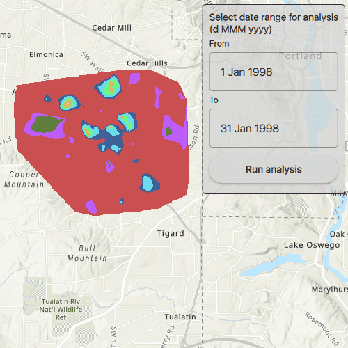
This sample demonstrates how to execute a geoprocessing task to calculate a hotspot analysis based on the frequency of 911 calls. It calculates the frequency of these calls within a given study area during a specified constrained time period set between 1/1/1998 and 5/31/1998.
Use case
This tool identifies statistically significant spatial clusters of high values (hot spots) and low values (cold spots). For example, a hotspot analysis based on the frequency of 911 calls within a set region.
How to use the sample
Select a date range (between 1998-01-01 and 1998-05-31) from the dialog and tap on Analyze. The results will be shown on the map upon successful completion of the GeoprocessingJob.
How it works
- Create a
GeoprocessingTaskwith the URL set to the endpoint of a geoprocessing service. - Create a query string with the date range as an input of
GeoprocessingParameters. - Use the
GeoprocessingTaskto create aGeoprocessingJobwith theGeoprocessingParametersinstance. - Start the
GeoprocessingJoband wait for it to complete and return aGeoprocessingResult. - Get the resulting
ArcGISMapImageLayerusingGeoprocessingResult.MapImageLayer. - Add the layer to the map's operational layers.
Relevant API
- ArcGISMapImageLayer
- GeoprocessingJob
- GeoprocessingParameters
- GeoprocessingResult
- GeoprocessingString
- GeoprocessingTask
- Map
Tags
analysis, density, geoprocessing, hot spots, hotspots
Sample Code
AnalyzeHotspots.qml
// [WriteFile Name=AnalyzeHotspots, Category=Analysis]
// [Legal]
// Copyright 2017 Esri.
// Licensed under the Apache License, Version 2.0 (the "License");
// you may not use this file except in compliance with the License.
// You may obtain a copy of the License at
// http://www.apache.org/licenses/LICENSE-2.0
// Unless required by applicable law or agreed to in writing, software
// distributed under the License is distributed on an "AS IS" BASIS,
// WITHOUT WARRANTIES OR CONDITIONS OF ANY KIND, either express or implied.
// See the License for the specific language governing permissions and
// limitations under the License.
// [Legal]
import QtQuick
import QtQuick.Controls
// import Qt.labs.calendar // Calendar is not supported in Qt 6.2
import Esri.ArcGISRuntime
import QtQuick.Layouts
Rectangle {
id: rootRectangle
clip: true
width: 800
height: 600
property var job
property bool jobInProgress : false
property string statusText: ""
property date fromThisDate : Date.fromLocaleDateString(Qt.locale(), "98/01/01", "yy/MM/dd");
property date toThisDate : Date.fromLocaleDateString(Qt.locale(), "98/01/31", "yy/MM/dd")
// Declare the MapView with a Map and Basemap
MapView {
id: mapView
anchors.fill: parent
Component.onCompleted: {
// Set the focus on MapView to initially enable keyboard navigation
forceActiveFocus();
}
Map {
Basemap {
initStyle: Enums.BasemapStyleArcGISTopographic
}
}
}
// Declare the GeoprocessingTask and set the URL
GeoprocessingTask {
id: hotspotTask
url: "https://sampleserver6.arcgisonline.com/arcgis/rest/services/911CallsHotspot/GPServer/911%20Calls%20Hotspot"
onErrorChanged: {
if (error)
showErrorDialog(error);
}
function runTask() {
// Create job that handles the communication between the application and the geoprocessing task
job = hotspotTask.createJob(hotspotParameters);
// Connect to the job's status changed signal
job.statusChanged.connect(()=> {
if (job.jobStatus === Enums.JobStatusFailed) {
showErrorDialog(job.error);
jobInProgress = false;
statusText = "Job failed.";
} else if (job.jobStatus === Enums.JobStatusStarted) {
jobInProgress = true;
statusText = "Job in progress...";
} else if (job.jobStatus === Enums.JobStatusPaused) {
jobInProgress = false;
statusText = "Job paused...";
} else if (job.jobStatus === Enums.JobStatusSucceeded) {
// handle the results
processResults(job.result);
jobInProgress = false;
statusText = "Job succeeded.";
}
});
// Execute analysis and wait for the results
job.start();
}
// Extract the layer from the result and add to the map
function processResults(result) {
mapView.map.operationalLayers.clear();
const layer = result.mapImageLayer;
layer.loadStatusChanged.connect(()=> {
if (layer.loadStatus === Enums.LoadStatusLoaded)
mapView.setViewpointGeometry(layer.fullExtent);
});
mapView.map.operationalLayers.append(layer);
}
function showErrorDialog(error) {
messageDialog.title = "Error";
messageDialog.text = "Executing geoprocessing failed.";
messageDialog.detailedText = error ? error.additionalMessage : "Unknown error";
messageDialog.open();
}
}
// Declare the GeoprocessingParameters and set the execution type
GeoprocessingParameters {
id: hotspotParameters
executionType: Enums.GeoprocessingExecutionTypeAsynchronousSubmit
function addParameter(fromDateString, toDateString) {
// create the query string
let queryString = "(\"DATE\" > date '%1 00:00:00' AND \"DATE\" < date '%2 00:00:00')"
queryString = queryString.arg(fromDateString).arg(toDateString);
// Add query that contains the date range and the days of the week that are used in analysis
const inputs = {};
inputs["Query"] = ArcGISRuntimeEnvironment.createObject("GeoprocessingString", { value: queryString });
hotspotParameters.inputs = inputs;
// run the task
hotspotTask.runTask();
}
}
// Create the settings rectangle to set dates and execute the task
Rectangle {
anchors {
margins: -10
fill: settingsColumn
}
color: "lightgrey"
radius: 5
border.color: "black"
opacity: 0.75
}
Column {
id: settingsColumn
anchors {
right: parent.right
top: parent.top
margins: 20
}
spacing: 5
Text {
anchors.horizontalCenter: parent.horizontalCenter
text: "Select date range for analysis\n(d MMM yyyy)"
font.pixelSize: 14
}
Text {
text: "From"
font.pixelSize: 12
}
TextField {
id: fromDate
width: parent.width
text: "1 Jan 1998"
onTextChanged: {
fromThisDate = Date.fromLocaleString(Qt.locale(), text, "d MMM yyyy")
validateDates();
}
selectByMouse: true
}
Text {
text: "To"
font.pixelSize: 12
}
TextField {
id: toDate
width: parent.width
text: "31 Jan 1998"
onTextChanged: {
toThisDate = Date.fromLocaleString(Qt.locale(), text, "d MMM yyyy")
validateDates();
}
selectByMouse: true
}
Button {
width: parent.width
anchors.horizontalCenter: parent.horizontalCenter
text: "Run analysis"
enabled: !jobInProgress && validateDates(fromThisDate, toThisDate)
onClicked: {
const fromString = fromThisDate.toLocaleString(Qt.locale(), "yyyy-MM-dd");
const toString = toThisDate.toLocaleString(Qt.locale(), "yyyy-MM-dd");
// Run the task
hotspotParameters.addParameter(fromString, toString);
}
}
Row {
spacing: 15
visible: jobInProgress
BusyIndicator {
anchors.verticalCenter: parent.verticalCenter
width: 24
height: width
}
Text {
anchors.verticalCenter: parent.verticalCenter
text: statusText
font.pixelSize: 14
}
}
}
Dialog {
id: messageDialog
modal: true
x: Math.round(parent.width - width) / 2
y: Math.round(parent.height - height) / 2
standardButtons: Dialog.Ok
title: "Error"
property alias text : textLabel.text
property alias detailedText : detailsLabel.text
ColumnLayout {
Text {
id: textLabel
}
Text {
id: detailsLabel
}
}
}
// function to validate the date ranges provided
function validateDates() {
// check that the to date is after the from date
if (fromThisDate > toThisDate) {
return false;
}
// check that there is at least one day in between the from and to date
const oneDay = 86400000;
if ((toThisDate - fromThisDate) < oneDay) {
return false;
}
return true;
}
}