Use the Geometry Editor to create new point, multipoint, polyline, or polygon geometries or to edit existing geometries by interacting with a map view.
Use case
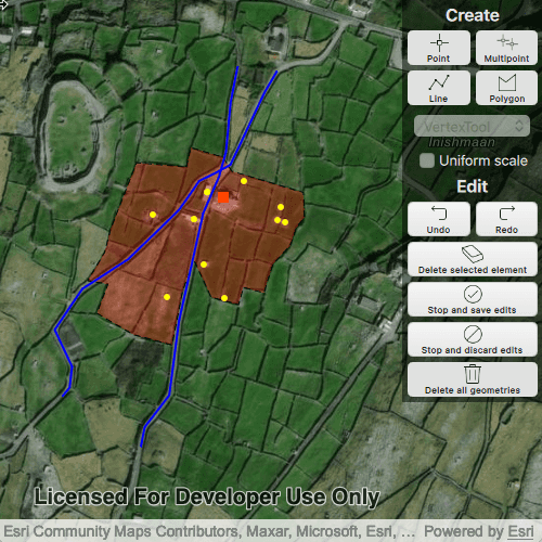
A field worker can mark features of interest on a map using an appropriate geometry. Features such as sample or observation locations, fences or pipelines, and building footprints can be digitized using point, multipoint, polyline, and polygon geometry types. Polyline and polygon geometries can be created and edited using a vertex-based creation and editing tool (i.e. vertex locations specified explicitly via tapping), or using a freehand tool.
How to use the sample
To create a new geometry, press the button appropriate for the geometry type you want to create (i.e. points, multipoints, polyline, or polygon) and interactively tap and drag on the map view to create the geometry.
To edit an existing geometry, tap the geometry to be edited in the map to select it and then edit the geometry by tapping and dragging elements of the geometry.
When the whole geometry is selected, you can use the control handles to scale and rotate the geometry.
If creating or editing polyline or polygon geometries, choose the desired creation/editing tool from the combo box.
Use the control panel to undo or redo changes made to the geometry, delete a selected element, save the geometry, stop the editing session and discard any edits, and remove all geometries from the map.
How it works
-
Create a
GeometryEditorand set it to the MapView usingmapView.setGeometryEditor(GeometryEditor). -
Start the
GeometryEditorusingGeometryEditor.start(GeometryType)to create a new geometry orGeometryEditor.start(Geometry)to edit an existing geometry.- If using the Geometry Editor to edit an existing geometry, the geometry must be retrieved from the graphics overlay being used to visualize the geometry prior to calling the start method. To do this:
- Use
MapView.identifyGraphicsOverlay(...)to identify graphics at the location of a tap. - Access the
MapView.identifyGraphicsOverlay(...)results usingMapView.identifyGraphicsOverlayResult. - Find the desired graphic in the
IdentifyGraphicsOverlayResult.graphicslist. - Access the geometry associated with the
GraphicusingGraphic.geometry()- this will be used in theGeometryEditor.start(Geometry)method.
- Use
- If using the Geometry Editor to edit an existing geometry, the geometry must be retrieved from the graphics overlay being used to visualize the geometry prior to calling the start method. To do this:
-
Create
VertexTool,FreehandTool, orShapeToolobjects which define how the user interacts with the view to create or edit geometries, usinggeometryEditor.setTool(geometryEditorTool). -
Edit a tool's
InteractionConfigurationto set theGeometryEditorScaleModeto allow either uniform or stretch scale mode. -
Check to see if undo and redo are possible during an editing session using
GeometryEditor.canUndo()andGeometryEditor.canRedo(). If it's possible, useGeometryEditor.undo()andGeometryEditor.redo(). -
Check whether the currently selected
GeometryEditorElementcan be deleted (GeometryEditor.selectedElement.canDelete). If the element can be deleted, delete usingGeometryEditor.deleteSelectedElement. -
Call
GeometryEditor.stop()to finish the editing session. TheGeometryEditordoes not automatically handle the visualization of a geometry output from an editing session. This must be done manually by propagating the geometry returned byGeometryEditor.stop()into aGraphicand aGraphicsOverlay.- To create a new
Graphicin theGraphicsOverlay:- Using
Graphic.Graphic(Geometry), create a new Graphic with the geometry returned by theGeometryEditor.stop()method. - Append the
Graphicto theGraphicsOverlay'sGraphicListModel(i.e.GraphicsOverlay.graphics.append(Graphic)).
- Using
- To update the geometry underlying an existing
Graphicin theGraphicsOverlay:- Replace the existing
Graphic'sGeometryproperty with the geometry returned by theGeometryEditor.stop()method usingGraphic.setGeometry(Geometry).
- Replace the existing
- To create a new
Relevant API
- Geometry
- GeometryEditor
- Graphic
- GraphicsOverlay
- MapView
Additional information
The sample opens with the ArcGIS Imagery basemap centered on the island of Inis Meáin (Aran Islands) in Ireland. Inis Meáin comprises a landscape of interlinked stone walls, roads, buildings, archaeological sites, and geological features, producing complex geometrical relationships.
Tags
draw, edit, freehand, geometry editor, sketch, vertex
Sample Code
// [WriteFile Name=CreateAndEditGeometries, Category=Geometry]
// [Legal]
// Copyright 2023 Esri.
// Licensed under the Apache License, Version 2.0 (the "License");
// you may not use this file except in compliance with the License.
// You may obtain a copy of the License at
// http://www.apache.org/licenses/LICENSE-2.0
// Unless required by applicable law or agreed to in writing, software
// distributed under the License is distributed on an "AS IS" BASIS,
// WITHOUT WARRANTIES OR CONDITIONS OF ANY KIND, either express or implied.
// See the License for the specific language governing permissions and
// limitations under the License.
// [Legal]
import QtQuick
import QtQuick.Controls
import QtQuick.Layouts
import Esri.ArcGISRuntime
Rectangle {
id: rootRectangle
clip: true
width: 800
height: 600
// When editing an existing geometry, a reference to the Graphic being used to visualise the
// geometry is needed in order to update the graphic with any changes made during editing.
property Graphic selectedGraphic: null
MapView {
id: mapView
anchors.fill: parent
Map {
Basemap {
initStyle: Enums.BasemapStyleArcGISImagery
}
ViewpointCenter {
center: Point {
x: -9.5920
y: 53.08230
spatialReference: SpatialReference { wkid: 4326 }
}
targetScale: 5000
}
}
geometryEditor: geometryEditor
GraphicsOverlay {
id: geometriesOverlay
}
Component.onCompleted: {
// Set and keep the focus on MapView to enable keyboard navigation
forceActiveFocus();
createInitialGraphics();
}
onMouseClicked: mouse => {
if (geometryEditor.started)
return;
const tolerance = 5;
const returnPopupsOnly = false;
mapView.identifyGraphicsOverlay(geometriesOverlay, mouse.x, mouse.y, tolerance, returnPopupsOnly);
}
onIdentifyGraphicsOverlayStatusChanged: {
if (identifyGraphicsOverlayStatus !== Enums.TaskStatusCompleted)
return;
if (mapView.identifyGraphicsOverlayResult.graphics.length === 0)
return; // No graphic at location of tap.
else if (mapView.identifyGraphicsOverlayResult.graphics.length > 1) {
console.log(qsTr("Multiple graphics identified - cannot identify the intended graphic."));
return;
}
selectedGraphic = identifyGraphicsOverlayResult.graphics[0];
// If a point or multipoint has been selected, we need to use a vertex tool - the UI also needs updating.
if (selectedGraphic.geometry.geometryType === Enums.GeometryTypePoint || selectedGraphic.geometry.geometryType === Enums.GeometryTypeMultipoint) {
geometryEditor.tool = vertexTool;
toolCombo.currentIndex = 0;
}
geometryEditor.startWithGeometry(selectedGraphic.geometry);
selectedGraphic.visible = false; // Reduce clutter in the view by hiding graphic during editing session.
}
}
GeometryEditor {
id: geometryEditor
onStartedChanged: {
// If an editing session has been started by selecting a graphic (i.e. the button for the geometry type was not
// pressed) the checked property should be set on the appropriate button. This will highlight the button.
if (started) {
switch (geometry.geometryType) {
case Enums.GeometryTypePoint:
pointButton.checked = true;
break;
case Enums.GeometryTypeMultipoint:
multiPointButton.checked = true;
break;
case Enums.GeometryTypePolyline:
lineButton.checked = true;
break;
case Enums.GeometryTypePolygon:
polygonButton.checked = true;
break;
}
}
// Once the editing session has stopped, return all buttons to unchecked state.
else {
pointButton.checked = false;
multiPointButton.checked = false;
lineButton.checked = false;
polygonButton.checked = false;
}
}
}
VertexTool {
id: vertexTool
}
FreehandTool {
id: freehandTool
}
property ShapeTool arrowTool: Factory.ShapeTool.create(Enums.ShapeToolTypeArrow);
property ShapeTool ellipseTool: Factory.ShapeTool.create(Enums.ShapeToolTypeEllipse);
property ShapeTool rectangleTool: Factory.ShapeTool.create(Enums.ShapeToolTypeRectangle);
property ShapeTool triangleTool: Factory.ShapeTool.create(Enums.ShapeToolTypeTriangle);
SimpleMarkerSymbol {
id: pointSymbol
style: Enums.SimpleMarkerSymbolStyleSquare
color: "orangered"
size: 10
}
SimpleMarkerSymbol {
id: multiPointSymbol
style: Enums.SimpleMarkerSymbolStyleCircle
color: "yellow"
size: 5
}
SimpleLineSymbol {
id: polylineSymbol
style: Enums.SimpleLineSymbolStyleSolid
color: "blue"
width: 2
}
SimpleFillSymbol {
id: polygonSymbol
style: Enums.SimpleFillSymbolStyleSolid
color: Qt.rgba(1, 0, 0, 0.3)
outline: SimpleLineSymbol {
style: Enums.SimpleLineSymbolStyleDash
width: 1
color: "black"
}
}
// Prevent mouse interaction from propagating to the MapView
MouseArea {
anchors.fill: control
onPressed: mouse => mouse.accepted = true;
onWheel: wheel => wheel.accepted = true;
}
Control {
id: control
anchors.right: parent.right
padding: 5
width: 130
background: Rectangle {
color: "black"
opacity: .5
}
contentItem: ColumnLayout {
id: columns
anchors {
verticalCenter: parent.verticalCenter
horizontalCenter: parent.horizontalCenter
}
GridLayout {
id: geometryColumn
Layout.alignment: Qt.AlignHCenter | Qt.AlignVCenter
columns: 2
Text {
id: geometryHeader
Layout.alignment: Qt.AlignHCenter | Qt.AlignVCenter
Layout.columnSpan: 2
text: "Create"
color: "white"
font.pixelSize: 16
font.bold: true
}
GeometryEditorButton {
id: pointButton
buttonName: qsTr("Point")
iconPath: "qrc:/Samples/Geometry/CreateAndEditGeometries/iconAssets/point-32.png"
checkable: true
enabled: !geometryEditor.started
onClicked: {
geometryEditor.tool = vertexTool;
toolCombo.currentIndex = 0;
geometryEditor.startWithGeometryType(Enums.GeometryTypePoint);
}
}
GeometryEditorButton {
id: multiPointButton
buttonName: qsTr("Multipoint")
iconPath: "qrc:/Samples/Geometry/CreateAndEditGeometries/iconAssets/multipoint-32.png"
checkable: true
enabled: !geometryEditor.started
onClicked: {
geometryEditor.tool = vertexTool;
toolCombo.currentIndex = 0;
geometryEditor.startWithGeometryType(Enums.GeometryTypeMultipoint);
}
}
GeometryEditorButton {
id: lineButton
buttonName: qsTr("Line")
iconPath: "qrc:/Samples/Geometry/CreateAndEditGeometries/iconAssets/line-32.png"
checkable: true
enabled: !geometryEditor.started
onClicked: geometryEditor.startWithGeometryType(Enums.GeometryTypePolyline);
}
GeometryEditorButton {
id: polygonButton
buttonName: qsTr("Polygon")
iconPath: "qrc:/Samples/Geometry/CreateAndEditGeometries/iconAssets/polygon-32.png"
checkable: true
enabled: !geometryEditor.started
onClicked: geometryEditor.startWithGeometryType(Enums.GeometryTypePolygon);
}
ComboBox {
id: toolCombo
model: [qsTr("VertexTool"), qsTr("FreehandTool"), qsTr("Arrow ShapeTool"), qsTr("Ellipse ShapeTool"), qsTr("Rectangle ShapeTool"), qsTr("Triangle ShapeTool")]
Layout.columnSpan: 2
Layout.fillWidth: true
Rectangle {
anchors.fill: parent
radius: 10
// Make the rectangle visible if a dropdown indicator exists
// An indicator only exists if a theme is set
visible: parent.indicator
border.width: 1
}
enabled: {
if (!geometryEditor.started)
false;
else {
switch (geometryEditor.geometry.geometryType) {
case Enums.GeometryTypePoint:
case Enums.GeometryTypeMultipoint:
false;
break;
case Enums.GeometryTypePolyline:
case Enums.GeometryTypePolygon:
true;
}
}
}
onActivated: {
switch (currentIndex) {
case 0: // Vertex Tool
geometryEditor.tool = vertexTool;
break;
case 1: // Freehand Tool
geometryEditor.tool = freehandTool;
break;
case 2: // ShapeTool with arrow shape type
geometryEditor.tool = arrowTool;
break;
case 3: // ShapeTool with ellipse shape type
geometryEditor.tool = ellipseTool;
break;
case 4: // ShapeTool with rectangle shape type
geometryEditor.tool = rectangleTool;
break;
case 5: // ShapeTool with triangle shape type
geometryEditor.tool = triangleTool;
break;
default:
geometryEditor.tool = vertexTool;
}
}
}
}
CheckBox {
id: uniformScaleCheckBox
Layout.alignment: Qt.AlignHCenter | Qt.AlignVCenter
Layout.columnSpan: 2
text: "<font color=\"white\">Uniform scale</font>"
enabled: {
if (!geometryEditor.started) {
false;
}
else {
switch (geometryEditor.geometry.geometryType) {
case Enums.GeometryTypePoint:
false;
break;
case Enums.GeometryTypeMultipoint:
case Enums.GeometryTypePolyline:
case Enums.GeometryTypePolygon:
true;
}
}
}
checked: geometryEditor.tool.configuration.scaleMode === Enums.GeometryEditorScaleModeUniform;
onCheckStateChanged:
{
vertexTool.configuration.scaleMode = (checked ? Enums.GeometryEditorScaleModeUniform : Enums.GeometryEditorScaleModeStretch)
freehandTool.configuration.scaleMode = (checked ? Enums.GeometryEditorScaleModeUniform : Enums.GeometryEditorScaleModeStretch)
arrowTool.configuration.scaleMode = (checked ? Enums.GeometryEditorScaleModeUniform : Enums.GeometryEditorScaleModeStretch)
ellipseTool.configuration.scaleMode = (checked ? Enums.GeometryEditorScaleModeUniform : Enums.GeometryEditorScaleModeStretch)
rectangleTool.configuration.scaleMode = (checked ? Enums.GeometryEditorScaleModeUniform : Enums.GeometryEditorScaleModeStretch)
triangleTool.configuration.scaleMode = (checked ? Enums.GeometryEditorScaleModeUniform : Enums.GeometryEditorScaleModeStretch)
}
}
GridLayout {
id: editingColumn
Layout.fillWidth: true
Layout.alignment: Qt.AlignHCenter | Qt.AlignVCenter
columns: 2
Text {
id: editingHeader
Layout.alignment: Qt.AlignHCenter | Qt.AlignVCenter
Layout.columnSpan: 2
text: qsTr("Edit")
color: "white"
font.pixelSize: 16
font.bold: true
}
GeometryEditorButton {
id: undoButton
buttonName: qsTr("Undo")
iconPath: "qrc:/Samples/Geometry/CreateAndEditGeometries/iconAssets/undo-32.png"
enabled: geometryEditor.started && geometryEditor.canUndo
onClicked: geometryEditor.undo();
}
GeometryEditorButton {
id: redoButton
buttonName: qsTr("Redo")
iconPath: "qrc:/Samples/Geometry/CreateAndEditGeometries/iconAssets/redo-32.png"
enabled: geometryEditor.started && geometryEditor.canRedo
onClicked: geometryEditor.redo();
}
GeometryEditorButton {
id: deleteVertexButton
buttonName: qsTr("Delete selected element")
iconPath: "qrc:/Samples/Geometry/CreateAndEditGeometries/iconAssets/erase-32.png"
Layout.columnSpan: 2
enabled: geometryEditor.started && geometryEditor.selectedElement && geometryEditor.selectedElement.canDelete
onClicked: geometryEditor.deleteSelectedElement();
}
GeometryEditorButton {
id: saveEditsButton
buttonName: qsTr("Stop and save edits")
iconPath: "qrc:/Samples/Geometry/CreateAndEditGeometries/iconAssets/check-circle-32.png"
Layout.columnSpan: 2
enabled: geometryEditor.started && geometryEditor.canUndo
onClicked: {
if (geometryEditor.geometry.empty) {
console.log(qsTr("Unable to save geometry. Geometry is empty."));
return;
}
if (selectedGraphic)
updateSelectedGraphic();
else
createNewGraphicAndAppendToGraphicsOverlay();
}
}
GeometryEditorButton {
id: discardEditsButton
buttonName: qsTr("Stop and discard edits")
iconPath: "qrc:/Samples/Geometry/CreateAndEditGeometries/iconAssets/circle-disallowed-32.png"
Layout.columnSpan: 2
enabled: geometryEditor.started
onClicked: {
if (selectedGraphic) {
geometryEditor.stop();
selectedGraphic.visible = true;
selectedGraphic = null;
}
else
geometryEditor.stop();
}
}
GeometryEditorButton {
id: clearGraphicsButton
buttonName: qsTr("Delete all geometries")
iconPath: "qrc:/Samples/Geometry/CreateAndEditGeometries/iconAssets/trash-32.png"
Layout.columnSpan: 2
enabled: !geometryEditor.started && geometriesOverlay.graphics.count > 0;
onClicked: geometriesOverlay.graphics.clear();
}
}
}
}
Point {
id: house
json: {"x":-1067898.59,
"y":6998366.62,
"spatialReference":{"latestWkid":3857,"wkid":102100}
}
}
Multipoint {
id: outbuildings
json: { "points":[[-1067984.26,6998346.28],[-1067966.80,6998244.84],
[-1067921.88,6998284.65],[-1067934.36,6998340.74],
[-1067917.93,6998373.97],[-1067828.30,6998355.28],
[-1067832.25,6998339.70],[-1067823.10,6998336.93],
[-1067873.22,6998386.78],[-1067896.72,6998244.49]],
"spatialReference":{"latestWkid":3857,"wkid":102100}
}
}
Polyline {
id: road1
json: {"paths":[[[-1068095.40,6998123.52],[-1068086.16,6998134.60],
[-1068083.20,6998160.44],[-1068104.27,6998205.37],
[-1068070.63,6998255.22],[-1068014.44,6998291.54],
[-1067952.33,6998351.85],[-1067927.93,6998386.93],
[-1067907.97,6998396.78],[-1067889.86,6998406.63],
[-1067848.08,6998495.26],[-1067832.92,6998521.11]]],
"spatialReference":{"latestWkid":3857,"wkid":102100}}
}
Polyline {
id: road2
json: {"paths":[[[-1067999.28,6998061.97],[-1067994.48,6998086.59],
[-1067964.53,6998125.37],[-1067952.70,6998215.84],
[-1067923.13,6998347.54],[-1067903.90,6998391.86],
[-1067895.40,6998422.02],[-1067891.70,6998460.18],
[-1067889.49,6998483.56],[-1067880.98,6998527.26]]],
"spatialReference":{"latestWkid":3857,"wkid":102100}}
}
Polygon {
id: boundary
json: {"rings":[[[-1067943.67,6998403.86],[-1067938.17,6998427.60],
[-1067898.77,6998415.86],[-1067888.26,6998398.80],
[-1067800.85,6998372.93],[-1067799.61,6998342.81],
[-1067809.38,6998330.00],[-1067817.07,6998307.85],
[-1067838.07,6998285.34],[-1067849.10,6998250.38],
[-1067874.02,6998256.00],[-1067879.87,6998235.95],
[-1067913.41,6998245.03],[-1067934.84,6998291.34],
[-1067948.41,6998251.90],[-1067961.18,6998186.68],
[-1068008.59,6998199.49],[-1068052.89,6998225.45],
[-1068039.37,6998261.11],[-1068064.12,6998265.26],
[-1068043.32,6998299.88],[-1068036.25,6998327.93],
[-1068004.43,6998409.28],[-1067943.67,6998403.86]]],
"spatialReference":{"latestWkid":3857,"wkid":102100}}
}
function createInitialGraphics() {
const boundaryGraphic = ArcGISRuntimeEnvironment.createObject("Graphic", {geometry: boundary, symbol: polygonSymbol});
geometriesOverlay.graphics.append(boundaryGraphic);
const road1Graphic = ArcGISRuntimeEnvironment.createObject("Graphic", {geometry: road1, symbol: polylineSymbol});
geometriesOverlay.graphics.append(road1Graphic);
const road2Graphic = ArcGISRuntimeEnvironment.createObject("Graphic", {geometry: road2, symbol: polylineSymbol});
geometriesOverlay.graphics.append(road2Graphic);
const outbuildingsGraphic = ArcGISRuntimeEnvironment.createObject("Graphic", {geometry: outbuildings, symbol: multiPointSymbol});
geometriesOverlay.graphics.append(outbuildingsGraphic);
const houseGraphic = ArcGISRuntimeEnvironment.createObject("Graphic", {geometry: house, symbol: pointSymbol});
geometriesOverlay.graphics.append(houseGraphic);
}
function updateSelectedGraphic() {
selectedGraphic.geometry = geometryEditor.stop();
selectedGraphic.visible = true;
selectedGraphic = null;
}
function createNewGraphicAndAppendToGraphicsOverlay() {
// To save the geometry, create a graphic using the output from the geometry editor.
const graphic = ArcGISRuntimeEnvironment.createObject("Graphic");
switch (geometryEditor.geometry.geometryType) {
case Enums.GeometryTypePoint:
graphic.symbol = pointSymbol
break;
case Enums.GeometryTypeMultipoint:
graphic.symbol = multiPointSymbol
break;
case Enums.GeometryTypePolyline:
graphic.symbol = polylineSymbol
break;
case Enums.GeometryTypePolygon:
graphic.symbol = polygonSymbol
break;
default:
break;
}
graphic.geometry = geometryEditor.stop();
geometriesOverlay.graphics.append(graphic);
}
}