Control the behavior of the camera in a scene.
Use Case
The globe camera controller (the default camera controller in all new scenes) allows a user to explore the scene freely by zooming in/out and panning around the globe. The orbit camera controllers fix the camera to look at a target location or geoelement. A primary use case is for following moving objects like cars and planes.
How to use the sample
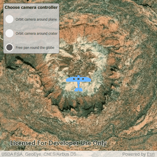
The application loads with the default globe camera controller. To rotate and fix the scene around the plane, exit globe mode by choosing the "Orbit camera around plane" option (i.e. camera will now be fixed to the plane). Choose the "Orbit camera around crater" option to rotate and center the scene around the location of the Upheaval Dome crater structure, or choose the "Free pan round the globe" option to return to default free navigation.
How it works
- Create an instance of a class extending
CameraController:GlobeCameraController,OrbitLocationCameraController,OrbitGeoElementCameraController. - Set the scene view's camera controller with
sceneView.cameraController.
Relevant API
- Scene
- Camera
- GlobeCameraController
- OrbitGeoElementCameraController
- OrbitLocationCameraController
- SceneView
Tags
camera controller, Camera, SceneView, 3D
Sample Code
// [WriteFile Name=ChooseCameraController, Category=Scenes]
// [Legal]
// Copyright 2019 Esri.
// Licensed under the Apache License, Version 2.0 (the "License");
// you may not use this file except in compliance with the License.
// You may obtain a copy of the License at
// http://www.apache.org/licenses/LICENSE-2.0
// Unless required by applicable law or agreed to in writing, software
// distributed under the License is distributed on an "AS IS" BASIS,
// WITHOUT WARRANTIES OR CONDITIONS OF ANY KIND, either express or implied.
// See the License for the specific language governing permissions and
// limitations under the License.
// [Legal]
import QtQuick
import Esri.ArcGISRuntime
import Esri.ArcGISExtras
import QtQuick.Controls
import QtQuick.Layouts
Rectangle {
clip: true
width: 800
height: 600
readonly property url dataPath: {
Qt.platform.os === "ios" ?
System.writableLocationUrl(System.StandardPathsDocumentsLocation) + "/ArcGIS/Runtime/Data/3D" :
System.writableLocationUrl(System.StandardPathsHomeLocation) + "/ArcGIS/Runtime/Data/3D"
}
readonly property real longitude: -109.929589
readonly property real latitude: 38.43500
readonly property real distance: 5000
GlobeCameraController {
id: globeController
}
Point {
id: theCrater
x: longitude
y: latitude
z: distance
spatialReference: SpatialReference { wkid: 4326 }
}
OrbitLocationCameraController {
id: orbitLocationCtrlr
targetLocation: theCrater
cameraDistance: distance
}
OrbitGeoElementCameraController{
id: orbitPlaneCtrlr
targetGeoElement: thePlane
cameraDistance: distance / 2
}
SceneView {
id: sceneView
anchors.fill: parent
Scene {
id: scene
Basemap {
initStyle: Enums.BasemapStyleArcGISImageryStandard
}
Surface {
ArcGISTiledElevationSource {
url: "https://elevation3d.arcgis.com/arcgis/rest/services/WorldElevation3D/Terrain3D/ImageServer"
}
}
}
GraphicsOverlay {
id: graphicsOverlay
LayerSceneProperties {
surfacePlacement: Enums.SurfacePlacementRelative
}
ModelSceneSymbol {
id: mms
url: dataPath + "/Bristol/Collada/Bristol.dae"
scale: 10.0
heading: 0.0
}
Graphic {
id: thePlane
symbol: mms
geometry: Point {
x: longitude
y: latitude
z: distance / 2
spatialReference: sceneView.spatialReference
}
}
}
Component.onCompleted: {
// Set the focus on SceneView to initially enable keyboard navigation
forceActiveFocus();
// set viewpoint to the specified camera
sceneView.setViewpointCamera(camera);
}
}
Camera {
id: camera
heading: 0.0
pitch: 0.0
roll: 0.0
location: theCrater
}
// Create a rectangle to display the GUI
Rectangle {
width: childrenRect.width
height: childrenRect.height
color: "lightgrey"
opacity: 0.8
radius: 5
anchors {
margins: 10
left: parent.left
top: parent.top
}
border {
color: "#4D4D4D"
width: 1
}
ColumnLayout {
Text {
Layout.margins: 5
Layout.fillWidth: true
text: "Choose camera controller"
clip: true
font {
pointSize: 14
bold: true
}
}
RadioButton {
id: orbitAroundAeroplane
Layout.fillWidth: true
text: "Orbit camera around plane"
onCheckedChanged: {
if (checked) {
sceneView.cameraController = orbitPlaneCtrlr;
}
}
}
RadioButton {
id: orbitLocation
Layout.fillWidth: true
text: "Orbit camera around crater"
onCheckedChanged: {
if (checked) {
sceneView.cameraController = orbitLocationCtrlr;
}
}
}
RadioButton {
id: orbitAroundGlobe
Layout.fillWidth: true
checked: true
text: "Free pan round the globe"
onCheckedChanged: {
if (checked) {
sceneView.cameraController = globeController;
}
}
}
}
}
}