Create and share a mobile geodatabase.
Use case
A mobile geodatabase is a collection of various types of GIS datasets contained in a single file (.geodatabase) on disk that can store, query, and manage spatial and nonspatial data. Mobile geodatabases are stored in a SQLite database and can contain up to 2 TB of portable data. Users can create, edit and share mobile geodatabases across ArcGIS Pro, ArcGIS Maps SDK for Native Apps, or any SQL software. These mobile geodatabases support both viewing and editing and enable new offline editing workflows that don’t require a feature service.
For example, a user would like to track the location of their device at various intervals to generate a heat map of the most visited locations. The user can add each location as a feature to a table and generate a mobile geodatabase. The user can then instantly share the mobile geodatabase to ArcGIS Pro to generate a heat map using the recorded locations stored as a geodatabase feature table.
How to use the sample
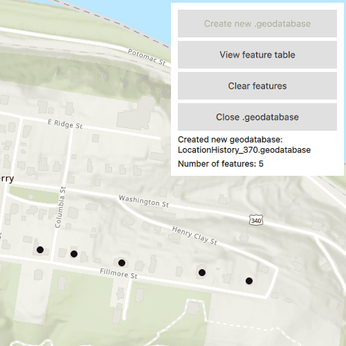
Select "Create new .geodatabase" to create a new mobile geodatabase in a temporary directory. Click or tap on the map to add features to the mobile geodatabase. Select "View feature table" to view the contents of the geodatabase feature table. Select "Clear features" to remove all features from the geodatabase feature table. Select "Close .geodatabase" to save and close the geodatabase so it is ready to be shared or uploaded to ArcGIS Online.
How it works
- Create a new
Geodatabaseat a given path that does not already exist with theGeodatabaseUtilitysingleton. - Create a
TableDescriptioncomponent and add a list ofFieldDescriptions to the table description upon component completion. - Create a
GeodatabaseFeatureTablefrom the geodatabase with theTableDescriptionusingGeodatabase.createTable(tableDescription). - Create an
ArcGISFeatureon a selected map point usingFeatureTable.createFeatureWithAttributes(attributes, point) - Add the feature to the table using
FeatureTable.addFeature(feature). - Each feature added to the feature table is committed to the mobile geodatabase file.
- Close the mobile geodatabase to safely share the ".geodatabase" file using
Geodatabase.close()
Relevant API
- ArcGISFeature
- FeatureLayer
- FeatureTable
- FieldDescription
- Geodatabase
- GeodatabaseFeatureTable
- TableDescription
Additional information
Learn more about mobile geodatabases and how to utilize them on the Mobile geodatabases page. The following mobile geodatabase behaviors are supported in the ArcGIS Maps SDK for Native Apps: annotation, attachments, attribute rules, contingent values, dimensions, domains, feature-linked annotation, subtypes, utility network and relationship classes.
Visit ArcGIS field data types to learn more about the types of fields supported.
Tags
arcgis pro, database, feature, feature table, geodatabase, mobile geodatabase, sqlite
Sample Code
// [WriteFile Name=CreateMobileGeodatabase, Category=Features]
// [Legal]
// Copyright 2022 Esri.
// Licensed under the Apache License, Version 2.0 (the "License");
// you may not use this file except in compliance with the License.
// You may obtain a copy of the License at
// http://www.apache.org/licenses/LICENSE-2.0
// Unless required by applicable law or agreed to in writing, software
// distributed under the License is distributed on an "AS IS" BASIS,
// WITHOUT WARRANTIES OR CONDITIONS OF ANY KIND, either express or implied.
// See the License for the specific language governing permissions and
// limitations under the License.
// [Legal]
import QtQuick
import Esri.ArcGISRuntime
import Esri.ArcGISExtras
import QtQuick.Controls
Rectangle {
id: rootRectangle
clip: true
width: 800
height: 600
property Geodatabase mobileGeodatabase: null
property FeatureTable featureTable: null
property bool gdbOpen: false
property int numberOfFeatures: 0
property var featureListModel: []
MapView {
id: mapView
anchors.fill: parent
Map {
id: map
initBasemapStyle: Enums.BasemapStyleArcGISTopographic
initialViewpoint: ViewpointCenter {
center: Point {
x: -77.7332
y: 39.3238
spatialReference: SpatialReference { wkid: 4326 }
}
targetScale: 10000
}
}
onMouseClicked: mouse => {
// Add a feature to the current feature table at the given mouse click or screen tap
if (!featureTable)
return;
const feature = featureTable.createFeatureWithAttributes({"collection_timestamp": new Date()}, mouse.mapPoint);
const addFeatureToFeatureTable = () => {
if (featureTable.addFeatureStatus !== Enums.TaskStatusCompleted)
return;
featureListModel.push({"oid": feature.attributes.attributeValue("oid"), "collection_timestamp": feature.attributes.attributeValue("collection_timestamp")})
tableView.model = featureListModel;
featureTable.addFeatureStatusChanged.disconnect(addFeatureToFeatureTable);
numberOfFeatures = featureTable.numberOfFeatures
}
featureTable.addFeatureStatusChanged.connect(addFeatureToFeatureTable);
featureTable.addFeature(feature);
}
}
Rectangle {
id: buttonListRectangle
anchors {
top: parent.top
right: parent.right
topMargin: 10
rightMargin: 10
}
width: 250
height: buttonColumn.height + 20
color: "#ffffff"
// Prevent mouse interaction from propagating to the MapView
MouseArea {
anchors.fill: parent
onPressed: mouse => mouse.accepted = true;
onWheel: wheel => wheel.accepted = true;
}
Column {
id: buttonColumn
anchors {
top: parent.top
left: parent.left
right: parent.right
topMargin: 10
leftMargin: 10
rightMargin: 10
}
height: children.height
spacing: 5
onHeightChanged: {
buttonListRectangle.height = height + 20
}
Button {
id: createGdbButton
anchors {
left: parent.left
right: parent.right
leftMargin: 0
rightMargin: 0
}
text: qsTr("Create new .geodatabase")
enabled: !gdbOpen
onClicked: {
createGeodatabase();
}
}
Button {
id: viewGdbTableButton
anchors {
left: parent.left
right: parent.right
leftMargin: 0
rightMargin: 0
}
text: qsTr("View feature table")
enabled: gdbOpen
onClicked: {
featureTableDisplay.visible = true;
buttonListRectangle.visible = false;
}
}
Button {
id: clearFeaturesButton
anchors {
left: parent.left
right: parent.right
leftMargin: 0
rightMargin: 0
}
text: qsTr("Clear features")
enabled: gdbOpen
onClicked: {
clearTable();
}
}
Button {
id: closeGdbButton
anchors {
left: parent.left
right: parent.right
leftMargin: 0
rightMargin: 0
}
text: qsTr("Close .geodatabase")
enabled: gdbOpen
onClicked: {
closeGeodatabase();
gdbClosedNoticeRectangle.visible = true;
buttonListRectangle.visible = false;
}
}
Text {
anchors {
left: parent.left
right: parent.right
leftMargin: 0
rightMargin: 0
}
text: mobileGeodatabase ? "Created new geodatabase:\n" + mobileGeodatabase.path.toString().split("/").pop() : "Geodatabase path not found"
font.pixelSize: 12
wrapMode: Text.WrapAnywhere
visible: gdbOpen
}
Text {
anchors {
left: parent.left
right: parent.right
leftMargin: 0
rightMargin: 0
}
text: "Number of features: " + numberOfFeatures + (numberOfFeatures === 0 ? "\n(Click or tap the map to add new features)" : "")
font.pixelSize: 12
wrapMode: Text.WordWrap
visible: gdbOpen
}
}
}
Rectangle {
id: gdbClosedNoticeRectangle
anchors.centerIn: parent
width: parent.width * 0.75
height: gdbInfoColumn.height + 20
color: "white"
border.color: "black"
clip: true
visible: false
// Prevent mouse interaction from propagating to the MapView
MouseArea {
anchors.fill: parent
onPressed: mouse => mouse.accepted = true;
onWheel: wheel => wheel.accepted = true;
}
Column {
id: gdbInfoColumn
anchors {
centerIn: parent
margins: 10
}
spacing: 10
width: parent.width - 20
height: children.height
Text {
id: gdbNameText
width: parent.width
text: "Closed and saved geodatabase to the temporary path:"
wrapMode: Text.WordWrap
}
TextEdit {
id: gdbPathText
width: parent.width
readOnly: true
selectByMouse: true
text: mobileGeodatabase ? mobileGeodatabase.path : "The geodatabase returned no path property"
wrapMode: Text.WrapAnywhere
}
Button {
id: gdbInfoClose
anchors.horizontalCenter: parent.horizontalCenter
text: "Ok"
onClicked: {
gdbClosedNoticeRectangle.visible = false;
buttonListRectangle.visible = true;
}
}
}
}
// Declare the C++ instance which creates the map etc. and supply the view
Rectangle {
id: featureTableDisplay
anchors {
verticalCenter: parent.verticalCenter
horizontalCenter: parent.horizontalCenter
}
width: parent.width - parent.width * 0.2
height: parent.height - parent.height * 0.3
color: "#80808080"
visible: false
// Prevent mouse interaction from propagating to the MapView
MouseArea {
anchors.fill: parent
onPressed: mouse => mouse.accepted = true;
onWheel: wheel => wheel.accepted = true;
}
ListView {
id: tableView
anchors {
fill: parent
margins: 10
}
ScrollBar.vertical: ScrollBar {
active: true
}
clip: true
header: Row {
height: 40
width: tableView.width
Rectangle {
color: "grey"
border.color: "black"
width: parent.width * 0.2
height: parent.height
Text {
anchors.centerIn: parent
text: "Object ID"
color: "white"
font.bold: true
wrapMode: Text.WordWrap
}
}
Rectangle {
color: "grey"
border.color: "black"
width: parent.width * 0.8
height: parent.height
Text {
anchors.centerIn: parent
text: "Timestamp"
color: "white"
font.bold: true
wrapMode: Text.WordWrap
}
}
}
model: featureListModel
delegate: Row {
height: 40
width: tableView.width
Rectangle {
color: "white"
border.color: "black"
width: parent.width * 0.2
height: parent.height
Text {
anchors.centerIn: parent
text: modelData.oid
wrapMode: Text.WordWrap
}
}
Rectangle {
color: "white"
border.color: "black"
width: parent.width * 0.8
height: parent.height
Text {
anchors.centerIn: parent
text: modelData.collection_timestamp
wrapMode: Text.WordWrap
}
}
}
}
}
Rectangle {
id: closeTableButtonRectangle
anchors {
top: parent.top
right: parent.right
topMargin: 10
rightMargin: 10
}
width: closeTableButton.width + 10
height: closeTableButton.height + 10
color: "#ffffff"
visible: featureTableDisplay.visible
// Prevent mouse interaction from propagating to the MapView
MouseArea {
anchors.fill: parent
onPressed: mouse => mouse.accepted = true;
onWheel: wheel => wheel.accepted = true;
}
Button {
id: closeTableButton
anchors.centerIn: parent
text: "Close table view"
onClicked: {
featureTableDisplay.visible = false;
buttonListRectangle.visible = true;
}
}
}
// Create a table description with which to create a feature table from the mobile geodatabase
TableDescription {
id: tableDescription
tableName: "LocationHistory"
spatialReference: SpatialReference { wkid: 4326 }
geometryType: Enums.GeometryTypePoint
hasAttachments: false
hasM: false
hasZ: false
Component.onCompleted: {
fieldDescriptions.append(ArcGISRuntimeEnvironment.createObject("FieldDescription", {name: "oid", fieldType: Enums.FieldTypeOID}));
fieldDescriptions.append(ArcGISRuntimeEnvironment.createObject("FieldDescription", {name: "collection_timestamp", fieldType: Enums.FieldTypeDate}));
}
}
// This ArcGISExtras component is used to ensure the given file path does not already exist
FileFolder {
id: fileFolder
}
function createGeodatabase() {
const path = System.temporaryFolder.url + "/LocationHistory_%1.geodatabase".arg((new Date().getTime() % 1000).toString());
// We cannot call create() with a path that already exists
if (fileFolder.fileExists(path))
return;
const createGdbStatusChanged = () => {
if (GeodatabaseUtility.createStatus === Enums.TaskStatusCompleted) {
mobileGeodatabase = GeodatabaseUtility.createResult;
// Create a feature table from the geodatabase once it has been created
createTable();
GeodatabaseUtility.createStatusChanged.disconnect(createGdbStatusChanged);
}
}
GeodatabaseUtility.createStatusChanged.connect(createGdbStatusChanged);
GeodatabaseUtility.create(path);
}
function createTable() {
gdbOpen = true;
const tableCreationStatusChanged = () => {
if (mobileGeodatabase.createTableStatus !== Enums.TaskStatusCompleted)
return;
featureTable = mobileGeodatabase.createTableResult;
const layer = ArcGISRuntimeEnvironment.createObject("FeatureLayer", {featureTable: featureTable});
map.operationalLayers.append(layer);
}
mobileGeodatabase.onCreateTableStatusChanged.connect(tableCreationStatusChanged);
mobileGeodatabase.createTable(tableDescription);
}
function closeGeodatabase() {
// Call Geodatabase.close() to safely share the ".geodatabase" file
mobileGeodatabase.close();
// Clear any information in the UI about the previous geodatabase
gdbOpen = false;
map.operationalLayers.clear();
featureListModel = [];
tableView.model = [];
numberOfFeatures = 0;
}
function clearTable() {
if (featureTable.numberOfFeatures > 0)
deleteAllFeatures();
featureListModel = [];
tableView.model = [];
}
QueryParameters {
id: params
whereClause: "1=1"
}
function deleteAllFeatures() {
const queryFeaturesCompleted = () => {
if (featureTable.queryFeaturesStatus !== Enums.TaskStatusCompleted)
return;
const results = featureTable.queryFeaturesResult;
const features = results.iterator.features;
featureTable.deleteFeatures(features);
numberOfFeatures = 0;
featureTable.queryFeaturesStatusChanged.disconnect(queryFeaturesCompleted);
}
featureTable.queryFeaturesStatusChanged.connect(queryFeaturesCompleted);
featureTable.queryFeatures(params);
}
}