Change a graphic's symbol based on the camera's proximity to it.
Use case
When showing dense datasets, it is beneficial to reduce the detail of individual points when zooming out to avoid visual clutter and to avoid data points overlapping and obscuring each other.
How to use the sample
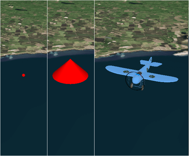
The sample starts looking at a plane. Zoom out from the plane to see it turn into a cone. Keeping zooming out and it will turn into a point.
How it works
- Create a
GraphicsOverlayobject and add it to aSceneViewobject. - Create a
DistanceCompositeSceneSymbolobject. - Create
DistanceSymbolRangeobjects specifying aSymboland the min and max distance within which the symbol should be visible. - Add the ranges to the range collection of the distance composite scene symbol.
- Create a
Graphicobject with the distance composite scene symbol at a location and add it to the graphics overlay.
Relevant API
- DistanceCompositeSceneSymbol
- Range
- RangeCollection
Offline Data
Read more about how to set up the sample's offline data here.
| Link | Local Location |
|---|---|
| Model Marker Symbol Data | <userhome>/ArcGIS/Runtime/Data/3D/Bristol/Collada/Bristol.dae |
Tags
3D, data, graphic
Sample Code
DistanceCompositeSymbol.qml
// [WriteFile Name=DistanceCompositeSymbol, Category=Scenes]
// [Legal]
// Copyright 2016 Esri.
// Licensed under the Apache License, Version 2.0 (the "License");
// you may not use this file except in compliance with the License.
// You may obtain a copy of the License at
// http://www.apache.org/licenses/LICENSE-2.0
// Unless required by applicable law or agreed to in writing, software
// distributed under the License is distributed on an "AS IS" BASIS,
// WITHOUT WARRANTIES OR CONDITIONS OF ANY KIND, either express or implied.
// See the License for the specific language governing permissions and
// limitations under the License.
// [Legal]
import QtQuick
import QtQuick.Controls
import Esri.ArcGISRuntime
import Esri.ArcGISExtras
Rectangle {
width: 800
height: 600
readonly property url dataPath: {
Qt.platform.os === "ios" ?
System.writableLocationUrl(System.StandardPathsDocumentsLocation) + "/ArcGIS/Runtime/Data/" :
System.writableLocationUrl(System.StandardPathsHomeLocation) + "/ArcGIS/Runtime/Data/"
}
// Create a scene view
SceneView {
id: sceneView
anchors.fill: parent
Component.onCompleted: {
// Set the focus on SceneView to initially enable keyboard navigation
forceActiveFocus();
}
// create a scene...scene is a default property of sceneview
// and thus will get added to the sceneview
Scene {
// add a basemap
Basemap {
initStyle: Enums.BasemapStyleArcGISImageryStandard
}
// add a surface...surface is a default property of scene
Surface {
// add an arcgis tiled elevation source...elevation source is a default property of surface
ArcGISTiledElevationSource {
url: "https://elevation3d.arcgis.com/arcgis/rest/services/WorldElevation3D/Terrain3D/ImageServer"
}
}
}
// add an orbit camera controller to lock the camera to the graphic
cameraController: OrbitGeoElementCameraController {
targetGeoElement: aircraftGraphic
cameraPitchOffset: 80
cameraHeadingOffset: -30
cameraDistance: 200
}
GraphicsOverlay {
id: graphicsOverlay
LayerSceneProperties {
surfacePlacement: Enums.SurfacePlacementRelative
}
Graphic {
id: aircraftGraphic
geometry: point
symbol: distanceCompositeSceneSymbol
}
}
}
Point {
id: point
x: -2.708471
y: 56.096575
z: 5000
spatialReference: SpatialReference { wkid: 4326 }
}
//! [create a distance composite scene symbol]
DistanceCompositeSceneSymbol {
id: distanceCompositeSceneSymbol
// create a distance symbol range with a model scene symbol
DistanceSymbolRange {
minDistance: 0
maxDistance: 999
//! [model scene symbol]
ModelSceneSymbol {
id: mms
url: dataPath + "3D/Bristol/Collada/Bristol.dae"
scale: 5.0
heading: 180
}
//! [model scene symbol]
}
// create a distance symbol range with a simple marker scene symbol
DistanceSymbolRange {
minDistance: 1000
maxDistance: 1999
//! [simple marker scene symbol]
SimpleMarkerSceneSymbol {
style: Enums.SimpleMarkerSceneSymbolStyleCone
color: "red"
height: 75
width: 75
depth: 75
}
//! [simple marker scene symbol]
}
// create a distance symbol range with a simple marker symbol
DistanceSymbolRange {
minDistance: 2000
maxDistance: 0
SimpleMarkerSymbol {
style: Enums.SimpleMarkerSymbolStyleCircle
color: "red"
size: 10
}
}
}
//! [create a distance composite scene symbol]
}