List features related to a selected feature.
Use case
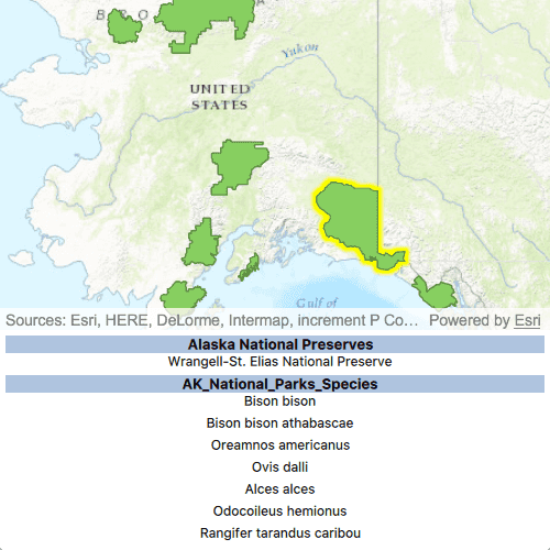
Related features are useful for managing relational information, like what you would store in a relational database management system (RDBMS). You can define relationship between records as one-to-one, one-to-many, or many-to-one. For example, you could model inspections and facilities as a many-to-one relationship. Then, for any facility feature, you could list related inspection features.
How to use the sample
Click on a feature to select it. The related features will be displayed in a list.
How it works
- With a
Feature, callqueryRelatedFeatureson the feature's feature table. - Iterate over the result's collection of
queryRelatedFeaturesResultsobjects to get the related features and add them to a list.
Relevant API
- Feature
- FeatureTable
- FeatureQueryResult
- FeatureTable.queryRelatedFeatures
- RelatedFeatureQueryResult
Tags
features, identify, query, related, relationship, search
Sample Code
ListRelatedFeatures.qml
// [WriteFile Name=ListRelatedFeatures, Category=Features]
// [Legal]
// Copyright 2017 Esri.
// Licensed under the Apache License, Version 2.0 (the "License");
// you may not use this file except in compliance with the License.
// You may obtain a copy of the License at
// http://www.apache.org/licenses/LICENSE-2.0
// Unless required by applicable law or agreed to in writing, software
// distributed under the License is distributed on an "AS IS" BASIS,
// WITHOUT WARRANTIES OR CONDITIONS OF ANY KIND, either express or implied.
// See the License for the specific language governing permissions and
// limitations under the License.
// [Legal]
import QtQuick
import QtQuick.Controls
import Esri.ArcGISRuntime
Rectangle {
id: rootRectangle
clip: true
width: 800
height: 600
property FeatureLayer alaskaNationalParks: null
MapView {
id: mapView
anchors.fill: parent
Component.onCompleted: {
// Set the focus on MapView to initially enable keyboard navigation
forceActiveFocus();
}
SelectionProperties {
color: "yellow"
}
// bind the insets to the attribute view so the attribution text shows when the view expands
viewInsets.bottom: attributeView.height
Map {
id: map
initUrl: "https://arcgis.com/home/item.html?id=dcc7466a91294c0ab8f7a094430ab437"
onLoadStatusChanged: {
if (loadStatus !== Enums.LoadStatusLoaded)
return;
// get the Alaska National Parks feature layer
map.operationalLayers.forEach(fl => {
if (fl.name.indexOf("- Alaska National Parks") !== -1) {
alaskaNationalParks = fl;
}
});
}
}
onMouseClicked: mouse => {
// hide the attribute view
attributeView.height = 0;
// clear the list model
relatedFeaturesModel.clear();
// create objects required to do a selection with a query
const clickPoint = mouse.mapPoint;
const mapTolerance = 10 * mapView.unitsPerDIP;
const envelope = ArcGISRuntimeEnvironment.createObject("Envelope", {
xMin: clickPoint.x - mapTolerance,
yMin: clickPoint.y - mapTolerance,
xMax: clickPoint.x + mapTolerance,
yMax: clickPoint.y + mapTolerance,
spatialReference: map.spatialReference
});
const queryParams = ArcGISRuntimeEnvironment.createObject("QueryParameters");
queryParams.geometry = envelope;
queryParams.spatialRelationship = Enums.SpatialRelationshipIntersects;
// clear any selections
alaskaNationalParks.clearSelection();
// select features
alaskaNationalParks.selectFeaturesWithQuery(queryParams, Enums.SelectionModeNew);
}
}
Connections {
target: alaskaNationalParks
function onSelectFeaturesStatusChanged() {
if (alaskaNationalParks.selectFeaturesStatus === Enums.TaskStatusErrored) {
const errorString = "Error: %1".arg(alaskaNationalParks.error.message);
msgDialog.text = errorString;
msgDialog.open();
console.log(errorString);
} else if (alaskaNationalParks.selectFeaturesStatus === Enums.TaskStatusCompleted) {
const featureQueryResult = alaskaNationalParks.selectFeaturesResult;
// iterate over features returned
while (featureQueryResult.iterator.hasNext) {
const arcGISFeature = featureQueryResult.iterator.next();
const selectedTable = arcGISFeature.featureTable;
// connect signal
selectedTable.queryRelatedFeaturesStatusChanged.connect(()=> {
if (selectedTable.queryRelatedFeaturesStatus !== Enums.TaskStatusCompleted)
return;
const relatedFeatureQueryResultList = selectedTable.queryRelatedFeaturesResults;
// iterate over returned RelatedFeatureQueryResults
for (let i = 0; i < relatedFeatureQueryResultList.length; i++) {
// iterate over Features returned
const iter = relatedFeatureQueryResultList[i].iterator;
while (iter.hasNext) {
const feat = iter.next();
const displayFieldName = feat.featureTable.layerInfo.displayFieldName;
const serviceLayerName = feat.featureTable.layerInfo.serviceLayerName;
const displayFieldValue = feat.attributes.attributeValue(displayFieldName);
// add the related feature info to a list model
const listElement = {
"displayFieldName" : displayFieldName,
"displayFieldValue" : displayFieldValue,
"serviceLayerName" : serviceLayerName
};
relatedFeaturesModel.append(listElement);
}
}
// show the attribute view
attributeView.height = 200
});
// zoom to the feature
mapView.setViewpointGeometryAndPadding(arcGISFeature.geometry, 100)
// query related features
selectedTable.queryRelatedFeatures(arcGISFeature);
}
}
}
}
Rectangle {
id: attributeView
anchors {
left: parent.left
right: parent.right
bottom: parent.bottom
}
height: 0
// Animate the expand and collapse of the legend
Behavior on height {
SpringAnimation {
spring: 3
damping: 0.4
}
}
ListView {
anchors {
fill: parent
margins: 5
}
clip: true
model: relatedFeaturesModel
spacing: 5
// Create delegate to display the attributes
delegate: Rectangle {
width: rootRectangle.width
height: childrenRect.height
color: "transparent"
Text {
anchors.horizontalCenter: parent.horizontalCenter
anchors.margins: 10
text: displayFieldValue
font.pixelSize: 12
}
}
// Create a section to separate features by table
section {
property: "serviceLayerName"
criteria: ViewSection.FullString
labelPositioning: ViewSection.CurrentLabelAtStart | ViewSection.InlineLabels
delegate: Rectangle {
width: rootRectangle.width
height: childrenRect.height
color: "lightsteelblue"
Text {
anchors.horizontalCenter: parent.horizontalCenter
text: section
font {
bold: true
pixelSize: 13
}
}
}
}
}
}
ListModel {
id: relatedFeaturesModel
}
Dialog {
id: msgDialog
modal: true
x: Math.round(parent.width - width) / 2
y: Math.round(parent.height - height) / 2
standardButtons: Dialog.Ok
property alias text : textLabel.text
Text {
id: textLabel
text: "Executing geoprocessing failed."
}
}
}