Find features in a feature table which match an SQL query.
Use case
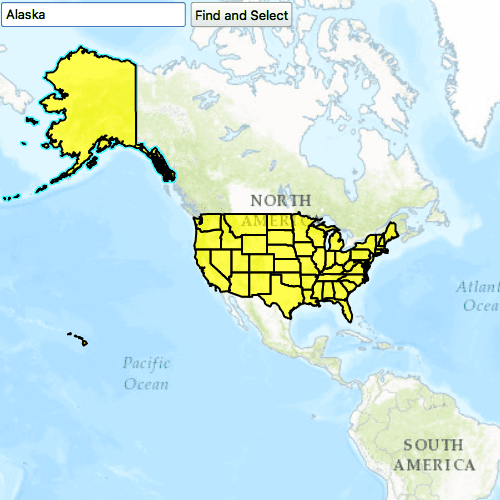
Query expressions can be used in ArcGIS to select a subset of features from a feature table. This is most useful in large or complicated data sets. A possible use case might be on a feature table marking the location of street furniture through a city. A user may wish to query by a TYPE column to return "benches". In this sample, we query a U.S. state by STATE_NAME from a feature table containing all U.S. states.
How to use the sample
Input the name of a U.S. state into the text field. When you click "Find and Select", a query is performed and the matching features are highlighted or an error is returned.
How it works
Enter part of a USA state name in the text box and select the Find and Select button. The sample uses the text from the text box to query for the state name, and will select the features returned from the query. Also, the map view will pan and zoom to the first feature in the list of selected features.
- Create a
ServiceFeatureTableusing the URL of a feature service. - Create a
QueryParameterswith a where clause specified by settingwhereClause. - Perform the query using
queryFeatures(query)on the service feature table. - When complete, the query will return a
FeatureQueryResultwhich can be iterated over to get the matching features.
Relevant API
- FeatureLayer
- FeatureQueryResult
- QueryParameters
- ServiceFeatureTable
About the data
This sample uses U.S. State polygon features from the USA 2016 Daytime Population feature service.
Tags
Search and Query
Sample Code
// [WriteFile Name=FeatureLayer_Query, Category=Features]
// [Legal]
// Copyright 2016 Esri.
// Licensed under the Apache License, Version 2.0 (the "License");
// you may not use this file except in compliance with the License.
// You may obtain a copy of the License at
// http://www.apache.org/licenses/LICENSE-2.0
// Unless required by applicable law or agreed to in writing, software
// distributed under the License is distributed on an "AS IS" BASIS,
// WITHOUT WARRANTIES OR CONDITIONS OF ANY KIND, either express or implied.
// See the License for the specific language governing permissions and
// limitations under the License.
// [Legal]
import QtQuick
import QtQuick.Controls
import Esri.ArcGISRuntime
Rectangle {
width: 800
height: 600
// Map view UI presentation at top
MapView {
id: mapView
anchors.fill: parent
wrapAroundMode: Enums.WrapAroundModeDisabled
Component.onCompleted: {
// Set the focus on MapView to initially enable keyboard navigation
forceActiveFocus();
}
Map {
id: map
Basemap {
initStyle: Enums.BasemapStyleArcGISTopographic
}
initialViewpoint: viewPoint
FeatureLayer {
id: featureLayer
maxScale: 10000
// default property (renderer)
SimpleRenderer {
SimpleFillSymbol {
style: Enums.SimpleFillSymbolStyleSolid
color: Qt.rgba(1, 1, 0, 0.6)
// default property (outline)
SimpleLineSymbol {
style: Enums.SimpleLineSymbolStyleSolid
color: "black"
width: 2.0
antiAlias: true
}
}
}
// feature table
ServiceFeatureTable {
id: featureTable
url: "https://services.arcgis.com/jIL9msH9OI208GCb/arcgis/rest/services/USA_Daytime_Population_2016/FeatureServer/0"
}
}
}
// initial viewPoint
ViewpointCenter {
id: viewPoint
center: Point {
x: -11e6
y: 5e6
spatialReference: SpatialReference {
wkid: 102100
}
}
targetScale: 9e7
}
Row {
id: findRow
anchors {
top: parent.top
bottom: map.top
left: parent.left
right: parent.right
margins: 5
}
spacing: 5
TextField {
id: findText
width: parent.width * 0.25
placeholderText: "Enter a state name to select"
inputMethodHints: Qt.ImhNoPredictiveText
selectByMouse: true
validator: RegularExpressionValidator{ regularExpression: /^[a-zA-Z ]*$/ }
Keys.onReturnPressed: {
btn.clicked();
}
}
Button {
id: btn
text: "Find and Select"
enabled: featureTable.loadStatus === Enums.LoadStatusLoaded
onClicked: {
const queryString = `LOWER(STATE_NAME) LIKE LOWER('${findText.text}%')`;
queryFeatures(queryString, featureTable) // query the table
.then(result=>selectResults(result, featureLayer)) // then select the features
.then(features=>mapView.setViewpointGeometryAndPadding(features[0].geometry, 30)) // then zoom to the select feature
.catch(error=>textLabel.text = error.message);
}
}
}
Dialog {
id: errorMsgDialog
modal: true
x: Math.round(parent.width - width) / 2
y: Math.round(parent.height - height) / 2
standardButtons: Dialog.Ok
property alias text : textLabel.text
Text {
id: textLabel
onTextChanged: {
if (text.length > 0)
errorMsgDialog.open();
}
}
}
}
function selectResults(result, layer) {
return new Promise(
(resolve, reject)=>{
// clear any previous selection
layer.clearSelection();
// get the features
const features = Array.from(result.iterator.features);
if (features.length === 0) {
const msg = "No state named " + findText.text.toUpperCase() + " exists."
reject({message: msg});
}
// select the features
// The ideal way to select features is to call featureLayer.selectFeaturesWithQuery(), which will
// automatically select the features based on your query. This is just a way to show you operations
// that you can do with query results. Refer to API doc for more details.
layer.selectFeatures(features);
resolve(features)
});
}
function queryFeatures(searchString, table){
return new Promise(
(resolve, reject)=>{
let taskId;
let parameters = ArcGISRuntimeEnvironment.createObject("QueryParameters");
parameters.whereClause = searchString;
const featureStatusChanged = ()=> {
switch (table.queryFeaturesStatus) {
case Enums.TaskStatusCompleted:
table.queryFeaturesStatusChanged.disconnect(featureStatusChanged);
const result = table.queryFeaturesResults[taskId];
if (result) {
resolve(result);
} else {
reject({message: "The query finished but there was no result for this taskId", taskId: taskId});
}
break;
case Enums.TaskStatusErrored:
table.queryFeaturesStatusChanged.disconnect(featureStatusChanged);
if (table.error) {
reject(table.error);
} else {
reject({message: table.tableName + ": query task errored++++"});
}
break;
default:
break;
}
}
table.queryFeaturesStatusChanged.connect(featureStatusChanged);
taskId = table.queryFeatures(parameters);
});
}
}