Display annotation from a feature service URL.
Use case
Annotation is useful for displaying text that you don't want to move or resize when the map is panned or zoomed (unlike labels which will move and resize). You can use annotation to place text at a fixed size, position, orientation, font, and so on. You may choose to do this for cartographic reasons or because the exact placement of the text is important.
How to use the sample
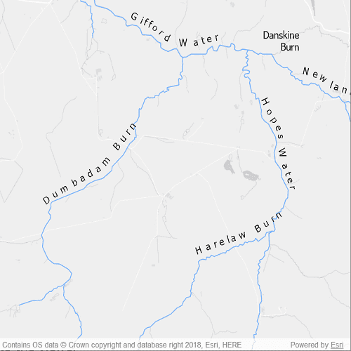
Pan and zoom to see names of waters and burns in a small region of Scotland.
How it works
- Create a
Mapwith a light gray canvas and a viewpoint near the data. - Create a
ServiceFeatureTablewith a URL. - Create an
AnnotationLayerfrom the feature table and add it to the map.
Relevant API
- AnnotationLayer
- FeatureLayer
About the data
Data derived from OS OpenRivers. Contains OS data © Crown copyright and database right 2018.
The annotation layer contains two sublayers of rivers in East Lothian, Scotland, which were set by the author to only be visible within the following scale ranges:
- Water (1:50,000 - 1:100,000) - A large stream, as defined in the Scots language
- Burn (1:25,000 - 1:75,000) - A brook or small stream, as defined in the Scots language
Additional information
Annotation is only supported from feature services hosted on an ArcGIS Enterprise server.
Tags
annotation, cartography, labels, placement, reference scale, text, utility
Sample Code
// [WriteFile Name=DisplayAnnotation, Category=Layers]
// [Legal]
// Copyright 2020 Esri.
// Licensed under the Apache License, Version 2.0 (the "License");
// you may not use this file except in compliance with the License.
// You may obtain a copy of the License at
// http://www.apache.org/licenses/LICENSE-2.0
// Unless required by applicable law or agreed to in writing, software
// distributed under the License is distributed on an "AS IS" BASIS,
// WITHOUT WARRANTIES OR CONDITIONS OF ANY KIND, either express or implied.
// See the License for the specific language governing permissions and
// limitations under the License.
// [Legal]
import QtQuick
import Esri.ArcGISRuntime
Rectangle {
id: rootRectangle
clip: true
width: 800
height: 600
MapView {
id: mapView
anchors.fill: parent
Component.onCompleted: {
// Set the focus on MapView to initially enable keyboard navigation
forceActiveFocus();
}
Map {
Basemap {
initStyle: Enums.BasemapStyleArcGISLightGray
}
FeatureLayer {
ServiceFeatureTable {
url: "https://services1.arcgis.com/6677msI40mnLuuLr/arcgis/rest/services/East_Lothian_Rivers/FeatureServer/0"
}
}
AnnotationLayer {
ServiceFeatureTable {
url: "https://sampleserver6.arcgisonline.com/arcgis/rest/services/RiversAnnotation/FeatureServer/0"
}
}
ViewpointCenter {
// Specify the center Point
Point {
x: -2.725610
y: 55.882436
SpatialReference { wkid: 4326 }
}
// Specify the scale
targetScale: 50000
}
}
}
}