Download tiles to a local tile cache file stored on the device.
Use case
Field workers with limited network connectivity can use exported tiles as a basemap for use offline.
How to use the sample
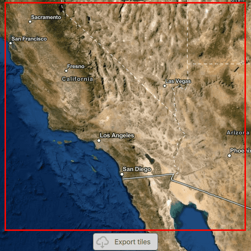
Pan and zoom into the desired area, making sure the area is within the red boundary. Click the 'Export tiles' button to start the process. The application will export tiles from the raster imagery baselayer and not include the vector labels baselayer from the Imagery BasemapStyle. On successful completion you will see a preview of the downloaded tile package.
How it works
- Create and load a Map with a basemap style that includes a raster base layer.
- Create an
ExportTileCacheTaskwith a URL from a raster base layer of a basemap. - Create default
ExportTileCacheParametersfor the task, specifying extent, minimum scale and maximum scale. Limiting the difference between the minimum and maximum scales will decrease the size of the resulting tile package and the time it takes to create. - Use the parameters and a path to create an
ExportTileCacheJobfrom the task. - Start the job, and when it completes successfully, get the resulting
TileCache. - Use the tile cache to create an
ArcGISTiledLayer, and display it in the map.
Relevant API
- ArcGISTiledLayer
- ExportTileCacheJob
- ExportTileCacheParameters
- ExportTileCacheTask
- TileCache
Additional information
ArcGIS tiled layers do not support reprojection, query, select, identify, or editing. See the Layer types discussion in the developers guide to learn more about the characteristics of ArcGIS tiled layers.
At this time, ExportTileCacheTask only supports raster layers.
Tags
cache, download, offline
Sample Code
// [WriteFile Name=ExportTiles, Category=Layers]
// [Legal]
// Copyright 2016 Esri.
// Licensed under the Apache License, Version 2.0 (the "License");
// you may not use this file except in compliance with the License.
// You may obtain a copy of the License at
// http://www.apache.org/licenses/LICENSE-2.0
// Unless required by applicable law or agreed to in writing, software
// distributed under the License is distributed on an "AS IS" BASIS,
// WITHOUT WARRANTIES OR CONDITIONS OF ANY KIND, either express or implied.
// See the License for the specific language governing permissions and
// limitations under the License.
// [Legal]
import QtQuick
import QtQuick.Controls
import Esri.ArcGISRuntime
import Esri.ArcGISExtras
Rectangle {
width: 800
height: 600
readonly property url outputTileCache: System.temporaryFolder.url + "/TileCacheQml_%1.tpkx".arg(new Date().getTime().toString())
property Envelope tileCacheExtent: null
property string statusText: ""
property ExportTileCacheParameters params
property int exportTileCacheProgress: 0
// Create MapView that contains a Map
MapView {
id: mapView
anchors.fill: parent
Component.onCompleted: {
// Set the focus on MapView to initially enable keyboard navigation
forceActiveFocus();
}
Map {
id: map
// Add an imagery basemap to the map and get the url of the raster baselayer once it has loaded
Basemap {
initStyle: Enums.BasemapStyleArcGISImagery
onLoadStatusChanged: {
if (loadStatus !== Enums.LoadStatusLoaded)
return;
exportTask.url = baseLayers.get(0).url;
}
}
initialViewpoint: ViewpointCenter {
center: Point {
x: -117
y: 35
spatialReference: SpatialReference { wkid: 4326 }
}
targetScale: 1e7
}
}
}
// Create ExportTileCacheTask
//! [ExportTiles ExportTileCacheTask]
ExportTileCacheTask {
id: exportTask
property var exportJob
onCreateDefaultExportTileCacheParametersStatusChanged: {
if (createDefaultExportTileCacheParametersStatus === Enums.TaskStatusCompleted) {
params = defaultExportTileCacheParameters;
// export the cache with the parameters
executeExportTileCacheTask(params);
}
}
function generateDefaultParameters() {
// generate the default parameters with the extent and map scales specified
exportTask.createDefaultExportTileCacheParameters(tileCacheExtent, mapView.mapScale, mapView.mapScale/10);
}
function executeExportTileCacheTask(params) {
// execute the asynchronous task and obtain the job
exportJob = exportTask.exportTileCache(params, outputTileCache);
// check if job is valid
if (exportJob) {
// show the export window
exportWindow.visible = true;
// connect to the job's status changed signal to know once it is done
exportJob.statusChanged.connect(updateJobStatus);
exportJob.progressChanged.connect(updateExportProgress);
exportJob.start();
} else {
exportWindow.visible = true;
statusText = "Export failed";
exportWindow.hideWindow(5000);
}
}
function updateJobStatus() {
switch(exportJob.jobStatus) {
case Enums.JobStatusFailed:
statusText = "Export failed";
exportWindow.hideWindow(5000);
break;
case Enums.JobStatusNotStarted:
statusText = "Job not started";
break;
case Enums.JobStatusPaused:
statusText = "Job paused";
break;
case Enums.JobStatusStarted:
statusText = "In progress...";
break;
case Enums.JobStatusSucceeded:
statusText = "Adding TPKX...";
exportWindow.hideWindow(1500);
displayOutputTileCache(exportJob.result);
break;
default:
break;
}
}
function updateExportProgress() {
exportTileCacheProgress = exportJob.progress;
}
function displayOutputTileCache(tileCache) {
// create a new tiled layer from the output tile cache
const tiledLayer = ArcGISRuntimeEnvironment.createObject("ArcGISTiledLayer", { tileCache: tileCache } );
// create a new basemap with the tiled layer
const basemap = ArcGISRuntimeEnvironment.createObject("Basemap");
basemap.baseLayers.append(tiledLayer);
// set the new basemap on the map
map.basemap = basemap;
// zoom to the new layer and hide window once loaded
tiledLayer.loadStatusChanged.connect(()=> {
if (tiledLayer.loadStatus === Enums.LoadStatusLoaded) {
extentRectangle.visible = false;
downloadButton.visible = false;
const prevMapScale = mapView.mapScale;
mapView.setViewpointScale(prevMapScale * .5);
map.minScale = prevMapScale;
map.maxScale = prevMapScale / 10;
}
});
}
Component.onDestruction: {
if (exportJob) {
exportJob.statusChanged.disconnect(updateJobStatus);
exportJob.progressChanged.disconnect(updateExportProgress);
}
}
}
//! [ExportTiles ExportTileCacheTask]
Rectangle {
id: extentRectangle
anchors.centerIn: parent
width: parent.width - (50)
height: parent.height - (125)
color: "transparent"
border {
color: "red"
width: 3
}
}
// Create the download button to export the tile cache
Rectangle {
id: downloadButton
property bool pressed: false
anchors {
horizontalCenter: parent.horizontalCenter
bottom: parent.bottom
bottomMargin: 23
}
width: 130
height: 35
color: pressed ? "#959595" : "#D6D6D6"
radius: 5
border {
color: "#585858"
width: 1
}
Row {
anchors.fill: parent
spacing: 5
Image {
width: 38
height: width
source: "qrc:/Samples/Layers/ExportTiles/download.png"
}
Text {
anchors.verticalCenter: parent.verticalCenter
text: "Export tiles"
font.pixelSize: 14
color: "#474747"
}
}
MouseArea {
anchors.fill: parent
onPressed: downloadButton.pressed = true
onReleased: downloadButton.pressed = false
onClicked: {
getRectangleEnvelope();
}
function getRectangleEnvelope() {
const corner1 = mapView.screenToLocation(extentRectangle.x, extentRectangle.y);
const corner2 = mapView.screenToLocation((extentRectangle.x + extentRectangle.width), (extentRectangle.y + extentRectangle.height));
const envBuilder = ArcGISRuntimeEnvironment.createObject("EnvelopeBuilder");
envBuilder.setCorners(corner1, corner2);
tileCacheExtent = GeometryEngine.project(envBuilder.geometry, Factory.SpatialReference.createWebMercator());
exportTask.generateDefaultParameters();
}
}
}
// Create a window to display the export window
Rectangle {
id: exportWindow
anchors.fill: parent
color: "transparent"
visible: false
clip: true
Rectangle {
anchors.fill: parent
color: "#60000000"
}
MouseArea {
anchors.fill: parent
onClicked: mouse => mouse.accepted = true
onWheel: wheel => wheel.accepted = true
}
Rectangle {
anchors.centerIn: parent
width: 140
height: 145
color: "lightgrey"
opacity: 0.8
radius: 5
border {
color: "#4D4D4D"
width: 1
}
Column {
anchors {
fill: parent
margins: 10
}
spacing: 10
BusyIndicator {
anchors.horizontalCenter: parent.horizontalCenter
}
Text {
anchors.horizontalCenter: parent.horizontalCenter
text: statusText
font.pixelSize: 16
}
Text {
anchors.horizontalCenter: parent.horizontalCenter
text: exportTileCacheProgress + "% Completed"
font.pixelSize: 16
}
}
}
Timer {
id: hideWindowTimer
onTriggered: exportWindow.visible = false;
}
function hideWindow(time) {
hideWindowTimer.interval = time;
hideWindowTimer.restart();
}
}
}