Generate a local geodatabase from an online feature service.
Use case
Generating geodatabases is the first step toward taking a feature service offline. It allows you to save features locally for offline display.
How to use the sample
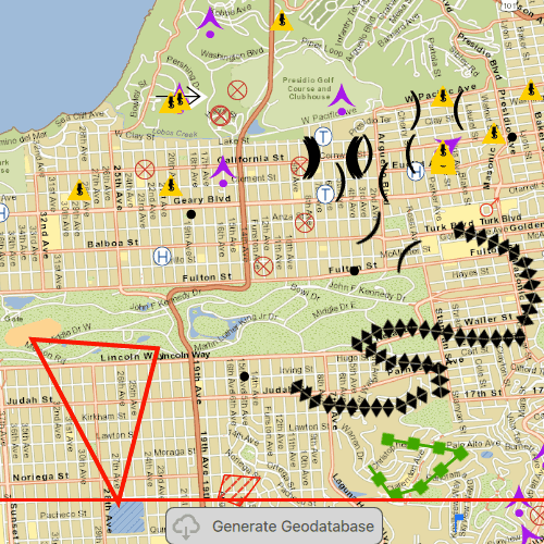
Zoom to any extent. Then click the generate button to generate a geodatabase of features from a feature service filtered to the current extent. A red outline will show the extent used. The job's progress is shown while the geodatabase is generated. When complete, the map will reload with only the layers in the geodatabase, clipped to the extent.
How it works
- Create a
GeodatabaseSyncTaskwith the URL of the feature service and load it. - Create
GenerateGeodatabaseParametersspecifying the extent and whether to include attachments. - Create a
GenerateGeodatabaseJobwithgeodatabaseSyncTask.generateGeodatabase(parameters, downloadPath). Start the job withjob.start(). - When the job is done,
job.geodatabasewill return the geodatabase. Inside the geodatabase are feature tables which can be used to add feature layers to the map. - Call
syncTask.unregisterGeodatabase(geodatabase)after generation when you're not planning on syncing changes to the service.
Relevant API
- GenerateGeodatabaseJob
- GenerateGeodatabaseParameters
- Geodatabase
- GeodatabaseSyncTask
Offline Data
To set up the sample's offline data, see the Use offline data in the samples section of the Qt Samples repository overview.
| Link | Local Location |
|---|---|
| San Francisco Streets TPKX | <userhome>/ArcGIS/Runtime/Data/tpkx/SanFrancisco.tpkx |
Tags
disconnected, local geodatabase, offline, replica, sync
Sample Code
GenerateGeodatabaseReplicaFromFeatureService.qml
// [WriteFile Name=GenerateGeodatabaseReplicaFromFeatureService, Category=Features]
// [Legal]
// Copyright 2016 Esri.
// Licensed under the Apache License, Version 2.0 (the "License");
// you may not use this file except in compliance with the License.
// You may obtain a copy of the License at
// http://www.apache.org/licenses/LICENSE-2.0
// Unless required by applicable law or agreed to in writing, software
// distributed under the License is distributed on an "AS IS" BASIS,
// WITHOUT WARRANTIES OR CONDITIONS OF ANY KIND, either express or implied.
// See the License for the specific language governing permissions and
// limitations under the License.
// [Legal]
import QtQuick
import QtQuick.Controls
import Esri.ArcGISRuntime
import Esri.ArcGISExtras
Rectangle {
width: 800
height: 600
readonly property url dataPath: {
Qt.platform.os === "ios" ?
System.writableLocationUrl(System.StandardPathsDocumentsLocation) + "/ArcGIS/Runtime/Data/" :
System.writableLocationUrl(System.StandardPathsHomeLocation) + "/ArcGIS/Runtime/Data/"
}
readonly property url outputGdb: System.temporaryFolder.url + "/WildfireQml_%1.geodatabase".arg(new Date().getTime().toString())
readonly property string featureServiceUrl: "https://sampleserver6.arcgisonline.com/arcgis/rest/services/Sync/WildfireSync/FeatureServer"
property Envelope generateExtent: null
property var generateLayerOptions: []
property string statusText: ""
// Map view UI presentation at top
MapView {
id: mapView
anchors.fill: parent
Component.onCompleted: {
// Set the focus on MapView to initially enable keyboard navigation
forceActiveFocus();
}
Map {
id: map
//! [display tiled layer from tile cache]
Basemap {
ArcGISTiledLayer {
TileCache {
path: dataPath + "tpkx/SanFrancisco.tpkx"
}
}
}
//! [display tiled layer from tile cache]
onLoadStatusChanged: {
if (loadStatus === Enums.LoadStatusLoaded) {
// add the feature layers
geodatabaseSyncTask.load();
}
}
// set an initial viewpoint
ViewpointExtent {
Envelope {
xMax: -122.43843016064368
xMin: -122.50017717584528
yMax: 37.81638388695054
yMin: 37.745000054347535
spatialReference: Factory.SpatialReference.createWgs84()
}
}
}
}
//! [Features GenerateGeodatabase Create GeodatabaseSyncTask]
// create the GeodatabaseSyncTask to generate the local geodatabase
GeodatabaseSyncTask {
id: geodatabaseSyncTask
url: featureServiceUrl
property var generateJob
onLoadStatusChanged: {
if (loadStatus === Enums.LoadStatusLoaded) {
const idInfos = featureServiceInfo.layerInfos;
for (let i = 0; i < idInfos.length; i++) {
// add the layer to the map
const featureLayerUrl = featureServiceInfo.url + "/" + idInfos[i].infoId;
const serviceFeatureTable = ArcGISRuntimeEnvironment.createObject("ServiceFeatureTable", {url: featureLayerUrl});
const featureLayer = ArcGISRuntimeEnvironment.createObject("FeatureLayer", {featureTable: serviceFeatureTable});
map.operationalLayers.append(featureLayer);
// add a new GenerateLayerOption to array for use in the GenerateGeodatabaseParameters
const layerOption = ArcGISRuntimeEnvironment.createObject("GenerateLayerOption", {layerId: idInfos[i].infoId});
generateLayerOptions.push(layerOption);
generateParameters.layerOptions = generateLayerOptions;
}
}
}
function executeGenerate() {
// execute the asynchronous task and obtain the job
generateJob = generateGeodatabase(generateParameters, outputGdb);
// check if the job is valid
if (generateJob) {
// show the generate window
generateWindow.visible = true;
// connect to the job's status changed signal to know once it is done
generateJob.statusChanged.connect(updateGenerateJobStatus);
// start the job
generateJob.start();
} else {
// a valid job was not obtained, so show an error
generateWindow.visible = true;
statusText = "Generate failed";
generateWindow.hideWindow(5000);
}
}
function updateGenerateJobStatus() {
switch(generateJob.jobStatus) {
case Enums.JobStatusFailed:
statusText = "Generate failed";
generateWindow.hideWindow(5000);
break;
case Enums.JobStatusNotStarted:
statusText = "Job not started";
break;
case Enums.JobStatusPaused:
statusText = "Job paused";
break;
case Enums.JobStatusStarted:
statusText = "In progress...";
break;
case Enums.JobStatusSucceeded:
statusText = "Complete";
generateWindow.hideWindow(1500);
displayLayersFromGeodatabase(generateJob.geodatabase);
break;
default:
break;
}
}
function displayLayersFromGeodatabase(geodatabase) {
// remove the original online feature layers
map.operationalLayers.clear();
// load the geodatabase to access the feature tables
geodatabase.loadStatusChanged.connect(()=> {
if (geodatabase.loadStatus === Enums.LoadStatusLoaded) {
// create a feature layer from each feature table, and add to the map
for (let i = 0; i < geodatabase.geodatabaseFeatureTables.length; i++) {
const featureTable = geodatabase.geodatabaseFeatureTables[i];
const featureLayer = ArcGISRuntimeEnvironment.createObject("FeatureLayer");
featureLayer.featureTable = featureTable;
map.operationalLayers.append(featureLayer);
}
// unregister geodatabase since there will be no edits uploaded
geodatabaseSyncTask.unregisterGeodatabase(geodatabase);
// hide the extent rectangle and download button
extentRectangle.visible = false;
downloadButton.visible = false;
}
});
geodatabase.load();
}
Component.onDestruction: {
if (generateJob) {
generateJob.statusChanged.disconnect(updateGenerateJobStatus);
}
}
}
// create the generate geodatabase parameters
GenerateGeodatabaseParameters {
id: generateParameters
extent: generateExtent
outSpatialReference: SpatialReference { wkid: 3857 }
returnAttachments: false
}
//! [Features GenerateGeodatabase Create GeodatabaseSyncTask]
// create an extent rectangle for the output geodatabase
Rectangle {
id: extentRectangle
anchors.centerIn: parent
width: parent.width - (50)
height: parent.height - (125)
color: "transparent"
border {
color: "red"
width: 3
}
}
// Create the download button to generate geodatabase
Rectangle {
id: downloadButton
property bool pressed: false
anchors {
horizontalCenter: parent.horizontalCenter
bottom: parent.bottom
bottomMargin: 23
}
width: 200
height: 35
color: pressed ? "#959595" : "#D6D6D6"
radius: 8
border {
color: "#585858"
width: 1
}
Row {
anchors.fill: parent
spacing: 5
Image {
width: 38
height: width
source: "qrc:/Samples/Features/GenerateGeodatabaseReplicaFromFeatureService/download.png"
}
Text {
anchors.verticalCenter: parent.verticalCenter
text: "Generate Geodatabase"
font.pixelSize: 14
color: "#474747"
}
}
MouseArea {
anchors.fill: parent
onPressed: downloadButton.pressed = true
onReleased: downloadButton.pressed = false
onClicked: {
getRectangleEnvelope();
geodatabaseSyncTask.executeGenerate();
}
function getRectangleEnvelope() {
const corner1 = mapView.screenToLocation(extentRectangle.x, extentRectangle.y);
const corner2 = mapView.screenToLocation((extentRectangle.x + extentRectangle.width), (extentRectangle.y + extentRectangle.height));
const envBuilder = ArcGISRuntimeEnvironment.createObject("EnvelopeBuilder");
envBuilder.setCorners(corner1, corner2);
generateExtent = GeometryEngine.project(envBuilder.geometry, Factory.SpatialReference.createWebMercator());
}
}
}
// Create a window to display the generate window
Rectangle {
id: generateWindow
anchors.fill: parent
color: "transparent"
clip: true
visible: false
Rectangle {
anchors.fill: parent
color: "#60000000"
}
MouseArea {
anchors.fill: parent
onClicked: mouse => mouse.accepted = true
onWheel: wheel => wheel.accepted = true
}
Rectangle {
anchors.centerIn: parent
width: 125
height: 100
color: "lightgrey"
opacity: 0.8
radius: 5
border {
color: "#4D4D4D"
width: 1
}
Column {
anchors {
fill: parent
margins: 10
}
spacing: 10
BusyIndicator {
anchors.horizontalCenter: parent.horizontalCenter
}
Text {
anchors.horizontalCenter: parent.horizontalCenter
text: statusText
font.pixelSize: 16
}
}
}
Timer {
id: hideWindowTimer
onTriggered: generateWindow.visible = false;
}
function hideWindow(time) {
hideWindowTimer.interval = time;
hideWindowTimer.restart();
}
}
FileFolder {
url: dataPath
// create the data path if it does not yet exist
Component.onCompleted: {
if (!exists) {
makePath(dataPath);
}
}
}
}