Use a routing service to navigate between points.
Use case
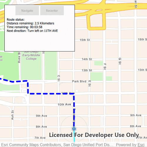
Navigation is often used by field workers while traveling between points to get live directions based on their location.
How to use the sample
Click 'Navigate' to simulate travelling and to receive directions from a preset starting point to a preset destination. Click 'Recenter' to recenter the navigation display.
How it works
- Create a
RouteTaskusing a URL to an online route service. - Generate default
RouteParametersusingRouteTask.createDefaultParameters(). - Set
returnStopsandreturnDirectionson the parameters to true. - Add
Stops to the parameters for each destination usingsetStops(stops). - Solve the route using
RouteTask.solveRoute(routeParameters)to get aRouteResult. - Create a
RouteTrackerusing the route result, and the index of the desired route to take. - Use
trackRuntimeLocation(Location)to track the location of the device and update the route tracking status. - Use the
trackingStatusResultChangedsignal to get theTrackingStatusand use it to display updated route information. Tracking status includes a variety of information on the route progress, such as the remaining distance, remaining geometry or traversed geometry (represented by aPolyline), or the remaining time, amongst others. - Use the
newVoiceGuidanceResultChangedsignal to get theVoiceGuidancewhenever new instructions are available. From the voice guidance, get thestringrepresenting the directions and use a text-to-speech engine to output the maneuver directions. - You can also query the tracking status for the current
DirectionManeuverindex, retrieve that maneuver from theRouteand get its direction text to display in the GUI. - To establish whether the destination has been reached, get the
DestinationStatusfrom the tracking status. If the destination status isEnums.DestinationStatusReached, we have arrived at the destination and can stop routing. If there are several destinations in your route, and the remaining destination count is greater than 1, switch the route tracker to the next destination.
Relevant API
- DestinationStatus
- DirectionManeuver
- Location
- Route
- RouteParameters
- RouteTask
- RouteTracker
- SimulatedLocationDataSource
- Stop
- VoiceGuidance
About the data
The route taken in this sample interacts with three locations:
- Starts at the San Diego Convention Center, site of the annual Esri User Conference
- Stops at the USS San Diego Memorial
- Ends at the Fleet Science Center, San Diego.
Tags
directions, maneuver, navigation, route, turn-by-turn, voice
Sample Code
// [WriteFile Name=NavigateRoute, Category=Routing]
// [Legal]
// Copyright 2020 Esri.
// Licensed under the Apache License, Version 2.0 (the "License");
// you may not use this file except in compliance with the License.
// You may obtain a copy of the License at
// http://www.apache.org/licenses/LICENSE-2.0
// Unless required by applicable law or agreed to in writing, software
// distributed under the License is distributed on an "AS IS" BASIS,
// WITHOUT WARRANTIES OR CONDITIONS OF ANY KIND, either express or implied.
// See the License for the specific language governing permissions and
// limitations under the License.
// [Legal]
import QtQuick
import QtQuick.Controls
import QtQuick.Layouts
import QtPositioning
import Esri.ArcGISRuntime
import Esri.samples
Rectangle {
id: rootRectangle
clip: true
width: 800
height: 600
readonly property url routeTaskUrl: "https://sampleserver6.arcgisonline.com/arcgis/rest/services/NetworkAnalysis/SanDiego/NAServer/Route"
property var m_route: null
property var m_routeResult: null
property var directionListModel: null
property string textString: ""
MapView {
id: mapView
anchors.fill: parent
Component.onCompleted: {
// Set the focus on MapView to initially enable keyboard navigation
forceActiveFocus();
}
Map {
Basemap {
initStyle: Enums.BasemapStyleArcGISNavigation
}
}
GraphicsOverlay {
id: routeOverlay
Graphic {
id: routeAheadGraphic
SimpleLineSymbol {
style: Enums.SimpleLineSymbolStyleDash
color: "blue"
width: 5
}
}
Graphic {
id: routeTraveledGraphic
SimpleLineSymbol {
style: Enums.SimpleLineSymbolStyleSolid
color: "cyan"
width: 3
}
}
Graphic {
Point {
id: conventionCenterPoint
x: -117.160386727
y: 32.706608
SpatialReference {wkid: 4326}
}
symbol: stopSymbol
}
Graphic {
Point {
id: memorialPoint
x: -117.173034
y: 32.712327
SpatialReference {wkid: 4326}
}
symbol: stopSymbol
}
Graphic {
Point {
id: aerospaceMuseumPoint
x: -117.147230
y: 32.730467
SpatialReference {wkid: 4326}
}
symbol: stopSymbol
}
}
SimpleMarkerSymbol {
id: stopSymbol
style: Enums.SimpleMarkerSymbolStyleDiamond
color: "red"
size: 20
}
Stop {
id: stop1
geometry: conventionCenterPoint
}
Stop {
id: stop2
geometry: memorialPoint
}
Stop {
id: stop3
geometry: aerospaceMuseumPoint
}
RouteTask {
id: routeTask
url: routeTaskUrl
Component.onCompleted: {
load();
}
onLoadStatusChanged: {
if (loadStatus === Enums.LoadStatusLoaded) {
createDefaultParameters();
}
}
onCreateDefaultParametersStatusChanged: {
if (createDefaultParametersStatus !== Enums.TaskStatusCompleted) {
return;
}
createDefaultParametersResult.returnStops = true;
createDefaultParametersResult.returnDirections = true;
createDefaultParametersResult.returnRoutes = true;
createDefaultParametersResult.outputSpatialReference = Factory.SpatialReference.createWgs84();
createDefaultParametersResult.setStops([stop1, stop2, stop3]);
// solve the route with these parameters
routeTask.solveRoute(createDefaultParametersResult);
}
onSolveRouteStatusChanged: {
if (solveRouteStatus === Enums.TaskStatusCompleted) {
if (solveRouteResult.routes.length > 0) {
m_routeResult = solveRouteResult;
m_route = solveRouteResult.routes[0];
mapView.setViewpointGeometryAndPadding(m_route.routeGeometry, 100);
routeAheadGraphic.geometry = m_route.routeGeometry;
navigateButton.enabled = true;
}
}
}
}
locationDisplay.onLocationChanged: {
routeTracker.trackRuntimeLocation(locationDisplay.location);
}
// enable "recenter" button
locationDisplay.onAutoPanModeChanged: {
recenterButton.enabled = locationDisplay.autoPanMode !== Enums.LocationDisplayAutoPanModeNavigation;
}
Rectangle {
id: backBox
z: 1
width: buttonRow.width * 1.5
height: 200
color: "#FBFBFB"
border.color: "black"
anchors.top: parent.top
anchors.left: parent.left
anchors.margins: 20
RowLayout {
id: buttonRow
anchors {
top: parent.top
horizontalCenter: parent.horizontalCenter
margins: 5
}
Button {
id: navigateButton
text: "Navigate"
enabled: false
onClicked: {
startNavigation();
enabled = false;
}
}
Button {
id: recenterButton
text: "Recenter"
enabled: false
onClicked: {
recenterMap();
}
}
}
Rectangle {
anchors {
top: buttonRow.bottom
left: parent.left
margins: 5
}
width: parent.width
Text {
padding: 5
width: parent.width
wrapMode: Text.Wrap
text: textString
}
}
}
SimulatedLocationDataSource {
id: simulatedLocationDataSource
}
SimulationParameters {
id: simulationParameters
velocity: 40
}
RouteTracker {
id: routeTracker
onTrackingStatusResultChanged: {
textString = "Route status: \n";
if (routeTracker.trackingStatusResult.destinationStatus === Enums.DestinationStatusApproaching || routeTracker.trackingStatusResult.destinationStatus === Enums.DestinationStatusNotReached) {
textString += "Distance remaining: " + trackingStatusResult.routeProgress.remainingDistance.displayText + " " +
trackingStatusResult.routeProgress.remainingDistance.displayTextUnits.pluralDisplayName + "\n";
const time = new Date(trackingStatusResult.routeProgress.remainingTime * 60 * 1000);
const hours = time.getUTCHours();
const minutes = time.getUTCMinutes();
const seconds = time.getSeconds();
textString += "Time remaining: " + hours.toString().padStart(2, '0') + ':' + minutes.toString().padStart(2, '0') + ':' +
seconds.toString().padStart(2, '0') + "\n";
// display next direction
if (trackingStatusResult.currentManeuverIndex + 1 < directionListModel.count) {
textString += "Next direction: " + directionListModel.get(trackingStatusResult.currentManeuverIndex + 1).directionText;
}
routeTraveledGraphic.geometry = trackingStatusResult.routeProgress.traversedGeometry;
routeAheadGraphic.geometry = trackingStatusResult.routeProgress.remainingGeometry;
} else if (routeTracker.trackingStatusResult.destinationStatus === Enums.DestinationStatusReached) {
textString += "Destination reached.\n";
// set the route geometries to reflect the completed route
routeTraveledGraphic.geometry = trackingStatusResult.routeResult.routes[0].routeGeometry;
// navigate to next stop, if available
if (trackingStatusResult.remainingDestinationCount > 1) {
switchToNextDestination();
} else {
simulatedLocationDataSource.stop();
}
}
}
// output new voice guidance
onNewVoiceGuidanceResultChanged: {
speaker.textToSpeech(newVoiceGuidanceResult.text);
}
// set a callback to indicate if the speech engine is ready to speak
speechEngineReadyCallback: function() {
return speaker.textToSpeechEngineReady();
}
}
}
NavigateRouteSpeaker {
id: speaker
}
function startNavigation() {
// get the directions for the route
directionListModel = m_route.directionManeuvers;
// set properties for route tracker
routeTracker.routeResult = m_routeResult;
routeTracker.routeIndex = 0;
// turn on mapview's navigation mode
mapView.locationDisplay.autoPanMode = Enums.LocationDisplayAutoPanModeNavigation;
// add a data source for the location display
simulatedLocationDataSource.setLocationsWithPolylineAndParameters(m_route.routeGeometry, simulationParameters);
mapView.locationDisplay.dataSource = simulatedLocationDataSource;
simulatedLocationDataSource.start();
}
function recenterMap() {
mapView.locationDisplay.autoPanMode = Enums.LocationDisplayAutoPanModeNavigation;
}
}