Display coordinate system grids including Latitude/Longitude, MGRS, UTM and USNG on a map view. Also, toggle label visibility and change the color of grid lines and grid labels.
Use case
Grids are often used on printed maps, but can also be helpful on digital maps, to identify locations on a map.
How to use the sample
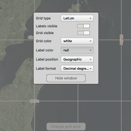
Tap on the Change Grid button in the toolbar to open a settings view. You can select type of grid from Grid Type (LatLong, MGRS, UTM and USNG) and modify its properties like label visibility, grid line color, and grid label color.
A MapView is declared with a Map that contains the imagery basemap. The MapView is initially set to use the Latitude/Longitude map grid by setting the MapView.grid property. Press the button on the bottom to display a settings window, which has several controls that modify the grid. Modifications to the grid include the grid type (MGRS, Lat/Lon, USNG, and UTM), label visibility, grid visibility, label color, grid color, label position, and label format.
How it works
- Create an instance of one of the
Gridtypes. - Grid lines and labels can be styled per grid level with
setLineSymbol(gridLevel, lineSymbol)andsetTextSymbol(gridLevel, textSymbol)methods on the grid. - The label position can be set with the
labelPositionproperty of the grid. - For the
LatitudeLongitudeGridtype, you can specify a label format ofDecimalDegreesorDegreesMinutesSeconds. - To set the grid, set
mapView.grid
Relevant API
- ArcGISGrid
- Enums.LatitudeLongitudeGridLabelFormatDecimalDegrees
- Enums.LatitudeLongitudeGridLabelFormatDegreesMinutesSeconds
- LatitudeLongitudeGrid
- MapView
- MGRSGrid
- SimpleLineSymbol
- TextSymbol
- USNGGrid
- UTMGrid
Tags
coordinates, degrees, graticule, grid, latitude, longitude, MGRS, minutes, seconds, USNG, UTM
Sample Code
// [WriteFile Name=DisplayGrid, Category=DisplayInformation]
// [Legal]
// Copyright 2016 Esri.
// Licensed under the Apache License, Version 2.0 (the "License");
// you may not use this file except in compliance with the License.
// You may obtain a copy of the License at
// http://www.apache.org/licenses/LICENSE-2.0
// Unless required by applicable law or agreed to in writing, software
// distributed under the License is distributed on an "AS IS" BASIS,
// WITHOUT WARRANTIES OR CONDITIONS OF ANY KIND, either express or implied.
// See the License for the specific language governing permissions and
// limitations under the License.
// [Legal]
import QtQuick
import QtQuick.Controls
import QtQuick.Layouts
import Esri.ArcGISRuntime
import Esri.ArcGISExtras
Rectangle {
id: rootRectangle
clip: true
width: 800
height: 600
readonly property string utmGrid: "UTM"
readonly property string usngGrid: "USNG"
readonly property string latlonGrid: "LatLon"
readonly property string mgrsGrid: "MGRS"
readonly property string dd: "Decimal degrees"
readonly property string dms: "Degrees minutes seconds"
readonly property string geographic: "Geographic"
readonly property string bottomLeft: "Bottom left"
readonly property string bottomRight: "Bottom right"
readonly property string topLeft: "Top left"
readonly property string topRight: "Top right"
readonly property string center: "Center"
readonly property string allSides: "All sides"
property string currentLabelPosition: geographic
property real centerWindowY: (rootRectangle.height / 2) - (styleWindow.height / 2)
property color currentGridColor: "red"
property color currentGridLabelColor: "black"
property string currentLabelFormat
property alias labelVisible: labelVisibleSwitch.checked
property bool gridVisible: gridVisibleSwitch.checked
MapView {
id: mapView
anchors.fill: parent
Component.onCompleted: {
// Set the focus on MapView to initially enable keyboard navigation
forceActiveFocus();
}
Map {
Basemap {
initStyle: Enums.BasemapStyleArcGISImageryStandard
}
// Set an initial viewpoint
ViewpointCenter {
targetScale: 6450785
Point {
x: -10336141.70018318
y: 5418213.05332071
spatialReference: SpatialReference { wkid: 3857 }
}
}
}
}
// change the grid color for each grid level
function changeGridColor(color) {
if (mapView.grid) {
// find the number of resolution levels in the grid
const gridLevels = mapView.grid.levelCount;
//! [DisplayGrid Set_Grid_Lines]
for (let level = 0; level < gridLevels; ++level) {
const lineSym = ArcGISRuntimeEnvironment.createObject("SimpleLineSymbol", {style: Enums.SimpleLineSymbolStyleSolid,
color: color,
width: 1 + level} );
mapView.grid.setLineSymbol(level, lineSym);
}
//! [DisplayGrid Set_Grid_Lines]
}
}
// change the grid label color for each grid level
function changeLabelColor(color) {
if (mapView.grid) {
//! [DisplayGrid Grid_Levels]
// find the number of resolution levels in the grid
const gridLevels = mapView.grid.levelCount;
//! [DisplayGrid Grid_Levels]
//! [DisplayGrid Set_Grid_Labels]
for (let level = 0; level < gridLevels; ++level) {
const textSym = ArcGISRuntimeEnvironment.createObject("TextSymbol", {
text: "text",
size: 14,
color: color,
horizontalAlignment: Enums.HorizontalAlignmentLeft,
verticalAlignment: Enums.VerticalAlignmentBottom
});
textSym.haloColor = "white";
textSym.haloWidth = 2 + level;
mapView.grid.setTextSymbol(level, textSym);
}
//! [DisplayGrid Set_Grid_Labels]
}
}
// change the grid label format
function changeLabelFormat(format) {
if (mapView.grid) {
if (mapView.grid.gridType === Enums.GridTypeLatitudeLongitudeGrid) {
if (format === dd) {
// format the labels to display in decimal degrees
mapView.grid.labelFormat = Enums.LatitudeLongitudeGridLabelFormatDecimalDegrees;
} else if (format === dms) {
//! [DisplayGrid Set_Label_Format]
// format the labels to display in degrees, minutes and seconds
mapView.grid.labelFormat = Enums.LatitudeLongitudeGridLabelFormatDegreesMinutesSeconds;
//! [DisplayGrid Set_Label_Format]
}
}
}
}
// change the grid label placement
function changeLabelPosition(position) {
if (mapView.grid) {
switch(position) {
case geographic:
//! [DisplayGrid Set_Label_Placement_Geographic]
// update the label positioning to geographic
mapView.grid.labelPosition = Enums.GridLabelPositionGeographic;
//! [DisplayGrid Set_Label_Placement_Geographic]
break;
case bottomLeft:
// update the label positioning to bottom left
mapView.grid.labelPosition = Enums.GridLabelPositionBottomLeft;
break;
case bottomRight:
// update the label positioning to bottom right
mapView.grid.labelPosition = Enums.GridLabelPositionBottomRight;
break;
case topLeft:
// update the label positioning to top left
mapView.grid.labelPosition = Enums.GridLabelPositionTopLeft;
break;
case topRight:
//! [DisplayGrid Set_Label_Placement_Top_Right]
// update the label positioning to top right
mapView.grid.labelPosition = Enums.GridLabelPositionTopRight;
//! [DisplayGrid Set_Label_Placement_Top_Right]
break;
case center:
// update the label positioning to center
mapView.grid.labelPosition = Enums.GridLabelPositionCenter;
break;
case allSides:
// update the label positioning to all sides
mapView.grid.labelPosition = Enums.GridLabelPositionAllSides;
break;
default:
mapView.grid.labelPosition = Enums.GridLabelPositionGeographic;
}
}
}
// Button to view the styling window
Rectangle {
id: styleButton
property bool pressed: false
anchors {
horizontalCenter: parent.horizontalCenter
bottom: parent.bottom
bottomMargin: 23
}
width: 150
height: 30
color: pressed ? "#959595" : "#D6D6D6"
radius: 8
border {
color: "#585858"
width: 1
}
Text {
anchors.centerIn: parent
text: "Change grid style"
font.pixelSize: 14
color: "#474747"
}
MouseArea {
anchors.fill: parent
onPressed: styleButton.pressed = true
onReleased: styleButton.pressed = false
onClicked: {
background.visible = true;
showAnimation.restart()
}
}
}
// background fade rectangle
Rectangle {
id: background
anchors.fill: parent
color: "gray"
opacity: 0.7
visible: false
border {
width: 0.5
color: "black"
}
MouseArea {
anchors.fill: parent
onClicked: mouse => mouse.accepted = true;
}
}
Rectangle {
id: styleWindow
anchors.horizontalCenter: parent.horizontalCenter
y: parent.height // initially display below the page
height: childrenRect.height
width: childrenRect.width
color: "lightgray"
radius: 4
border {
color: "black"
width: 1
}
SequentialAnimation {
id: showAnimation
NumberAnimation { target: styleWindow; property: "y"; to: centerWindowY; duration: 200 }
}
SequentialAnimation {
id: hideAnimation
NumberAnimation { target: styleWindow; property: "y"; to: rootRectangle.height; duration: 200 }
}
GridLayout {
id: grid
columns: 2
Text {
Layout.leftMargin: 10
text: "Grid type"
}
ComboBox {
id: gridTypeComboBox
property int modelWidth: 0
Layout.minimumWidth: modelWidth + leftPadding + rightPadding + (indicator ? indicator.width : 10)
Layout.rightMargin: 10
Layout.fillWidth: true
model: [latlonGrid, mgrsGrid, utmGrid, usngGrid]
onCurrentTextChanged: {
// change the grid
if (currentText === latlonGrid) {
//! [DisplayGrid Set_LatLon_Grid]
// create a grid for showing Latitude and Longitude (Meridians and Parallels)
mapView.grid = ArcGISRuntimeEnvironment.createObject("LatitudeLongitudeGrid");
//! [DisplayGrid Set_LatLon_Grid]
} else if (currentText === utmGrid) {
mapView.grid = ArcGISRuntimeEnvironment.createObject("UTMGrid");
} else if (currentText === usngGrid) {
mapView.grid = ArcGISRuntimeEnvironment.createObject("USNGGrid");
} else if (currentText === mgrsGrid) {
mapView.grid = ArcGISRuntimeEnvironment.createObject("MGRSGrid");
} else
return;
// apply any styling that has been set
changeGridColor(currentGridColor);
changeLabelColor(currentGridLabelColor);
changeLabelFormat(currentLabelFormat);
changeLabelPosition(currentLabelPosition);
mapView.grid.visible = gridVisible;
mapView.grid.labelsVisible = labelVisible;
}
Component.onCompleted : {
for (let i = 0; i < model.length; ++i) {
metricsGridTypeComboBox.text = model[i];
modelWidth = Math.max(modelWidth, metricsGridTypeComboBox.width);
}
}
TextMetrics {
id: metricsGridTypeComboBox
font: gridTypeComboBox.font
}
}
Text {
text: "Labels visible"
Layout.leftMargin: 10
enabled: gridVisibleSwitch.checked
color: enabled ? "black" : "gray"
}
Switch {
id: labelVisibleSwitch
Layout.rightMargin: 10
checked: true
enabled: gridVisibleSwitch.checked
onCheckedChanged: {
if (checked) {
mapView.grid.labelsVisible = true;
} else {
//! [DisplayGrid Label_Visible]
mapView.grid.labelsVisible = false;
//! [DisplayGrid Label_Visible]
}
}
}
Text {
Layout.leftMargin: 10
text: "Grid visible"
}
Switch {
id: gridVisibleSwitch
Layout.rightMargin: 10
checked: true
onCheckedChanged: {
if (checked) {
mapView.grid.visible = true;
} else {
//! [DisplayGrid Grid_Visible]
mapView.grid.visible = false;
//! [DisplayGrid Grid_Visible]
}
}
}
Text {
Layout.leftMargin: 10
text: "Grid color"
}
ComboBox {
id: colorCombo
property int modelWidth: 0
Layout.minimumWidth: modelWidth + leftPadding + rightPadding + (indicator ? indicator.width : 10)
Layout.rightMargin: 10
Layout.fillWidth: true
model: ["red", "white", "blue"]
onCurrentTextChanged: {
currentGridColor = currentText;
changeGridColor(currentGridColor);
}
Component.onCompleted : {
for (let i = 0; i < model.length; ++i) {
colorComboMetrics.text = model[i];
modelWidth = Math.max(modelWidth, colorComboMetrics.width);
}
}
TextMetrics {
id: colorComboMetrics
font: colorCombo.font
}
}
Text {
Layout.leftMargin: 10
text: "Label color"
}
ComboBox {
id: colorCombo2
property int modelWidth: 0
Layout.minimumWidth: modelWidth + leftPadding + rightPadding + (indicator ? indicator.width : 10)
Layout.rightMargin: 10
Layout.fillWidth: true
model: ["red", "black", "blue"]
onCurrentTextChanged: {
currentGridLabelColor = currentText;
changeLabelColor(currentGridLabelColor);
}
Component.onCompleted : {
for (let i = 0; i < model.length; ++i) {
colorCombo2Metrics.text = model[i];
modelWidth = Math.max(modelWidth, colorCombo2Metrics.width);
}
}
TextMetrics {
id: colorCombo2Metrics
font: colorCombo2.font
}
}
Text {
Layout.leftMargin: 10
text: "Label position"
color: enabled ? "black" : "gray"
}
ComboBox {
id: positionCombo
property int modelWidth: 0
Layout.minimumWidth: modelWidth + leftPadding + rightPadding + (indicator ? indicator.width : 10)
Layout.rightMargin: 10
Layout.fillWidth: true
model: [geographic, bottomLeft, bottomRight, topLeft, topRight, center, allSides]
onCurrentTextChanged: {
currentLabelPosition = currentText;
changeLabelPosition(currentLabelPosition);
}
Component.onCompleted : {
for (let i = 0; i < model.length; ++i) {
positionComboMetrics.text = model[i];
modelWidth = Math.max(modelWidth, positionComboMetrics.width);
}
}
TextMetrics {
id: positionComboMetrics
font: positionCombo.font
}
}
Text {
Layout.leftMargin: 10
text: "Label format"
enabled: mapView.grid.gridType === Enums.GridTypeLatitudeLongitudeGrid
color: enabled ? "black" : "gray"
}
ComboBox {
id: formatCombo
property int modelWidth: 0
Layout.minimumWidth: modelWidth + leftPadding + rightPadding + (indicator ? indicator.width : 10)
Layout.rightMargin: 10
Layout.fillWidth: true
model: [dd, dms]
enabled: mapView.grid.gridType === Enums.GridTypeLatitudeLongitudeGrid
onCurrentTextChanged: {
currentLabelFormat = currentText;
changeLabelFormat(currentLabelFormat);
}
Component.onCompleted : {
for (let i = 0; i < model.length; ++i) {
formatComboMetrics.text = model[i];
modelWidth = Math.max(modelWidth, formatComboMetrics.width);
}
}
TextMetrics {
id: formatComboMetrics
font: formatCombo.font
}
}
// Button to hide the styling window
Rectangle {
id: hideButton
property bool pressed: false
Layout.alignment: Qt.AlignHCenter
Layout.columnSpan: 2
Layout.bottomMargin: 5
width: 150
height: 30
color: pressed ? "#959595" : "#D6D6D6"
radius: 8
border {
color: "#585858"
width: 1
}
Text {
anchors.centerIn: parent
text: "Hide window"
font.pixelSize: 14
color: "#474747"
}
MouseArea {
anchors.fill: parent
onPressed: hideButton.pressed = true
onReleased: hideButton.pressed = false
onClicked: {
background.visible = false;
hideAnimation.restart()
}
}
}
}
}
}