Demonstrates how to animate a graphic's position and rotation and follow it using a OrbitGeoElementCameraController. Also shows how to combine a SceneView and MapView in an MVC application with property binding.
Use case
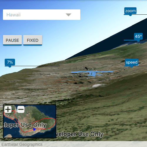
Visualize movement through a 3D landscape.
How to use the sample
Animation Controls (Top Left Corner):
- Select a mission -- selects a location with a route for the plane to fly
- Play/Pause -- toggles playing and stopping the animation
- Fixed/Follow -- toggles the camera's free cam mode and follow
- Mission progress -- shows how far along the route the plane is. Slide to change keyframe in animation
Camera Controls (Top Right Corner):
- Camare zoom -- distance between camera and plane
- Camera angle -- viewing angle between camera and plane
- Flight speed -- controls speed of animation
2D Map Controls (Bottom Left Corner):
- Plus and Minus -- controls distance of 2D view from ground level
How it works
- Create a
GraphicsOverlayand add it to theSceneView. - Create a
ModelSceneSymbolobject. - Create a
Graphicobject and set its geometry to aPoint. - Set the
ModelSceneSymbolobject to the graphic. - Add heading, pitch, and roll attributes to the graphic. Get the attributes from the graphic with
Graphic.attributes. - Create a
SimpleRendererobject and set its expression properties. - Add graphic and a renderer to the graphics overlay.
- Create an
OrbitGeoElementCameraControllerwhich is set to target the graphic. - Assign the camera controller to the
SceneView. - Update the graphic's location, heading, pitch, and roll.
Relevant API
- Camera
- GlobeCameraController
- Graphic
- GraphicsOverlay
- ModelSceneSymbol
- OrbitGeoElementCameraController
- Renderer
- Scene
- SceneProperties
- SceneView
- SurfacePlacement
Offline Data
Read more about how to set up the sample's offline data here.
| Link | Local Location |
|---|---|
| Model Marker Symbol Data | <userhome>/ArcGIS/Runtime/Data/3D/Bristol/Collada/Bristol.dae |
| GrandCanyon.csv mission data | <userhome>/ArcGIS/Runtime/Data/3D/Missions/GrandCanyon.csv |
| Hawaii.csv mission data | <userhome>/ArcGIS/Runtime/Data/3D/Missions/Hawaii.csv |
| Pyrenees.csv mission data | <userhome>/ArcGIS/Runtime/Data/3D/Missions/Pyrenees.csv |
| Snowdon.csv mission data | <userhome>/ArcGIS/Runtime/Data/3D/Missions/Snowdon.csv |
Tags
animation, camera, heading, pitch, roll, rotation, visualize
Sample Code
// [WriteFile Name=Animate3DSymbols, Category=Scenes]
// [Legal]
// Copyright 2016 Esri.
// Licensed under the Apache License, Version 2.0 (the "License");
// you may not use this file except in compliance with the License.
// You may obtain a copy of the License at
// http://www.apache.org/licenses/LICENSE-2.0
// Unless required by applicable law or agreed to in writing, software
// distributed under the License is distributed on an "AS IS" BASIS,
// WITHOUT WARRANTIES OR CONDITIONS OF ANY KIND, either express or implied.
// See the License for the specific language governing permissions and
// limitations under the License.
// [Legal]
import QtQuick
import QtQuick.Controls
import QtQuick.Layouts
import Esri.ArcGISRuntime
import Esri.ArcGISExtras
Rectangle {
id: rootRectangle
clip: true
width: 800
height: 600
readonly property url dataPath: {
Qt.platform.os === "ios" ?
System.writableLocationUrl(System.StandardPathsDocumentsLocation) + "/ArcGIS/Runtime/Data/3D" :
System.writableLocationUrl(System.StandardPathsHomeLocation) + "/ArcGIS/Runtime/Data/3D"
}
readonly property string headingAtt: "heading";
readonly property string pitchAtt: "pitch";
readonly property string rollAtt: "roll";
readonly property string attrFormat: "[%1]"
property int missionSize: currentMissionModel.count
property bool missionReady: missionSize > 0
property alias following: followButton.checked
property Graphic routeGraphic
/**
* Create SceneView that contains a Scene with the Imagery Basemap
*/
// Create a scene view
SceneView {
id: sceneView
anchors.fill: parent
Component.onCompleted: {
// Set the focus on SceneView to initially enable keyboard navigation
forceActiveFocus();
}
attributionTextVisible: (sceneView.width - mapView.width) > mapView.width // only show attribution text on the widest view
cameraController: followButton.checked && missionReady ? followController : globeController
// create a scene...scene is a default property of sceneview
// and thus will get added to the sceneview
Scene {
// add a basemap
Basemap {
initStyle: Enums.BasemapStyleArcGISImageryStandard
}
// add a surface...surface is a default property of scene
Surface {
// add an arcgis tiled elevation source...elevation source is a default property of surface
ArcGISTiledElevationSource {
url: "https://elevation3d.arcgis.com/arcgis/rest/services/WorldElevation3D/Terrain3D/ImageServer"
}
}
}
GraphicsOverlay {
id: sceneOverlay
LayerSceneProperties {
surfacePlacement: Enums.SurfacePlacementAbsolute
}
SimpleRenderer {
id: sceneRenderer
RendererSceneProperties {
id: renderProps
headingExpression: attrFormat.arg(headingAtt)
pitchExpression: attrFormat.arg(pitchAtt)
rollExpression: attrFormat.arg(rollAtt)
}
}
ModelSceneSymbol {
id: mms
url: dataPath + "/Bristol/Collada/Bristol.dae"
scale: 10.0
heading: 0.0
}
Graphic {
id: graphic3d
symbol: mms
geometry: Point {
x: 0.
y: 0.
z: 100.
spatialReference: sceneView.spatialReference
}
Component.onCompleted: {
graphic3d.attributes.insertAttribute(headingAtt, 0.);
graphic3d.attributes.insertAttribute(rollAtt, 0.);
graphic3d.attributes.insertAttribute(pitchAtt, 0.);
}
}
}
GridLayout {
anchors {
left: parent.left
right: parent.right
top: parent.top
bottom: sceneView.attributionTop
margins: 10
}
columns: 2
ComboBox {
id: missionList
property real modelWidth: 0
Layout.minimumWidth: leftPadding + rightPadding + modelWidth + (indicator ? indicator.width : 10)
enabled: !playButton.checked
model: missionsModel
textRole: "name"
// Add a background to the ComboBox
Rectangle {
anchors.fill: parent
radius: 10
// Make the rectangle visible if a dropdown indicator exists
// An indicator only exists if a theme is set
visible: parent.indicator
border.width: 1
}
onModelChanged: {
for (let i = 0; i < missionsModel.count; ++i) {
textMetrics.text = missionsModel.get(i).name;
modelWidth = Math.max(modelWidth, textMetrics.width);
}
}
onCurrentTextChanged: {
changeMission(currentText);
progressSlider.value = 0;
}
TextMetrics {
id: textMetrics
font: missionList.font
}
Component.onCompleted: missionList.currentTextChanged()
}
LabeledSlider {
id: cameraDistance
Layout.alignment: Qt.AlignRight
from: followController.minCameraDistance
to: 5000.0
value: 500.0
text: "zoom"
}
RowLayout {
Button {
id: playButton
checked: false
checkable: true
enabled: missionReady
text: checked ? "pause" : "play"
}
Button {
id: followButton
Layout.alignment: Qt.AlignRight
enabled: missionReady
text: checked? "fixed" : "follow "
checked: true
checkable: true
}
}
LabeledSlider {
id: cameraAngle
Layout.alignment: Qt.AlignRight
from: 0
to: 180.0
value: 45.0
text: "angle"
}
LabeledSlider {
id: progressSlider
from: 0
to: missionSize
enabled : missionReady
text: (value / missionSize * 100).toLocaleString(Qt.locale(), 'f', 0) + "%"
handleWidth: progressMetrics.width
TextMetrics {
id: progressMetrics
font: progressSlider.font
text: "100%"
}
}
LabeledSlider {
id: animationSpeed
Layout.alignment: Qt.AlignRight
from: 1
to: 100
value: 50
text: "speed"
}
Rectangle {
id: mapFrame
Layout.columnSpan: 2
Layout.alignment: Qt.AlignLeft | Qt.AlignBottom
Layout.minimumHeight: parent.height * 0.25
Layout.minimumWidth: parent.width * 0.3
color: "black"
clip: true
MapView {
id: mapView
objectName: "mapView"
anchors {
fill: parent
margins: 2
}
Map {
Basemap {
initStyle: Enums.BasemapStyleArcGISImageryStandard
}
}
GraphicsOverlay {
id: graphicsOverlay
Graphic {
id: graphic2d
symbol: plane2DSymbol
}
}
MouseArea {
anchors.fill: parent
onPressed: mouse => mouse.accepted = true
onWheel: wheel => wheel.accepted = true
}
}
RowLayout {
anchors {
left: parent.left
top: parent.top
}
spacing: 10
Rectangle {
Layout.margins: 5
height: width
width: childrenRect.width
clip: true
radius: 5
opacity: 0.9
Image {
source: "qrc:/Samples/Scenes/Animate3DSymbols/plus-16-f.png"
width: 24
height: width
MouseArea {
anchors.fill: parent
onClicked: zoomMapIn()
}
}
}
Rectangle {
Layout.margins: 5
height: width
width: childrenRect.width
opacity: 0.9
clip: true
radius: 5
Image {
source: "qrc:/Samples/Scenes/Animate3DSymbols/minus-16-f.png"
width: 24
height: width
MouseArea {
anchors.fill: parent
onClicked: zoomMapOut()
}
}
}
}
}
}
}
GlobeCameraController {
id: globeController
}
OrbitGeoElementCameraController {
id: followController
targetGeoElement: graphic3d
cameraDistance: cameraDistance.value
cameraPitchOffset: cameraAngle.value
}
ListModel {
id: missionsModel
ListElement{ name: "Grand Canyon"}
ListElement{ name: "Hawaii"}
ListElement{ name: "Pyrenees"}
ListElement{ name: "Snowdon"}
}
ListModel {
id: currentMissionModel
}
SimpleLineSymbol {
id: routeSymbol
style: Enums.SimpleLineSymbolStyleSolid
color: Qt.rgba(1.0, 0.0, 0.0, 1)
width: 1
antiAlias: true
}
SimpleMarkerSymbol {
id: plane2DSymbol
style: Enums.SimpleMarkerSymbolStyleTriangle
color: "blue"
size: 10
}
Timer {
id: timer
interval: 16.0 + 84 * (animationSpeed.to - animationSpeed.value) / 100.0;
running: playButton.checked;
repeat: true
onTriggered: animate();
}
FileFolder {
id: missionsFolder
path: System.resolvedPath(dataPath) + "/Missions/"
}
function changeMission(missionName) {
currentMissionModel.clear();
progressSlider.value = 0;
if (!missionsFolder.exists)
return;
const fileName = missionName.replace(/\s/g, '') + ".csv";
const fileContents = missionsFolder.readTextFile(fileName);
const lines = fileContents.split("\n");
for (let i = 0; i < lines.length; i++) {
const dataParts = lines[i].split(",");
if (dataParts.length !== 6)
continue;
currentMissionModel.append({
"lon":dataParts[0],
"lat":dataParts[1],
"elevation":dataParts[2],
"heading":dataParts[3],
"pitch":dataParts[4],
"roll":dataParts[5],
})
}
if (missionSize === 0)
return;
// create polyline builder and fill with points
// for the mission polyline
const rtBldr = ArcGISRuntimeEnvironment.createObject("PolylineBuilder", {spatialReference: Factory.SpatialReference.createWgs84()});
for (let j = 0; j < currentMissionModel.count; j++) {
const missionData = currentMissionModel.get(j);
rtBldr.addPointXY(missionData.lon, missionData.lat);
}
const firstData = currentMissionModel.get(0);
const firstPos = createPoint(firstData);
// update model graphic's attributes
graphic3d.attributes.replaceAttribute(headingAtt, firstData.heading);
graphic3d.attributes.replaceAttribute(rollAtt, firstData.roll);
graphic3d.attributes.replaceAttribute(pitchAtt, firstData.pitch);
// update model graphic's geomtry
graphic3d.geometry = firstPos;
// update the 2d graphic
graphic2d.geometry = firstPos;
plane2DSymbol.angle = firstData.heading;
if (!routeGraphic) {
// create route graphic with the route symbol
routeGraphic = ArcGISRuntimeEnvironment.createObject("Graphic");
routeGraphic.symbol = routeSymbol;
// add route graphic to the graphics overlay
graphicsOverlay.graphics.insert(0, routeGraphic);
}
// update route graphic's geomtry
routeGraphic.geometry = rtBldr.geometry;
mapView.setViewpointGeometryAndPadding(routeGraphic.geometry, 30);
}
function animate() {
if (progressSlider.value < missionSize ) {
const missionData = currentMissionModel.get(progressSlider.value);
const newPos = createPoint(missionData);
graphic3d.geometry = newPos;
graphic3d.attributes.replaceAttribute(headingAtt, missionData.heading);
graphic3d.attributes.replaceAttribute(pitchAtt, missionData.pitch);
graphic3d.attributes.replaceAttribute(rollAtt, missionData.roll);
// update the 2d graphic
graphic2d.geometry = newPos;
plane2DSymbol.angle = missionData.heading;
}
nextFrameRequested();
}
function zoomMapIn(){
mapView.setViewpointScale(mapView.mapScale / 5.0);
}
function zoomMapOut(){
mapView.setViewpointScale(mapView.mapScale * 5.0);
}
function nextFrameRequested() {
progressSlider.value = progressSlider.value + 1;
if (progressSlider.value >= missionSize)
progressSlider.value = 0;
}
function createPoint(missionData) {
return ArcGISRuntimeEnvironment.createObject(
"Point", {
x: missionData.lon,
y: missionData.lat,
z: missionData.elevation,
spatialReference: Factory.SpatialReference.createWgs84()
});
}
}