Display dimension features from a mobile map package.
Use case
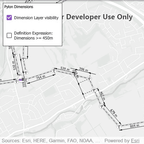
Dimensions show specific lengths or distances on a map. A dimension may indicate the length of a side of a building or land parcel, or the distance between two features, such as a fire hydrant and the corner of a building.
How to use the sample
When the sample loads, it will automatically display the map containing dimension features from the mobile map package. The name of the dimension layer containing the dimension features is displayed in the controls box. Control the visibility of the dimension layer with the "Dimension Layer visibility" check box, and apply a definition expression to show dimensions greater than or equal to 450m in length using the "Definition Expression" check box.
Note: the minimum scale range of the sample is set to 1:35000 to maintain readability of the dimension features.
How it works
- Declare a
MobileMapPackagespecifying the path to the .mmpk file. - Load the mobile map package with
mmpk.load()when theMapViewcomponent has been instantiated. - After the mmpk successfully loads, get the map from the mmpk and add it to the map view:
mapView.map = mmpk.maps[0];. - Loop through the map's layers to find the
DimensionLayerand assign the index of the dimension layer toindexOfDimensionLayer. - Set the title of the controls box using
mmpk.maps[0].operationalLayers.get(counter).name. - Control the dimension layer's visibility with
mmpk.maps[0].operationalLayers.get(indexOfDimensionLayer).visibleand set a definition expression withmmpk.maps[0].operationalLayers.get(indexOfDimensionLayer).definitionExpression.
Relevant API
- DimensionLayer
- MobileMapPackage
About the data
This sample shows a subset of the network of pylons, substations, and power lines around Edinburgh, Scotland within an Edinburgh Pylon Dimensions mobile map package. The data was digitised from satellite imagery and is intended to be used for illustrative purposes only.
Additional information
Dimension layers can be taken offline from a feature service hosted on ArcGIS Enterprise 10.9 or later, using the GeodatabaseSyncTask. Dimension layers are also supported in mobile map packages or mobile geodatabases created in ArcGIS Pro 2.9 or later.
Tags
definition expression, dimension, distance, layer, length, mmpk, mobile map package, utility
Sample Code
// [WriteFile Name=DisplayDimensions, Category=Layers]
// [Legal]
// Copyright 2021 Esri.
// Licensed under the Apache License, Version 2.0 (the "License");
// you may not use this file except in compliance with the License.
// You may obtain a copy of the License at
// http://www.apache.org/licenses/LICENSE-2.0
// Unless required by applicable law or agreed to in writing, software
// distributed under the License is distributed on an "AS IS" BASIS,
// WITHOUT WARRANTIES OR CONDITIONS OF ANY KIND, either express or implied.
// See the License for the specific language governing permissions and
// limitations under the License.
// [Legal]
import Qt.labs.platform
import QtQuick
import QtQuick.Controls
import QtQuick.Layouts
import QtQuick.Dialogs
import Esri.ArcGISRuntime
import Esri.ArcGISExtras
Rectangle {
id: rootRectangle
clip: true
width: 800
height: 600
readonly property url dataPath: {
Qt.platform.os === "ios" ?
System.writableLocationUrl(System.StandardPathsDocumentsLocation) + "/ArcGIS/Runtime/Data/mmpk/" :
System.writableLocationUrl(System.StandardPathsHomeLocation) + "/ArcGIS/Runtime/Data/mmpk/"
}
property string errorMessage: ""
property int indexOfDimensionLayer: 0
MapView {
id: mapView
anchors.fill: parent
Component.onCompleted: {
// Set and keep the focus on MapView to enable keyboard navigation
forceActiveFocus();
}
Control {
id: toggleControl
anchors {
top: mapView.top
topMargin: 10
left: mapView.left
leftMargin: 10
}
background: Rectangle {
color: "white"
border.color: "black"
}
padding: 5
contentItem: GridLayout {
columns: 1
Text {
id: toggleBoxTitle
}
CheckBox {
id: visibilityToggle
text: "Dimension Layer visibility"
checked: true
onCheckStateChanged: mmpk.maps[0].operationalLayers.get(indexOfDimensionLayer).visible = visibilityToggle.checkState;
enabled: mmpk.loadStatus === Enums.LoadStatusLoaded ? true : false
}
CheckBox {
id: definitionExpressionToggle
text: "Definition Expression: \nDimensions >= 450m"
checked: false
onCheckStateChanged: {
if (definitionExpressionToggle.checkState === Qt.Checked) {
mmpk.maps[0].operationalLayers.get(indexOfDimensionLayer).definitionExpression = "DIMLENGTH >= 450";
}
else {
mmpk.maps[0].operationalLayers.get(indexOfDimensionLayer).definitionExpression = "";
}
}
enabled: mmpk.loadStatus === Enums.LoadStatusLoaded && visibilityToggle.checked ? true : false
}
}
}
// Pop-up error message box
MessageDialog {
id: errorMessageBox
text: errorMessage
visible: errorMessage === "" ? false : true;
onAccepted: errorMessage = "";
}
}
Component.onCompleted: mmpk.load();
MobileMapPackage {
id: mmpk
path: dataPath + "Edinburgh_Pylon_Dimensions.mmpk"
onLoadStatusChanged: {
// If an error occurred during loading, pass the error onto the handleError function.
if (loadStatus === Enums.LoadStatusFailedToLoad) {
handleError(mmpk.loadError);
}
// If the mmpk has not loaded, return.
if (loadStatus !== Enums.LoadStatusLoaded) {
return;
}
// If there is more than one map, return.
if (mmpk.maps.length > 1) {
return;
}
// Set the map view's map to the first map in the mobile map package
mapView.map = mmpk.maps[0];
// Set the minimum scale as 1:35000 to prevent zooming out too far.
mapView.map.minScale = 35000;
// Loop through all layers in the mmpk and find the dimension layer.
for (let counter = 0; counter < mmpk.maps[0].operationalLayers.count; counter++) {
// Check each layer to see if it is a DimensionLayer.
if (mmpk.maps[0].operationalLayers.get(counter).layerType === Enums.LayerTypeDimensionLayer) {
// Save the index of the DimensionLayer - it is used to control layer visibility and definition expressions.
indexOfDimensionLayer = counter;
// Use the name of the DimensionLayer to define the title of the UI controls.
toggleBoxTitle.text = mmpk.maps[0].operationalLayers.get(counter).name;
// There is only one Dimension Layer, so we can break out of the loop.
break;
}
}
}
}
function handleError(error) {
if (!error.additionalMessage)
errorMessage = error.message;
else
errorMessage = error.message + "\n" + error.additionalMessage;
}
}