Display maps and use locators to enable search and routing offline using a Mobile Map Package.
Use case
Mobile map packages make it easy to transmit and store the necessary components for an offline map experience including: transportation networks (for routing/navigation), locators (address search, forward and reverse geocoding), and maps.
A field worker might download a mobile map package to support their operations while working offline.
How to use the sample
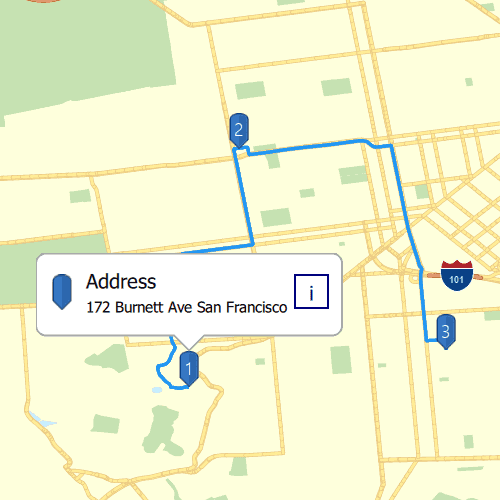
A list of maps from a mobile map package will be displayed. If the map contains transportation networks, the list item will have a navigation icon. Click on a map in the list to open it. If a locator task is available, click on the map to place a point. Click it again to reverse geocode the location's address. If transportation networks are available, click the route icon in the top right corner a route will be calculated between geocode locations.
How it works
- Create a
MobileMapPackagepassing in the path to the constructor. - Get a list model of maps inside the package using the
mapsproperty. - If the package has a locator, access it using the
LocatorTaskproperty. - To see if a map contains transportation networks, check each map's
transportationNetworksproperty.
Relevant API
- GeocodeResult
- MobileMapPackage
- ReverseGeocodeParameters
- Route
- RouteParameters
- RouteResult
- RouteTask
- TransportationNetworkDataset
Offline data
Read more about how to set up the sample's offline data here.
| Link | Local Location |
|---|---|
| Yellowstone mmpk File | <userhome>/ArcGIS/Runtime/Data/mmpk/Yellowstone.mmpk |
| SanFrancisco mmpk File | <userhome>/ArcGIS/Runtime/Data/mmpk/SanFrancisco.mmpk |
Tags
disconnected, field mobility, geocode, network, network analysis, offline, routing, search, transportation
Sample Code
// [WriteFile Name=MobileMap_SearchAndRoute, Category=Maps]
// [Legal]
// Copyright 2016 Esri.
// Licensed under the Apache License, Version 2.0 (the "License");
// you may not use this file except in compliance with the License.
// You may obtain a copy of the License at
// http://www.apache.org/licenses/LICENSE-2.0
// Unless required by applicable law or agreed to in writing, software
// distributed under the License is distributed on an "AS IS" BASIS,
// WITHOUT WARRANTIES OR CONDITIONS OF ANY KIND, either express or implied.
// See the License for the specific language governing permissions and
// limitations under the License.
// [Legal]
import QtQuick
import QtQuick.Controls
import Esri.ArcGISExtras
import Esri.ArcGISRuntime
import Esri.ArcGISRuntime.Toolkit
Rectangle {
clip: true
width: 800
height: 600
color: "#E0E0E0"
readonly property url dataPath: {
Qt.platform.os === "ios" ?
System.writableLocationUrl(System.StandardPathsDocumentsLocation) + "/ArcGIS/Runtime/Data/mmpk/" :
System.writableLocationUrl(System.StandardPathsHomeLocation) + "/ArcGIS/Runtime/Data/mmpk/"
}
property LocatorTask currentLocatorTask: null
property RouteTask currentRouteTask: null
property Point clickedPoint: null
property var currentRouteParams
property int mapPackageLoadIndex
property int selectedMmpkIndex
property int selectedMapInBundleIndex
property bool isMapOpen
property var mobileMapList: []
property var mobilePathsList: []
property var routeStops: []
// Map view UI presentation at top
MapView {
id: mapView
Component.onCompleted: {
// Set the focus on MapView to initially enable keyboard navigation
forceActiveFocus();
}
calloutData {
title : "Address";
}
// create a callout to display information
Callout {
id: callout
calloutData: parent.calloutData
screenOffsetY: -19
accessoryButtonVisible: false
leaderPosition: Callout.LeaderPosition.Automatic
}
// runs when app is geocoding
BusyIndicator {
id: busyIndicator
anchors.centerIn: parent
visible: false
}
// graphics overlay to display any routing results
GraphicsOverlay {
id: routeGraphicsOverlay
SimpleRenderer {
SimpleLineSymbol {
color: "#2196F3"
style: Enums.SimpleLineSymbolStyleSolid
width: 4
}
}
}
// graphics overlay to visually display geocoding results
GraphicsOverlay {
id: stopsGraphicsOverlay
PictureMarkerSymbol {
id: bluePinSymbol
height: 36
width: 36
url: "qrc:/Samples/Maps/MobileMap_SearchAndRoute/bluePinSymbol.png"
offsetY: height / 2
}
}
// Map controls
Column {
anchors {
top: parent.top
right: parent.right
margins: 10
}
spacing: 10
// solve route button
Rectangle {
id: routeButton
color: "#E0E0E0"
height: 50
width: height
border.color: "black"
radius: 2
opacity: 0.90
visible: false
Image {
anchors {
centerIn: parent
margins: 5
}
source: "qrc:/Samples/Maps/MobileMap_SearchAndRoute/routingSymbol.png"
height: 44
width: height
}
MouseArea {
anchors.fill: parent
onClicked: {
// only start routing if there are at least 2 stops
if (currentRouteTask.solveRouteStatus !== Enums.TaskStatusInProgress && routeStops.length >= 2) {
// clear any previous routing displays
routeGraphicsOverlay.graphics.clear();
// set stops
currentRouteParams.setStops(routeStops);
// solve route using created default parameters
currentRouteTask.solveRoute(currentRouteParams);
}
}
}
}
// clear graphics button
Rectangle {
id: clearButton
color: "#E0E0E0"
height: 50
width: height
border.color: "black"
radius: 2
opacity: 0.90
visible: false
Image {
anchors {
centerIn: parent
margins: 5
}
source: "qrc:/Samples/Maps/MobileMap_SearchAndRoute/discardSymbol.png"
height: 44
width: height
}
MouseArea {
anchors.fill: parent
onClicked: {
mapView.resetMap();
}
}
}
}
// side bar to return to map selection
Rectangle {
anchors {
left: parent.left
top: parent.top
}
opacity: 0.50
height: parent.height
width: 25
color: "#E0E0E0"
Rectangle {
anchors {
left: parent.left
top: parent.top
}
width: parent.width
height: 100
color: "#283593"
Image {
anchors.centerIn: parent
mirror: true
source: "qrc:/Samples/Maps/MobileMap_SearchAndRoute/forwardIcon.png"
height: 33
width: height
}
}
MouseArea {
anchors.fill: parent
onClicked: {
mapSelectionStack.pop();
}
}
}
onMouseClicked: mouse => {
if (currentLocatorTask !== null) {
clickedPoint = mouse.mapPoint;
identifyGraphicsOverlayWithMaxResults(stopsGraphicsOverlay, mouse.x, mouse.y, 5, false, 2);
}
}
onIdentifyGraphicsOverlayStatusChanged: {
if (identifyGraphicsOverlayStatus === Enums.TaskStatusCompleted){
// if clicked on the pin graphic, display callout.
if (identifyGraphicsOverlayResult.graphics.length > 0) {
// set callout's geoelement
mapView.calloutData.geoElement = identifyGraphicsOverlayResult.graphics[0].symbol.symbolType === Enums.SymbolTypePictureMarkerSymbol ?
identifyGraphicsOverlayResult.graphics[0] : identifyGraphicsOverlayResult.graphics[1];
mapView.calloutData.detail = mapView.calloutData.geoElement.attributes.attributeValue("AddressLabel");
callout.showCallout();
}
// otherwise, reverse geocode
else if (currentLocatorTask.geocodeStatus !== Enums.TaskStatusInProgress){
currentLocatorTask.reverseGeocodeWithParameters(clickedPoint, reverseGeocodeParams);
}
}
}
onMapChanged: {
mapView.resetMap();
// change the locatorTask
//! [MobileMap_SearchAndRoute create LocatorTask]
currentLocatorTask = mobileMapList[selectedMmpkIndex].locatorTask;
//! [MobileMap_SearchAndRoute create LocatorTask]
// determine if map supports routing
if (mobileMapList[selectedMmpkIndex].maps[selectedMapInBundleIndex].transportationNetworks.length > 0) {
currentRouteTask = ArcGISRuntimeEnvironment.createObject("RouteTask", {transportationNetworkDataset: mobileMapList[selectedMmpkIndex].maps[selectedMapInBundleIndex].transportationNetworks[0]});
currentRouteTask.load();
}
else {
currentRouteTask = null;
}
}
function resetMap() {
// reset graphic overlays
routeGraphicsOverlay.graphics.clear();
stopsGraphicsOverlay.graphics.clear();
// clear stops
routeStops = [];
// dismiss callout
callout.dismiss();
// make route controls invisible
routeButton.visible = false;
clearButton.visible = false;
}
}
// connect signals from LocatorTask
Connections {
target: currentLocatorTask
function onGeocodeStatusChanged() {
if (currentLocatorTask.geocodeStatus === Enums.TaskStatusCompleted) {
busyIndicator.visible = false;
if (currentLocatorTask.geocodeResults.length > 0) {
// create a pin graphic to display location
const pinGraphic = ArcGISRuntimeEnvironment.createObject("Graphic", {geometry: currentLocatorTask.geocodeResults[0].displayLocation, symbol: bluePinSymbol});
stopsGraphicsOverlay.graphics.append(pinGraphic);
pinGraphic.attributes.insertAttribute("AddressLabel", currentLocatorTask.geocodeResults[0].label);
if (currentLocatorTask !== null)
clearButton.visible = true;
// add geocoded point as a stop if routing is available for current map
if (currentRouteTask !== null) {
const stop = ArcGISRuntimeEnvironment.createObject("Stop", {name: "stop", geometry: pinGraphic.geometry});
routeStops.push(stop);
if (routeStops.length > 1)
routeButton.visible = true;
// create a Text symbol to display stop number
const textSymbol = ArcGISRuntimeEnvironment.createObject("TextSymbol", {
color: "white",
text: routeStops.length,
size: 18,
offsetY: 19
});
// create graphic using the text symbol
const labelGraphic = ArcGISRuntimeEnvironment.createObject("Graphic", {geometry: pinGraphic.geometry, symbol: textSymbol});
labelGraphic.zIndex = pinGraphic.zIndex + 1;
stopsGraphicsOverlay.graphics.append(labelGraphic);
}
}
}
else
busyIndicator.visible = true;
}
}
// connect signals from RouteTask
Connections {
target: currentRouteTask
// if RouteTask loads properly, create the default parameters
function onLoadStatusChanged() {
if (currentRouteTask.loadStatus === Enums.LoadStatusLoaded) {
currentRouteTask.createDefaultParameters();
}
}
// obtain default parameters
function onCreateDefaultParametersStatusChanged() {
if (currentRouteTask.createDefaultParametersStatus === Enums.TaskStatusCompleted)
currentRouteParams = currentRouteTask.createDefaultParametersResult;
}
function onSolveRouteStatusChanged() {
// if route solve is successful, add a route graphic
if(currentRouteTask.solveRouteStatus === Enums.TaskStatusCompleted) {
const routeTaskResult = currentRouteTask.solveRouteResult;
if (routeTaskResult !== null && routeTaskResult.routes.length > 0) {
const routeGraphic = ArcGISRuntimeEnvironment.createObject("Graphic", {geometry: routeTaskResult.routes[0].routeGeometry});
routeGraphicsOverlay.graphics.append(routeGraphic);
}
else {
console.log("Route could not be solved");
}
}
// otherwise, console error message
else if (currentRouteTask.solveRouteStatus === Enums.TaskStatusErrored)
console.log(currentRouteTask.error.message);
}
}
// create reverse geocoding parameters
ReverseGeocodeParameters {
id: reverseGeocodeParams
maxResults: 1
resultAttributeNames: ["Address", "Neighborhood", "City", "Region", "Street"]
}
StackView {
id: mapSelectionStack
anchors.fill: parent
initialItem: Item {
Column {
anchors {
top: parent.top
left: parent.left
}
width: parent.width
spacing: 20
// UI navigation bar
Rectangle {
width: parent.width
height: 100
color: "#283593"
// forward navigation button. Visible after first map is selected
Image {
anchors {
verticalCenter: parent.verticalCenter
right: parent.right
margins: 10
}
source: "qrc:/Samples/Maps/MobileMap_SearchAndRoute/forwardIcon.png"
height: 44
width: height
visible: isMapOpen
MouseArea {
anchors.fill: parent
onClicked: {
mapSelectionStack.push(mapSelectView);
}
}
}
Text {
anchors.centerIn: parent
color: "white"
height: 40
font.pixelSize: 25
text: "Choose a Mobile Map Package"
}
}
// ListModel to store names of Mobile Map Packages in data folder
ListModel {
id: mobileMapPackages
}
// mobile map package ListView
ListView {
anchors.horizontalCenter: parent.horizontalCenter
height: 400
width: 200
spacing: 10
model: mobileMapPackages
delegate: Component {
Rectangle {
width: 200
height: 50
color: "#283593"
radius: 2
border.color: "darkgray"
Text {
anchors.centerIn: parent
horizontalAlignment: Text.AlignHCenter
color: "white"
width: 150
text: modelData
elide: Text.ElideMiddle
}
MouseArea {
anchors.fill: parent
propagateComposedEvents: false
onClicked: {
isMapOpen = false;
// reset map list
mapsInBundle.clear();
// create the list of maps within a package
for (let i = 0; i < mobileMapList[index].maps.length; i++) {
let mapTitle = mobileMapList[index].maps[i].item.title;
mapTitle += " " + (i + 1);
// add to ListModel
mapsInBundle.append({"name": mapTitle, "routing": mobileMapList[index].maps[i].transportationNetworks.length > 0, "geocoding": mobileMapList[index].locatorTask !== null});
}
selectedMmpkIndex = index;
mapSelectionStack.push(mapSelectView);
}
}
}
}
}
}
}
Item {
id: mapSelectView
Column {
anchors {
top: parent.top
left: parent.left
}
width: parent.width
spacing: 20
// UI navigation bar
Rectangle {
width: parent.width
height: 100
color: "#283593"
// back button
Image {
anchors {
verticalCenter: parent.verticalCenter
left: parent.left
margins: 10
}
mirror: true
source: "qrc:/Samples/Maps/MobileMap_SearchAndRoute/forwardIcon.png"
height: 44
width: height
MouseArea {
anchors.fill: parent
onClicked: {
mapSelectionStack.pop();
}
}
}
// forward button. Only visible after first map has been selected
Image {
anchors {
verticalCenter: parent.verticalCenter
right: parent.right
margins: 10
}
source: "qrc:/Samples/Maps/MobileMap_SearchAndRoute/forwardIcon.png"
height: 44
width: height
visible: isMapOpen
MouseArea {
anchors.fill: parent
onClicked: {
mapSelectionStack.push(mapView);
}
}
}
Text {
anchors.centerIn: parent
color: "white"
height: 40
font.pixelSize: 25
text: "Choose a Map"
}
}
// maps contained in a MobileMapPackage
ListModel {
id: mapsInBundle
}
// list of maps
ListView {
anchors.horizontalCenter: parent.horizontalCenter
height: 400
width: 200
spacing: 10
model: mapsInBundle
delegate: Component {
Rectangle {
width: 200
height: 50
color: "#283593"
radius: 2
border.color: "darkgray"
Text {
anchors.centerIn: parent
horizontalAlignment: Text.AlignHCenter
color: "white"
width: 150
text: name
elide: Text.ElideMiddle
}
// geocoding available icon
Image {
anchors {
left: parent.left
top: parent.top
margins: 5
}
source: "qrc:/Samples/Maps/MobileMap_SearchAndRoute/pinOutlineSymbol.png"
height: 20
width: height
visible: geocoding
}
// routing available icon
Image {
anchors {
right: parent.right
top: parent.top
margins: 5
}
source: "qrc:/Samples/Maps/MobileMap_SearchAndRoute/routingSymbol.png"
height: 20
width: height
visible: routing
}
MouseArea {
anchors.fill: parent
propagateComposedEvents: false
onClicked: {
isMapOpen = true;
// set map and display mapView
selectedMapInBundleIndex = index;
// set map
mapView.map = mobileMapList[selectedMmpkIndex].maps[index];
mapSelectionStack.push(mapView);
}
}
}
}
}
}
}
}
FileFolder {
id: mmpkFolder
url: dataPath
// recursively create and load MobileMapPackages
function loadMmpks() {
if (mapPackageLoadIndex < mobilePathsList.length) {
const index = mapPackageLoadIndex;
const mobileMap = ArcGISRuntimeEnvironment.createObject("MobileMapPackage", { path: mobilePathsList[index] });
mobileMap.load();
mobileMap.loadStatusChanged.connect(()=> {
// after mmpk is loaded, add it to the list of mobile map packages
if (mobileMap.loadStatus === Enums.LoadStatusLoaded) {
const title = mobileMap.item.title;
mobileMapList.push(mobileMap);
mobileMapPackages.append({"name": title});
}
});
mapPackageLoadIndex++;
loadMmpks();
}
}
Component.onCompleted: {
// search through every file in the folder
for (let i = 0; i < mmpkFolder.fileNames().length; i++) {
// if it is an mmpk file, store its path
if (mmpkFolder.fileInfo(mmpkFolder.fileNames()[i]).suffix === "mmpk") {
mobilePathsList.push(mmpkFolder.url + "/" + mmpkFolder.fileInfo(mmpkFolder.fileNames()[i]).fileName);
}
}
// then create a MobileMapPackage with the stored paths
loadMmpks();
}
}
}