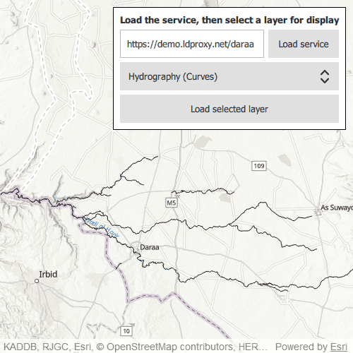
Browse an OGC API feature service for layers and add them to the map.
Use case
OGC API standards are used for sharing geospatial data on the web. As an open standard, the OGC API aims to improve access to geospatial or location information and could be a good choice for sharing data internationally or between organizations. That data could be of any type, including, for example, transportation layers shared between government organizations and private businesses.
How to use the sample
Select a layer to display from the drop-down list of layers available from the OGC API service. The Daraa data is used as the default feature service, however, alternative feature services can be used.
How it works
- Create an
OgcFeatureServiceobject with a URL to an OGC API feature service. - Create a list of feature collections from the
OgcFeatureService.OgcFeatureServiceInfo.FeatureCollectionInfos. - When a feature collection is selected, create an
OgcFeatureCollectionTablefrom the list of feature collections. - Populate the
OgcFeatureCollectionTableusingPopulateFromServicewithQueryParametersthat contain aMaxFeaturesproperty. - Create a feature layer from the feature table.
- Add the feature layer to the map.
Relevant API
- OgcFeatureCollectionInfo
- OgcFeatureCollectionTable
- OgcFeatureService
- OgcFeatureServiceInfo
About the data
The Daraa, Syria test data is OpenStreetMap data converted to the Topographic Data Store schema of NGA.
Additional information
See the OGC API website for more information on the OGC API family of standards.
Tags
browse, catalog, feature, layers, OGC, OGC API, service, web
Sample Code
// [WriteFile Name=BrowseOGCAPIFeatureService, Category=Layers]
// [Legal]
// Copyright 2021 Esri.
// Licensed under the Apache License, Version 2.0 (the "License");
// you may not use this file except in compliance with the License.
// You may obtain a copy of the License at
// http://www.apache.org/licenses/LICENSE-2.0
// Unless required by applicable law or agreed to in writing, software
// distributed under the License is distributed on an "AS IS" BASIS,
// WITHOUT WARRANTIES OR CONDITIONS OF ANY KIND, either express or implied.
// See the License for the specific language governing permissions and
// limitations under the License.
// [Legal]
import QtQuick
import QtQuick.Controls
import QtQuick.Layouts
import Esri.ArcGISRuntime
Rectangle {
id: root
clip: true
width: 800
height: 600
property url serviceURL: "https://demo.ldproxy.net/daraa"
property OgcFeatureService featureService: null
property FeatureLayer featureLayer : null
property string errorMessage: ""
MapView {
id: mapView
anchors.fill: parent
Component.onCompleted: {
// Set the focus on MapView to initially enable keyboard navigation
forceActiveFocus();
}
Map {
id: map
Basemap {
initStyle: Enums.BasemapStyleArcGISTopographic
// When the map has loaded, connect to the OGC Feature Service
onComponentCompleted: loadFeatureService(serviceURL);
}
}
// Add the OGC feature service UI element
Control {
id: uiControl
anchors {
right: parent.right
top: parent.top
margins: 10
}
padding: 10
background: Rectangle {
color: "white"
border.color: "black"
}
contentItem: GridLayout {
columns: 2
Label {
id: instructionLabel
text: "Load the service, then select a layer for display"
font.bold: true
verticalAlignment: "AlignVCenter"
horizontalAlignment: "AlignHCenter"
Layout.columnSpan: 2
Layout.fillWidth: true
}
TextField {
id: serviceURLBox
text: serviceURL
Layout.fillWidth: true
selectByMouse: true
}
Button {
id: connectButton
text: "Load service"
enabled: featureService.loadStatus !== Enums.LoadStatusLoading
onClicked: {
serviceURL = serviceURLBox.text;
loadFeatureService(serviceURL);
}
}
ComboBox {
id: featureCollectionListComboBox
Layout.columnSpan: 2
Layout.fillWidth: true
Layout.fillHeight: true
textRole: "title"
model: featureService.loadStatus === Enums.LoadStatusLoaded ? root.featureService.serviceInfo.featureCollectionInfos : [];
}
Button {
id: loadLayerButton
text: "Load selected layer"
enabled: featureCollectionListComboBox.model.length > 0
onClicked: loadFeatureCollection(featureCollectionListComboBox.currentIndex);
Layout.columnSpan: 2
Layout.fillWidth: true
}
}
}
// Pop-up error message box
Dialog {
id: errorMessageBox
visible: errorMessage === ""? false : true
title: errorMessage
standardButtons: Dialog.Ok
x: (parent.width - width) / 2
y: (parent.height - height) / 2
}
QueryParameters {
id: queryParameters
maxFeatures: 1000
}
}
function loadFeatureService(currentUrl) {
// Create feature service object and assign to featureService property
root.featureService = ArcGISRuntimeEnvironment.createObject("OgcFeatureService", {url: currentUrl}, map);
// Connect loaded signal to checkForLoadingErrors() function
root.featureService.loadStatusChanged.connect(checkForLoadingErrors);
featureService.load();
}
function handleError(error) {
if (!error.additionalMessage)
errorMessage = error.message;
else
errorMessage = error.message + "\n" + error.additionalMessage;
}
function checkForLoadingErrors() {
if (root.featureService.loadStatus === Enums.LoadStatusFailedToLoad) {
handleError(root.featureService.loadError);
}
}
function loadFeatureCollection(selectedFeature) {
// Create featureCollectionTable object
let featureCollectionTable = ArcGISRuntimeEnvironment.createObject("OgcFeatureCollectionTable");
// Set request mode to manual cache
featureCollectionTable.featureRequestMode = Enums.FeatureRequestModeManualCache;
// Copy info for selected feature collection into featureCollectionTable
featureCollectionTable.featureCollectionInfo = featureService.serviceInfo.featureCollectionInfos[selectedFeature];
// Populate featureCollectionTable
featureCollectionTable.populateFromService(queryParameters, true, []);
// Create feature layer object and assign to featureLayer property
root.featureLayer = ArcGISRuntimeEnvironment.createObject("FeatureLayer", { featureTable: featureCollectionTable } );
// Connect loadStatusChanged to checkIfLayerLoaded function
root.featureLayer.loadStatusChanged.connect(checkIfLayerLoaded);
root.featureLayer.load();
}
function checkIfLayerLoaded() {
if (root.featureLayer.loadStatus === Enums.LoadStatusFailedToLoad) {
handleError(root.featureLayer.loadError);
return;
}
else if (root.featureLayer.loadStatus !== Enums.LoadStatusLoaded) {
return;
}
addFeatureLayerToMap();
}
function addFeatureLayerToMap() {
map.operationalLayers.clear();
// Add selected feature layer to the map
map.operationalLayers.append(root.featureLayer);
// Set the viewpoint of the map
mapView.setViewpointGeometry(root.featureLayer.fullExtent);
}
}